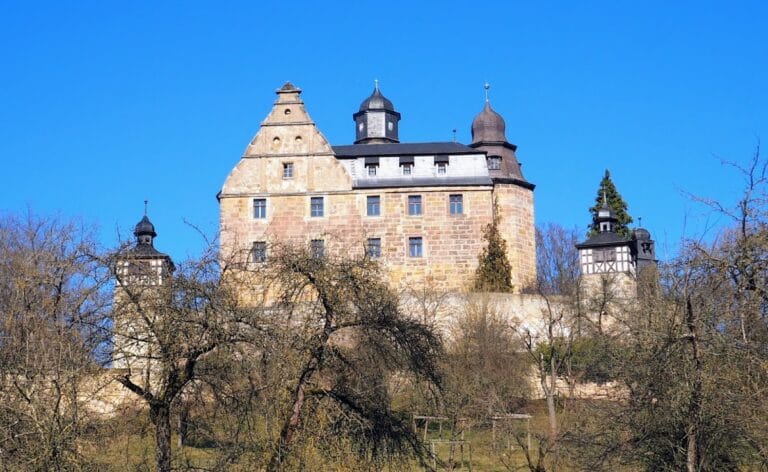
Rosenberg Fortress: A Bamberg Stronghold Above Kronach, Germany


Site at a Glance
- Rating
- 4.7
- Popularity
- Medium
- Country
- Germany
- Primary era
- Early Modern
- External website
- Open
- Eras represented
- Medieval, Early Modern, Modern
- Civilizations
- German, Holy Roman Empire
- Site type
- Military
- Remains
- Castle
On this page24 sections
History
Rosenberg Fortress is a medieval castle and later fortress above Kronach in Germany, built and expanded under the Prince-Bishopric of Bamberg from the thirteenth century onward. Rising on Rosenberg above the meeting area of the Kronach, Haßlach, and Rodach valleys, it developed through medieval, Renaissance, and Baroque phases into one of Bavaria’s largest and best-preserved fortresses. Its position controlled routes toward Thuringia and the Franconian Forest and made it both a defensive stronghold and a protected residence for Bamberg’s prince-bishops.
Origins and the Medieval Castle
Rosenberg probably originated in the period of Otto I of Bamberg, who received Kronach and the surrounding Praedium Crana from Emperor Henry V in 1122. Records of Michaelsberg Abbey state that Otto had a stone house and tower built near Kronach around 1130. Archaeology has not established that these buildings stood on Rosenberg. A twelfth-century tower-house foundation found in 1989 lies at a settlement about 3 kilometres north of the present town centre, and may relate to this earlier activity.
The name Rosenberg appears for the first time as “Rosenberc” in a letter written by Pope Innocent IV on 12 June 1249. The Treaty of Langenstadt, concluded in 1260, referred to the castrum in Ronssenberg, showing that a castle stood on the hill by the middle of the thirteenth century. The surviving square keep, or Bergfried, probably dates from the second half of that century and is the oldest building still standing within the fortress.
Kronach and its surrounding territory remained part of the Prince-Bishopric of Bamberg from 1122 until the principality was secularized at the beginning of the nineteenth century. A prince-bishop combined religious authority with territorial and governmental power. The Bamberg rulers strengthened Rosenberg during the fourteenth and fifteenth centuries, gradually transforming the medieval defensive castle into a more extensive fortified residence. By the late fifteenth century, a second ring of fortifications had been built, mainly under Prince-Bishop Philipp von Henneberg.
Renaissance Expansion and Sixteenth-Century Conflicts
Under Prince-Bishop Veit II von Würtzburg, Renaissance construction sought to establish Rosenberg as a third Bamberg residence after Bamberg and Forchheim. The fortress was also one of the two territorial fortresses of the prince-bishopric, together with Forchheim Fortress. These changes combined residential and representational functions with increasingly powerful defenses.
Rosenberg and Kronach were drawn into the German Peasants’ War in 1525, a widespread uprising against social, economic, and political conditions in the German lands. The town council and citizens, led by the episcopal steward Kunz Dietmann, surrendered the town and fortress to the rebels without a fight. After the uprising was suppressed, Prince-Bishop Weigand von Redwitz executed four rebel leaders. Dietmann was spared after paying 800 gulden, while Kronach was fined 2,000 gulden.
During the Second Margrave War, Albrecht II Alcibiades, Margrave of Brandenburg-Kulmbach, approached Kronach on 10 October 1553 and demanded its surrender. He withdrew because his force was too small to besiege the fortified town and castle. The episode demonstrated the defensive value of the combined urban and hilltop stronghold.
Seventeenth-Century Siege Warfare
Swedish and allied forces attacked and besieged Kronach and Rosenberg repeatedly between 1632 and 1634 during the Thirty Years’ War, the major European conflict of 1618 to 1648 that combined religious, dynastic, and territorial struggles. The town and fortress were successfully defended and were never taken by force. Kronach’s women participated in the defense alongside the other defenders.
In recognition of the successful resistance, Prince-Bishop Melchior Otto Voit von Salzburg granted Kronach a new coat of arms and civic privileges in 1651. The citizens erected an honor column for him in 1654. An annual Sweden procession commemorating the defense has passed through the old town and fortress since 1633.
The war also showed that the earlier forward defenses could not withstand contemporary artillery effectively. Afterward, four earlier bastions were replaced by five stone Baroque bastions. Four northern outworks, additional earthworks, and underground mining galleries were added to strengthen the principal approach, especially on the more accessible northern side of Rosenberg.
Eighteenth-Century Fortifications and the End of Military Rule
Rosenberg was tested during the Seven Years’ War, the conflict from 1756 to 1763 that pitted major European powers against one another. On 10 May 1759, Prussian troops under Major General Karl Gottfried von Knobloch shelled Kronach from the Kreuzberg east of the town. Their field artillery could not reach the fortress effectively, while Rosenberg’s guns reached the Prussian positions and forced the bombardment to end.
After the secularization of the Prince-Bishopric of Bamberg, Kronach and Rosenberg passed to Bavaria in 1803, de facto in 1802. The fortress initially remained a garrison because of its strategic position, but its military importance declined as warfare shifted from siege operations toward maneuver warfare and artillery ranges increased. Most of its equipment was transferred to Würzburg or sold in 1805.
Napoleon Bonaparte’s army used Rosenberg as a camp in October 1806 before its campaign against Prussia. Napoleon ordered the destruction of the fourteen bartizans, or corner watchhouses, on the bastions and the watchhouse on Contregarde Carl because they could provide aiming points for enemy artillery. Some of these structures were reconstructed during the twentieth century.
In 1812, while preparations were under way for Napoleon’s invasion of Russia, Kronach became a staging point for French, Italian, and Bavarian troops. Rosenberg was placed on a war footing, its garrison was increased, and new guns were installed. The fortress was prepared for defense again in 1813, although no fighting took place in the Kronach area. It was armed several more times, most recently during the Austro-Prussian War in 1866, without becoming the scene of major combat.
Prison, Ownership, and Twentieth-Century Uses
After its formal military status was abolished on 10 May 1867, Rosenberg functioned as a military prison. In 1869 it became a civil prison for about 100 people while remaining under military administration. Among the prisoners were political Catholics who opposed closer Bavarian alignment with Prussia, including the journalist Johann Baptist Sigl. After the outbreak of the Franco-Prussian War, King Ludwig II pardoned these prisoners so that French prisoners of war could be held there. The prison closed in 1875.
Kronach purchased the 23.6-hectare fortified property on 14 May 1888 for 32,000 marks, preventing its demolition. The fortress remains the city’s sole property. During the First World War, the Bavarian Army operated an officers’ prisoner-of-war camp there. Over four years it held 98 French officers and 24 French soldiers, 206 Russian officers and 64 Russian soldiers, 29 English officers, and one Belgian officer with eight soldiers. The prisoners were allowed to take walks outside the fortress on their word of honor.
French captain Charles de Gaulle was interned at Rosenberg from 20 July to 21 November 1917. Following two escape attempts, he was transferred to Ingolstadt Fortress and later to Wülzburg. After the camp closed in November 1918, parts of the fortress were used for civilian housing, including accommodation for the mayor and senior officials. During the Second World War, Polish and Soviet forced laborers assigned to the Rosenthal porcelain factory in Kronach lived there from 1942 to 1944.
Toward the end of the Second World War, the fortress was adapted under the code name “GeKro” for planned production of components for the Messerschmitt Me 163, a German rocket-powered fighter aircraft. Organisation Todt altered several casemates and began concrete works, but the production halls were never completed or operated. After 1945, Rosenberg temporarily served as a refugee camp, and some permanent apartments remained in use into the 1980s.
Modern Conservation and Public Uses
Rosenberg is protected as a listed monument and remains owned solely by Kronach. Restoration and accessibility work continued under a fortress-use plan adopted in 2008 in cooperation with the Bavarian State Office for Monument Protection. The Franconian Gallery, a branch museum of the Bavarian National Museum, has occupied the south wing since July 1983. The east wing has hosted temporary exhibitions since 1994, while other parts of the fortress contain a hostel, hotel facilities, event spaces, and related public uses.
The north and west wings were restored and expanded for hotel use by 2019, and the New Arsenal received an event hall for about 200 people. The fortress also hosts the Rosenberg Festival on an open-air stage at St. Heinrich Bastion and the rock festival Die Festung rockt in the outer moat. The Rosenberg Festival began in 1995 as the Faust Festival and continued under its present name and revised concept from 2016.
Remains
Setting and Overall Layout
Rosenberg Fortress stands about 378 metres above sea level on a north-south ridge of Upper Buntsandstein above Kronach. The southern and eastern slopes are steep, while the northern ridge is comparatively level. This northern side formed the principal approach and attack direction. The fortress overlooks the confluence area of the Kronach, Haßlach, and Rodach valleys, and its position explains the concentration of defensive works toward the north.
The complex consists of three concentric rings. The built-over area, including three moats and outer works, covers about 8.5 hectares. With the former earthworks in the northern forefield, the fortified terrain once extended across about 23.6 hectares. Rubble stone, rusticated ashlar, and ashlar masonry form the principal construction materials.
Core Castle
Residential and Service Wings
The innermost ring is the core castle, formed by four approximately rectangular wings and two northern corner towers, the Schmiedsturm and Nordostturm. Much of its present appearance dates from the late sixteenth century, although sections of the foundations belong to the fourteenth century. The east wing, known as the Fürstenbau, contained the prince-bishop’s residential and representational rooms, including the Fürstensaal and Fürstenküche.
The basement of the east wing contains the Spitaltor, the oldest surviving entrance and formerly the only entry to the core castle. It originally had a drawbridge, a heavy oak door, and a wolf pit, a defensive pit below or near a gate. The original wooden gate leaf survives. The wolf pit was removed, and the drawbridge was replaced by a stone bridge in the eighteenth century.
North, West, and South Wings
The north and west wings contained servants’ and guests’ quarters, stables, storage rooms, and workshops. The west wing is known as the Gesindebau. The south wing formerly included the castle chapel and was largely demolished and rebuilt as the Baroque New Barracks between 1730 and 1733. Now called the Kommandantenbau, it has the fortress’s only plastered facade and houses the Franconian Gallery. Its interior was extensively rebuilt on the original plan in the early 1980s.
Bergfried and Wells
The courtyard contains the approximately 38-metre-high Bergfried, a square keep probably built in the second half of the thirteenth century. Its entrance is about 12 metres above ground level. Before a narrow stair tower was added in the sixteenth century, the entrance could be reached only by ladder. A Welsch hood and the adjoining watchroom were removed in the nineteenth century, after which the present roof was installed.
A well about 45 metres deep lies on the south side of the core-castle courtyard and is fed by several springs. An additional well in an extension of the Nordostturm supplied the adjacent Fürstenküche. A separate draw well about 30 metres deep stands in the Zeughaushof. It served as a horse trough and supplied a washhouse that has since been demolished.
Middle Ring and Military Buildings
Walls and Towers
The irregular middle ring surrounds the core castle. Built mainly during the late Gothic period at the end of the fifteenth century, it contains the Zeughaustorbau, the Old and New Arsenals, the Provianthaus, a war-powder magazine, and a defensive wall with seven towers. The ring was repeatedly altered and extended. Its northern defensive wall, called the Henneberg retaining wall, is up to 14 metres thick and consists internally mainly of earth and rubble rather than solid masonry.
The upper level of the Henneberg retaining wall contained the fortress commander’s garden. The top floor of the powder tower attached to its outer side served as a garden house. On the eastern side, the Salzturm began as a shell tower open toward the interior. It was closed and raised by one story in the sixteenth century for the dry storage of salt and gunpowder.
Stores, Arsenals, and the Geschützhof
The Provianthaus contains seven basement rooms with barrel-vaulted ceilings and was later enlarged for use as a war-powder magazine. The small area between the Salzturm, Provianthaus, and east wing is called the Geschützhof, or Reitschule. During wartime, horses were exercised there when leaving the fortress was unsafe.
The Artillery Barracks, a long building added outside the ring in 1701, partly conceals firing loopholes in the wall behind it. Its former timber-framed upper story was replaced by ashlar masonry in 1848. West of the Provianthaus and Artillery Barracks stands the Schieferturm. A round tower south of the Kommandantenbau was converted into a stairway in the eighteenth century.
The Kapitänsturm and Dicke Turm flank the Zeughaustorbau. The Dicke Turm was converted into an artillery tower in the sixteenth century. It has five stories and walls up to 4 metres thick. The Zeughaustorbau contains a gate installed in the fifteenth century and was later enlarged into a residential wing.
Arsenals and Gate Structures
The Old and New Arsenals meet at a slight angle and were mainly used to store weapons and military equipment. The Old Arsenal also contained stables, administrative rooms for the Kronach captaincy, and a granary for tithe grain. The Luntenturm at the angle stored tow and slow matches used with firearms. The Great Wall Bridge, about 12 metres high and 17 metres long, crosses the northeastern middle moat between the Pulverturm and Salzturm. The smaller Wall Bridge is attached to the Old Arsenal. Both are wooden bridges on stone piers and could be filled with combustible material and burned during an assault.
Baroque Bastions and Principal Gate
Five Bastions
The outer ring consists of five Baroque bastions, projecting fortifications designed to provide flanking fire along adjoining walls, and the curtain walls between them. Together they form a regular pentagon externally while following the irregular curve of the middle ring internally. Numbered clockwise from the southern entrance, the bastions are St. Kunigunde, St. Valentin, St. Lothar, St. Philipp, and St. Heinrich.
Each bastion has a large sculptural coat-of-arms stone. Their flanks, casemates, or vaulted protected chambers, and observation arrangements were designed to remove areas that could not be reached by defensive fire and to allow guns to sweep the ground before the curtain walls. Recessed gun casemates, partly lowered flanks, and projecting corner watchhouses survive within the bastion system. The watchhouses are twentieth-century reconstructions because the originals were destroyed in 1806.
Principal Gate
The principal gate stands between the two southern bastions. Built in 1662 under Prince-Bishop Philipp Valentin Voit von Rieneck, it was placed in front of an existing curtain wall. Johann Christein carried out the construction, while the design is probably attributable to Antonio Petrini. Three parallel tunnels pass through the gate, following deliberately angled courses that prevented direct sight and fire toward the core castle.
The central tunnel carried vehicles, the smaller left-hand tunnel served pedestrians, and the right-hand tunnel could be reached only from inside and ended externally in an “ox-eye” opening. The gate originally had a forward moat, drawbridge, and portcullis, a vertically dropping gate. These were removed after the fortress lost its military status in 1867. Openings for pouring pitch or boiling water remain at both ends of the vehicle and pedestrian tunnels, together with loopholes for firing at attackers in the gate hall.
Northern Outworks and Siege Defenses
Contregarde Carl and Ravelin Anton
Four northern outworks were built in the eighteenth century to obstruct approaches and protect the two northern bastions from direct fire. Contregarde Carl, also called Work VI, lies opposite St. Lothar. A contregarde is an outwork positioned to shield a bastion. Its inward-facing curve is casemated and contains six low-level cannon loopholes covering the outer moat. Its northern point formerly carried a watchtower.
Ravelin Anton, or Work VII, lies west of Contregarde Carl and protects the curtain between St. Lothar and St. Valentin. A ravelin is an outwork placed before a curtain wall to obstruct attackers and protect the wall. Ravelin Anton has an arrowhead-like plan rather than the more usual triangular form.
Waffenplätze and Glacis
Work VIII, the unnamed Waffenplatz, lies before St. Valentin. Waffenplatz Philipp, or Work IX, lies southeast of Contregarde Carl. Both are sandstone-built works at the same level as the other outworks. Their plans are irregular, and they do not make direct contact with the glacis, the deliberately cleared sloping ground outside a fortress that exposes approaching troops.
The northern glacis formed part of the defensive system and was kept free of high vegetation. Several earthworks and underground galleries were built there for mine warfare. During a siege, the galleries could have been extended beneath enemy lines to place explosives. A wartime passage cut into the northern wall of Bastion St. Philipp and later sealed was reopened as a barrier-free entrance from the parking area by the end of 2020.
Inscriptions and Later Alterations
Numerous building inscriptions and heraldic panels associated with Bamberg’s prince-bishops survive throughout the fortifications. Some panels were probably reused from demolished buildings during later construction, which makes individual attributions of building phases uncertain.
Later military changes remain visible in several parts of the complex. A shell-proof vault built over the courtyard well in 1813 was demolished in 1919. During the Second World War, the St. Philipp casemate received a concrete intermediate floor and a supply opening that was later sealed. In the St. Lothar casemate, two cannon loopholes were closed and a third was converted into an entrance. Concrete foundations were also installed between Contregarde Carl and Waffenplatz Philipp for a roof structure that was never realized.