Nero’s Aqueduct (Resti dell’Acquedotto Neroniano): Roman Waterway in Rome

Site at a Glance
- Rating
- 4.4
- Popularity
- Very Low
- Country
- Italy
- Primary era
- Classical
- Eras represented
- Classical
- Civilizations
- Roman
- Site type
- Infrastructure
- Remains
- Aqueduct
On this page10 sections
History
Nero’s Aqueduct, known in Italian as Resti dell’Acquedotto Neroniano, is the ruined remains of a Roman waterway in Rome, Italy, built under the emperor Nero between AD 54 and 68. It was constructed as a branch of the Aqua Claudia, a major Roman aqueduct completed in AD 52, rather than as an independent water system. The new line supplied Nero’s Domus Aurea, or Golden House, and its adjoining artificial lake, while also serving the Temple of the Divine Claudius and its associated nymphaeum, a monumental structure connected with a spring or water display, on the Caelian Hill.
Construction under Nero
The aqueduct began at Spes Vetus, near Porta Maggiore. Its first section followed the underground course of the Aqua Claudia before rising onto elevated arches and continuing for approximately 2 km toward the Caelian Hill. The line ended near the Temple of the Divine Claudius, a sanctuary dedicated to the deified emperor Claudius. Its capacity was described as sufficient to supply all fourteen regions of Augustan Rome, giving the branch a role beyond the immediate needs of Nero’s palace complex.
The Domus Aurea was Nero’s imperial residence, and the aqueduct’s construction formed part of the water infrastructure serving that residence and its artificial lake. The route also brought water to the Caelian Hill, where the Temple of Claudius and its nymphaeum formed another important destination. In this way, the branch connected an imperial building project with established religious and urban uses.
Extension toward the Palatine
During the reign of Domitian, who ruled from AD 81 to 96, the aqueduct was extended toward the Palatine Hill, the principal Roman hill associated with imperial palaces. The extension crossed the valley between the Caelian and Palatine hills and may have been built under Domitian. It carried the line toward the imperial residences and altered the aqueduct from a branch focused on the Caelian into a route serving several imperial destinations.
The extension did not bring the expected improvement in the water supply. Illegal diversions increased, while the Caelian and Aventine hills were deprived of water from the Aqua Marcia and Aqua Julia, even though they received water from the Aqua Claudia. The aqueduct therefore remained part of a wider and contested urban water network whose distribution did not always match its intended capacity.
Imperial and medieval repairs
In the third century, the emperor Septimius Severus, who ruled from AD 193 to 211, strengthened and restored the aqueduct’s arches. The work included the elevated sections crossing the valley between the Caelian and Palatine hills. These interventions helped preserve the structure as it continued to carry water across the depression between the two hills.
Pope Hadrian I later repaired the aqueduct. A branch near Santo Stefano Rotondo ran toward the Aventine and ended near Santa Prisca. Another possible branch through the Fornix Augusti may have crossed the Tiber, but its existence remains uncertain. The aqueduct is now in ruins, although substantial sections survive along Via Statilia and Via di Santo Stefano Rotondo, between Via della Navicella and Piazza di San Giovanni in Laterano.
Remains
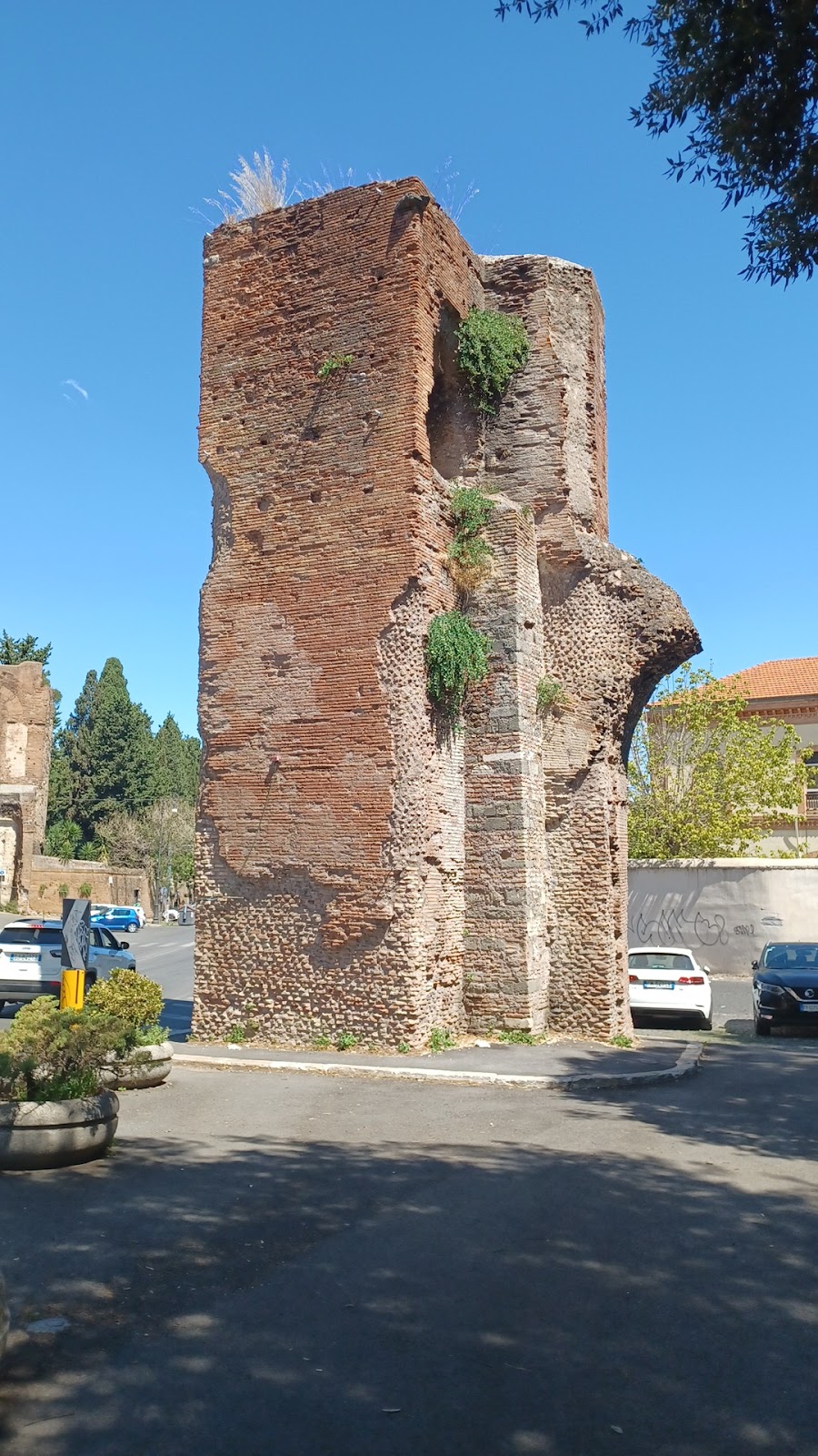
The surviving aqueduct is an elevated water-conveyance structure built chiefly from brick masonry. Its route ran from the area of Porta Maggiore across the Caelian toward the Palatine and other destinations. The original irregular alignment has largely survived, allowing the remains to be understood as parts of a connected arcade rather than as isolated fragments. Along the surviving sections, the conduit was raised above ground on brick piers and arches, including a substantial crossing of the valley between the Caelian and Palatine hills.
Route and branches
Visible remains line Via Statilia and Via di Santo Stefano Rotondo. The aqueduct also reached the Arch of Dolabella and Silanus, with its water channel passing over the ancient arch. Near Santo Stefano Rotondo, the route divided toward the Aventine, while another section continued toward the Palatine to serve the imperial residences. The surviving alignment preserves the changing direction of the ancient route as it moved between Rome’s historic hills.
Elevated arcade
Valley crossing
Where the aqueduct crossed the valley between the Caelian and Palatine, it stood on an elevated arcade, a series of arches supporting a water channel above ground. This section had two levels of arches and formed part of the structure’s highest and most substantial work. The aqueduct reached a maximum stated height of 16 m, while the conduit carried drinking water across the depression between the hills.
Street-crossing arches
The arches generally had spans of 7.75 m, supported by brick piers approximately 2.30 m long and 2.10 m thick. Where the aqueduct crossed streets, the arches were broader and more prominent. The Arch of Basilides and the Arch of Dolabella and Silanus are identified among these larger structures, with the latter also incorporated into the route of the conduit.
Brick construction and condition
The brickwork was finely executed, and the arches display an early use of skeletal brick construction, a framework-like arrangement of bricks within the arches. The structure’s final route was approximately 2 km long and included multiple tiers of arches where the ground fell between the Caelian and Palatine. The surviving arches are weathered, damp, and blackened, preserving the remains of a Roman water system alongside the lighter and more ornate architecture associated with the Palatine.