Madinat al-Zahra: The Umayyad Caliphal City near Córdoba
Site at a Glance
- Popularity
- Very High
- Country
- Spain
- Primary era
- Medieval
- Eras represented
- Classical, Medieval
- Civilizations
- Roman, Umayyad
- Site type
- City
On this page24 sections
History
Foundation and the caliphal court
Madinat al-Zahra was an Umayyad caliphal city near Córdoba, Spain, founded in 936 by Abd ar-Rahman III. A caliph was a political and religious leader of the Muslim community; Abd ar-Rahman had proclaimed himself caliph in 929. The city’s construction began between 936 and 940 and continued during the reign of his son al-Hakam II, from 961 to 976. It gave the new caliphate a court and government center designed to rival those of the Abbasid caliphs in Baghdad and the Fatimid caliphs in North Africa. The Fatimids were both political and religious rivals: they were Shia, while the Umayyads of al-Andalus, the Muslim-ruled parts of the Iberian Peninsula, were predominantly Sunni.
The name Madinat al-Zahra has been interpreted as Radiant City or Flowering City. It may have echoed names used for other caliphal cities or answered the Fatimids’ claim of descent from Fatimah, the daughter of Muhammad, whose title az-Zahra means the Radiant. A popular story instead links the name to Abd ar-Rahman’s favorite wife and describes a statue of her above an entrance, though the statue is considered unlikely to have existed.
Al-Hakam, then crown prince, supervised the building work. A writer of the 16th century credited the design to Maslama ibn Abdallah, but his precise contribution is uncertain. Work proceeded in stages, with the city’s plan changing as construction advanced. The court moved to Madinat al-Zahra in 945, the road to Córdoba was paved the following year, and the state administration, including the mint, transferred there in 947. Both caliphs continued building, with senior officials also taking part.
Expansion and political change
A major remodelling in the 950s replaced many earlier, smaller buildings with larger, more imposing structures. This shift coincided with Abd ar-Rahman III’s reorganization of the state in 955 and his increasing awareness of Fatimid and Byzantine court architecture and ceremony. The vizier Abdallah ibn Badr supervised construction of the Reception Hall of Abd ar-Rahman III. The caliph’s servant Shunaif oversaw its decoration, though his involvement in its design is unclear.
After al-Hakam II died in 976, effective authority passed to Ibn Abi Amir, known as al-Mansur or Almanzor. In 978–979, Almanzor began a rival palace-city, Madinat al-Zahira. When its construction was complete about two years later, he transferred the government there. Madinat al-Zahra was no longer the seat of government, and Almanzor kept the young caliph Hisham II in Córdoba’s old palace precinct.
Civil war and destruction
Following Almanzor’s death in 1002, his son Abd al-Rahman, known as Sanchuelo, attempted to claim the caliphate from Hisham II. In February 1009, while Sanchuelo was away on campaign, his opponents forced Hisham to abdicate. The resulting Fitna, a civil war that fractured the Caliphate of Córdoba in the early 11th century, brought the destruction and sack of Madinat al-Zahra between 1010 and 1013, during a siege of Córdoba by Berber factions. People continued to take building materials from the ruins for centuries. Earthquakes in the 10th and 11th centuries may also have damaged and brought down parts of the palace complex.
Rediscovery and modern history
As the ruins became buried, their location faded from memory. In the Middle Ages, the hillside later called Córdoba la Vieja was mistakenly identified as the site of an early Roman Córdoba. Humanists debated the remains’ origins from the 16th century onward. In the 17th century, Pedro Díaz de Rivas argued that they belonged to Abd ar-Rahman III’s palace-city rather than a Roman settlement. The site was identified again in the 19th century.
Excavation began in 1911 under architect Ricardo Velázquez Bosco. Félix Hernández Giménez led work from 1923 to 1936 and again from 1943 to 1975, excavating the central palace area and carrying out major restoration. Archaeological campaigns resumed after the Spanish Civil War, including work from 1944. Rafael Manzano Martos directed the site from 1975 to 1982, Antonio Vallejo Triano from 1985 to 2013, and José Escudero Aranda from 2013. Management passed to the Government of Andalusia in 1985.
Since 2007, archaeological work has extended beyond the palace precinct, prompting revisions to ideas about the city’s extent and layout. The excavated remains represent only a small part of the city, and illegal housing construction has threatened unexcavated areas. In 2005, Córdoba’s local government appears not to have enforced a 1995 law that extended protection against development. The site became a Spanish cultural monument in 1923 and was inscribed by UNESCO in 2018 as the Caliphate City of Medina Azahara. A low-profile archaeological museum, built partly underground at the edge of the site to reduce its visual impact on the ruins and landscape, received the Aga Khan Award for Architecture in 2010.
Madinat al-Zahra helped shape Andalusi Islamic architecture and a distinctive 10th-century caliphal style. Its reception halls and divided, terraced gardens became influential in later palace design in al-Andalus and beyond. During the Spanish Civil War, part of the site known as Suerte Chica served as a Francoist concentration camp from February until late November 1939, holding about 4,000 prisoners. The area later became known locally as Suerte de los Prisioneros.
Remains
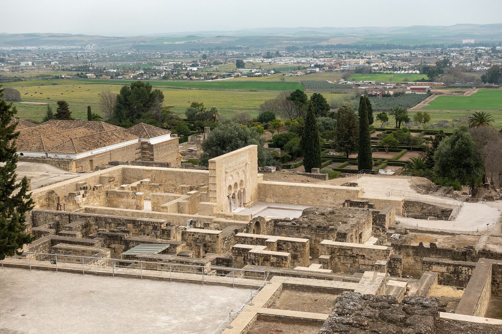
The city covered about 112 hectares in an approximately rectangular area, roughly 1,500 metres from east to west and 750 metres from north to south. Its northern boundary followed the terrain rather than a regular line. The site occupies the slope of Jabal al-Arus in the foothills of the Sierra Morena, facing the Guadalquivir valley. Three walled terraces stepped down the slope: the caliph’s residence occupied the highest level, official buildings and elite homes the middle, and the town and its public facilities the lower. The palace precinct, or Alcázar, was divided broadly between official and reception buildings in the east and residential areas in the west. Its terraces and position gave it a commanding physical and visual relationship to the lower city and plain.
City walls and entrances
A thick stone wall with square towers enclosed the city, while another wall separated the palace precinct from the lower town. The palace enclosures appear to have been built before the outer city wall, as residential areas developed beyond them. The city’s northernmost point, near its highest ground at 215 metres above sea level, stood about 70 metres above its southern edge. In the central north, terrace levels differed by 10 metres or more. The lower city included a western military zone about 200 metres wide, a central garden and orchard area about 600 metres wide, and an eastern urban zone about 700 metres wide. Open ground along the palace precinct’s southern side maintained its separation from the lower city.
The northern city gate was Bab al-Jibal, or the North Gate. Bab al-Qubba stood in the middle of the southern wall, and Bab al-Shams was set into the eastern wall. The palace’s official eastern entrance, Bab al-Sudda, faced a large esplanade used for ceremonies, military parades, and executions.
North Gate
At the northern end of the road to Córdoba, the North Gate had a passage that turned before reaching the interior, a defensive tower, and a guardroom controlling access. Its stonework, like that of the city wall, used carefully cut blocks laid in alternating orientations.
Palace entrance portico
The monumental portico at Bab al-Sudda had a viewing platform above it, and a ramped street led from the gate toward the Upper Basilical Hall. Originally, the portico had fifteen arches: a central horseshoe-shaped arch, whose sides curve inward below their widest point, and fourteen segmental arches. Several arches on the northern side were later removed. The structure measured about 111.27 metres long, 2.92 metres wide, and 9.46 metres high.
Palace halls and reception spaces
Upper Basilical Hall
Near the northeastern part of the excavated palace, west of Bab al-Sudda, the Upper Basilical Hall has been tentatively identified as the Dar al-Jund, or House of the Army. Its function remains uncertain: it may have served as an administrative or ceremonial reception hall, a meeting place for army officers, or the main audience hall. Its northern block was joined to a courtyard on the south. That courtyard measured 54.5 by 51 metres and had narrow porticoes along its eastern and western sides. Its remains were turned into a garden in the 1960s.
A broad, gently sloping ramp led to the hall, bending several times and incorporating benches. It was wide enough for people to approach on horseback. Raised above the courtyard, the main building contained five parallel chambers, each about 20 metres long, with a sixth room crossing their southern ends. The complex could accommodate up to 3,000 people and forms the largest interior space recorded in historic palace architecture in the western Islamic world. Plastered stone walls had a red lower decorative band, called a dado, and the floors were brick. Carved column capitals supplied much of the ornament; tapestries or curtains may have covered the walls or arches.
Reception Hall of Abd ar-Rahman III
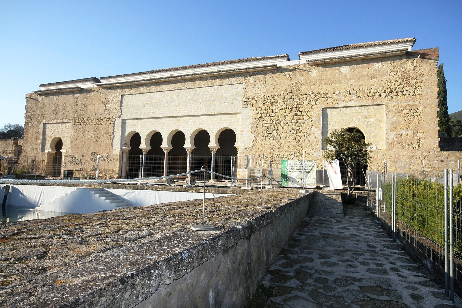
Built between 953 and 957, the Reception Hall of Abd ar-Rahman III, also called the Rich Hall, stood on a raised platform south of the Upper Basilical Hall. Ramps provided access. The hall faced across a garden toward a large water basin, and its five-arched front aligned with the basin. It measured about 38 by 28 metres externally. Inside, a crosswise entrance hall led to a central space divided into three long parallel sections, with rooms on either side. The central hall measured 17.5 by 20.4 metres; its arches and blind arches framed the setting for audiences.
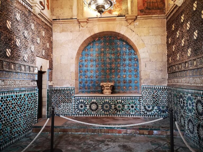
Marble was used for the columns and floor, while the carved wall panels were mainly limestone. The ornament includes alternating wedge-shaped arch blocks, framed by rectangular mouldings, and flowing plant patterns, especially tree-of-life designs. The original ceiling form is unknown. The hall has been reconstructed, and work to restore its decoration has continued.
Residences and palace courts
Royal House
The Dar al-Mulk, or Royal House, is tentatively identified with a building on the city’s highest terrace and was among the site’s earliest structures. Its main block had three parallel halls entered from the south, with smaller rooms on either side. The southern hall has been lost, while the other two have been partly reconstructed. An adjoining apartment included a courtyard, an arched portico, and a hall; it was built over an earlier bathhouse. The south-facing front had decorated doorways, geometric and plant carving, patterned floors, and a blind arcade, a row of arches set against a wall. A staircase descended from the terrace. A private bath was destroyed after 961, and in 972 the building was reused to educate Prince Hisham, the future successor of al-Hakam II.
House of Ja’far
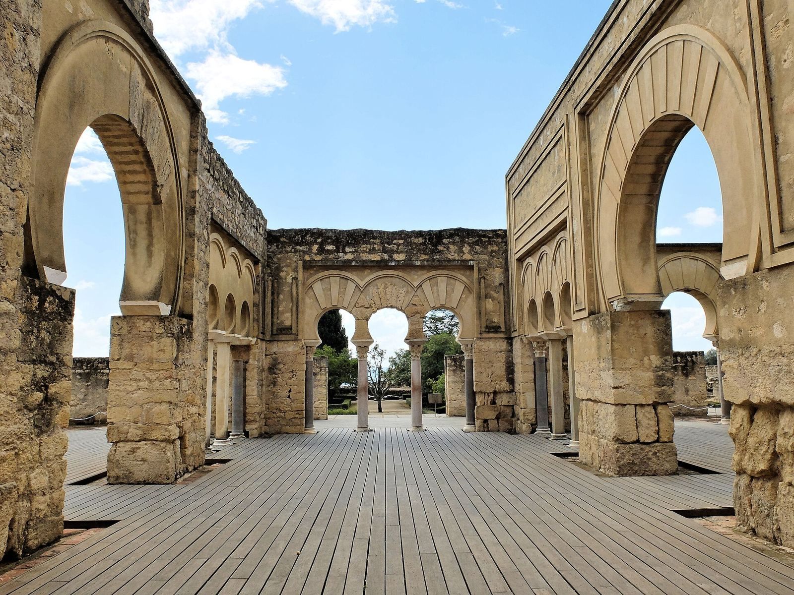
Built after 961 during al-Hakam II’s reign, the House of Ja’far occupies the space between the Court of the Pillars and the Reception Hall, over the remains of three earlier houses. Its identification as the residence of Ja’far al-Siqlabi, a senior court official, is uncertain. Three courtyard areas served official, private, and service purposes. The reception area had a basilica-form plan, meaning a long hall divided into parallel sections, crossed by a transverse hall. A portico of three horseshoe arches stood at its entrance.
White marble paved the floors except in the courtyard, where violet limestone was used. Plant and geometric patterns were carved on the front and some doorways. A surviving staircase suggests that the house may have had a second storey. Restoration beginning in 1996 reconstructed its monumental portico and recovered more than 200 paving slabs, wall paintings, a basin, and the façade.
House of the Water Basin
South of the Court of the Pillars and west of the House of Ja’far, the House of the Water Basin is thought to belong to the city’s early building phase, although parts of its plan were later altered. Its square courtyard contained two sunken gardens and a basin on the western side. Walkways and water channels crossed the courtyard, where plants included lavender, oleander, myrtle, basil, and celery. Decorated arcades of three arches gave access to the main halls.
Behind the eastern rooms lay a private bath with three chambers arranged from largest to smallest. An underfloor heating system warmed the rooms beneath their marble floors, and marble decoration was added to the bath in 961–962. The bath has been investigated as part of work preparing the building for possible restoration.
Court of the Pillars
Southeast of the Royal House, the Court of the Pillars was built over earlier, smaller structures. A large square courtyard sat within a portico, with broad halls on three sides. A staircase in the northwest corner led to an upper storey arranged on a similar plan. Roman sculptures were found in the court, including fragments of a stone coffin known as the Sarcophagus of Meleager. The sarcophagus has been reconstructed and is kept at the site. Roman sculptures were also associated with the nearby Court of the Clocks.
Gardens and water features
Upper Garden
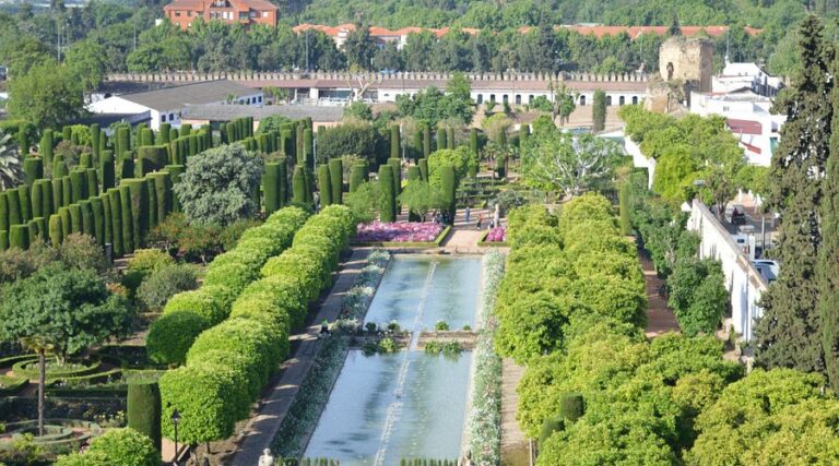
The Upper Garden occupied an artificial terrace in front of the Rich Hall, about 10 metres above the surrounding ground. The Lower Garden lay to its east and the mosque to its west. The Upper Garden reached a final width of 153.5 metres after extending over part of the Lower Garden; the initially intended square may have measured 133 metres on each side. Paths divided it into four slightly unequal planting areas, with a perimeter path about four metres wide. The planting beds lay 50 to 70 centimetres below the paths. Remains of planting include myrtle, lavender, hackberry, oleander, basil, alexanders, jujube, and heather.
A basin on the garden’s northern side measured 19 by 19 metres and was two metres deep. The ground sloped gently south, and channels along the paths distributed water. The Central Pavilion, dated to 956 or 957, stood on a platform and contained three parallel halls. A small basin lay on each of its four sides; these pools may have reflected the buildings and sky.
Lower Garden
South of the Royal House and east of the Upper Garden, the Lower Garden has been only partly excavated. It followed a four-part design, with paths about four metres wide and sunken planting beds. It originally measured about 125 metres from north to south and 180 metres from east to west. Its width was reduced by 22 metres when the Upper Garden was built. A large support on the Upper Garden’s eastern side had a basin at its foot; a pavilion above it is possible but unconfirmed. Together, the two gardens are among the earliest excavated examples of four-part Islamic gardens, known in Persian as a chahar bagh, or garden divided into four parts.
Religious buildings
Main congregational mosque
The main mosque stood on the lower level, east of the Upper Garden and outside the palace precinct. A covered passage through the garden’s eastern wall linked it to the palace. The mosque measured about 25 by 18 metres and was oriented northwest to southeast toward the qibla, the direction of prayer toward Mecca. Its courtyard occupied the northwest end, with the prayer hall to the southeast. Facilities for washing before prayer stood near the entrance. Three gates opened into the courtyard, and a square-based minaret beside the main entrance originally rose about 20 metres.
Two tiers of arches divided the prayer hall into five parallel sections, with the central one wider than the others. A private passage allowed the caliph to reach the maqsura, a reserved area near the mihrab, the niche marking the direction of prayer. The mosque was built between 941 and 945.
Neighbourhood mosque
A smaller mosque has been identified in the southeastern part of the city. Its remains form part of Madinat al-Zahra’s religious architecture.
Infrastructure and materials
Water reached the palace’s higher levels through a new branch from a Roman aqueduct that had carried water from the Sierra Morena to Córdoba. The diverted section of the old aqueduct was reused as a main sewer, linked to smaller drainage channels. Two bridges associated with newly built roads survive. Limestone from a nearby quarry was the principal building stone, with other stone obtained from within about 50 kilometres. Abd ar-Rahman III procured or imported antique marble columns, chiefly from Ifriqiya, for reuse. Al-Hakam II also obtained Roman statues and carved stone coffins for the city’s decoration.
Several roads linked the city to Córdoba and the surrounding region. The direct Camino de las Almunias connected Córdoba with Madinat al-Zahra and routes toward Seville and elsewhere. The Camino de Media Ladera joined the Córdoba–Badajoz road; about one kilometre of it survives, measuring four to seven metres wide. The Camino de los Nogales–Carril de los Toros provided access to eastern routes without passing through Córdoba, while the secondary Camino del Oeste linked the city to western agricultural estates.
Two large complexes stood outside but close to the city: a villa at the center of an agricultural estate, later given to the state treasurer, and Turruñuelos, a large rectangular structure that may have served as barracks. The excavated remains reveal characteristic arch forms, framed arches, carved plant ornament, and reception halls divided into parallel spaces, alongside the city’s carefully tiered layout and gardens.