Lagarde Fort: A Seventeenth-Century Frontier Citadel in France


Site at a Glance
- Rating
- 4.5
- Popularity
- Low
- Country
- France
- Primary era
- Early Modern
- External website
- Open
- Eras represented
- Medieval, Early Modern
- Civilizations
- Crown of Aragon, French
- Site type
- Military
- Remains
- Fort
On this page14 sections
History
Lagarde Fort is a seventeenth-century French citadel above Prats-de-Mollo-la-Preste in France, built under Louis XIV to protect the town, watch the Col d’Ares route into Spain, and control access to the upper Vallespir. Its construction followed the 1659 Treaty of the Pyrenees, which transferred Roussillon, Vallespir, Conflent, Capcir, and part of Cerdanya to France, making Prats-de-Mollo a strategic frontier position approximately 13 kilometres from the Spanish border.
Medieval Watchtower and Frontier Setting
Prats-de-Mollo had been divided by the Tech into northern and southern parts since the thirteenth century. The town occupied the northern side, while a medieval castle on the opposite bank served as a residence of the counts of Besalú. Under Aragonese rule, a watch and signal tower stood at the future fort site. In 1307 it was known as Lagardia, or the Tower of la Guardia, and stood at an altitude of 1,540 metres.
The tower formed part of a warning network. Its garrison transmitted military signals by fire at night and smoke by day, communicating with the towers of En Mir and Cos. This earlier defensive role explains why the round tower was later retained at the centre of the new citadel.
Revolt and French Consolidation
The fortifications gained new importance after the Angelets de la Terra revolt, an uprising in Vallespir and Conflent against the reintroduction of the gabelle, the French salt tax. The tax had been abolished in the area since 1292, and its return helped provoke resistance between 1663 and 1672. Josep de la Trinxeria, a native of Prats-de-Mollo, was one of the revolt’s leaders.
After the siege of Prats-de-Mollo in 1670, the medieval Château de Perella, also called Périlloux, was strengthened. It accommodated about 100 soldiers and artillery, with the purpose of monitoring the population. Six years later, this earlier fortification was dismantled in favour of the present fort. The new citadel was intended both to defend the recently established frontier with Spain and to discourage renewed opposition to the annexation of the northern Catalan counties.
Construction under Vauban
The Dutch War of 1672 to 1678 increased the danger of a Spanish attack and prompted major development at Lagarde. The star-shaped central work was built around the medieval signal tower in 1677. Most construction followed the directives of Sébastien Le Prestre de Vauban, Louis XIV’s chief military engineer and commissioner-general of fortifications. Vauban applied systematic bastioned designs that used projecting works to resist artillery and coordinate defensive fire.
Christian Rousselot de Monceaux prepared the overall plans. Vauban revised them during his visit to Prats-de-Mollo in 1679, and the keep was completed under his direction in 1686. In 1691, Rousselot prepared an enlargement based on Vauban’s plans, which Vauban supported before the king. War and inadequate funds interrupted the proposal. Construction continued broadly until the mid-eighteenth century, while further changes were made until the end of the nineteenth century.
War, Decommissioning, and Restoration
Lagarde Fort changed hands during the War of Roussillon, the 1793 to 1794 conflict between revolutionary France and Spain in the eastern Pyrenees. In 1793, General Antonio Ricardos advanced through the Col d’Ares and Spanish forces quickly captured the fort. It remained under Spanish control until 1794, when French troops led by General Jacques François Dugommier drove the Spanish back across the Pyrenees.
The fort ceased to be a military property in 1926. It had already received protection as a French historical monument in 1925. The municipality acquired it in 1976 and undertook its restoration.
Remains
Mountain Citadel and Defensive Layout
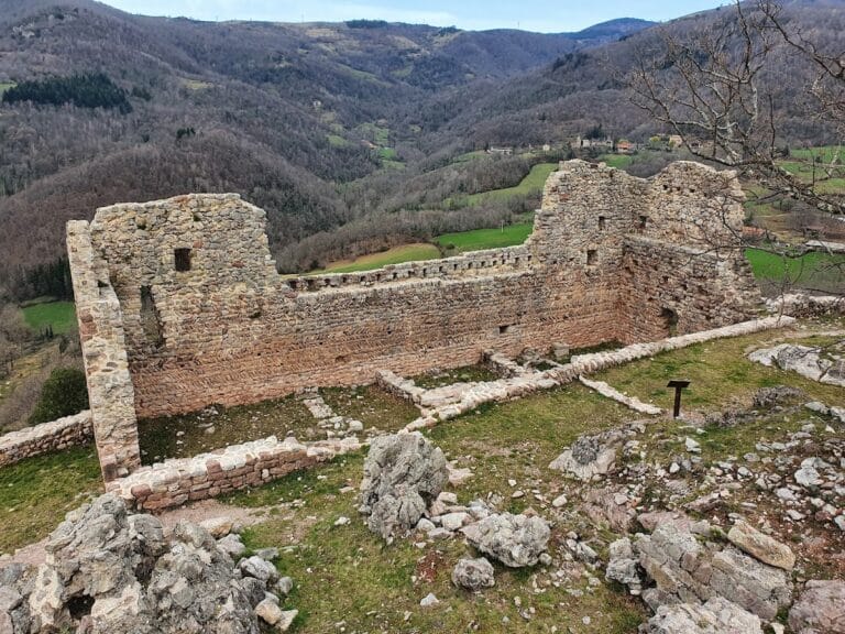
Lagarde Fort adapts bastioned fortification to the steep mountain terrain above Prats-de-Mollo. Its central work has a star-shaped plan and incorporates the earlier round signal tower. Granite from the Costabonne massif, schist, and brick form the principal construction materials. The planned fortification remained incomplete, leaving its capacity at approximately half the level originally envisaged by Vauban.
Central Work and Signal Tower
The round medieval signal tower survives at the centre of the star-shaped central work. Once used to transmit warnings by fire and smoke, it became part of the artillery fortification created from 1677 onward. The keep, completed in 1686, belongs to the later development directed by Vauban.
Southern Defensive Lines
Two defensive lines extend south of the central work. The first is a counterguard, a projecting work intended to shield the main fortification from artillery. The second combines a lower rampart called a fausse-braie, the Sainte-Marguerite redan, and the right-hand cornice. The wall rises higher from the bastion towards the east because of the ground.
Eastern and Western Fronts
Ravines border the northern and eastern fronts, while the eastern side also includes an advanced system of earthworks. The western front was treated as the most vulnerable and received a complex defensive arrangement with a place of arms and a traverse known as the Tomb of Mahomet. Its name probably refers to the resemblance of its form to a Muslim tomb.
Southeastern Hornwork
A hornwork, an outward defensive position formed by angled walls, was attached to the central work on the southeast side. The structure contained a building and extended the fort’s defensive system beyond the main star-shaped enclosure.
Town Connection and Underground Route
The fort’s materials, provisions, and other supplies reached the site from the town along a narrow path, carried by people or mules. A parallel military retreat route served the same connection. These routes linked the mountain position with the settlement below while preserving a separate means of movement for military purposes.
Underground Passage
An underground passage from the eighteenth century links Lagarde Fort with Prats-de-Mollo. It contains 142 steps and leads to an advanced redoubt, a small enclosed defensive work, with machicolations on an arch. This structure is also called the Square Tower.
Covered Way and Redoubt
A covered way, a protected military passage between defensive works, connects the town with the redoubt. It completed the route by which soldiers stationed in Prats-de-Mollo could reach the fort during an attack or blockade. The underground route emerges several dozen metres from the town’s ramparts.
Nearby sites