Kanka: An Ancient Urban Center in Uzbekistan
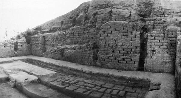
Site at a Glance
- Rating
- 4.8
- Popularity
- Very Low
- Country
- Uzbekistan
- Primary era
- Classical
- Eras represented
- Classical, Medieval
- Civilizations
- Seleucid
- Site type
- City
On this page15 sections
History
Kanka is an ancient urban settlement in Uzbekistan, in the Akkurgan District of the Tashkent oasis, whose earliest phases date to the late fourth or third century BCE. The city continued in use until the thirteenth century CE and became one of the oldest major urban centers in the oasis, traditionally regarded as its first capital.
Early settlement and the Antiochia identification
Kanka’s earliest occupation and construction belong to the late fourth through second centuries BCE. The settlement is commonly identified with Antiochia on the Jaxartes, a city mentioned in ancient sources, although this remains an archaeological interpretation rather than an established fact.
According to the historical reconstruction behind that identification, the Seleucid commander Demodam crossed the Syr Darya in 293 BCE during a reconnaissance and demonstration of military power against the Saka living beyond the river. He negotiated a boundary with them, raised an altar to Apollo Didymaios, and fortified a city named Antiochia in honor of Antiochus I Soter, the Seleucid ruler of the empire’s eastern territories. The proposed connection between this campaign and Kanka depends on relating those events to the site’s earliest archaeological layers.
Kanguy, Shash, and Kharashkat
The settlement later became part of the Kanguy state, an ancient Central Asian polity known especially through Chinese historical records. It is thought to have served as the first capital of Shash, also called Chach, the historical name of the region around the Tashkent oasis. Chinese records identify the city with Yuni, while medieval Arabic geographical and travel writings call it Kharashkat.
Kharashkat occupied an important position on the northern route of the Great Silk Road. In the medieval period, its name was associated with the meanings “City of Royal Favor” and “City of Holy Farna.” Ibn Hawqal described it as the second-largest city of Shash after Binkat. Farna was an Iranian idea of divine or royal fortune and legitimacy, giving the name a political and religious association.
The origin of the name Kanka remains disputed. Proposed explanations connect it with Kangha, described in the Avesta as a high and sacred place; with traditions about Afrasiab in the Shahnameh; with a legendary king called Kanka or Anka; with qon, meaning “blood,” in the sense of a bloody or sacrificial place; or with the historical Kanguy state.
Later urban phases and archaeological study
Kanka remained an urban center through successive periods. Later buildings belong to the sixth and seventh centuries CE and to the eleventh and twelfth centuries. The settlement’s long history ended in the thirteenth century, after which its physical remains preserved evidence of changing political, religious, residential, commercial, and productive activity.
Investigation began with an inspection by the Chatkal-Kurama archaeological expedition in 1966. Excavations followed in 1969–1972 under K. Abdullaev, conducted by the State Administration for the Protection of Material-Culture Monuments. Since 1974, the Institute of Archaeology of the Academy of Sciences of Uzbekistan has studied Kanka as one of its principal research locations. Further smaller investigations were carried out by the archaeology department of the National University in 2007–2008 and in 2012. The site was also studied and described by an expedition led by the archaeologist and academician Yuri Buryakov.
These investigations established Kanka as an important historical and cultural monument of the region. In September 2023, international specialists observed that parts of the archaeological site had been occupied by local residents and seriously damaged. Kanka was added to the UNESCO World Heritage Tentative List in the cultural category on 18 January 2008.
Remains
Overall layout and defenses
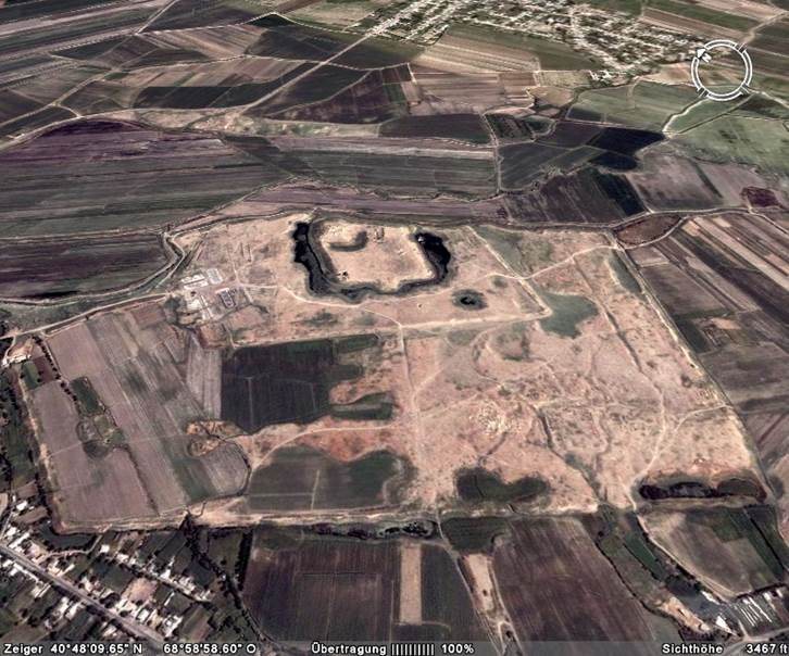
Kanka lies on the left bank of the Karasu channel, the former bed of the Akhangaran River, near its former confluence with the Syr Darya. The remains spread across a large mound-like area among cultivated fields. The settlement covers approximately 500 hectares, while the fortified urban territory enclosed by the principal walls covered about 160 hectares and was protected by three rows of walls.
Unlike the common Central Asian arrangement of a citadel, one main city sector, and an outer suburb, Kanka consisted of three nested shahristans. A shahristan was the principal urban sector of a Central Asian city. Each was defended on three sides by substantial fortifications, while the high riverbank formed their shared boundary on the fourth side and was also accompanied by a wall.
Citadel
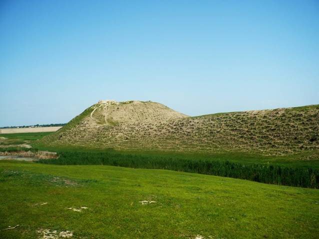
The citadel rises on an elevated mound approximately 50 metres above the surrounding ground. A large crescent-shaped ditch surrounds it, retaining groundwater and rainwater and forming a marsh around the citadel remains. A route to the summit begins at a narrow isthmus and follows the steep slope in a geometrically regular spiral. Another description places the citadel’s only entrance at the center of its northern facade.
The citadel contained a ruler’s palace, a domestic fire temple, and a large castle structure with four towers. The castle stood on a substantial platform built in nine layers of pahsa, or compacted adobe clay, with earlier buildings concealed within it. Upper layers contained buildings from the sixth and seventh centuries CE and from the eleventh and twelfth centuries. A summit temple indicates the maintenance of a sacred fire, while the citadel also held a palace associated with a fire temple. Fire temples were Iranian religious buildings centered on the care of a sacred fire.
Nested shahristans
Shahristan I
Shahristan I occupied the northwestern part of the settlement and followed a regular quadrangular plan extending westward from the river. Its fortification walls rose about 26 metres from their base and were accompanied by a ditch approximately 35 metres wide. The only gate stood at the center of the southern side, where a tower apparently supported a drawbridge.
Cultural deposits within Shahristan I reach approximately 20 metres, and an excavation in its western sector recorded deposits up to 26 metres thick. The earliest dwellings stood near the fortification wall and were semi-subterranean houses. Later, these were replaced by substantial buildings above ground. The earliest construction horizons date from the late fourth to the second century BCE, and pottery from the semi-subterranean houses was dominated by professionally wheel-made vessels comparable to contemporary Sogdian ceramics.
The defenses of Shahristan I included double walls, towers, loopholes, and a two-level passage within the wall. An outward-projecting berm strengthened the base and made it harder for siege engines and battering machines to approach.
Shahristan II
Shahristan II surrounded Shahristan I on three sides and followed a square plan along the riverbed. It covered approximately 45 hectares, had compact internal planning, and possessed its own fortification wall. Its separation from the earlier urban sector resulted from a temporary contraction of the settlement at the beginning of the seventh century CE.
Shahristan III
Shahristan III enclosed the other urban areas and had a plan approaching a trapezoid. Its fortified territory covered approximately 160 hectares and was preceded by a terrace and a small ditch. Streets and bazaar squares densely occupied its southwestern and central sectors. Production workshops and a city caravanserai were found in the western and northeastern sectors, where the archaeological layout included these functional areas.
Outer settlement and civic spaces
Rabad
The rabad, the outer suburb commonly associated with trade and craft activity, extended in a horseshoe shape east and southwest of the fortified urban territory. Much of this area has been ploughed, and the character of its own fortifications remains uncertain.
Residential, market, and production areas
Archaeological work revealed residential quarters, industrial workshops, bazaar squares, and a large monumental caravanserai. The site also included a small urban settlement with a suspension bridge. Together, these features preserve the organization of domestic, productive, commercial, and transport-related spaces around the fortified city.
Religious objects and structures
Terracotta figurines from Kanka represent the fertility and water goddess Anahita, a boar, and rams. One ram has been interpreted as an image of the life-giving power of Solar Favor, or Farna. The boar may relate to Verethragna, an Iranian deity associated with victory and martial power, and to the protection of the solar-associated deity Mithra. These interpretations remain uncertain.
Remains associated with Manichaean religion were also reported, including monumental temple-related elements and bull-type imagery. The identification and precise nature of all these objects remain uncertain, while the temples, dwellings, defenses, streets, workshops, caravanserai, and market spaces together represent the settlement’s successive urban phases.