Kamianets-Podilskyi Castle: A Medieval Frontier Fortress in Ukraine


Site at a Glance
- Rating
- 4.8
- Popularity
- Very High
- Country
- Ukraine
- Primary era
- Medieval
- External website
- Open
- Eras represented
- Medieval, Early Modern
- Civilizations
- Grand Duchy of Lithuania, Kievan Rus, Kingdom of Poland, Ottoman, Polish–Lithuanian Commonwealth
- Site type
- Military
- Remains
- Castle
On this page22 sections
History
Kamianets-Podilskyi Castle is a medieval fortress in Kamianets-Podilskyi, Ukraine, built and expanded over many centuries as part of the city’s defensive system. It stood within Podolia, a historical region of eastern Europe, and was associated with the Podolian Principality, the Podolian Voivodeship, and later the Podolian Governorate. Its beginnings are debated, but archaeological and architectural research places the earliest castle development between the eleventh and thirteenth centuries. The fortress later protected a strategic transport crossroads and served as a frontier defense from the fourteenth to the eighteenth century.
Early foundations and princely rule
The castle’s foundation was traditionally assigned to the second half of the fourteenth century. Investigations carried out from the 1960s onward instead placed its origins in the eleventh and twelfth centuries, or possibly the late twelfth to early thirteenth century. An earlier earthwork from the period of Kyivan Rus, the medieval East Slavic political and cultural world, existed in the wider area but not on the exact site of the present fortress. A proposed Dacian-Roman origin in the second or third century remains disputed.
The first precise written reference dates to 1374. In a document issued by Prince Yuri Koriatovich with the consent of his brother Alexander Koriatovich, Kamianets was granted Magdeburg rights, medieval municipal privileges based on Magdeburg law. The document stated that it was issued “at the castle,” placing the fortress within the political and administrative life of the city by that date.
The complex developed through approximately fourteen construction phases between the eleventh century and the beginning of the nineteenth century. In 1393, Vytautas captured the fortress during disputes within its garrison. In the early fifteenth century, Spytek II of Melsztyn, voivode of Krakow, began modernizing the aging defenses to protect Kamianets and nearby trade routes. Older towers were repaired and ten new towers were added.
Sixteenth-century modernization and frontier warfare
The castle’s appearance most closely resembling its present form was established during major works in the mid-sixteenth century. These were directed by the military engineer and architect Hiob Pretfus, also known as Job Pretvich. He was responsible for the New Western and New Eastern towers, the eastern castle wall, an underground gallery, entrances, and housing for personnel serving the city starosta, a royal or state official who administered a district or royal estate.
In 1502, Stanislaw Chodecki worked to improve the fortress’s fortifications, armament, and ammunition. He was among the commanders who defended it successfully against the forces of the Moldavian ruler Bogdan III in 1509. The fortress endured repeated attacks during the period when the Polish-Lithuanian Commonwealth ruled much of the region. Tatar forces attacked it 51 times between the fifteenth and seventeenth centuries. Assaults in 1448, 1451, 1509, and 1528, as well as the Ottoman siege of 1533, damaged the castle and city but were repelled.
The fortress was besieged by Sultan Osman II in 1621. During the Khmelnytsky Uprising of 1648 to 1654, a revolt led by Hetman Bohdan Khmelnytsky against the Polish-Lithuanian Commonwealth, local Cossacks and insurgents led by Maksym Kryvonis attacked it without success. Forces led by Hetman Ivan Bohun besieged it again in 1651, and Bohdan Khmelnytsky’s army brought the castle under Cossack control in 1652. A Crimean Tatar force attacked it once more in 1653.
Ottoman occupation and return to Polish rule
In August 1672, Ottoman forces led by Sultan Mehmed IV, supported by Tatars and Cossacks commanded by Hetman Petro Doroshenko, besieged the fortress. The city leaders surrendered on 18 August. During the siege, the New Tower was destroyed by a gunpowder explosion whose circumstances remained uncertain. Tradition associated the blast with the deaths of the fortress commander, Major Hejking, and approximately 800 defenders.
The Ottoman Empire, the multinational state that controlled Podolia from 1672 to 1699, repaired the damaged tower and made Kamianets the center of its Podolian administration for 27 years. Polish control returned after the 1699 Treaty of Karlowitz, the peace settlement that ended Ottoman territorial control in much of Central Europe and returned Podolia to Polish rule. From 1699 to 1793, the fortress was governed by specially appointed commanders.
Prison, Russian rule, and political history
From the beginning of the eighteenth century, the castle progressively lost its defensive role and became a military prison. A Russian Imperial garrison occupied it in 1812, and the fortress was formally abolished that year. From 1816 to 1914 it also held debtors, criminals, and political prisoners. In 1815, the officer Konstantin Batyushkov was stationed there. In 1846, Vladimir Rayevsky served at the castle and established a pro-Decembrist organization of military officers. Decembrists were Russian officers and political reformers associated with the failed December 1825 uprising against imperial rule.
The castle and city passed under Russian sovereignty on 21 April 1793 after the Second Partition of Poland. Russian authorities subsequently neglected the fortress’s preservation, although a tax introduced in 1840 was intended to finance its conversion into a prison. The castle also became associated with the nineteenth-century anti-feudal movement in Podolia led by Ustym Karmaliuk, who was imprisoned there and later regarded as a Ukrainian national folk hero. Vladimir Dal worked at the castle in 1831 while compiling a Russian-language dictionary.
After the 1905 Revolution, political organizations were permitted to operate in the castle. In 1906, 67 organizations were based there, including Iskra, the newspaper of the Russian Social Democratic Labour Party.
Preservation and modern interpretation
A decree of the Ukrainian Soviet government declared the castle complex a historical-cultural preserve in 1928. Museum conversion was planned in the late 1930s, and reconstruction began in 1937. The castle entered the all-Union list of historical preserves in 1947.
Restoration and archaeological work began under the supervision of the architects Yevheniia Plamenytska and Anatolii Tiupych in 1962. Architectural investigations from 1964 to 1982 and archaeological work from 1964 to 1969 greatly expanded knowledge of the fortress’s early history. The National Historical-Architectural Reserve “Kamianets” was established in 1977, received national status in 1998, and was upgraded to a national conservation district in 2004. The castle and Old Town were placed on Ukraine’s UNESCO World Heritage tentative list in 1989, and the complex was named one of the Seven Wonders of Ukraine in 2007.
The fortress is administered as part of the Kamianets-Podilskyi State Historical Museum-Reserve and the National Historical-Architectural Reserve “Kamianets.” It lies within Podilski Tovtry National Nature Park and is listed in Ukraine’s State Register of Immovable Monuments. A severe storm on 1 August 2011 partially collapsed the New Western Tower. The city mayor’s office did not reject the possibility that reconstruction work in 2007 had weakened its structural integrity.
Remains
The fortress occupies a limestone formation and peninsula enclosed by the looping Smotrych River and its canyon. A narrow rocky ridge connects the peninsula with the Old Town, and the Castle Bridge crosses this approach. The complex consists of the Old Castle, a masonry fortress of walls and towers, and the New Castle, an early-seventeenth-century earthwork fortification built according to the bastion system. The Old Castle protected the approach from the Old Town and direct assaults, while the New Castle was designed to resist field armies and long-range artillery.
Old Castle and defensive walls
Old Castle layout
The Old Castle has an irregular quadrilateral plan extending from southeast to northwest along the edge of a high rocky promontory. It is approximately 50 metres wide, 135 metres long on the northern side, 160 metres long on the southern side, and 180 metres across the center. Its courtyard covers approximately three-quarters of a hectare, while the area including adjoining buildings is about 1.5 hectares.
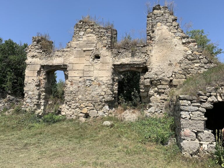
High walls surround the Old Castle, which is described as having eleven masonry towers. Four towers stand along each long side, two joined towers occupy the western end, and one separate tower stands on the northern side near the river. The principal complex had twelve major towers at its fullest extent, while smaller associated structures included a southern tower, two towers attributed in one interpretation to a Dacian-Roman phase, and a half-tower at the western end of the Castle Bridge. Some towers remain intact.
Wall sectors and northern defenses
The northern, southern, and eastern walls formed the principal wall sectors. The northern walls extend for approximately 336 metres and protect the inner courtyard. Their northwestern section contains two parallel walls incorporating the New Western Tower, the remains of the Black Tower, and a two-level casemate, a fortified chamber for troops, storage, or protected artillery.
The oldest northern wall dates to the beginning of the twelfth century and retains battlements. The Northern Bastion was constructed in 1790, before the Second Partition of Poland, to reinforce this side. The surviving northwestern walls rise approximately 13.7 metres above the exterior ground and 5.7 metres above the courtyard. Their thickness changed through successive rebuilding phases, from approximately 1.45 metres in the medieval period to 2.2 metres in the fourteenth and fifteenth centuries, and to an average of four metres after reconstruction in the sixteenth and seventeenth centuries.
Investigations of the walls exposed foundations on limestone above the river valley, extending westward and from the Old Castle toward the New Castle ramparts. They included supports for an earlier castle bridge and a wall approximately 2.5 metres wide and five metres high.
New Castle earthworks
The New Castle is a trapezoidal hornwork, an outlying fortification formed by projecting ramparts, northwest of the Old Castle. Its broad side faces northwest, while its narrow side adjoins the older fortress. Double earth ramparts enclose broad, deep, stone-lined ditches. Gunpowder cellars and casemates for personnel and stores were built beneath the earthworks, which are partly preserved.
Including its ramparts, the New Castle measures approximately 250 metres across and 220 metres in length, covering about three hectares. Together, the Old and New Castles occupy approximately 4.5 hectares.
Towers and internal defenses
Papal, Kovpak, and Tenczynska towers
The Papal Tower, also called the Karmaliuk or Julian Tower, dates from the fifteenth and sixteenth centuries. It contained an artillery arsenal, powder store, treasury, and mill and was connected to the southern bastion. A stone panel bearing papal arms and insignia survives on the side facing the city. It is traditionally associated with Pope Julius II, who was said to have financed repairs to the castle. The first floor contains a pottery workshop, and the tower includes a museum reconstruction of Karmaliuk’s prison cell.
The Kovpak Tower, also known as the Szlachta Tower, was built on the foundations of an earlier tower and altered between the fourteenth and sixteenth centuries. It was associated with quarters for the town’s szlachta, members of the Polish-Lithuanian nobility. An older watchtower nearby guarded the road toward Khotyn.
The round Tenczynska Tower retains embrasures and stone corbels at the top, indicating an earlier battlemented upper structure. Built or developed between the fourteenth and sixteenth centuries, it was associated with the Teczynski family.
White and Day towers
The White Tower, also called the Laska Tower or the Archbishop’s Ark, is round and retains an old white plaster coating. It had additional artillery capacity. A stone panel carried an episcopal emblem, and an inscription above the entrance reads, “A true friend is rarer than a phoenix.”
The Day Tower, or Dzienna Tower, is a large round tower paired with the New Western Tower. Its second floor contained an artillery passage for moving guns into firing positions and toward the New Western Tower. In 1575, a Roman Catholic chapel dedicated to the Archangel Michael was established inside it under the direction of the town starosta Mikołaj Brzeski. A Lutheran chapel also existed in the castle. An inscription recorded the chapel’s consecration by Bishop Marcin Białobrzeski and its repair by Brzeski. A small observation structure once stood at the top.
Western, Rozhanka, and Water towers
The New Western Tower, also called the Great Tower, was built in the mid-sixteenth century, with the dates 1542 and 1544 associated with its construction. It projected from the western wall, functioned as a bastion, and contained one of the castle’s printing presses. Its upper position provided an artillery platform overlooking the surrounding fields. The tower was damaged and partly collapsed during the storm of 2011.
The round Rozhanka Tower, also called the Burgrabska or Kreslavska Tower, dates from the late fifteenth to early sixteenth century, although it is also described more broadly as a fourteenth- to sixteenth-century structure. Its basement contained a prison, and its conical vault was intended to vent gunpowder gases. A 1505 inscription associates its foundation with Bishop Kreslav of Kurozwenki. A later interpretation proposed a restoration in 1707, but that date remains uncertain.
The Water Tower, or Smotrytska Tower, was one of the later additions, dating broadly from the fifteenth to eighteenth centuries. Located near the river and connected to the castle by the Field Gate, it contained equipment for raising water from a well or the Smotrych River. It also contained a secret passage known only to the starosta and scribes. The Commandant’s Tower dates from the fifteenth century, while the Lanckoronska Tower, also called the Second Laska Tower, developed between the fourteenth and sixteenth centuries and was associated with the Lanckoronski family. The Black Tower, dating from the fifteenth and sixteenth centuries, survives in ruins. The New Eastern Tower was built in 1544.
Cellars, gates, and archaeological discoveries
Powder cellars stood near the Day Tower and were protected by strong iron doors. Excavation in 1959 and 1960 beneath the building connecting the Black and Papal towers uncovered a gunner’s room and 57 stone cannonballs. Nearby, a rock-cut tomb eight metres deep was attributed to the Koriatovich princes, the Lithuanian-Ruthenian ruling family associated with Kamianets in the fourteenth century.
The fortress had Field and Rock gates toward the countryside and Skala-Podilska, as well as a City Gate toward Kamianets. The Field Gate was connected with a bridge, defensive earthworks, and a ditch that could be filled with water. Its wooden drawbridge rested on stone supports and remained until 1820.
The Stanislaw August Gate stood opposite the Rozhanka Tower. This masonry gate had three arches, was restored in 1771, and connected with the Water Tower. A royal crown, the initials of King Stanislaw August, and Latin inscriptions concerning public security and preparation for war decorated it. Russian authorities demolished the gate in 1876.
Castle Bridge and courtyard buildings
Castle Bridge
The Castle Bridge is approximately 88 metres long. It is 8.5 metres wide at the entrance and 6.5 metres wide at the opposite end, while its height decreases from about 27 metres at the entrance to 17 metres at the far side. A large round gate tower was added at the castle end in the early fifteenth century, bringing the structure to roughly the height of eight modern storeys.
Plans from 1672 and 1691 show the bridge with three high arches. Ottoman authorities rebuilt and strengthened it during the unsuccessful Polish siege of 1687, after which it became locally known as the Turkish Bridge. Its stone facing was in poor condition from 1841 through the late nineteenth century. Later neglect and earthquake damage in 1986 further impaired it, and the World Monuments Fund placed it on the 2000 World Monuments Watch.
Courtyard and service buildings
The courtyard contained the remains of Saint Stanislaus Church and the tomb of M. Potocki. An Eastern Orthodox church near the Kovpak Tower was associated with the burial of Prince Koriatovich. Other courtyard buildings included a granary, carriage shed, kitchen, bakery, starosta’s residence and headquarters, a water cistern known as the rurmus, and servant quarters for up to 70 people. Stables outside the northern walls could hold 30 horses, while approximately 300 soldiers of the sixteenth-century garrison lived in the city.
Urban defensive system
Pottery, Butchers’, and Tailors’ towers
The castle formed part of a wider urban fortification system. The Pottery Tower was built in 1583 by the potters’ guild. It had five exterior levels, three city-side levels, a diameter of 13 metres, artillery embrasures above, and musket and pistol embrasures below. It was reconstructed in 1699 and restored in 1960 and 1961.
The Butchers’ Tower was a small rectangular structure with two city-side levels and three exterior levels. Its upper floors, roof, and much of its fabric were progressively lost from the late seventeenth to late eighteenth century. The round Tailors’ Tower measures 11 metres in diameter and 12.5 metres in height. It has three levels, walls 1.7 metres thick at the second level, and embrasures distributed across its floors. Its internal heating system was located in the southwestern wall, while its ceilings do not survive.
Polish and Russian gates
The urban approaches included the Polish Gate complex, the Russian Gate, and the Castle Gate. The Polish Gate comprised Lower, Middle, and Upper Gates, five riverside towers, an arcade bridge over the Smotrych, and the Batory Tower with the Wind Gate. The Armenian community built a bastion near the City Gate, which was later buried and converted into a terrace.
Batory Tower was built as a defensive tower under Starosta Matwiej Włodek during the reign of Sigismund II Augustus and received its later name in 1585. The Wind Gate served as the principal city entrance. A chapel containing an image of Saint Anne stood within the Polish Gate complex.
The Russian Gate was built near the river in the sixteenth century as a four-tower complex joined by walls and fortified buildings. Its passage was closed by a vertically lowered wooden barrier and an oak grille operated by blocks. The mechanism survived into the late twentieth century, while the barrier remained until 1922. The gate was restored in 1717, and stone heraldic panels, including an image of Saint George defeating the Dragon, are preserved in the Kamianets Historical-Archaeological Museum.
Russian authorities demolished the Upper, Middle, and Lower Polish Gates, the Field and Rock gates, the Stanislaw August Gate, the Red Gates, and the City Gates. The upper gate and wall of the Russian Gate also disappeared, probably during eighteenth-century construction of military barracks and a hospital.