Jublains Roman Fort: A Roman Administrative and Storage Complex in France



Site at a Glance
- Rating
- 4.4
- Popularity
- Low
- Country
- France
- Primary era
- Classical
- External website
- Open
- Eras represented
- Classical
- Civilizations
- Roman
- Site type
- Military
- Remains
- Fort
On this page12 sections
History
Jublains Roman Fort is a Roman fortified complex in Jublains, France, built at the end of the second century or the beginning of the third century. It formed part of Noviodunum, the Roman-period capital of the Diablintes, a Celtic people whose territory was reorganized under Roman rule. The fort belonged to a much larger settlement whose origins reached back to the later Iron Age and whose public buildings, roads, sanctuary, and craft areas made it an important regional centre.
Before the Roman town
The site was occupied at least from the La Tène period, the later Iron Age culture of much of Europe. Its earliest settlement was not yet an urban centre, but it contained a Celtic sanctuary probably associated with the Diablintes. A settlement grew beside a wooden temple, and the importance of the cult site probably influenced the Roman decision to establish a town at Jublains.
During Augustus’s administrative reorganization, the Romans founded Noviodunum, a Gaulish name meaning “new fortress.” It became the administrative capital of the Diablintes and a road junction connected with approximately ten other settlements. The town was mentioned by Ptolemy, the second-century geographer, and appeared on the Tabula Peutingeriana, a Roman road map, where its name was incorrectly written as “Nu dionnum.”
Growth of Noviodunum
Urbanization began around AD 20 in a relatively unplanned form. Roman influence increased during the middle of the first century, a development reflected by coins found at and around the site. The sanctuary was rebuilt in stone after AD 65, while baths, a theatre, and a forum introduced the public institutions associated with Roman urban life.
During the second half of the first century, probably under the Flavian dynasty, the settlement received an orthogonal plan, meaning that its streets followed a regular grid. The planned area was substantially larger than the part that was actually built up. Public buildings were arranged along a prominent axis extending for approximately 800 metres. This orientation reflected the intended scale of the town and may also have been influenced by the earlier religious centre.
The forum, theatre, baths, sanctuary, houses, workshops, and cemeteries formed parts of a settlement that extended beyond its central public area. Craft activity occupied parts of the southeastern and southwestern districts. Pottery, glassmaking, butchery, charcuterie, metalworking, and shoemaking were all represented, alongside scattered dwellings.
The castellum and late Roman change
Construction of the castellum, a Roman fortified installation, began at the end of the second century or the beginning of the third. It was first understood mainly as a military fortification. From 1975, however, René Rebuffat emphasized possible administrative and storage functions connected with the Roman grain-supply system and Noviodunum’s road network. The central structure may have served the imperial supply service, the state transport and communications system known as the cursus publicus, or both.
An earthen rampart and a broad ditch were added around the central tower during the late third century. Coins place this phase approximately between AD 274 and 285. A later masonry wall replaced the earthen defenses after the ditch had been filled, probably early in the reign of Diocletian. The entrance defenses remained unfinished. Rebuffat associated the outer wall with Diocletian’s reign and considered the incomplete complex evidence that Noviodunum had lost strategic importance.
The settlement declined from the fourth century. Imported ceramics and coin finds continue into the reigns of Constantine and Magnentius, but Noviodunum was increasingly disadvantaged by its distance from routes leading to the Rhine frontier and by the growth of Le Mans. At the end of the fourth or the beginning of the fifth century, the Diablintian territory was incorporated into that of the Aulerci Cenomani, a Celtic people based around Vindunum, later Le Mans. Noviodunum then became a vicus, a secondary settlement within the Roman administrative system, while Vindunum became the regional capital and an episcopal seat.
Occupation continued but changed in character. The baths were partly converted into a church, and Merovingian settlement developed over the remains of a Roman villa and the theatre. From the sixth to the eighth centuries, the site served as a military relay facing the Bretons. By the tenth century it had lost its urban character, and stone from the castellum was reused in Mayenne Castle, reflecting a transfer of political power. The later rural character of the settlement helped preserve much of the Roman public architecture and urban footprint.
Rediscovery and archaeological protection
By the medieval period, the ancient settlement had been forgotten. From the late sixteenth century, commentators seeking the city of the Diablintes identified possible locations using Julius Caesar’s writings and other classical evidence. Jean Lebeuf, an eighteenth-century French canon and antiquarian, identified Jublains in 1739 through classical sources and an investigation of antiquities associated with the Diocese of Le Mans. The discovery of a large mosaic in 1776 strengthened his identification, although the location remained disputed during the nineteenth century.
Archaeological interest revived in the early nineteenth century through the work of Arcisse de Caumont and Prosper Mérimée. At Mérimée’s urging, the departmental authorities acquired and protected the castellum in 1839. In 1840 the fort was included on the first list of French historic monuments, under the description “remains of the Roman camp.” Major excavations, principally between 1834 and 1870, uncovered the principal Roman buildings.
Local archaeology declined at the beginning of the twentieth century as ruins were plundered for construction materials, but scientific excavations resumed in 1942. Later work examined the sanctuary, baths, theatre, housing, workshops, cemeteries, and castellum. Roadworks between 1957 and 1969 produced detailed surveys and archaeological observations. Excavations in the 1970s investigated the southwestern necropolis and areas affected by sports-ground construction, while Rebuffat began his major study of the fortified complex in 1975.
Since the 1980s, particularly after the creation of a departmental archaeological service in 1988, the département of Mayenne has acquired land for research, conservation, and interpretation. Substantial areas were acquired between 1990 and 1996 to create an archaeological reserve. The theatre, acquired by the department in 1915, was registered as a historic monument in 1917. The sanctuary, identified in 1835, was acquired and registered in 1912. A museum established at Jublains in 1969 preserves and exhibits Gallo-Roman remains discovered in Mayenne.
Remains
Urban plan and craft districts
The planned Roman settlement covered approximately 20 hectares, although only about one-third of this area was occupied by buildings. The wider Diablintian urban footprint, including craft areas and scattered housing, extended to approximately 100 hectares. The regular street grid contained about forty city blocks, or insulae, of varying size, averaging approximately 70 metres across. Two principal roads were about 7 metres wide, while secondary streets measured approximately 4 to 4.5 metres. At least two phases of road development have been identified, with the later phase dating after the first century.
The public buildings followed an axis described in different parts of the urban plan as north-south and northwest-southeast. The southeastern part of the planned area was used for craft production as well as settlement. Workshops worked pottery, glass, metal, leather, meat, and preserved meat. The southwestern area was more sparsely built and contained evidence of pottery and metalworking. Gallic enclosures from the 1970s contained material linked to coin production, and gold staters, a Celtic gold coin denomination, were found at the site.
Forum and theatre
The forum at La Tonnelle was a large porticoed space built in opus mixtum, Roman masonry combining stonework with brick or tile. It measured approximately 52 metres from north to south, possibly twice that length, and about 55 metres from east to west, covering roughly 3,000 square metres. Small rooms lined its northern side. The structure was initially interpreted as a villa, but its form and associated finds led to its identification as the forum.
An altar from La Tonnelle, decorated with wheel motifs and dedicated to Jupiter, supported this interpretation. Its sandstone body is now preserved in the Jublains archaeological museum. A separate inscription mentions baths, while a coin bearing the portrait of Tiberius indicates that the forum complex was built after his reign.
The theatre stood on a slope at the edge of the town. An earlier, almost circular provincial building was replaced during the second century, probably under Hadrian, by a larger structure with a plan closer to the classical semicircle. The building combined stone with extensive timber construction. Its seating was built into the natural slope using wood, and the complex could accommodate performances in an amphitheatrical setting.
A dedication to Domitian dates the later theatre to approximately AD 81 to 83 and names Orgétorix, a wealthy merchant, as its donor. His gift illustrates euergetism, the practice through which affluent local people displayed status and civic loyalty by paying for public buildings or performances. A fragment of the dedication, found in 1989, is preserved in the museum, and several copies of the inscription were present in the theatre.
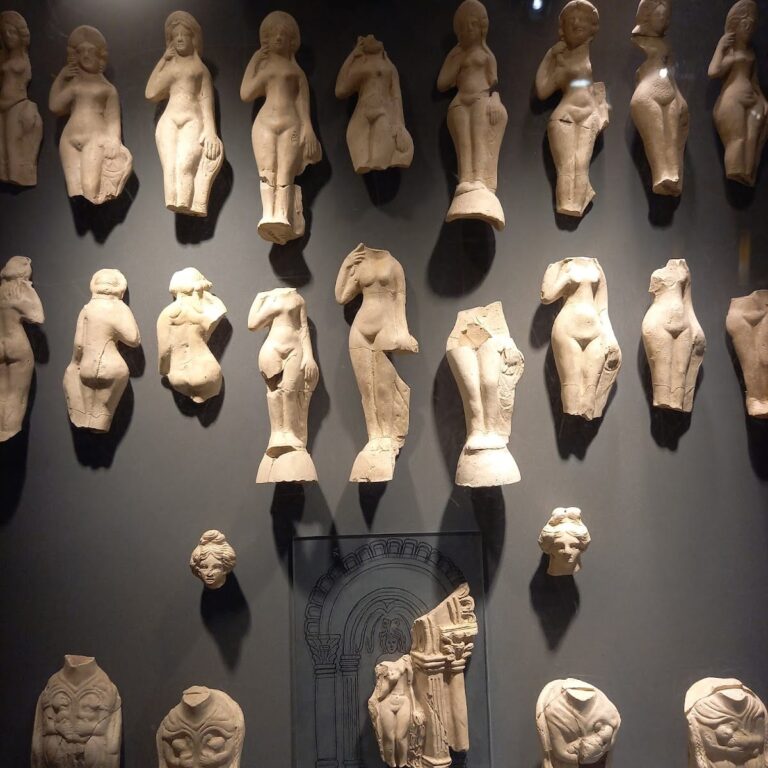
The theatre has also yielded terracotta statuettes of Venus, a monolithic Iron Age stele beside the orchestra, and fragments of a limestone pillar decorated with masks. The pillar probably formed part of the theatre’s decoration and was later reused in the northeastern foundations of the castellum. Earlier excavations took place in 1843, around 1865, and between 1926 and 1928, followed by the complete exposure of the theatre during twentieth-century investigations.
Fortified complex
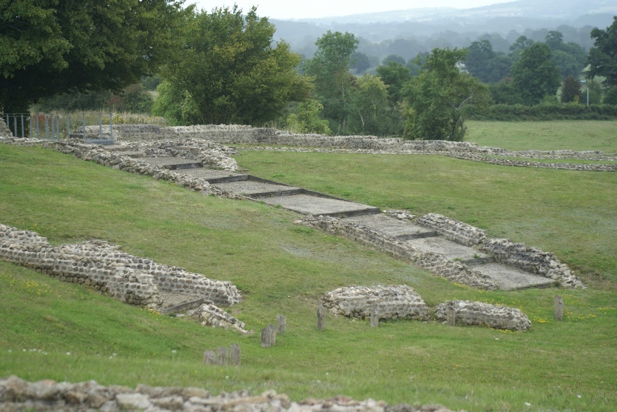
The castellum had a trapezoidal plan measuring approximately 117.50 by 104.25 metres. Its remains reveal three construction phases. At the centre stood a massive rectangular praetorian tower, approximately 22 by 23 metres, built at the end of the second century or the beginning of the third. It had an upper floor, a courtyard, and powerful square turrets at its corners.
The central tower may have been an imperial administrative building linked with the annona, the Roman system for collecting, transporting, and distributing essential supplies, especially grain. Its annexes may have included silos, and four wells were distributed inside and outside the structure. Other interpretations regard the complex as a storage centre for grain, gold, tin, or other valuable goods, and possibly as a collection point for taxes paid in kind.
An earthen rampart and a ditch approximately 10 metres wide enclosed the central tower during the late third century. A gate opened on the southeastern side. After the ditch was filled, a masonry wall approximately 120 metres on each side replaced the earthen defenses, probably early in Diocletian’s reign. The outer wall incorporated nine solid circular towers, each approximately 6 to 7 metres in diameter. One stood at each corner, with five more distributed along the faces. Architectural fragments from earlier buildings, including column shafts and pieces of the masked pillar, were reused in the wall and its foundations.
Two bath complexes occupied the interior of the fortified enclosure. The smaller group in the northeast contained two rooms, including a room heated by a hypocaust, a Roman underfloor-heating system, and a combined changing and boiler room. The larger complex in the southwest measured approximately 12 by 6 metres. It included a vestibule, a cold room, three hypocaust-heated rooms, a warm room, a hot room, and a boiler room. The larger baths probably served senior personnel, while the smaller group may have been used by more modest occupants, including soldiers and enslaved workers.
Public baths
The principal city baths occupied a city block approximately 60 metres wide within a porticoed enclosure that also contained ancillary buildings. The visible remains include a cold bath, a warm room, and hot bathing rooms. The frigidarium, or cold room, contained a rectangular communal pool with a southern apse and an eastern changing room. Its originally larger basin was resurfaced with slate paving after the second half of the second century.
The warm room had a peripheral hypocaust, and another heated room lay to its north. The hot-bath room had two apses, while a furnace stood to the west. An underground aqueduct approximately 8 kilometres long supplied the complex. Two sewers carried wastewater toward the theatre, one from the cold baths and one from the hot baths.
Fragments of mosaics and painted wall plaster came from the baths, with the plaster probably belonging to the thermal complex. Beneath the present church, the remains include a paved pool and hypocaust system. Excavations around 2000 clarified the layout beyond the building, including the area of the church forecourt.
Temple and sanctuary
The sanctuary traditionally known as the Temple of Fortuna occupied an enclosure approximately 70 metres on each side. Fortuna was a Roman goddess associated with fortune and fate, but the actual deity worshipped at Jublains remains unknown. Porticoes surrounded the courtyard, with surviving remains on the southwest side. The sanctuary had two entrances, and the principal approach led through a corridor and staircase. An external structure served for ablutions and received water through an underground channel from the temple.
Statue fragments and white-clay Venus figurines have prompted proposals for an indigenous deity related to Mars or for a mother goddess. The sanctuary’s association with a goddess connected to a spring remains uncertain. The enclosure produced successive Celtic offerings and bronze objects intended as votive gifts. Its builders used local stone for concealed work, Loire shelly limestone for exterior facing, sandstone from approximately 10 kilometres away for the enclosure columns, and tuffeau for the capitals.
The finds include a shelly-limestone head from a mother-goddess statue, fresco fragments, and a painted pigeon that decorated one of the enclosure entrances. Painted plaster also covered the exterior wall. The temple was offset toward the southwest, perhaps because an earlier structure made from impermanent materials was retained or because space was needed for processional gatherings.
The surviving temple remains belong to the podium, specifically the substructure of the cella, the principal enclosed chamber. It formed part of an octastyle peripteral temple, a building with eight columns across its front and a surrounding colonnade, measuring approximately 30 by 20 metres. Coins bearing Nero’s portrait and dating from after AD 65 formed a foundation deposit associated with the replacement of the earlier Gaulish structure by a stone temple. The upper parts were probably altered under the Severan dynasty, which ruled mainly during the late second and early third centuries.
The entrance porches were closed at the end of the third century, and fragments of the mother-goddess statue came from those masonry structures. A coin from Magnentius’s reign, found during excavations in 1959, indicates a later partial reopening. The sanctuary was abandoned around AD 350.
Houses, cemeteries, and earlier occupation
The dwelling at La Boissière, excavated from 1972 to 1979, produced La Tène pottery. It consisted of a main building with ancillary structures, including two wells. Constructed in the first century, it was reorganized around a closed courtyard during the third century and remained occupied until the Middle Ages.
The residential area at La Tonnelle lay between the temple and forum. Excavations conducted from the eighteenth century, around 1834, and between 1864 and 1870 uncovered buildings, Venus statuettes, and a structure that may have been a fanum, a Gallo-Roman temple organized around a central chamber and surrounding gallery. Aerial archaeological research also examined the area, including work in 1989.
The Clos aux Poulains area produced the only mosaic known from the site. It was discovered in 1776 while a field was being cleared and probably came from a bath building. The mosaic was destroyed during the French Revolution, but a drawing and a surviving fragment are preserved in the archaeological museum.
The southern necropolis occupied the area now containing the departmental archaeological museum. Excavations from 1969 to 1972 uncovered mainly cremation burials dating from the first to the fourth century. Another cemetery probably lay near the temple, where a probable mausoleum was associated with a representation of Oceanus now displayed in the museum. Further funerary remains were found elsewhere around the settlement.
Pre-Roman activity is represented by votive swords found at the sanctuary during the nineteenth century, Armorican pottery with impressed-finger decoration discovered in the late 1970s, a possible Iron Age monolith found during the rebuilding of the village church in 1877, and a second stone element discovered in the theatre seating area. Together with the early settlement, sanctuary offerings, craft areas, and later Roman buildings, these remains trace the development of Jublains from a pre-urban Celtic centre to a Roman town and finally to a smaller medieval settlement.