Guérande City Walls: Medieval Defenses of a Breton Town
Site at a Glance
- Popularity
- Medium
- Country
- France
- Primary era
- Medieval
- Eras represented
- Medieval, Early Modern, Modern
- Civilizations
- Duchy of Brittany, French
- Site type
- Military
- Remains
- Wall
On this page30 sections
History
The Guérande city walls are a medieval urban fortification in Guérande, France. Rebuilding began in 1343, and the main campaign took place between 1440 and 1490 under successive dukes of Brittany. The enclosure protected the town’s religious institutions, homes, shops, and public spaces, while serving both defensive needs and local civic identity.
Settlement and rebuilding after 1342
Guérande’s settlement predates its fortifications. The collegiate church of Saint-Aubin is first mentioned in 854, and a borough is recorded in 1206. The town’s form before the fourteenth century is uncertain. Its walls were planned to take in the existing settlement and allow for further growth, although that expansion never fully took place.
In 1342, forces led by Louis de La Cerda sacked Guérande during the Breton War of Succession, a conflict over who would rule the Duchy of Brittany. The town began rebuilding its defenses the following year, using parts of earlier foundations. Work continued for more than a century and a half and formed the enclosure’s last major building campaign.
The main building campaigns
The principal phase of construction ran from 1440 to 1490. Several towers were added to the walls during the 1460s, and the Abreuvoir and Sainte-Catherine towers followed in the 1470s or 1480s. In 1475, a large tower was under construction under the direction of Greffin Hillary, a member of the local lesser nobility, and Jean le Gallus, master builder to Duke Francis II. Local masons, carpenters, and roofers made up most of the workforce. Marks left by stonecutters may also point to the employment of specialists from outside Guérande.
Keeping the defenses in repair required sustained local funding. A wine-retail tax known as the billot was made possible by Guérande’s privileged civic status as a good town. First mentioned in 1415, it helped support municipal administration and was renewed for successive building campaigns. In 1461, the levy was extended to Piriac, Saint-Molf, Mesquer, Saint-Lyphard, Pénestin, and Saint-André-des-Eaux. It could bring in 950 to 1,500 livres tournois a year, while completing the walls was estimated to cost at least 22,500 livres, roughly 18 years of revenue at that rate. On 28 October 1464, Duke Francis II extended the wine levy for six years and added a charge of 20 deniers on each horse carrying fresh or salted fish to help pay for the defenses. The livre tournois and denier were medieval French units of money.
Trade and late medieval defenses
In the Middle Ages, Guérande was the principal town of the peninsula and a center for exchange across a region of varied landscapes. A weekly Saturday market is recorded from 1332. By 1379, local trade included fish and shellfish from the coast and marshes, as well as butter, eggs, and wine. The Saint-Michel Gate opened onto the Nantes road and connected the town with its surrounding territory. Markets near the gate and a covered market at the end of rue Saint-Michel served this activity. Commerce also flourished in the suburbs: the Saint-Michel suburb had numerous weavers and cloth merchants, and the town supplied cloth elsewhere in Brittany. Four fairs were held in the suburbs during the fifteenth century, with the September Saint-Michel fair the largest. They coincided with religious feast days, and some were tax-exempt.
Political tension between the Duchy of Brittany and the Kingdom of France around 1490 to 1500 accompanied a final phase of defensive work. The Franco-Breton War may have helped prompt rapid changes, including adaptations for gunpowder artillery, work at the Saillé and Bizienne gates, and the construction of earthen outworks. An inventory dated 10 July 1495 shows how the defenses were equipped. Cast-iron weapons belonging to the Crown were stored above the Saint-Michel Gate, while weapons owned by the townspeople were kept on its ground floor. The inventory also lists light, portable culverins for use in the towers and handheld arquebuses.
Changes from the sixteenth to the eighteenth century
In 1542, a royal financial officer ordered the construction of gates and drawbridges at the Bizienne Gate. A local feudal obligation, known as the fishmongers’ leap, was also attached to the gate. Guérande’s fish sellers owed the lord of Kermeno, who held the Trévaly fief, a measure of wine or a loaf of bread on the day after Easter. Those who failed to pay were required to jump naked from the bridge into the ditch. The obligation was annulled after 1731. A fief was land or a revenue-bearing right held within the feudal system.
During the eighteenth century, some ditches were filled because of their smell, which was worsened by rubbish dumped by residents. In 1764, the Duke of Aiguillon ordered the Bizienne ditches filled and initiated further landscaping. Parts of the ditches were filled, the earthen outworks were levelled, and the town’s raised promenade was planted with elms.
Revolutionary damage and later alterations
During the French Revolution, royalist forces besieging Guérande fired a cannon at the walls between the Tricot postern and the Saillé Gate. Described as the last cannon shot heard in Guérande, it opened a breach. Residents repaired the damaged stretch with stones taken from regional calvaries, monumental Christian crosses or sculptures of the Crucifixion. The repaired section became known as the Calvaries curtain wall.
Until the early nineteenth century, people were buried in or around Saint-Aubin within the walled town, particularly priests and children. The Sainte-Catherine Tower was demolished in 1818 after falling into poor condition. A nearby opening was made for local lord and mayor Mascarène de la Rivière, who wanted direct access to his manor. The municipality retained the right to close it and did so after his death, as residents increasingly valued the town’s historic fabric. In 1854, the municipality opened a four-metre breach to encourage development beyond the walls. A salt crisis undermined those plans, and the mayor had the breach closed in 1858, leaving a smaller opening known as the Tricot postern.
Restoration took place during the nineteenth century, with further work from the 1970s focused on consolidating the walls and restoring parts of their elevations. Only part of the enclosure has been restored. The walls gained historic-monument protection in 1877, followed by the gates in 1889 and the promenades in 1943. Elm disease killed trees in the 1980s; elms on the protected promenade were replaced with disease-resistant varieties.
Remains
Enclosure and defensive system
Walls and layout
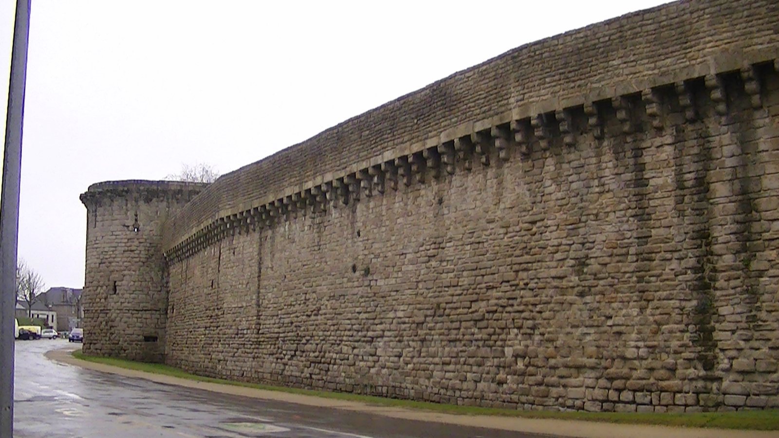
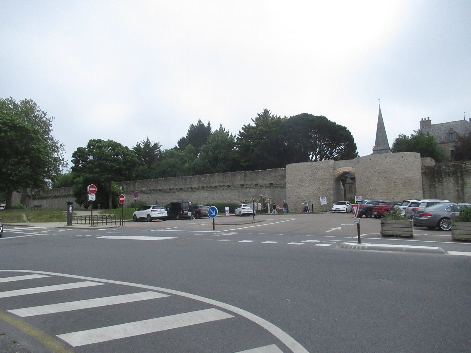
The enclosure extends about 1.3 kilometres and links four fortified gates, six towers, and a small secondary gate opened in the nineteenth century. Two of the gates are flanked by towers, and the Saint-Michel Gate is the most monumental part of the circuit. The walls are about five metres high and three metres thick, standing on granite foundations. They are among France’s best-preserved urban fortifications, and Guérande is one of the few medieval towns to have retained its walls in their entirety.
Stonework, ditches, and outworks
The walls use varied arrangements of stone. Local granite supplied much of the building material, and analysis attributes about 95 percent of the stone in the western wall to material dug from the ditches. Pale local granite from medieval quarries at Trescalan and Clis may also have been used. Dry ditches originally surrounded the enclosure. Surviving stretches lie between the Bizienne Gate and Sainte-Anne Tower, with further sections at the foot of the Abreuvoir Tower and Bizienne Gate.
An earthen outwork was built between the Saint-Michel and Saillé gates in the late fifteenth or early sixteenth century. Its surviving part forms the raised promenade known as the Mail, a name derived from an old mallet-and-ball game. The promenade was later heightened and landscaped with trees. A wall-walk, the walkway along the top of a defensive wall, links sections of the enclosure. Towers were generally set apart from it so that passage along the walls could continue.
Firing defenses
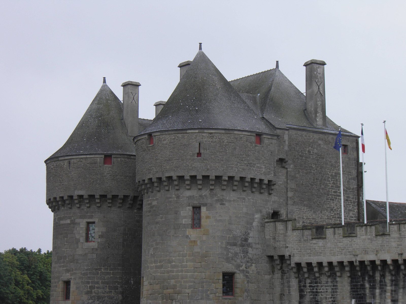
Vertical firing slits pierce the walls and towers, and projecting machicolations allowed defenders to attack from above. Some openings were adapted for cannon, with widened inner spaces and fittings to support the guns. The different forms of openings reflect the defenses’ adaptation to firearms as well as earlier weapons.
Gates
Saint-Michel Gate
At the eastern entrance, the Saint-Michel Gate rises 24 metres and served as the town’s principal gateway. Its fortified passage is flanked by two massive towers and combined with prestigious residential rooms, making it a gatehouse-residence. The gate is recorded around 1350 and was remodeled around 1440 to 1450. The fifteenth-century inner facade has mullioned windows, divided into sections by vertical stone bars, and indicates that the building housed the town’s captains. Its roof was installed in the seventeenth century and restored in the nineteenth. Stonecutters’ marks remain visible. The displayed arms show a silver shield with 15 black ermine spots in rows of five, four, three, two, and one, beneath a ducal crown and surrounded by a cord.
Vannetaise Gate
The northern Vannetaise Gate is regarded as a possible remnant of an earlier enclosure. Its date is disputed, with proposals ranging from the thirteenth century to the mid-fourteenth century. Its towers have arrow slits rather than the cannon openings found in fifteenth-century towers. The gate was walled up for a long period and reopened in 1778.
Saillé Gate
The southern Saillé Gate leads toward the salt marshes and the village of Saillé. Its quadrangular structure includes machicolations, projecting galleries with openings for attacking below, grooves for a drawbridge, and other exterior defenses. The stretch of wall between this gate and the Tricot postern may date to the twelfth century and may be the oldest surviving section of Guérande’s first enclosure.
Bizienne Gate
The western Bizienne Gate is built of granite. A porter’s lodging once stood above it, but its weight weakened the vault and the lodging was removed in 1778. The vault and upper masonry were demolished in 1819 when the structure was thought likely to collapse onto passersby; the outer facade was retained. In 1853, the opening beneath the vault was raised and widened to ease passage, on the condition that the gate keep its medieval character.
Towers
Saint-Jean Tower
Built of granite, carefully cut stone, and rough masonry during the fourteenth and fifteenth centuries, the semicircular Saint-Jean Tower stands southeast of the enclosure, between the Saillé and Saint-Michel gates. It retains its original height. A stone staircase inside was uncovered during excavations in 1990. The medieval Saint-Jean hospital gave the tower its name.
Abreuvoir Tower
Also called the Kercassier, Coëstal, or Coëtpouan Tower, the Abreuvoir Tower dates to 1460 to 1470. It stands on the western wall between the Bizienne Gate and Gaudinais Tower, projecting farther and extending more broadly than the other towers. Straight staircases provided access to its ground floor and upper levels, with the stair from the wall-walk running within the north wall. The lower room has three defensive openings: two directed downward for fire along the wall and a third higher up. A fireplace in the first-floor room suggests that it served as living quarters, while a straight staircase led to the second floor.
Gaudinais Tower
The western Gaudinais Tower dates to the mid-fifteenth century and is also known as the John V Tower. Duke John V of Brittany is credited with having it rebuilt after it was destroyed in a battle whose identity is unknown. Set into the town wall, it resembles the Abreuvoir and Kerbernet towers. Its masonry combines long dressed stones with small blocks.
Kerbernet Tower
Kerbernet Tower, also called Saint-Michel Tower, dates to the mid-fifteenth century. It stands at the northwest corner, between the Vannetaise Gate and Gaudinais Tower. The 1819 cadastral plan calls it Saint-Michel, while Kerbenet was the name of a former fief outside the walls. Long dressed stones and carefully arranged small blocks form its masonry, above a shallow sloping base. Inside, the tower is semicircular. Its lower room, first floor, and attic have similar arrangements; the lower room has three gun-loops, one high and two low, one on each side. Traces of a staircase in the south wall lead from the wall-walk toward a defensive parapet with machicolations. Gargoyles for draining rainwater remain visible.
Sainte-Anne Tower
The mid-fifteenth-century Sainte-Anne Tower strengthened a vulnerable northeastern corner between the Vannetaise Gate and Théologale Tower. It is 12 metres high, semicircular inside, and topped by a conical slate roof. The lower room has three gun-loops, one high and two low, while two more are found on the first floor. The tower also has a second upper floor, and stonecutters’ marks are visible. From 17 November 1850, an apartment for musicians was fitted beneath fire pumps previously installed in the tower. The work included a new opening onto the wall-walk and recreated the conical roof in an earlier form. The tower was renovated in 2022.
Théologale Tower
The late-fifteenth-century Théologale Tower is attached to the eastern wall between the Saint-Michel Gate and Sainte-Anne Tower. Its masonry combines small blocks with long dressed stones. A large round arch at its base opens onto the lower room, which contains four gun-loops. Built-in stone supports in the widened inner openings held weapons. Projecting stone supports mark the position of a former upper floor, and a staircase in the side wall leads to the wall-walk. Stonecutters’ marks remain around the openings.
Postern and traces of lost structures
Tricot postern
The Tricot postern is a small opening near the site of the former Sainte-Catherine Tower. It allowed pedestrian passage from rue du Tricot through the wall, where the street had previously ended. The later breach made in the nineteenth century also left a visible trace.
Sainte-Catherine Tower
The former Sainte-Catherine Tower stood southwest of the walls near the present postern. Mentioned in 1465, it measured 10.5 metres in diameter. A description from 1778 noted its poor condition, and a crack two metres long was recorded in 1810. Traces of the tower remain in the wall and on the ground.
Calvaries curtain wall
The repaired stretch between the Tricot postern and the Saillé Gate is distinguishable by the different color of stones taken from regional calvaries. Its masonry preserves the repair associated with the Revolutionary-era breach.
Urban fabric within the walls
Rue Bizienne and former lordly plots
Within the enclosure, rue Bizienne connects the gate with Notre-Dame-la-Blanche chapel. Fifteenth-century manors and eighteenth-century townhouses stand behind enclosures along the street. The western half of the town was once divided into large plots associated with medieval lordships, with noble houses and extensive gardens set within them.
Market squares and houses
Around Place du Vieux-Marché, granite-fronted houses belonging to landowners and officials concentrate their decoration high on the facades. Their features include carved scrollwork on seventeenth-century dormers, eighteenth-century arches, and nineteenth-century cornices and pediments. A timber-framed house on Place du Pilori represents the homes of merchants and artisans.