Fort Pannerden: A Dutch Blocking Fort on the New Dutch Waterline


Site at a Glance
- Rating
- 4.5
- Popularity
- Medium
- Country
- Netherlands
- Primary era
- Modern
- External website
- Open
- Eras represented
- Modern
- Civilizations
- Dutch
- Site type
- Military
- Remains
- Fort
On this page16 sections
History
Fort Pannerden is a nineteenth-century military fort in the Netherlands, southeast of Doornenburg in the municipality of Lingewaard. Built by the Dutch military between 1869 and 1872, it formed part of the Nieuwe Hollandse Waterlinie, or New Dutch Waterline, a defensive system that used controlled flooding to obstruct advancing armies. The fort guarded the river and canal approaches near the confluence of the Rhine, Waal, and Pannerdensch Canal.
Planning and construction
An earlier proposal for a fort along the main Pannerden dike was drawn up by engineer J.C. Ninaber in 1819, but it was never built. The later Fort Pannerden was constructed between 1869 and 1872, with M. Straalman identified as its builder. Its purpose was to prevent an attacking army from advancing along the Waal toward the defensive line and to protect the Pannerdensch Canal from being dammed. If the canal’s water supply had been cut, the inundation system of the New Dutch Waterline could have been deprived of the water needed to create its defensive barrier.
The fort succeeded Fort Sterreschans, which operated several hundred metres downstream from 1742 to 1795. Its history was also connected with Schenkenschanz, a fortified site that existed several kilometres upstream from 1586 to 1707 at the former Rhine and Waal bifurcation, before the Pannerdensch Canal was created.
Modernization and the First World War
Advances in weapons technology soon made the original fort design obsolete. Between 1885 and 1890, the fort was extensively modernized. Its river battery was rebuilt and strengthened, two additional armoured batteries were installed, and concrete and armour were added to improve protection against artillery. Mortar firing openings extended the fort’s fire coverage.
During the First World War, the Netherlands remained neutral, but Fort Pannerden was manned as part of the Dutch mobilisation. Approximately 300 soldiers were stationed there, although the fort did not see combat. After 1920 it was no longer used because it had become militarily obsolete. For several years, a sergeant who lived nearby with his family managed the site.
The 1940 invasion
In 1939, shortly before the Second World War, Fort Pannerden was designated an infantry support position. Seven surrounding casemates, which were protected chambers or gun positions built into a fortification, were constructed. The four 15-centimetre guns in the reinforced river battery were replaced by two 7.5-centimetre naval guns.
When Germany invaded the Netherlands in May 1940, the fort’s company-sized garrison could offer little resistance. The new casemates had not yet received their intended earth cover, and the guns could not fire inland. German troops crossed the Pannerdensch Canal outside the Dutch guns’ range and isolated the position after breaking through nearby defensive lines. Following light bombardment by infantry and aircraft, German officers demanded the fort’s surrender on the second day of the invasion. The local commander capitulated because he considered further resistance useless.
During the occupation, German forces stripped the fort, removing valuable steel and equipment in particular. After the war, the abandoned building became a source of materials for reconstruction and a dumping place for rubble and munitions.
Cold War use and abandonment
In 1952, the Corps of Air Watch Service established observation post 1J3 on top of the fort. This Dutch Cold War organization used elevated posts to detect low-flying aircraft that radar might miss. The post formed part of a national network of 276 observation posts and operated until 1964, when this part of the network was discontinued.
Fort Pannerden was downgraded in 1959 to a fortification of “no class.” Unsupervised visits by children caused damage and resulted in at least one fatal fall. The fort was subsequently sealed with masonry to prevent further accidents. It became a listed national monument in 1969.
Occupation, restoration, and museum use
State domains acquired the fort in 1965, and ownership passed to Staatsbosbeheer on 1 January 1988. A restoration and museum project initiated by Stichting Fort Pannerden could be carried out only partly, after the municipal administration required the project to begin with no more than 80 percent subsidy. The fort later stood vacant.
On 12 June 2000, about fifteen people occupied the fort to prevent further deterioration. They undertook essential repairs, organized cultural activities, and held monthly tours or open days. Historical research by Stichting Fort Pannerden led to the fort’s inclusion in the Nieuwe Hollandse Waterlinie project in 2005. The New Dutch Waterline is part of UNESCO World Heritage.
In 2006, the municipality offered the occupants management of the fort but not residential use, which they rejected. A police and army operation began on 7 November to evict them after the municipality proposed hotel use for the building. The two-day operation removed approximately 25 people. On 25 November, between 80 and 100 occupants returned, blocked the access road with caravans, and raised the access bridge to hinder another eviction.
The municipality eventually abandoned plans for a second eviction. An agreement approved by the municipality and Staatsbosbeheer on 14 December 2006 made the occupants formal managers, responsible for maintenance and tours, while prohibiting permanent residence. On 11 December 2007, Stichting Fort Pannerden, Staatsbosbeheer, and the municipality announced a new cultural-historical use. The occupants agreed to leave voluntarily when restoration began.
Munitions were cleared from the moat and the surrounding area was investigated in late 2008. The former occupants left in early November, and restoration began on 17 November. The restored fort was given a museum use and reopened to the public in 2016. Staatsbosbeheer remains its owner.
Remains
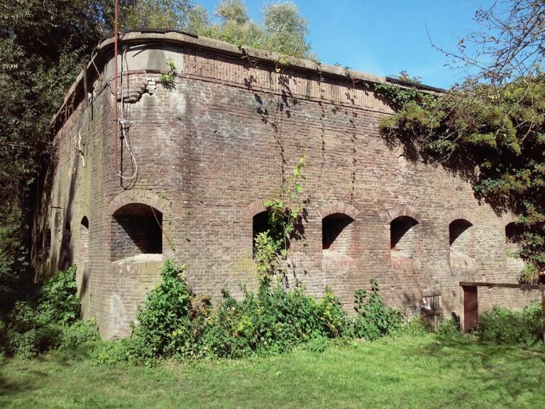
Fort Pannerden is a brick fort measuring approximately 75 by 70 metres, with walls about 2.60 metres thick. It was surrounded by a dry moat. The surviving complex combines the original river-defence arrangement with late-nineteenth-century concrete and armour protection, the 1939 infantry-support additions, and the Cold War observation post on the roof.
River battery and armoured defences
River battery
The main river battery guarded the Rhine and remains an identifiable part of the fort. It was later reconstructed and strengthened with concrete and armour. Before the Second World War, the battery contained four 15-centimetre guns. In 1939 these were replaced by two 7.5-centimetre naval guns, which could not be aimed inland during the German invasion of 1940.
Armoured batteries and moat
Two steel armoured batteries were added on either side of the river battery during the modernization of 1885 to 1890. Their armour was combined with reinforced masonry and concrete, while the roof was also strengthened with concrete. Mortar firing openings formed part of the same effort to improve the fort’s resistance to modern artillery and broaden its defensive fire.
The dry moat remains recognizable around the fort. Munitions were cleared from it during the restoration process, which also included investigation of the surrounding area. The building now contains a museum and exhibition spaces.
Infantry and air-watch structures
Casemates
Seven casemates were built around the fort in 1939 as part of its conversion into an infantry support position. They had been completed by the German invasion, but their intended earth cover had not yet been added. This unfinished protection formed part of the fort’s vulnerability during the fighting in May 1940.
Air-watch post
The 1952 air-watch post survives on top of the fort. It consists of an open observation platform measuring 3 by 3 metres and enclosed by a brick-built parapet approximately 1.5 metres high. From here, observers watched for low-flying aircraft during the Cold War.
Grassland and wall vegetation
Dry river-valley grassland
The fort supports well-developed dry river-valley grassland. Recorded rare plants include red broomrape, greater centaury, stonecrop, rough hawkbit, and large thyme. These plant communities form part of the ecological character of the fort and its surrounding ground.
Walls and rare insects
The wall tops support vegetation associated with candlestick moss and flat meadow-grass. The vertical retaining walls carry well-developed orange shield-lichen vegetation. A population of the very rare southern long-horned bee has also been recorded at Fort Pannerden.
Nearby sites