Fort of São Bruno: A Maritime Bastioned Fortification in Portugal


Site at a Glance
- Rating
- 4.2
- Popularity
- Low
- Country
- Portugal
- Primary era
- Early Modern
- External website
- Open
- Eras represented
- Early Modern
- Civilizations
- Portuguese
- Site type
- Military
- Remains
- Fort
On this page12 sections
History
The Fort of São Bruno is a 17th-century Portuguese maritime fortification at Caxias, Portugal, built during the Portuguese Restoration War to help defend access to Lisbon. Ordered by the War Council of King John IV, it formed part of the first line of coastal and river defenses extending from Cabo da Roca to the Belém Tower.
Construction and early service
The Portuguese Restoration War was the conflict through which Portugal regained and defended its independence from the Spanish Habsburg monarchy after 1640. During this period, Lisbon’s defenses were strengthened against attacks by the Spanish navy. Construction of the fort began in 1647 under the supervision of António Luís de Meneses, governor of the arms of Cascais, later the 1st Marquis of Marialva. The fort was operational by 1649.
São Bruno worked within a mutually supporting chain of forts along the Tagus estuary and reinforced the larger Fort of São Julião da Barra. Its defensive role was also associated with the Lines of Torres, a system of defensive works constructed north of Lisbon during the Peninsular War to impede invading forces.
Changes during the eighteenth century
Rodrigo da Silveira became governor in 1701. By 1735, silting had deactivated the fort and made its artillery unusable. João Tomás Correia, a military engineer and cartographer, depicted it in the 1736 Book of Various Plans of This Kingdom. Restoration had been completed by 1751.
The fort appears to have suffered relatively little damage in the 1755 Lisbon earthquake. Its military condition nevertheless changed repeatedly during the eighteenth century. It was deactivated several times, and in 1777 it was reported to be unguarded and occupied by civilians. During the Spanish-Portuguese War of 1762 to 1763, it returned to service with 16 cannon.
Nineteenth-century military decline
Manoel António da Cunha was appointed governor in 1800, and the fort was garrisoned and armed with 11 pieces in 1802. Advances in military technology soon made its defensive function obsolete. In 1815, sand had again invaded the fort, the right tenaille, a low V-shaped defensive work placed in front of a fortification, had collapsed, and doors and windows were missing.
King Miguel I used São Bruno for target practice in 1831, firing at barges moored in the Tagus. These were the only occasions when artillery was fired from the fort. After the Portuguese Civil War, during which Miguel was monarch from 1828 to 1834, the fort was deactivated and ceased to serve military purposes.
Later uses and conservation
During the late nineteenth century, the fort was leased to a private individual for nine years. In 1895, the General Administration of Customs requested it for use as a customs post. Adaptation works in the early twentieth century prepared it for new institutional functions. The fort was returned to the government in 1902 and occupied by the Guarda Fiscal from 1903 until 1946. This Portuguese customs and excise service used it to combat smuggling. The Mocidade Portuguesa, a state youth organization created under the Estado Novo dictatorship, also used the fort as a sailing centre in 1941.
In 1946, the Mocidade Portuguesa took over the fort. The first conservation and restoration intervention by the Directorate-General for National Buildings and Monuments took place between 1952 and 1958. After the Carnation Revolution, the fort was transferred in 1976 to the Fund for Supporting Youth Organizations for use as a holiday camp, and in 1977 it passed to the Portuguese Association of Youth Hostels.
São Bruno was designated a Property of Public Interest by Decree 95 of 12 September 1978. Recovery works followed in 1982 and from 1984 to 1986. From 22 October 1984, the Corps of Volunteer Nautical Lifesavers was responsible for the installations and maintained them in good condition. Further recovery and rehabilitation were carried out by the Directorate-General for National Buildings and Monuments and Oeiras Municipality in 1997, followed by improvements to the surrounding area and access in 2000. The fort is currently in good condition and serves as the honorary headquarters of the Portuguese Association of Friends of Castles. Its name refers to its proximity to the Laveiras convent of the Carthusian friars of Saint Bruno, a Catholic contemplative monastic order.
Remains
Plan and defensive works
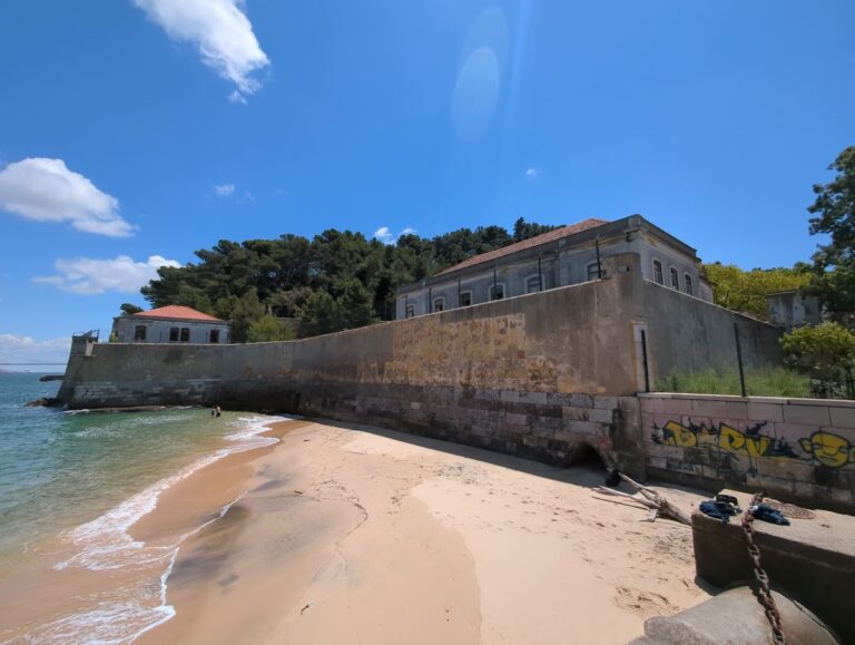
The fort stands on a rocky outcrop at the meeting point of the Barcarena stream and the Tagus estuary in Caxias, within Oeiras Municipality. It is a small maritime fortification with a bastioned plan, meaning that projecting angular defenses protect the walls and cover the ground around the entrance and adjoining sections. Its polygonal star-shaped outline surrounds a raised rectangular central core. The design is Baroque and gives priority to military function over ornament.
Arms Gate
On the landward side, the Arms Gate forms the principal entrance. Its large round-arched opening is carried on pilasters. Above the gateway are a stone inscription plaque dated 1647 and the Portuguese coat of arms, linking the surviving entrance to the fort’s construction during the Restoration War.
Bastions and sentry boxes
Two bastions protect the landward side and the entrance. Their corners contain square sentry boxes, each topped by a pyramidal cupola. These projecting defenses form part of the fort’s compact system for controlling the approaches from land.
Central core and river batteries
Vaulted central section
The central section has a rectangular plan and contains vaulted rooms. Above these internal spaces, a paved terrace carries a raised battery. The arrangement combines protected accommodation and working areas with positions intended for the fort’s artillery.
Low-angle batteries
Two batteries were designed for low-angle fire toward the river, matching the fort’s position beside the Tagus estuary and its role in the maritime defense system. At least one lower battery had been invaded by sand by 1735. Sand again obstructed the fort in 1815, when the right tenaille had collapsed and doors and windows were missing. Later restoration, recovery, and rehabilitation works brought the surviving structure to its present well-preserved condition.
Nearby sites