Fort Liefkenshoek: A Sixteenth-Century Scheldt Fortification in Belgium


Site at a Glance
- Rating
- 4.4
- Popularity
- Medium
- Country
- Belgium
- Primary era
- Early Modern
- External website
- Open
- Eras represented
- Early Modern, Modern
- Civilizations
- Dutch, French
- Site type
- Military
- Remains
- Fort
On this page9 sections
History
Fort Liefkenshoek is a sixteenth-century military fortification in Beveren, Belgium, on the left bank of the Scheldt opposite Fort Lillo. A fortification was built here in 1579, probably on the initiative of Antwerp’s magistrate, and a separate fortified chamber was added in 1582 at the insistence of William of Orange, the leading political figure in the Dutch Revolt against Spanish rule. The two works formed part of the rebel Dutch defensive system around Antwerp and were completed by the engineer David van Orliens. Liefkenshoek was entirely renewed in 1614 according to a specification prepared by van Orliens.
The Dutch Revolt
In June and July 1584, troops serving Alexander Farnese, Duke of Parma, tried to seize Liefkenshoek and Lillo. Farnese was the Spanish commander directing the reconquest of rebel-held territories in the southern Netherlands. Richebourg, identified as Robert de Melun, Marquis of Roubaix, captured Liefkenshoek on 10 July 1584. Farnese then used the fort as the starting point for an approximately 800-metre pontoon bridge across the Scheldt. The bridge was intended to stop forces from the northern insurgent territories from relieving Antwerp, which was under siege.
Justin of Nassau, a Dutch military commander, retook Liefkenshoek in early April 1585. The recovery came too late to prevent Antwerp’s fall on 15 August. After the city capitulated, Liefkenshoek and Lillo remained in the hands of the insurgents of the northern Netherlands. From 1585 to 1786, the two forts served as forward positions of the Dutch Republic, the state also known as the Republic of the Seven United Netherlands.
A fortress and customs position
The Peace of Münster in 1648, part of the agreements that ended the Eighty Years’ War, formally recognized Liefkenshoek as a fortress of the Dutch Republic. Dutch control therefore extended along the Scheldt almost to Antwerp. Together with Fort Lillo, Liefkenshoek controlled shipping moving to and from the city.
The fort also contained a toll and customs station. It collected the old Zeeland toll as well as changing import, export, and transit duties. Seagoing vessels were prohibited from sailing directly to or from Antwerp. Their cargo was transferred to smaller vessels on the Zeeland section of the Scheldt, both to assert Zeeland’s sovereignty and to protect the Zeeland islands. This closure and tariff system redirected some overseas trade towards Dunkirk and Ostend, although Antwerp’s decline and Amsterdam’s rise had other causes as well.
From Austrian rule to Belgian service
French troops captured Liefkenshoek in 1747 during the War of the Austrian Succession, a conflict over the succession to the Habsburg territories. The Treaty of Aix-la-Chapelle returned the fort to the Dutch Republic. Under the Treaty of Fontainebleau of 1785, the Dutch Republic ceded it to the Austrian Netherlands in February 1786.
During the French occupation from 1794 to 1814, the fort was enlarged with a powder magazine and a bombproof casemated barracks. After the Belgian Revolution of 1830, which created an independent Belgian state, Dutch troops retained Liefkenshoek and Lillo until 1839. Liefkenshoek was taken out of military service by the Belgian government in 1894.
Between 1843 and 1952, the fort served as a lazaret, a quarantine station or hospital for isolating people suspected of carrying contagious diseases, within the Scheldt quarantine service. After the Second World War, it became a base and depot for the Belgian navy. From 1964 to 1973, it was used as a holiday centre for Belgian professional soldiers and their families. The fort was later closed, and the municipality of Beveren purchased it in June 1980.
Restoration and changing surroundings
The surrounding polder landscape was expropriated and raised for the development of the Waasland port. As a result, the fort became isolated within the port area. Restoration of the casemates in the Kat began in 2006. Four of its casemates opened as a visitor and interpretation centre in September 2007, and wider restoration was completed in 2023. The work included a new pedestrian bridge and the restoration of the surrounding earthworks towards their original form.
Fort Liefkenshoek was designated a protected historical monument in 1985. The fort and a broad surrounding area form part of the Natura 2000 protected area called “Mudflats and Polders of the Lower Scheldt,” which has special protection for birds. The fort also has habitat protection because it may provide hibernation sites for bats.
Remains
Fortification and earthworks
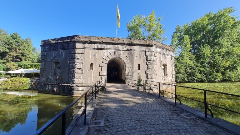
Fort Liefkenshoek is a redoubt, a small enclosed fortification forming an independent defensive position, built on the Scheldt dike at Sint-Anna Polder. Its position faces Fort Lillo on the opposite bank. The surviving layout retains the basic plan of a sixteenth-century fortification. Enclosing earthworks and ramparts form a circuit around the fort, preserving the relationship between the defended interior and the surrounding Scheldt landscape.
A pedestrian bridge now crosses the defensive works and gives access to the fort. A path follows the ramparts around the enclosure, and an observation tower stands within the site. The fort’s physical setting links its earthworks with the Scheldt, the adjacent polders, and the wider port area, although modern port development has left the historic stronghold isolated within the Waasland port.
The Kat and French additions
The central semicircular structure known as the Kat belongs to a later phase of the fort rather than to its original sixteenth-century plan. The French built it in 1810 and 1811 as a bombproof barracks. Its 12 casemates, fortified chambers protected by thick walls or earthworks, could accommodate approximately 400 soldiers. A powder magazine was added during the same French period.
Four casemates in the Kat contain the visitor and interpretation centre. Its displays cover the Eighty Years’ War and navigation, including a reconstruction of an old vessel. Other presentations address flooding, dike construction, fishing, and agriculture, with a model of the Doel cog, as well as the fort’s history and quarantine function. Industrial development and new port infrastructure on the left bank are also presented.
The Doel cog
The Doel cog, a type of medieval vessel, was discovered in 2000 slightly north of Liefkenshoek. A model is displayed in the interpretation centre, linking an archaeological find from the surrounding Scheldt landscape with the fort’s presentation of navigation and the history of the left bank.