Fort Kléber: A German Artillery Fort in Wolfisheim, France


Site at a Glance
- Rating
- 4.5
- Popularity
- Medium
- Country
- France
- Primary era
- Modern
- External website
- Open
- Eras represented
- Modern
- Civilizations
- German
- Site type
- Military
- Remains
- Fort
On this page11 sections
History
Fort Kléber is a German-built artillery fort in Wolfisheim, France, constructed between 1872 and 1875 as part of the fortified belt around Strasbourg. It belongs to the Biehler type, a system developed by German major general Hans Alexis von Biehler in which artillery forts were spaced so they could support one another without forming a continuous wall. The fort helped create a discontinuous defensive enclosure around Strasbourg.
Construction and defensive role
Initially designated Fort VI, the work was later named Fort Fürst Bismark for Otto von Bismarck, the German statesman who served as Imperial Chancellor from 1871 to 1890. Its position allowed it to cover the road descending from the Saverne Pass and to coordinate artillery fire with Fort Frère farther north. The fort was modernized during the 1880s as military technology and defensive requirements changed.
Fort Kléber formed one element of a larger system established after Strasbourg fell in 1870. The plan called for thirty-six forts, but fourteen were constructed: eleven in Alsace on the left bank of the Rhine and three in Baden on the right bank. Together, these works formed the fortified belt intended to protect the city and its approaches.
Renaming and later use
The fort received the name Fort Kléber in 1918, commemorating Jean-Baptiste Kléber, a French general of the Revolutionary period. Between June 1940 and November 1944, it was again called Feste Fürst Bismark. After that period, the name Fort Kléber was restored.
The French Army occupied the fort until 1996. The municipality acquired it in 2008 and converted the former military site into the Fort Kléber urban park, which opened to the public in 2010. This change gave the fort a new civic use while retaining its defensive structures and layout.
Remains
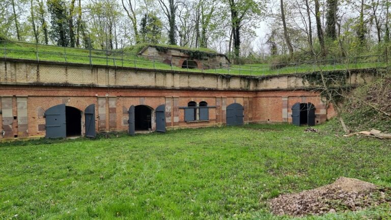
Fort Kléber is a polygonal work shaped as a flattened, irregular hexagon measuring approximately 200 metres in length and 70 metres in width. Vosges sandstone and brick form the masonry structure, which is covered with earth. A dry ditch surrounds the fort, measuring about six metres deep and approximately ten metres wide.
Entrance and ditch defenses
Gorge entrance
The drawbridge entrance and the barracks open onto the gorge ditch, the rear side of the fort. In front of this ditch, a place of arms, an area where troops could assemble, forms a bastion, or projecting section of the defensive work.
Protected ditch structures
Five caponiers, protected structures projecting into the ditch, originally defended the surrounding excavation. During the modernization of the late 1880s, they were replaced by counterscarp casemates, which were protected defensive chambers on the outer side of the ditch.
Artillery and protected buildings
Firing platforms
The original artillery was positioned in the open air on sixteen firing platforms. Personnel could shelter in traverses, raised protective structures placed between the gun positions.
Barracks protection
The late-1880s modernization added a one-metre layer of sand and a 1.2-metre concrete shell above the barracks. These protective layers altered the earlier masonry work and formed part of the fort’s adaptation to changing artillery power.
Present park arrangement
The former military site is now arranged as an urban park. Its facilities include a children’s play area, a fitness trail laid out in the ditch, and a small farm-animal zoo in the courtyard of the north barracks.