Fort de Tournoux: A French Mountain Fortification Complex


Site at a Glance
- Rating
- 4.3
- Popularity
- Very Low
- Country
- France
- Primary era
- Modern
- Eras represented
- Modern
- Civilizations
- French
- Site type
- Military
- Remains
- Fort
On this page22 sections
History
Fort de Tournoux is a mid-nineteenth-century French military fortification complex in France, built by the French Army during the 1840s to 1860s to defend the Ubaye Valley and the approaches from Italy and Savoy. Its position above the meeting area of the Ubaye and Ubayette valleys made it the strategic core of the French defensive system in the valley, particularly in relation to the route through the Col de Larche.
Foundation and construction
The need for a major defensive position grew after a broad road through the Ubaye and Ubayette valleys was begun in 1830. The improved route increased the possibility of an Italian invasion through the Alpine passes. Major General François Nicolas Benoît Haxo, a nineteenth-century French general and military engineer known for designing fortifications, selected the site. Haxo was regarded as a successor to Sébastien de Vauban, the leading French military engineer under Louis XIV.
The French Army engineering service directed the principal construction, assisted by local blacksmiths, carpenters, and stonemasons. The original establishment was planned for about 900 soldiers and officers. Its garrison included personnel from the 83rd Infantry Regiment and the 162nd Artillery Regiment, as well as the 111th Territorial Infantry Regiment and the 157th Infantry Regiment.
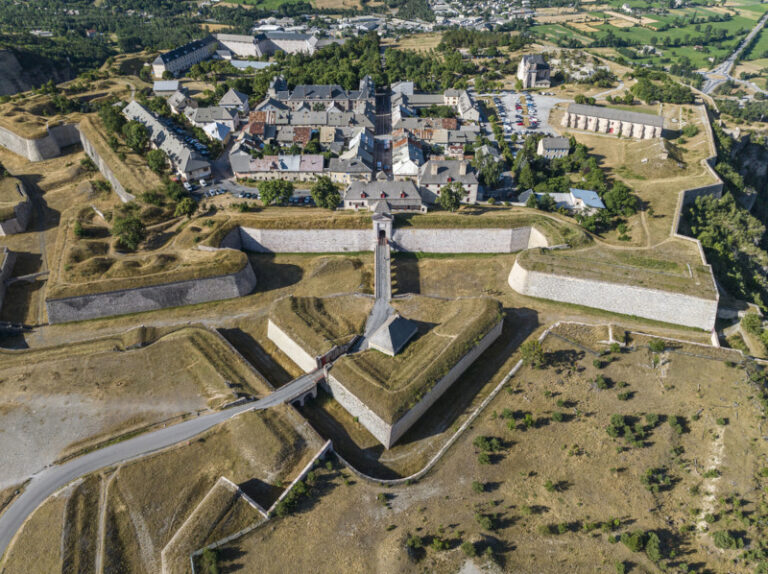
The fort took its name from the hamlet of Tournoux, which occupies a plateau overlooking the Ubaye and an access route toward Italy. The complex stands about two kilometres south of the hamlet and extends above the strategic junction of the two valleys. Its buildings rise in successive levels along the mountainside, a form that later prompted descriptions such as the “Military Versailles of the 19th century,” the “Eiffel Tower of the Ubaye,” a miniature Great Wall, and a Tibetan monastery or lamasery.
Expansion under changing artillery systems
After 1874, Fort de Tournoux became part of the Séré de Rivières system, a nationwide network of French forts, batteries, and defensive positions developed after the Franco-Prussian War under General Raymond Adolphe Séré de Rivières. The upper defenses were enlarged around 1880, and further high batteries and outposts were developed as improvements in artillery increased effective firing ranges.
Until 1890 the fort was occupied only during the summer. It then began to receive a permanent garrison. Electricity was installed in 1908, allowing the cableway to operate and making it easier to move equipment and ammunition between the lower and middle levels.
From the First World War to the Maginot Line
France and Italy were allies during the First World War, so the fort did not see combat during that conflict. Instead, it served as a prison for captured German officers.
During the 1920s and 1930s, Fort de Tournoux and the surrounding defensive network were incorporated into the Alpine sector of the Maginot Line. This was a twentieth-century system of fortified defenses built by France along vulnerable national borders, including the Alpine frontier facing Italy. A project prepared in 1934 for four 155 mm guns, however, left the guns uninstalled. Nearby positions at Roche-la-Croix, Viraysse, Mallemort, Cuguret, and Saint-Ours formed part of the wider network and were linked operationally by communications.
French forces began rearming the complex before the Second World War, but it remained lightly equipped in 1940. During the Italian offensive in June of that year, artillery positions at Fort de Tournoux fired on the advancing forces and halted the Italian advance in the Ubayette Valley. French troops later surrendered under the terms of the French armistice.
Occupation, post-war use, and conservation
German troops occupied the fort in 1944 as Free French forces advanced up the Ubaye Valley after landing in southern France. Before withdrawing toward nearby Maginot positions, the Germans damaged the water and electrical installations and removed or destroyed fittings. French forces then retook the complex. Fighting resumed in spring 1945 before the French capture of the Ubaye Valley in April.
The French Army continued to occupy Fort de Tournoux after the war. The complex became an ammunition store in 1948. The upper fort was vacated in 1987, while the lower section was evacuated by 2009. The B12 ammunition store remained in use until 1989.
After demilitarization, responsibility passed from the state and military authorities to the Communauté de communes Vallée de l’Ubaye Serre-Ponçon. The Fortifications de l’Ubaye association undertook maintenance and organized guided visits, while the local authority carried out renovation and conservation work. The community later received a heritage-preservation award, and the restoration initiative was selected by the Mission Bern.
Remains
Fort de Tournoux is an extensive mountain complex distributed from approximately 1,300 metres above sea level to about 2,000 metres, across roughly 700 metres of vertical relief. Its principal levels are the lower administrative and barracks area, Batterie XII, Fort Moyen, Fort Supérieur, and the high artillery positions. Faced stone, locally quarried mountain stone, lime mortar, Ubaye marble, and later concrete were used across the complex. Large sections were excavated into the mountain to protect them from bombardment.
Principal fort levels
Lower barracks and administrative area
The lower area, known as Caserne Pellegrin or Espace Pellegrin, stood at about 1,300 metres beside the main road through the passes. Its large wooden barracks was demolished in 2008 because of the danger of collapse. A nearby hospital closed in 2014. The former Caserne Caron was converted in 1964 into a naval oxygenation and holiday center and was later abandoned in 2014.
Batterie XII
Batterie XII, also called B12 or Batterie 12, occupies the lower third of the mountainside. It was built between 1846 and 1862 and contained artillery positions at barracks level. In 1940, two 81 mm mortars fired eastward and two 95 mm guns fired northeast along the valley. Four 155 mm guns were positioned in the village of Tournoux, approximately 2.4 kilometres away.
Fort Moyen
Fort Moyen, also called Fort Grouchy, occupies the middle level at approximately 1,600 metres. Its buildings are joined by stairways, bridges, and ramps. Two elongated buildings, each three storeys high, provided accommodation. The building on the right housed officers, while the one on the left accommodated soldiers and non-commissioned officers. Fort Moyen was constructed principally between 1846 and 1862.
Fort Supérieur
Fort Supérieur occupies the upper part of the main slope at approximately 1,750 metres. Several buildings were constructed there principally between 1852 and 1860. By 1940, the level included an anti-aircraft battery. Water reached Fort Supérieur through pipes from a spring near the summit and was stored in large tanks.
High batteries and outposts
Batterie du Clos des Caurres
The Batterie du Clos des Caurres, also called Batterie des Caurres, lies above Fort Supérieur at approximately 1,780 metres. Built between 1879 and 1881 as part of the Séré de Rivières system, it was planned for six de Bange 155 mm guns. A de Bange gun was a nineteenth-century French rifled artillery piece, using steel construction and explosive shells for greater accuracy and range than earlier bronze smoothbore cannons.
An underground gallery linked the battery to Fort Supérieur between 1880 and 1883. A deep ditch was completed in 1890, followed by a connecting wall built between 1890 and 1897. The position was designed for 656 men and seven officers. Concrete coverings were begun over vulnerable areas before the First World War but remained incomplete in 1914. A gun chamber for two 75 mm guns covered the flank of the Vallon Claus battery. Later armament included eight 95 mm guns and four 120 mm guns, while other recorded arrangements list four 75 mm guns, four 155 mm guns, and three 81 mm mortars.
Fort de Serre de l’Aut
Fort de Serre de l’Aut was a small outpost built between 1890 and 1893 on a cliff edge west of the main complex, approximately 1.1 kilometres away. A military road connected it to the principal fortification. Four 95 mm guns armed the outpost, while an observatory and the Batterie de Serre de l’Aut occupied the summit area.
Batterie du Vallon Claus
Batterie du Vallon Claus lies approximately 5.2 kilometres north of the main complex. Built between 1880 and 1885, it is a walled mountaintop enclosure with observation posts extending westward. Between two and six 75 mm guns were assigned to the battery. Its garrison of 75 men lived in a nearby barracks connected to the main fort by an underground ammunition magazine. The battery covered the entrances to the Maurin and Plate Lombard valleys.
Lignes des Abrupts
Four observation posts known as the Lignes des Abrupts extend from Batterie du Vallon Claus. They are simple, nearly square buildings set at elevations between approximately 2,130 and 2,273 metres. The posts had no permanent armament.
Roads, passages, and defensive connections
Mountain roads and stairways
Exterior roads, bridges, ramps, and long stairways connect the principal levels. A serpentine road with hairpin bends linked the lower areas to Fort Moyen and Fort Supérieur. It was designed for mule-drawn carts and had a maximum gradient of approximately 10 percent.
A subterranean staircase with about 1,000 steps was excavated through the mountain so that movement could continue when the cableway was unusable or under attack. The work was never completed. Openings in the cliff provided ventilation and lighting and allowed excavated spoil to be removed.
Cableways and covered road
Two cableway lines connected the lower administrative area with Fort Moyen. After electricity was installed in 1908, the system transported stores and ammunition. A covered road also linked Fort Moyen with the village of Tournoux, providing another entrance and exit. Loopholes and gun emplacements heavily protected this route.
Walls and drawbridges
Fort Supérieur and Batterie du Clos des Caurres were protected by inner and outer faces of defensive ditches, known as scarp and counterscarp walls, together with sliding drawbridges. When closed, the bridges withdrew into guardhouses on rollers.
Construction and internal organization
Behind the principal barrack buildings were protected open walkways. The buildings had staircases but no internal corridors, so rooms were reached from rear walkways and landings. These passageways also encouraged natural ventilation and reduced damp. Workshops and magazines stood above the barrack buildings.
The ammunition magazines were built as structures within larger buildings to improve airflow and limit damp. Their floors were fixed with bronze nails to minimize sparks. Arched structures attached to the rock face above the central barracks and entrance road formed protective barriers against rocks loosened by freezing and thawing. Fallen rock was collected and reused as construction material.
Early artillery included bronze cannons firing round shot toward the roads descending from the Col de Vars and Col de Larche and toward the upper Ubaye Valley. Later modernization led to a proposal for three 145 mm guns in a Fort Grouchy gun chamber, but the project was abandoned. The four-gun 155 mm project for Batterie XII was structurally completed in 1934, without the guns being installed.
Communications and later physical changes
Communication between the mountain positions initially relied on semaphore, an optical signaling system using visible signals. A telegraph line was later installed and eventually linked Fort de Tournoux with other forts in the valley and the surrounding Alpine network.
Since military occupation ended, conservation work has included new roofs on the principal Fort Moyen blocks and stabilization of tunnels in Fort Supérieur. Batterie des Caurres has been reused as a relay for television and mobile-phone signals. The observatory has also been used for communications, although its possible military use remains uncertain.