El Castellar: A Multiperiod Archaeological Complex beside the Ebro


Site at a Glance
- Rating
- 4.4
- Popularity
- Very Low
- Country
- Spain
- Primary era
- Medieval
- Eras represented
- Iron Age, Classical, Medieval
- Civilizations
- Celtic, Roman, Taifa Kingdoms, Taifa of Zaragoza
- Site type
- City
On this page18 sections
History
El Castellar is an extensive archaeological complex in Spain, beside the Ebro River near Torres de Berrellén in Zaragoza, whose earliest probable occupation dates to the seventh century BC, during the regional Iron Age. The site preserves evidence from several cultures and periods and forms part of a wider chain of settlements along the Ebro escarpments, extending from the Pola farmstead in the west to Juslibol in the east.
Iron Age and Vascon frontier
The earliest occupation probably began when Celtic tribes from central Europe reached the region in the seventh century BC, introducing the Iron Age, a period when iron tools and weapons became widespread. Related remains survive at Valdemoro, also called Pola, and at the settlement of Miranda.
The Montes de El Castellar formed the southern limit of the Vascones, an ancient population settled mainly in the western Pyrenean and upper Ebro regions. A long-established transhumance route, used for the seasonal movement of livestock between grazing areas, passed beside the settlement on its way to the Pyrenees. This route may help explain the possible presence of a Vascon defensive and territorial stronghold, although the identification of those remains remains uncertain.
Roman settlement
Around 77 BC, during the First Civil War of the Roman Republic, the area may have contained the winter quarters of Castra Aelia, established by Quintus Sertorius. Sertorius was a Roman general who led a major rebellion against the Roman Senate. The historian Titus Livy may have been describing an earlier urban settlement beside which these winter quarters were established.
Ruins from the later Roman imperial period confirm the existence of an urban settlement at El Castellar. Its activities may have included the extraction and trade of salt from mines in the surrounding area, although that connection remains uncertain. The Roman settlement may have been abandoned between the fourth and fifth centuries. Continued occupation during the Visigothic period has not been established.
Muslim district and medieval fortification
A diploma issued in 1091 in the name of Sancho Ramírez refers to an Islamic district in the area of Super Caesaraugusta. It describes a defensive castle overlooking the Ebro and its floodplain at Torres de Berrellén. The district appears again in a diploma of 1115. Sancho Ramírez, king of Aragon and Pamplona in the eleventh century, also ordered a fortification project at El Castellar in 1086.
The 1091 diploma excluded a quarter called al-Mahall from a grant of land and fields. This quarter is identified with the areas now known as Casas Bajas and Casas Altas, near the Mina Real and the boundary of Alfocea. A judgment issued by James I at Huesca in 1268 referred to the same quarter as Almahaja while defining the boundaries of the quarter, El Castellar, and Alfocea.
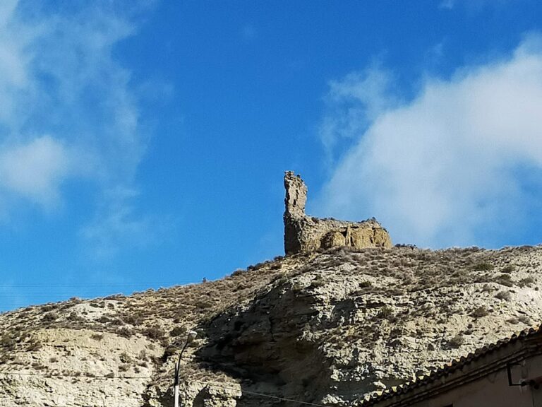
The oldest parts of the fortified settlement preserve remains of the Muslim castle. Its position allowed observation across the Ebro floodplain, while a system of watchtowers in the surrounding hills communicated through visible signals. In 1086, Sancho Ramírez may have ordered either a complete castle or a simpler defensive tower nearby. If the second interpretation is correct, Alfonso I, known as Alfonso the Battler, may have built the castle and established its population later. Under that interpretation, the earlier tower either did not lead to a settlement or was neutralized by Muslim forces, and Alfonso I then ordered the area to be repopulated. The tower would have protected settlers rather than serving as a base for the conquest of Saraqusta.
Burial grounds and later condition
Muslim-period funerary remains include rock-cut tombs and a late Muslim cemetery on the opposite bank of the Ebro, shortly before the Jalón River enters it. Numerous human remains from this cemetery were found in the mid-twentieth century. El Castellar’s former Jewish population used a separate burial ground called Campo del Judío.
El Castellar was declared an archaeological zone by a resolution of 17 April 2006, published on 22 May that year. Part of the complex lies within the San Gregorio military training area, affecting the usual approach from the Torres de Berrellén crossing, while most of the remains lie outside the training area. Abandonment and looting have contributed to the site’s progressive loss. Erosion is intensified by collapses and falling blocks along the Ebro escarpments, as well as by river flooding and torrential rain.
Remains
Settlement and fortifications
El Castellar occupies the Montes de El Castellar beside the Ebro and extends across a large, difficult-to-access archaeological landscape. The principal remains include a fortified settlement and the oldest surviving portions of the Muslim castle, positioned to command a broad field of view over the Ebro floodplain.
Muslim castle and fortified settlement
The castle forms part of the oldest surviving defensive fabric at the site. Its elevated position overlooked the floodplain and connected with a wider system of lookout structures in the surrounding hills. The settlement associated with it includes the areas called Casas Bajas and Casas Altas, identified with the quarter excluded from the 1091 grant and located near the Mina Real and the territorial boundary of Alfocea.
Possible Vascon stronghold
Other remains among the ruins may represent a Vascon fortification or small defensive stronghold. Their interpretation is uncertain, but their possible connection with the ancient settlement and the nearby transhumance route forms part of the site’s Iron Age and pre-Roman archaeological context.
Roman urban remains
Roman ruins indicate an urban nucleus from the imperial period. The settlement may have been connected with salt extraction and trade in the surrounding area, though this proposed function is not certain.
Watchtower network
Pola and El Molino
The defensive system associated with El Castellar included the watchtower of Pola, which has disappeared, and the watchtower of El Molino, whose remains survive north of the castle. These structures formed part of the lookout network used to observe the surrounding territory and communicate warnings by visible signals.
Sobradiel and La Lora
The watchtower of Sobradiel is better preserved than some of the other towers, although its façade was recently damaged by collapse. The Tower of La Lora, once located in the Ebro floodplain, has disappeared. The wider system also included an advanced post at Sobradiel.
Almenara and Torres de Berrellén
Additional elements of the defensive network included Almenara near Alagón and the towers of Torres de Berrellén. Together with the hilltop and floodplain structures, they formed a chain of positions associated with the fortified settlement.
Funerary remains
Muslim tombs and Campo del Moro
Rock-cut tombs survive among the Muslim-period funerary remains. The late Muslim cemetery known as Campo del Moro lay on the left bank of the Ebro, opposite the main site and near the Jalón’s confluence with the river. Human remains recovered there in the mid-twentieth century provide physical evidence of burial activity connected with the Muslim-period landscape.
Campo del Judío
Campo del Judío was a separate Jewish burial place associated with El Castellar’s former Jewish population. It forms part of the complex’s evidence for the different communities connected with the settlement.
Escarpments and preservation
The site’s physical remains occupy escarpments shaped by rotational landslides, in which earth or rock moves along a curved surface, causing the upper slope to rotate as it descends. The low slope, weak resistance of the local geology, and the Ebro’s strong erosive action contribute to falling blocks and collapses. Floods and torrential rain further affect the survival of the archaeological remains.
Nearby sites