Dally Castle: A Thirteenth-Century Fortified Hall House in Northumberland


Site at a Glance
- Rating
- 4.3
- Popularity
- Very Low
- Country
- United Kingdom
- Primary era
- Medieval
- Eras represented
- Medieval
- Civilizations
- English
- Site type
- Military
- Remains
- Castle
On this page12 sections
History
Dally Castle is a ruined thirteenth-century stone motte-and-bailey fortress in the United Kingdom, standing on the Chirdon Burn in Northumberland. Probably built around 1237, it is described as one of the first hall houses in Northumberland, combining a principal residential hall with defensive features. The site lies on a tributary of the North Tyne, about 6.4 kilometres west of Bellingham and 8 kilometres west of Bellingham Castle.
Foundation and medieval enlargement
The castle was first recorded in 1237, although its exact construction date and builder are uncertain. It has been linked to a fortified building described as a “house in the form of a tower” being constructed in Tynedale that year. The work may have been undertaken by David de Lindsay, a Scottish nobleman who held the senior judicial and administrative office of justiciar of Lothian, or by his younger namesake, who was a ward of Alexander of Scotland. No positive evidence establishes the identification.
The original building was probably a two-storey fortified hall house. During the later thirteenth century it was completed or enlarged with a north-west turret, a southern wing, and defenses at roof level. A north-east turret, further strengthening at the south-west corner, and an enclosure extending down the southern slope were added in subsequent phases. The castle’s stronghold may correspond to a building described by Hugh of Bolbec, a sheriff, although that proposed connection also remains uncertain.
Occupation, decline, and reuse
Dally Castle remained inhabited until the sixteenth century or later. By the time William Camden visited the area during the reign of James I, it had become ruinous, and Armstrong’s map also represented it as a ruin. The roofless walls apparently collapsed during the eighteenth century. In the early nineteenth century, accessible stone was taken for other local construction, especially Dally Mill. When John Hodgson later visited, no masonry could be seen above the turf.
William Charlton of the Bower purchased Dally Castle from the Earl of Suffolk in 1664, while the remainder of the estate passed to Sir Edward Haggerston in 1841. In 1888, W. L. Charleton cleared enough debris to expose parts of the castle, but the excavation was poorly recorded. Fine columns, probably supports for the hall roof, were removed for use in a piggery, and Charleton also took an unusually rare Early English pierced chimney head. Finds beneath the north-west turret, including a helmet, a sword point, and “fairy” tobacco pipes, indicate occupation into the sixteenth century or later. The site’s history and the identity of its builder nevertheless remain partly unresolved.
Remains
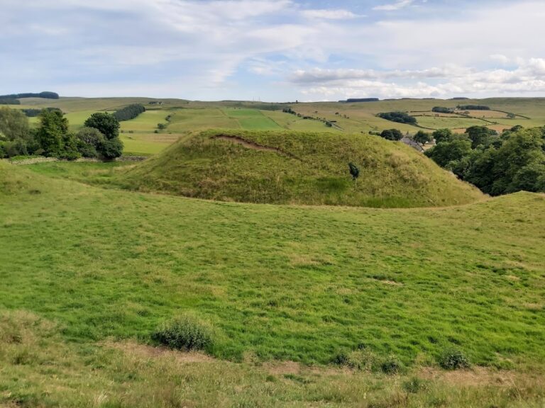
Dally Castle occupies the narrow summit of a high, steep-sided natural ridge, or kaim, separating the upper and lower Chirdon valley. The ridge is pierced by the stream at its eastern end. A larger gap and a smaller notch on the east were cut through the ridge to isolate the castle area. The western end of the castle overlooks the larger ditch, while masonry traces survive on a low mound east of the eastern ditch. The surviving evidence represents a defended complex of buildings, earthworks, and crossings rather than a single isolated structure.
Earthworks and approaches
The castle was protected by a large ditch and by a curving ditch that ran around the hill and castle through the two gaps in the ridge. A separate enclosure extended from the south-east corner down the southern scarp, or steep slope, to this ditch. The site was also associated with a ford and with a narrow timber pack-horse or footbridge across the Chirdon Burn. The bridge probably belonged to a period when either Dally Castle or Dally Mill was occupied.
Bridge abutments
The bridge’s surviving abutments are made from rubble set in mortar. Their ends facing across the stream form unusual semicircular projections. These stone supports preserve the position and construction of a crossing connected with the castle’s wider landscape.
Main fortified building
The principal building was an internally oblong block measuring approximately 17.2 by 8.1 metres. Its walls were about 1.75 to 1.83 metres thick and contained narrow, fish-tailed loopholes, openings through which weapons could be fired, about 5.1 centimetres wide. The openings were later blocked with masonry faced in ashlar, a finely cut and dressed stone. In the east gable, the internal splayed opening, or embrasure, was partly retained and converted into a cupboard.
South front and entrance corner
A heavily barred window replaced a loophole in the westernmost bay of the south front. It had quarter-round moulding with a radius of about 5.7 centimetres, and the edges of the loopholes were carefully rounded. At the south-west corner, a narrow doorway with chamfered jambs and sill led to what was probably a staircase within the wall or a small turret. This vulnerable corner was strengthened and reconstructed twice.
Turrets and buttresses
Turrets were attached to the two northern corners. The north-west turret measured about 2.92 by 4.22 metres internally and had walls approximately 1.37 metres thick. Its external base course joined irregularly against the double-chamfered base of the main building. The north-east turret appears to have replaced an earlier staircase or small chamber within the wall, whose lower part remains visible inside it. Its interior walls are thinner, rougher, and deep red in colour, and they were never plastered.
The north front had two broad buttresses, both later additions. One retains two weathered courses, while the other remains incomplete. Their arrangement indicates that they were built with the north-west turret but before the north-east turret. A larger southern turret or wing was attached to the main block, but the south wing has almost entirely disappeared. Only short lengths of wall bonded to the original south wall survive.
Interior supports and fireplaces
The ground floor contained central pillars supporting a longitudinal beam, on which the first-floor joists rested. The ends of the joists were notched to runners about 9.5 centimetres wide, supported on corbels. On the first floor, a central colonnade with responds, or half-piers at the ends of an arcade, probably carried arches or, more likely, a timber roof framework. At the west end, a fireplace was flanked by detached columns with moulded caps and bases.
A second fireplace beside the south-west doorway was probably inserted later, since it blocked an earlier archery embrasure. Its projecting hood rested on two plain, splayed corbels. Thin, flat-bedded rubble in the fireplace and turret is comparable to material at Haughton Castle, and the west end of Dally Castle has a plan resembling Haughton Castle’s east end.
Roof defenses and surface finishes
The north and south sides had double external base courses that did not continue across the gables. Several stone channels about 32 centimetres wide may have been connected with parapet construction, although they do not by themselves prove that parapets existed. Roof-level defensive walks would have been expected if the building was the stronghold described by Hugh of Bolbec, and they would have become particularly necessary after the loopholes were blocked.
Most of the interior, including the ashlar central space and the rubble masonry of the turret, was covered with a thin, carefully finished layer of plaster. The plaster ended in a straight edge about 3.8 centimetres wide. The north-east turret formed an exception, retaining its rough, unplastered interior.
Associated buildings and later structures
The castle proper consisted of two portions. The eastern portion was a building about 9.1 by 4.6 metres, set on a different orientation from the main block. Its date and purpose are uncertain, and it may have been a barn or chapel. Foundations immediately east of the ruins have also been interpreted as belonging to a chapel, while traces farther east represent a smaller square-plan building.
Dally Castle House, a farmhouse, was built beside the castle in the eighteenth century. Across the road, Dally Mill was used to grind wheat during the Napoleonic War. Stone from the castle was reused in the mill’s construction, linking the surviving industrial building with the later dismantling of the medieval fortress.
Nearby sites