Celtic Circular Wall of Otzenhausen: A Treveran Oppidum in Germany

Site at a Glance
- Rating
- 4.7
- Popularity
- Low
- Country
- Germany
- Primary era
- Iron Age
- External website
- Open
- Eras represented
- Iron Age, Classical
- Civilizations
- Celtic, Roman
- Site type
- Military
- Remains
- Fortified Town
On this page14 sections
History
The Celtic circular wall of Otzenhausen is a fortified Celtic settlement near Nonnweiler in Germany, built during the later Iron Age La Tene period. Associated with the Treveri, a Celtic people of the region, it is regarded as one of their five known town-like settlements. Its development began around the transition from the fifth to the fourth century BC and continued through several phases until the first century BC, when the defenses formed a complete ringwall.
Early fortification and Treveran settlement
The first fortification was probably built as a refuge fort. Two cross-walls blocked the mountain spur during the early phase, creating a defensible position on the Dollberg. After a break in occupation from the late fourth century until about the middle of the second century BC, settlement resumed. During the second and first centuries BC, the defenses were enlarged substantially. A later strategic change shortened the southern section, producing three identifiable construction phases before the enclosure reached its final form in the first century BC.
The site may have served purposes beyond refuge. Excavations and other investigations indicate settlement, trade, ironworking, and activity in a religious area. Its exact function remains uncertain, but it probably acted as a central place for the surrounding region. It may have been a seat of power or a permanent settlement rather than only a temporary stronghold. Evidence from the wider settlement also points to the production of millstones and the keeping or breeding of meat animals and riding horses. The region was associated with steel production by approximately the second century BC.
Roman conquest and later religious use
The Treveri became involved in the Gallic War, the conflict between Rome and many Gallic peoples during the first century BC. Roman forces probably captured the ringwall around 51 BC under Titus Labienus, a commander serving Julius Caesar. The enclosure appears to have been evacuated without a siege or battle. A Roman military camp built at nearby Hermeskeil between approximately 53 and 51 BC is connected with this campaign. After the war, the ringwall was abandoned around the middle of the first century BC. Smaller settlements continued nearby, but the enclosure was not permanently resettled by the Celts.
A Gallo-Roman religious complex was later established in the former Celtic cult area. It included several small temples and a sacred precinct, while a settlement beside the old access route contained a major temple in the Treveran region. A small sanctuary dating from the second or third century AD may have been dedicated to Diana, the Roman goddess associated with hunting, or Mars, the god associated with war. These later religious uses maintained the site’s reputation as a central place of worship.
The identity of the ringwall’s last ruler is uncertain. Indutiomarus, a prominent Treveran leader known from Julius Caesar’s account of the Gallic War, has been proposed. Two Celtic princely burial mounds found at nearby Schwarzenbach in 1849 may have contained the remains of the fortification’s founders.
Memory, protection, and archaeological investigation
During the Thirty Years’ War, fought from 1618 to 1648, people from the surrounding area used the remains as a refuge. The first known representation of the ramparts appeared in the Grimburg Salbuch of 1589, and another depiction was published in the Gazette de Metz in 1836. The popular name Hunnenring has no demonstrated connection with the Huns. It may come from an old term associated with a king, a word linked to giants because of the enclosure’s size, or the romantic historical vocabulary of the early nineteenth century.
In 1836 or 1837, a petition by Count Villers von Burgesch and a visit by a Prussian royal helped secure protection for the monument. Stone removal from the ramparts for building purposes then ceased. An area cleared inside the enclosure for the royal visit is still known as the King’s Square.
The Provincial Museum of Trier excavated at the site in 1883, and the Rheinisches Landesmuseum Trier conducted further work between 1936 and 1940. Later investigations included a project by the municipality of Nonnweiler and the European Academy of Otzenhausen in 1999 and 2000, work by Terrex from 2001 to 2012, and several campaigns by the University of Mainz from 2006 onward. About three percent of the interior has been investigated. The Keltenpark at the foot of the hill includes a reconstruction of a Celtic village based on excavated evidence from the ringwall and other Celtic settlements.
Remains
Enclosure and defensive works
Ringwall and forewall
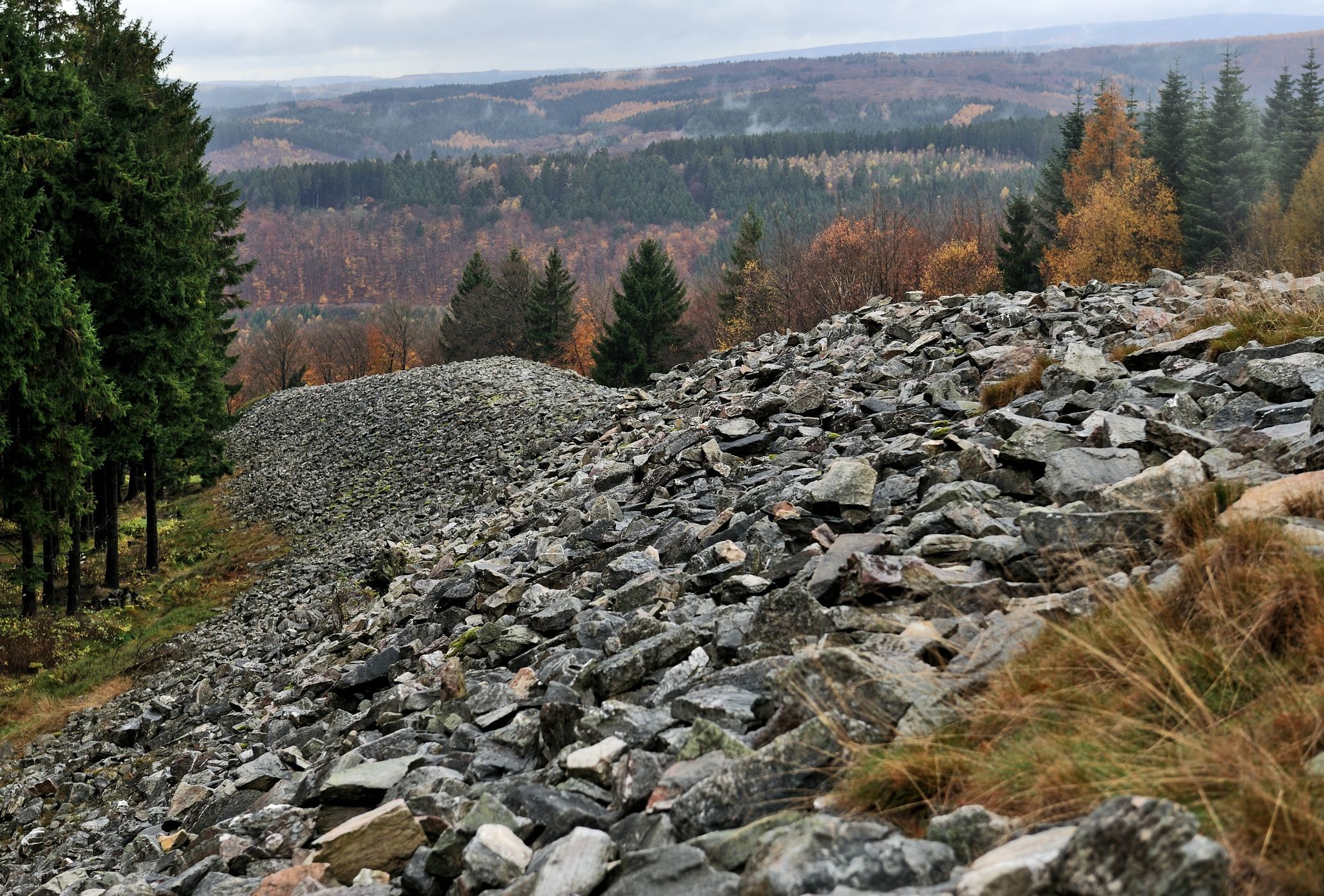
The remains occupy the summit of the Dollberg at approximately 695 metres above sea level. Following the hill’s topography, the enclosure has a roughly triangular or wedge-shaped plan with rounded ends and lies within the wider landscape of the Prims valley. Its ramparts extend for approximately 2,500 metres and enclose about 18 hectares. The enclosure measures about 460 metres from west to east and 647 metres from north to south. The stone-filled earthworks contain an estimated 240,000 cubic metres of material.
The main fortified area covered about 13 hectares. In front of it stood a forewall enclosing approximately 5 hectares, particularly along the southern side, where the outer rampart lay about 40 metres from the main wall. Its ends approached the main rampart without joining it. Smaller walls protected the steep southern terrain, while the flatter northern side required a much larger fortification. The visible remains consist chiefly of two circular earth ramparts covered with stones. The surviving rampart reaches up to about 10 metres in height and exceeds 40 metres in basal width in places.
Timber-laced construction
The original walls used murus Gallicus, a Celtic timber-laced construction in which horizontal beams were interlocked with earth, loose stone, and rubble. The timber framework helped the wall withstand fire and battering, while the stone facing protected it from attack. A wooden breastwork or palisade stood along the crest. On the northern side, the original wall may have reached approximately 25 metres in height and had a base about 25 metres wide. Thousands of beams were incorporated into the ramparts. The survival of the stone-covered earthworks reflects the later disappearance of the original earth and timber.
Entrance and interior
Western gateway
The principal entrance was on the western side. It consisted of a wooden, double-winged gateway approximately 6 metres wide, supported by eight posts. A central post divided the entrance into two passages of about 2.5 metres each. The posts stood in sockets and were wedged with stones, while broken rock helped prevent erosion of the ground. A possible eastern gate has not been confirmed.
Spring and internal buildings
The western gateway led into the enclosure, where a spring supplied water. The spring emerges because impermeable quartzite underlies the hill. Postholes and sockets for wooden uprights show that buildings once stood inside the enclosure, although their functions remain uncertain. They may have provided accommodation or storage.
Religious remains
Roman temple
A Roman temple measuring approximately 2.15 by 2.70 metres was built during the second or third century AD. Its construction used quartzite rubble and brick-shaped sandstone. It formed part of the later religious use of the former Celtic cult area, alongside several small temples and a sacred precinct.
Archaeological finds and present condition
The 1883 excavations recovered pottery fragments near the spring. Work in the 1930s and 1940s exposed the gateway and brought to light pottery, brooches, coins, spindle whorls, glass beads, and part of a bracelet. These finds provide evidence for activity within the enclosure and help define its settlement and use. Modern woodland covers most of the area, while the stone ramparts remain exposed.