Castra of Würzberg: A Roman Auxiliary Fort on the Odenwald Limes
Site at a Glance
- Popularity
- Low
- Country
- Germany
- Primary era
- Classical
- Eras represented
- Classical
- Civilizations
- Roman
- Site type
- Military
- Remains
- Fort
On this page10 sections
History
The Castra of Würzberg was a Roman fort near Bullau in Germany, on the older Odenwald sector of the Neckar-Odenwald Limes, Rome’s frontier system in the provinces of Upper Germania and Raetia. It housed a numerus, an auxiliary army unit of about 160 men, distinct from a standard cohort; the particular unit stationed here is unknown.
Construction and frontier service
The fort was first built during the reign of Emperor Trajan (AD 98–117), with construction conventionally dated to around AD 100, within an uncertainty of about five years. A statistical reassessment of coin finds from forts across the wider Upper Germanic-Raetian Limes instead favors AD 107–110 for construction of the Odenwald frontier line. This later estimate does not derive from new excavation at Würzberg.
The first enclosure was made of timber and earth. During the reign of Hadrian (AD 117–138), it was replaced by two dry-stone faces with earth packed between them. Between AD 140 and 150, builders replaced that arrangement with a stone wall bonded with mortar. The fort had been abandoned by AD 159 at the latest, when Rome shifted its frontier forward and relinquished the Odenwald line.
Later references and archaeological investigation
The site may correspond to Wllineburch, named in an 819 description of Michelstadt’s territory, or to the ruined Vullonoburg mentioned in a 1012 charter about the Lorsch hunting preserve. Older literature called the fort Hainhäusel or Hainhaus. The latter name can be confused with a separate fort near Michelstadt-Vielbrunn.
A reliable description of the fort appeared in 1736. Early in the nineteenth century, antiquarian Johann Friedrich Knapp investigated it for Count Franz I of Erbach-Erbach. The German Reichs-Limeskommission, established to study the Roman frontier, carried out the first scientific excavations in 1895 under the local direction of Friedrich Kofler. Investigations in the 1930s identified a settlement associated with the fort. In 1963, the Saalburg Museum examined the site under archaeologist Dietwulf Baatz. Considered with work at nearby Hesselbach, these studies supported comparable reconstructions of other Odenwald forts for numerus units. The fort and adjacent frontier installations are protected archaeological monuments under Hessian law.
Remains
The fort’s irregular quadrilateral enclosure and its defensive ditch define the site’s basic layout, while a bath stood outside the fort. The remains lie about 2.5 km south of Würzberg, in a clearing at the northern edge of the forest between Würzberg and Bullau. The site occupies a north–south ridge at about 525 m above sea level. The ground slopes by roughly 1 m from west to east and from north to south. A low rise called Hainhäusel, about 200 m southeast of the fort, reaches approximately 531 m.
Fort enclosure and interior
Plan and position
The enclosure covered about 6,000 m². Its uneven four-sided plan measured 72.03 m across the front, 74.10 m at the rear, 81.03 m along the north side, and 80.63 m along the south. Its outline remains visible in the undeveloped ground.
Walls, entrances, and ditch
The enclosure foundations were 1.25 m thick, while the masonry above ground measured 90–95 cm across. Four entrances pierced the boundary. The principal gate faced the Limes; a smaller rear entrance, probably used during the first building phase, was later blocked. The corners were rounded. Kofler and Baatz differed over whether the main and side gates had towers: Baatz considered towers likely at those entrances, and further excavation was judged necessary to resolve the question.
A strip of level ground 50–80 cm wide separated the wall from an outer ditch about 6 m across and 1 m deep below that strip. The ditch’s outward-facing slope was steeper than its inner slope, and earth banks interrupted it directly before the gates. Along the inside of the defensive wall, which carried a wall-walk, excavators found a gravel-surfaced road dating to the second building phase. They also located the main cross-road between the side gates and the road leading inward from the front gate.
Interior structures
Excavations by Kofler and Baatz revealed fragmentary evidence for buildings within the fort. These structures are thought to have had timber frames and may have included paved floors.
Frontier landscape
From the fort, the Limes continued south along a wooded ridge toward Hesselbach, descending gradually from about 525 m to 489 m. Ditches and bank-like rises near some watchtowers along this route belong to medieval landworks rather than to the Roman frontier.
Bath
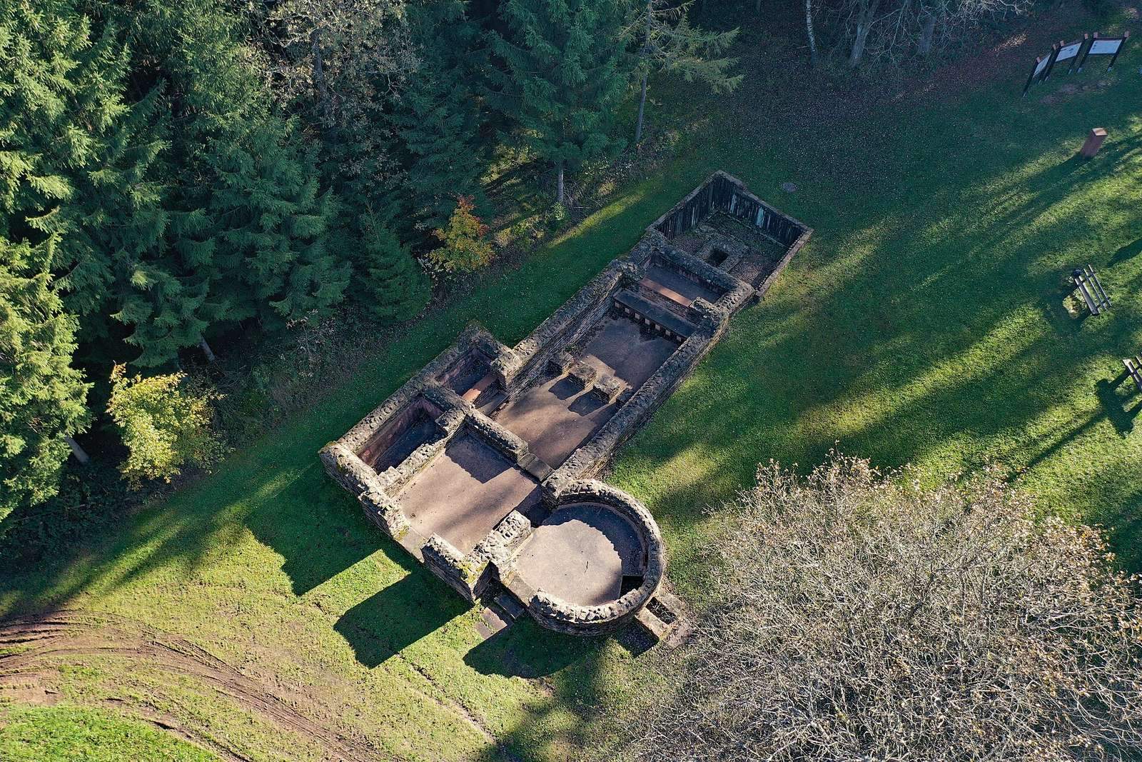
The small bath stood about 60 m south of the fort’s right-hand side gate and contained the functions of a typical Roman bathing establishment. From north to south, its rooms included a wooden changing room within a stone building, a cold room with a cold-water pool, a warm room with a corresponding pool, and a hot room with a hot-water pool. A circular dry-sweat room lay west of the cold room. Two heating rooms were positioned west of the sweat room and south of the hot room. The bath had plastered, painted surfaces, glass windows, and taps supplying hot and cold running water. Some of its bricks were associated with the Twenty-Fourth Cohort of Roman Citizen Volunteers, stationed at Heidelberg-Neuenheim. Its foundations and parts of the standing masonry have been conserved; the Hessian State Office for Monument Preservation examined and conserved the bath in 1980.