Castle Rising Castle: A Norman Fortress and Hunting Residence in Norfolk


Site at a Glance
- Rating
- 4.6
- Popularity
- Medium
- Country
- United Kingdom
- Primary era
- Medieval
- External website
- Open
- Eras represented
- Medieval, Early Modern
- Civilizations
- English, Norman
- Site type
- Military
- Remains
- Castle
On this page20 sections
History
Castle Rising Castle is a ruined medieval fortification in the United Kingdom, built soon after 1138 by the Anglo-Norman aristocrat William d’Aubigny II. Its Norman and Romanesque architecture reflects both defensive ambitions and the status of its founder, who became Earl of Arundel after marrying Adeliza of Louvain, the widow of Henry I. William used the wealth gained through this marriage to establish Castle Rising and New Buckenham Castle and to carry out works at Arundel Castle.
Before and after the Norman Conquest
After the Norman Conquest, the land was granted to Odo, Bishop of Bayeux and Earl of Kent. He may have used it as an administrative centre, and buildings of Saxo-Norman date already occupied the site before the castle was constructed. Archaeological investigations have confirmed earlier Saxon occupation, placing Castle Rising within a longer-established settlement landscape.
The location lay about 5 miles (8 km) from the port of King’s Lynn. In the twelfth century, boats could probably reach it through a channel linked with the marshy Babingley River. Its military value was limited and may have extended chiefly to use as a regional assembly point. The relatively inexpensive, accessible land and its suitability for a large hunting park were probably more important considerations for William d’Aubigny.
William d’Aubigny’s foundation
Castle Rising was planned as both a fortress and a palatial hunting residence. A deer park and rabbit warrens formed part of the lordship, while the settlement was moved northward and reorganised as a planned town beside the new castle. A nearby dovecot and religious house were also associated with the estate. The arrangement placed the town before the fortification and the deer park behind it, giving the castle a carefully structured relationship with its surroundings.
A Norman chapel, probably built around 1100, was enclosed within the castle defences. Its religious role was later replaced by a parish church dedicated to St Lawrence in the relocated town. In 1145 William received permission from King Stephen to operate a mint at Castle Rising. A Jewish community was probably established in the town in connection with this development, but the mint closed after Henry II restricted regional minting, and the community resettled in King’s Lynn.
William and his descendants appear to have regarded New Buckenham Castle as the principal castle of their Norfolk estates rather than Castle Rising. It remains uncertain how often William himself lived at Castle Rising. A second construction phase probably took place during the 1170s, perhaps in response to the Anarchy, the English civil war of 1138 to 1154 between supporters of Stephen and Empress Matilda. William supported Henry II, Matilda’s son and Stephen’s successor, and fought the rebels at the Battle of Fornham in Suffolk. Around this period, the earthwork defences were raised to approximately twice their earlier height, and the west bailey interior was elevated into a platform.
Succession and the de Montalt inheritance
The castle passed through William d’Albini III, William IV, and William V. When William V died without children in 1224, the inheritance went to his brother Hugh, who also died childless. Castle Rising then passed to the de Montalt family in 1243. By the thirteenth century, the chapel inside the defences had probably ceased to function as a religious building and had been adapted for secular use.
In 1327 Robert de Montalt sold his reversionary rights in the castle to the Crown for 10,000 marks, while retaining a life interest for himself and his wife Emma. After Robert’s death, Emma transferred her rights to Queen Isabella for £400 in 1331.
Isabella of France and the royal residence
Isabella of France, queen consort of Edward II and mother of Edward III, made Castle Rising one of her principal residences from 1331 until her death in 1358. She maintained a courtly household that included minstrels, huntsmen, and grooms. Edward III and members of the royal household visited her at least four times.
During Isabella’s residence, substantial residential, religious, and service buildings were constructed or altered. Edward III intended the castle to pass to his son, Edward the Black Prince, after Isabella’s death. In 1337 he made it a permanent possession of the Duchy of Cornwall, the hereditary estate traditionally assigned to the heir apparent, together with the surrounding manor and a share of the tolls from King’s Lynn.
The Black Prince ordered repairs during the 1360s, including expenditure on a structure called the “Nightegale Tower” in 1365. Its exact location is uncertain. The castle appears to have remained in good condition during this period and may have been equipped with two cannons. Local forces were ordered to assemble there several times during the 1380s because of the threat of French invasion.
Later medieval decline
Under Richard II, the Crown transferred or granted Castle Rising several times. These arrangements included a grant to John, Duke of Brittany, in exchange for the Château de Brest, followed by grants to Thomas, Duke of Gloucester, and Edmund, Duke of York. The courts later declared these grants illegal, and Castle Rising was returned to the Duchy of Cornwall in 1403.
During the fifteenth and early sixteenth centuries, the castle remained associated with the Duchy of Cornwall. Henry VI mobilised its defences in 1461 during the Wars of the Roses, the dynastic conflicts between the houses of Lancaster and York. The site increasingly functioned as a hunting centre rather than a military stronghold, and its constable was often also the surveyor or ranger of Rising Chase. The castle received visits from Mary Tudor, Queen of France, and Charles Brandon, Duke of Suffolk. Its constables included Lord Ralph de Cromwell and John de Vere, Earl of Oxford.
Intermittent repairs could not prevent deterioration. Reports from 1482 stated that the buildings were no longer weatherproof. A survey made between 1503 and 1506 described the castle as badly repaired and noted that the keep roof was rotten. Another survey in 1542 and 1543 recorded extensive ruin, a collapsed keep roof, and probably collapsed floors in the great hall and chamber.
After the southern range and kitchen were demolished, new guest lodgings, stables, and service buildings were erected, although these replacements were not robust. The forebuilding was later converted into a separate group of chambers. A passage was cut through the keep walls to connect these rooms with the kitchens while avoiding the ruined spaces.
Post-medieval changes and conservation
Henry VIII granted Castle Rising to Thomas Howard, Duke of Norfolk, in 1544. By the 1570s, rabbit warrens had heavily damaged the castle and its earthworks. By the end of the sixteenth century, most buildings in the inner bailey had been demolished, leaving the ruined keep, latrines, and a newer chapel. During the seventeenth century, the keep’s gravel ground floor was dug up, the forebuilding apartments were abandoned, and the surrounding chase was disparked in 1644. Stone was removed in 1705 for repairs to a nearby sluice gate.
The Howard family retained ownership. In the nineteenth century, Mary Howard and Fulke Greville Howard began restoration work that included excavating the keep basement, repairing masonry, and removing about 1 metre (3 feet 3 inches) of accumulated ground from the inner bailey. This work destroyed much medieval archaeological evidence but exposed the earlier chapel. Henry Harrod excavated the chapel in 1851, after which Mary Howard continued the work and restored its masonry following Fulke’s death. A nineteenth-century dispute over whether the chapel was Anglo-Saxon or Norman was eventually resolved in favour of a Norman date.
Castle Rising was open to the public by 1900. Part of the keep was reroofed and converted into an apartment for a caretaker. In 1958, the Ministry of Works assumed legal custody because of the castle’s deteriorating condition, and conservation during the 1960s stabilised the keep. Archaeological investigations examined the keep in 1970, the church and earthworks in 1971 and 1972, and the inner bailey between 1973 and 1976. Further excavation took place in 1987 during construction of a ticket office.
English Heritage took control of the site in 1983. Since 1998, management has been returned to the owner, Baron Howard of Rising, while English Heritage continues to retain custody. Castle Rising is protected under United Kingdom law as an ancient monument and is a Grade I listed building. Its surviving fabric remains predominantly ruinous, while the site continues in use as a publicly accessible heritage site.
Remains
Castle Rising occupies about 5 hectares (12 acres). Its layout consists of an oval inner bailey between rectangular western and eastern baileys, with substantial earthwork banks and ditches defining each area. The principal buildings are concentrated in and around the inner bailey, where the great keep, forebuilding, chapel, church, and excavated residential and service ranges preserve the changing character of the castle from the twelfth to the sixteenth centuries. Local brown carrstone rubble, oolite ashlar, limestone, Sandringham sandstone, flint, timber reinforcement, and later brick all appear in the surviving fabric.
Baileys, banks, and entrance
Western bailey
The western bailey was levelled to form an earthen platform and is no longer directly connected with the rest of the castle. It measures about 125 by 50 metres and is surrounded by a ditch up to 2 metres deep. The platform rises about 5 metres and is enclosed by a wall up to 1.5 metres high. Its elevated form belongs to the enlargement of the earthwork defences associated with the later twelfth-century phase.
Eastern bailey and bridge
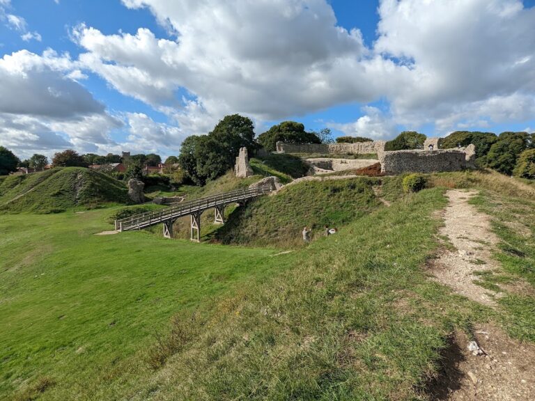
The eastern bailey measures approximately 82 by 59 metres, while the larger eastern earthwork extends to about 155 by 92 metres. It formed a protective buffer before the entrance to the inner bailey. The earthwork reaches up to 9 metres in height and has an outer ditch about 4 to 5 metres deep. A stone bridge approximately 24 metres across links it to the inner bailey. The bridge retains some original masonry at its base, while the remainder has been rebuilt several times.
Gatehouse and inner defences
The bridge leads to a rectangular stone gatehouse dating from around 1138. It was originally taller and longer, contained a portcullis, and was later protected by a stone barbican. The outer west wall was about 6 feet thick and the east wall about 5 feet thick, while the arched entrance measured about 12 feet wide. A spiral stair on the south exterior once led to a watch room in the lost upper storey.
The inner bailey is an oval ringwork, an enclosure formed chiefly by a bank and ditch, measuring about 73 by 60 metres and having a circumference of approximately 320 metres. Its banks now rise about 18 metres above the bottom of the dry defensive ditch, roughly twice their original height. A palisade or timber revetment probably stood along the bank top. Parts of a fourteenth-century brick wall survive on an additional 1-metre layer of lime-stabilised sand. Blind arcading on the inner face and beam holes may have supported a wall-walk. Three medieval towers stood along the defences, although only two can be identified from the earthworks.
Great keep and forebuilding
Oblong hall-keep
The great keep is an early example of an oblong hall-keep, a broad, relatively low principal fortified building organised around a great hall. It measures about 24 by 21 metres and stands approximately 15 metres high. Its design was probably influenced by Norwich Castle and also resembles the keep at Falaise. The building is made mainly of local brown carrstone rubble with oolite ashlar facings, with limestone, Sandringham sandstone, and flint also present. Timbers embedded within the masonry helped reinforce the structure.
Prominent pilaster buttresses divide the north and south elevations, while clasping corner buttresses form four projecting turrets, each about 7 feet wide. Romanesque decoration, the rounded-arch style that preceded Gothic architecture, includes arcading along the west side, blind arcades, carved stonework, and elaborate treatment on the forebuilding. The keep walls vary in thickness, from about 6 feet 6 inches at the battered base of the south wall to about 7 feet on the north and east sides and 6 feet on the west. The upper 3.7 metres (12 feet) differ in masonry and design from the main body.
An internal wall about 6 feet thick divides the keep lengthways. The basement contains a northern room approximately 18 by 8 metres, where pillars supported the great hall above, and a southern chamber about 18 by 5 metres. The first-floor great hall measures around 14 by 7 metres. Its floor has disappeared, leaving it open to the sky. The original entrance was blocked when the forebuilding was changed into separate accommodation, and another entrance was cut through the castle wall.
Forebuilding
The east forebuilding contains a passage about 2.4 metres wide, with 34 steps and three arched doorways, leading from ground level to the first floor. Its exterior has blind arcading, friezes, sculpture, and reliefs. The forebuilding is one of the most architecturally elaborate and best-preserved Norman keep forebuildings in England. A door secured by heavy timber beams could block the stair about halfway up, and the surviving beam holes remain visible. Above the door, a platform contained a murder opening from which defenders could attack people below.
The southern entrance has a double-leaf portal flanked by columns and opens onto a stone stair about 9 feet wide. At the top, a second columned doorway leads into a waiting room or vestibule. The adjoining square forebuilding tower at the keep’s north-east corner has external sides about 20 feet long. Its ground floor may have served as a prison. The tower originally had three storeys, with the upper storey and roof added in the early fourteenth century.
The upper forebuilding room measures approximately 16 by 16 feet and has a rib-vaulted ceiling and a nineteenth-century fireplace. Its large windows were altered from round-headed openings to rectangular ones. The first-floor vestibule also has a vaulted ceiling, and its formerly open arcades were later glazed. The original entrance from the forebuilding into the great hall was about 6 feet wide and had a triple-moulded portal. Around 1840, this entrance was blocked and converted into a fireplace, which was later filled with Tudor tiles.
Residential rooms and chapel
The southern part of the first floor contains the great chamber, approximately 13 by 5 metres. This was the residence of the castle lord and retains a large original twelfth-century fireplace and original trefoil windows, together with nineteenth-century alterations. An ornate chapel adjoins the chamber. It measures about 3.9 by 4.2 metres, has Norman arcading and arches, and contains a rib-vaulted chancel. A passage cut through the masonry during the Tudor period connects the keep with the kitchen and service quarters.
The second floor contains a small room above the chapel that may have been used by a chaplain or castle guards. Another forebuilding room measures about 4.8 by 4.8 metres and contains a nineteenth-century fireplace. It remained inhabited longer than the rest of the keep. The keep’s wooden floors and ceilings have disappeared, while a well about 7 feet in diameter remains in the basement. Latrines and an external garderobe projection also survive.
Church and excavated buildings
Early Norman church
About 30 metres north of the keep stands the ruin of an early Norman church, the earliest surviving stone structure in the castle precinct. It probably served as the parish church of the earlier settlement before being secularised and adapted for ancillary purposes after the castle was built. The single-nave building used local grey sandstone, with Roman tiles from nearby Roman villas incorporated into its roof and walls. The nave measured about 12.7 by 6 metres, the square tower about 4 metres on each side, and the chancel about 4.6 by 4 metres. The building was approximately 26 metres long overall.
The church had an apsidal eastern end, with parts of two of its original three windows surviving. A stone bench runs around the interior walls, and the buried casting pit for the former church bell lies beneath the nave floor. A stone font base noted in the nineteenth century has been lost. A font now in St Lawrence’s Church in Castle Rising may traditionally have come from the ruin and bears carved cat heads on two sides. Early medieval graffiti, possibly depicting a Norman soldier, survives on the church’s south exterior wall. A fireplace inserted during the Tudor period demonstrates the building’s later secular use.
Fourteenth-century ranges
Excavated foundations south of the keep represent servants’ accommodation, workshops, stables, kitchens, and a chapel. These buildings were constructed mainly during the first half of the fourteenth century and developed from timber structures into timber-and-stone or stone buildings. Most were demolished by the end of the sixteenth century.
The visible stone foundations north of the keep belong to the range and chapel constructed for Queen Isabella around 1330. They included a west residential range, a private chapel, and a south range connected with service buildings. The existing kitchen was reused, and the great hall was reroofed. The former chapel north of the keep was gradually covered by the castle earthworks, although parts of its ruin reportedly survived into the eighteenth century.
Park, chase, and rabbit warren
The designed landscape placed the planned town in front of the fortification and the deer park behind it. The great hall faced the settlement, while the lord’s chamber overlooked the park, creating a deliberate distinction between public and private areas. Rising Chase measured approximately 16 miles (26 km) in circumference and enclosed about 20 square miles (52 square km). Its heathland and light woodland suited deer, and its boundaries extended beyond the visible horizon from the keep. A central open grazing area was probably intended to be visible from the lord’s chamber.
A large rabbit warren extended about 5 kilometres (3.1 miles) south-west from the castle. It supplied food and fur, but later damaged the earthworks and buildings. The high earthworks, large windows, and position overlooked by higher ground have prompted debate about the castle’s military effectiveness. Its keep and ceremonial approach also served political and symbolic purposes, presenting the status of its lord through the decorated forebuilding, waiting room, entrance portal, and great hall.