Caracol: An Ancient Maya Political and Urban Center in Belize
Site at a Glance
- Rating
- 4.9
- Popularity
- Low
- Country
- Belize
- Primary era
- Medieval
- External website
- Open
- Eras represented
- Iron Age, Classical, Medieval
- Civilizations
- Maya
- Site type
- City
On this page19 sections
History
Caracol is a large ancient Maya archaeological site in the Chiquibil Forest Reserve of Belize, on the Vaca Plateau in the foothills of the Maya Mountains. The center developed between the Preclassic and Terminal Classic periods, with occupation at the site continuing from approximately 900–600 BCE until around AD 1050. Its ancient name was Uxwitza, meaning “Three Water Hill” or “Three Hills,” while the later name Caracol probably refers to a spiral or winding form and may be connected with the access road.
Origins and early development
The surrounding area was occupied by approximately 1200 BCE, and settlement at Caracol proper began no earlier than approximately 900–600 BCE. Activity in the epicentral area began by approximately 650 BCE. During the Preclassic period, scattered communities developed into a larger center with monumental construction. The A-Group Plaza was built over an earlier Uaxactun-style E Group associated with approximately AD 70, showing that the site’s ceremonial landscape had deep roots before its best-known period of political power.
By the Early Classic period, approximately AD 250–550, Caracol was connected to extensive trade networks and wider lowland Maya ideological systems. These connections contributed to a regional economy that linked communities across the Maya lowlands. The Caracol dynasty was formally founded in AD 331 by Te’ K’ab Chaak, known mainly from later retrospective inscriptions dated to AD 331 and AD 349. A cremation deposit in the style of Teotihuacan, a major urban center in central Mexico, dates to approximately the same period. Its contents indicate early contact or cultural influence from northern Mexico, without proving direct political control.
Dynastic conflict and expansion
Caracol initially functioned as a client state of Tikal, approximately 76 kilometres to the northwest. As Tikal’s influence weakened during the mid-sixth century and Calakmul gained regional influence, Caracol changed its political alignment. K’an I acceded in AD 531. Yajaw Te’ K’inich II, also known as Lord Water, came to power in AD 553 under the authority of Tikal’s ruler Wak Chan K’awiil, or Double Bird.
In AD 556, Tikal defeated Caracol in an axe war, a modern translation of a Maya expression for a particular form of conflict. Lord Water retaliated in AD 562 with the first recorded star war, a term conventionally associated with a celestial symbol probably referring to Venus. He defeated Wak Chan K’awiil, and the conflict contributed to a roughly 120-year political and monumental interruption at Tikal. Caracol, by contrast, experienced population growth, increased construction, and expanding regional influence.
Lord Water was succeeded by his son Knot Ajaw in AD 599 and by his younger son K’an II in AD 618. K’an II ruled for approximately forty years and oversaw Caracol’s principal period of prosperity. He expanded the causeway network, increased the population, and commissioned more monuments than earlier rulers. His military campaigns also reshaped regional politics. He attacked Naranjo in AD 627 and 628, sacrificing its ruler during the second conflict, defeated Naranjo in a star war in AD 631, and fought it again in AD 636. In AD 637, he dedicated a hieroglyphic stairway at Naranjo to commemorate his first ruling k’atun, a period of about twenty Maya calendar years.
These campaigns were followed by major construction at Caracol and stronger regional cohesion. During the Late Classic period, approximately AD 550–800, the center also developed a distinctive practice of placing several individuals in special burial chambers. This custom spread through parts of the Peten region, apparently without the accompanying spread of other material practices such as particular forms of ritual caching.
Later rulers and political change
K’ahk’ Ujol K’inich II succeeded K’an II in AD 658. During his reign, Caracol was defeated by Naranjo in a star war. The defeat probably contributed to political disruption and a subsequent gap in the inscriptions. Naranjo regained its independence in AD 680. Caracol’s texts contain a major chronological gap between Stela 21, dated to AD 702, and Ballcourt Marker 3, dated to AD 798. Archaeological evidence indicates that prosperity continued or increased during much of this interval, although the central area became less cohesive in relation to outlying communities after AD 798.
Ruler VII is known from Stela 21, while Tum Yohl K’inich appears in later retrospective texts and a ritual text from Naj Tunich. His royal status remains uncertain. K’inich Joy K’awiil acceded around AD 799 and began a revival of Caracol’s political identity. He captured the lord of Ucanal in AD 800, in warfare that involved eight captives. K’inich Toobil Yopaat probably came to power around AD 804. He erected five or possibly six monuments, restored relations with Ucanal, and fought Tikal in an axe war in AD 820. K’an III is known from three monuments, and Ruler XIII, commemorated by Stela 10, was the last known ruler of Caracol.
Caracol survived the initial stages of the wider Maya collapse. During the Late Classic period, elite goods were relatively broadly accessible, but the Terminal Classic transition brought greater social differentiation, including elite ceramic traditions and more restricted access to certain goods. The last recorded date at the site is AD 859, on Stela 10. Caana was probably abandoned around AD 900, although some structures continued in use into the Terminal Classic. Structure A6 remained occupied until approximately AD 1050, marking the final abandonment of the site.
Rediscovery and archaeological research
The ruins were first reported in 1937 by the logger Rosa Mai, who encountered them while searching for mahogany. In 1938, A. Hamilton Anderson and Hugh Blockley Jex carried out a two-week preliminary investigation, recorded nine carved monuments, described the A-Group Plaza, and excavated two locations. Anderson gave the site its modern name. Linton Satterthwaite of the University of Pennsylvania Museum expanded exploration between 1950 and 1953 by mapping the central area, excavating tombs, recording stone monuments, and removing approximately twelve monuments to the University Museum in Philadelphia.
Paul F. Healy investigated the core in the early 1980s, recording architectural groups, extensive terraces, and dense settlement. The Caracol Archaeological Project, directed by Arlen and Diane Chase, has conducted annual research since 1985. Investigations in 1988–1989 examined the area between the Conchita and Pajaro-Romonal causeways in relation to the Tikal–Naranjo wars. Work in 1994–1996 near the Puchituk terminus revealed Middle Preclassic activity and evidence for growth and cohesion during Caracol’s major period of aggression.
An airborne LiDAR survey in 2009 mapped approximately 200 square kilometres of Caracol and its surroundings. Published results from 2010 revealed additional residential areas and greatly improved estimates of the settlement’s size and population. The wider site covered approximately 200 square kilometres, while the urban settlement occupied about 177 square kilometres. Population estimates vary by method, but archaeological and LiDAR-based calculations place the maximum population broadly between 70,000 and 120,000 people, with some estimates near 115,000 or higher.
Remains
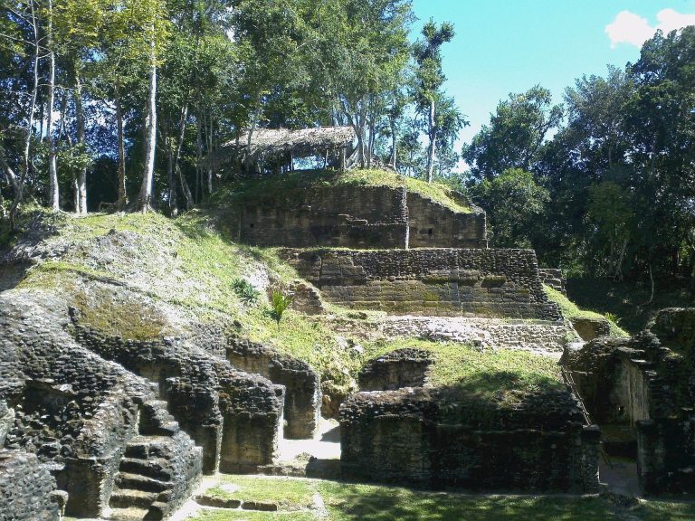
Caracol’s built landscape includes pyramids, temples, palaces, residential compounds, ballcourts, reservoirs, causeways, terraces, acropoleis, tombs, agricultural features, and administrative groups. Structures were generally arranged at regular intervals and incorporated into broad terrace systems. Causeways linked plazas, residential areas, and outlying termini, where residential, administrative, ritual, and elite groups formed parts of a settlement extending across approximately 177 square kilometres. At least 53 carved stone monuments are known, including 25 stelae and 28 altars, along with more than 250 burials and 200 caches.
Principal plazas and monumental architecture
Caana
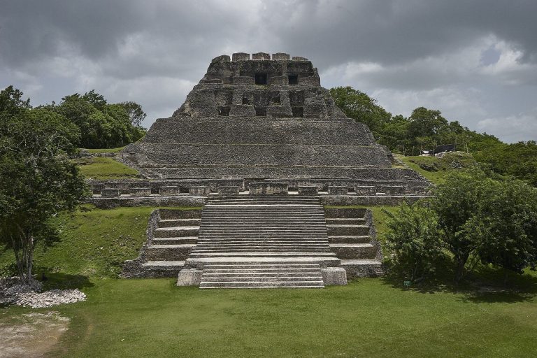
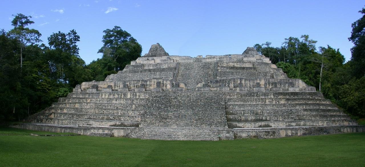
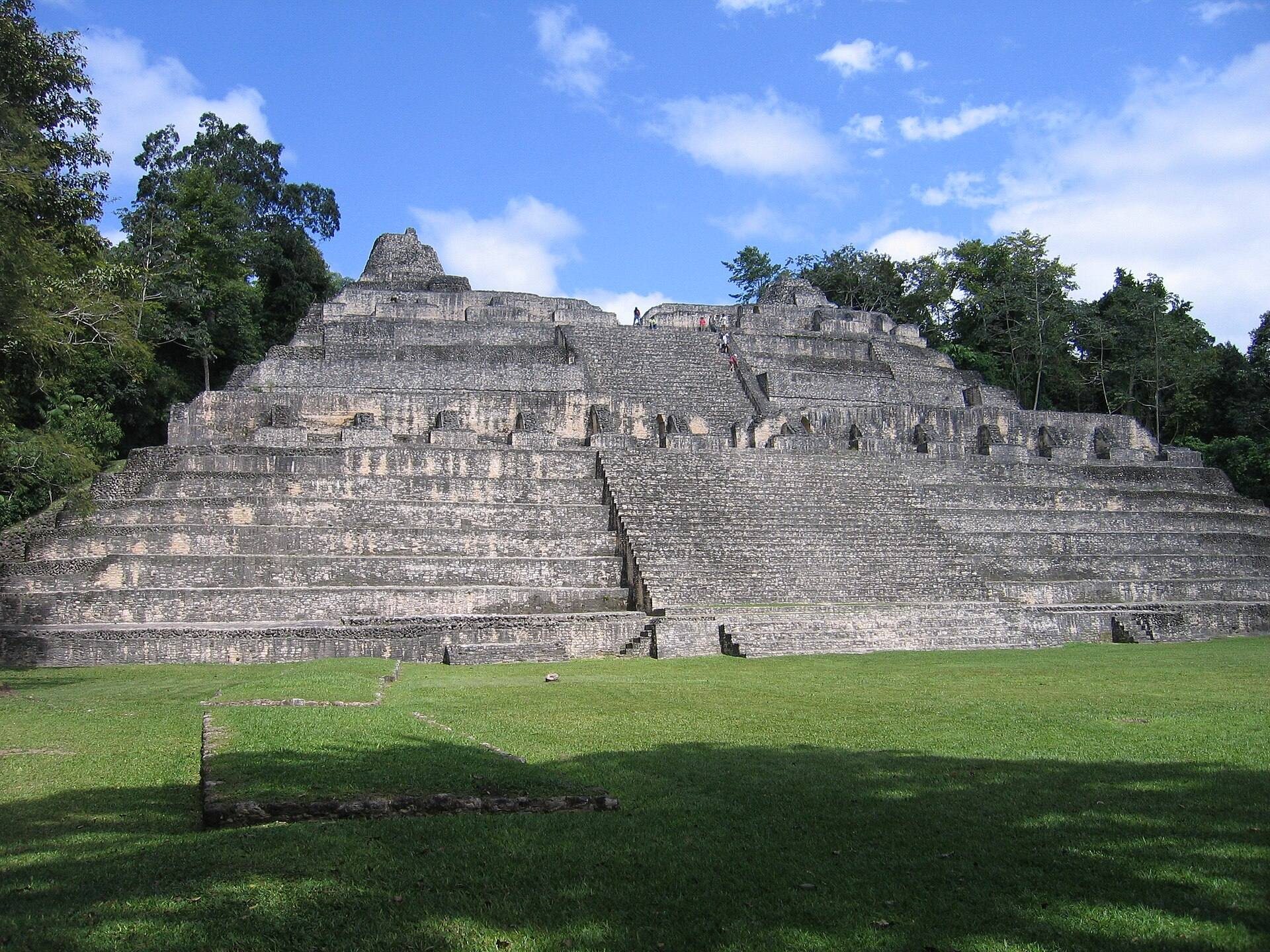
Caana, meaning “Sky Palace,” is the largest building at Caracol. It rises approximately 43 metres and is the tallest artificial structure in Belize. The building occupies the northern end of the B-Group Plaza and contains at least 71 rooms and 45 benches. First constructed near the end of the Late Preclassic, it was substantially raised during the Late Classic, with major work dating to approximately AD 650–696. Its final floor stands about four metres above an earlier floor, and its rooms have the character of palace spaces.
Caana was rebuilt under Lord Water and continued to be occupied and altered through the Classic and Terminal Classic periods. An elite woman’s large tomb was excavated in 1987, and later work identified additional tombs. Two re-entered tombs beneath side rooms show that the building remained in use after AD 700. K’inich Toobil Yopaat remodelled the summit during the first half of the ninth century, when stucco texts referring to Papmalil of Ucanal were added.
A-Group Plaza
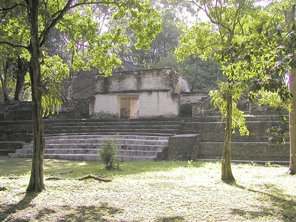
The A-Group Plaza is one of Caracol’s earliest major architectural groups. Temples occupy three sides, while a western range platform supports six structures. Structures A1–A7 surround the plaza, which was built over an earlier ceremonial E Group associated with approximately AD 70. Early dedicatory caches were placed in the plaza, including deposits connected with the completion of the earlier group. Ritual activity also took place behind structures, including a tomb with three cremated individuals, a twice-life-size stucco figure, and elaborate Late Early Classic caches.
Platform A1 supported a monument complex comprising Stelae 13, 14, 15, and 16 and Altar 7. Stela 13, associated with Yajaw Te’ K’inich I, is dated to AD 514. Stela 14 was erected by Yajaw Te’ K’inich II in AD 554 and shows a ruler holding a ceremonial bar. Stela 15 records K’an I’s accession and genealogy, while Stela 16 depicts K’an I and includes further genealogical information. Stelae 15 and 16 were later broken and buried beneath Altar 7, demonstrating a changing sequence of monument use within the plaza.
B-Group Plaza
The B-Group Plaza contains Caana, the B-Group Ballcourt, the Barrio palace compound, and other buildings on raised platforms. The eastern palace complex was undergoing major renovation when Caracol was abandoned. Several buildings contained Terminal Classic deposits or remained unfinished, preserving evidence of the site’s final period of activity.
Northeastern Acropolis
The northeastern acropolis was occupied from the Late Preclassic through the Terminal Classic and underwent major later modifications. A sealed deposit in its central plaza contained a Teotihuacan-style cremation dating to approximately AD 330. The deposit included twenty ceramic vessels, several severely burned, six heat-warped tanged points, other elite objects, and the remains of at least three individuals.
One of the acropolis’s largest buildings contained eight rooms and an Early Classic tomb with an adult buried with the head toward the east. The tomb had a perishable roof, indicated by the recovery of no vault stones. The combination of later alterations, tombs, and ritual deposits reflects the long use of this architectural group.
Monuments and ritual features
Stelae and altars
Caracol’s stelae and altars record royal accessions, genealogy, warfare, ritual action, and political relationships. Stela 1 stood behind Structure A1 above cached vessels and in front of a small transformational tomb containing three cremated individuals. Yajaw Te’ K’inich II erected it with Altar 1 for the k’atun ending of AD 593. Stelae 5, 6, and 7 originally stood in a line at the western front of Structure A13, a setting associated with dynastic ritual and possibly accession ceremonies. Stela 6, erected by Knot Ajaw in AD 603, originally contained more than 144 glyphs and paired portraits of Knot Ajaw and Lord Water.
Stela 7 and Altar 21 commemorate the AD 633 k’atun ending and describe earlier conflicts involving Tikal, Caracol, and the Snake polity, a political network associated with Calakmul. Stela 11, erected by K’inich Joy K’awiil in AD 800, records warfare and the capture of the lord of Ucanal. Stela 18 and Altar 12 describe K’inich Toobil Yopaat’s relationship with Ucanal, while Altar 12 shows Toobil Yopaat and Lord Papamalil seated on anthropomorphic head thrones. Stela 10, dated to AD 859, is largely composed of glyphs and is the last dated monument known from Caracol.
Giant Ajaw altars were associated with k’atun endings from the Early Classic through the Terminal Classic. Altar 3 dates to approximately AD 495, Altar 6 and Altar 24 were dedicated in AD 573, and Altar 17, near the summit of Structure A2, is the last known giant Ajaw altar at Caracol. Altar 17 has small glyph panels around a central Ajaw figure. A smaller Terminal Classic altar found beside the Barrio palace compound bears a large crescent-shaped glyph enclosing a seated female figure interpreted as the moon goddess. Another small altar from the southern summit of Structure A13 bears a date corresponding to AD 824.
Ballcourts
The A-Group Ballcourt is bounded by Structures A11 and A12. Its first construction belongs to the Late Preclassic, while later floors produced Late and Terminal Classic effigy censers. Altar 21 was placed at the center. The B-Group Ballcourt was built in a single construction episode and contains markers identified as BCM 2, BCM 3, and BCM 4. BCM 1 and BCM 2 form a stylistic pair: one presents a rabbit head opposite an image of the Sun God, while the other shows a jaguar head opposite a figure probably representing God N emerging from a shell.
Residential and civic groups
C-Group Plaza and South Acropolis
The C-Group Plaza was formed by Structures B59–B62, B64, and I19–I20. Most associated buildings date principally to the Late Preclassic, although some were built or modified during the Late and Terminal Classic periods. One collapsed square building contained raised benches and resembles a sweat house. A Late Classic tomb in the northern eastern shrine held seven individuals, prestige objects, and imported trade ceramics.
The South Acropolis flourished as a ritual area during the Late Preclassic, when censers were used there, and probably became an elite residential area in the Early Classic. Its buildings include Structures D7, D11, D16, D17, and D18 and several smaller southern platforms. Tombs contained Early Classic vessels, carved limestone bars, figurines, multiple individuals, and later crypt burials. One burial held two individuals dating to approximately AD 500, while another crypt contained two adults and vessels dating from the Late to Terminal Classic.
Northwest Group and Alta/Baja Vista
Structure F2 in the Northwest Group had been heavily looted before excavation. Investigations found two secondary burials in its core, two cist burials in front of the building, painted stucco decoration, and two earlier construction phases. West of the Northwest Group, the Alta/Baja Vista residential complex includes Structures F30–F42 and was occupied by Caracol’s secondary elite. Its excavated deposits span the Late Preclassic through the Terminal Classic and include ritual deposits, burials, caches, and earlier shrines.
Saraguate, Retiro, and Ceiba
The Saraguate complex lies on terraced ground approximately 350 metres east of the South Causeway. It was occupied from the Late Preclassic through at least the Late Classic and contained looted tombs, a Late Classic burial of a woman, a two-room tomb with four individuals, and a Late Classic face cache.
Retiro was a causeway terminus with an administrative plaza, low range structures, a second plaza linked by a 30-metre-wide causeway, pyramids, plain stelae and altars, and elite plaza groups on a hilltop. Its buildings date to the Early and Late Classic periods. Ceiba was another terminus on a high hill beyond a functioning reservoir. It contained a probable administrative plaza, range structures, a larger southern plaza with pyramids, a northern acropolis, and a causeway continuing toward the Guatemalan border and the La Rejolla terminus. Most excavated materials date to the Late Classic, with earlier ceramics at the northern Pescador group.
Causeways, terraces, and settlement
Causeways, reservoirs, and terraces organized Caracol’s extensive urban landscape. The causeways connected central plazas with residential districts and outlying administrative termini, while terrace systems incorporated buildings across the settlement. LiDAR survey revealed the scale of this infrastructure beneath forest cover and identified additional residential areas. With approximately 267 structures per square kilometre, Caracol’s settlement was densely organized, extending from monumental central groups into numerous residential and administrative communities.