Cahal Pech: A Maya Regional Center in Belize
Site at a Glance
- Rating
- 4.7
- Popularity
- Medium
- Country
- Belize
- Primary era
- Medieval
- External website
- Open
- Eras represented
- Iron Age, Classical, Medieval
- Civilizations
- Maya
- Site type
- City
On this page21 sections
History
Cahal Pech is a former Maya settlement on a limestone hill in southern San Ignacio, Belize, occupied continuously from approximately 1200 BCE until about 900 CE. During the Preclassic period, it developed into a regional center in the Upper Belize River Valley, where fertile soils supported agriculture and the nearby confluence of the Mopan and Macal rivers connected the settlement to exchange networks reaching the Guatemalan Highlands, the Caribbean coast, and the central Maya lowlands.
Early settlement and the Preclassic transformation
The earliest occupation belongs to the Cunil phase, which began around 1200 BCE. The community relied on subsistence agriculture, supplemented by hunting, fishing, and gathering. Its inhabitants produced high-quality pottery and stone tools and exchanged exotic goods. The settlement appears to have had a relatively egalitarian social structure, although competing leaders displayed status through communal feasting and other public activities.
During the Kanluk phase, beginning around 900 BCE, buildings made from wattle and daub gradually gave way to masonry construction. Monumental building, centralized planning, large labor demands, luxury ceramics, and specialized vessels indicate growing social hierarchy. By the late Kanluk phase, beginning around 650 BCE, distinct social strata had developed. Around the same time, inhabitants began moving from the hilltop into the surrounding area, initiating the settlement’s long expansion into the periphery.
These changes also reshaped Plaza B. A residential structure was demolished and replaced by a platform covering more than 300 square meters, which supported a residence of at least two buildings. Structure B4, originally a residence, was converted into a major Preclassic ritual building. Around 750 BCE, a pyramid was built west of Plaza B, replacing an earlier Cunil-period platform. Together with eastern Structures B1 through B3, it formed an E-Group, a Maya ceremonial arrangement with a western building facing structures to the east.
Royal and ceremonial development
During the Late Preclassic, the western pyramid of the E-Group was demolished and Plaza B was extended westward. An extensive royal residence was built, while the eastern part of the former E-Group became an Eastern Triadic Assemblage, a monumental arrangement centered on a large structure flanked by two smaller buildings. This group became the settlement’s principal spiritual center. From approximately 150 BCE, the royal dynasty used it as an exclusive burial place for members of the royal family, changing the plaza from a communal ritual space into a center of royal ancestor veneration and elite residence.
During the Xakal phase, Cahal Pech became a leading center in the Upper Belize Valley. Monumental architecture became more advanced, polychrome pottery was produced, and exchange networks operated across a wide geographic area. The settlement’s development shows how an early agricultural community was transformed into a stratified center with royal, ritual, residential, and administrative functions.
Classic-period expansion
The Classic period began around 300 CE, bringing further population growth and construction. Plaza A was remodeled, Plazas C, D, F, and G were enlarged, and the eastern ballcourt was built. Elaborate royal burials and imported Mexican obsidian demonstrate Cahal Pech’s participation in extensive trade networks.
Cahal Pech reached its greatest extent during the Late Classic. More than 140 architectural groups surrounded the central acropolis, and the settlement probably had approximately 2,000 inhabitants. It formed one of the larger communities among the closely spaced settlements of the Belize River Valley, whose combined population exceeded 24,000 at that time.
The settlement probably did not control a large political or administrative territory. Its domain may have consisted mainly of smaller nearby communities, while its relationship with other major centers remains uncertain. Cahal Pech may have been independent, may have belonged to the sphere of Naranjo, or may have maintained close relations with Caracol. A fragmentary graffito from Structure A1 mentions Naranjo, apparently in connection with the accession of a Cahal Pech ruler, but it does not establish the settlement’s political status. Similarities between inscriptions on jewelry from Cahal Pech and a jade ornament from Nim Li Punit also raise the possibility that the mother of Janaab’ Ohl K’inich, ruler of Nim Li Punit from 647 CE, came from Cahal Pech.
Abandonment and later ritual use
The Terminal Classic began around 850 CE and was marked by reduced construction, ritual activity, elite burials, and architectural and craft standards. Buildings were generally low, made largely of unworked stone, and lacked permanent roofs. The settlement was abandoned around 900 CE, although the reason remains unknown.
The acropolis retained spiritual importance for centuries afterward. Later artifacts are interpreted as evidence of rituals or pilgrimages, including a Maya-style burial of a child approximately twelve years old. Radiocarbon dating and the burial context place this interment most probably in the colonial period, between 1735 and 1805.
Rediscovery and archaeological research
The ancient name of the settlement is unknown. The modern name Cahal Pech means approximately “Place of the Ticks” in Yucatec Maya and was established during the first archaeological investigations in the 1950s, when the area was being used as pasture. Sherds and artifacts from mounds at San Ignacio were reported in 1916 and 1918, and the area was mentioned again in 1939.
American archaeologist Linton Satterthwaite carried out exploratory excavations in 1950, briefly described the site in 1951, excavated parts of the central area and ballcourt, and recovered several stelae. Severe looting led German archaeologist Peter Schmidt to undertake rescue excavations on Plaza B and Structure B1 from 1968 to 1971, uncovering important finds including burials. Joseph Ball began excavation and restoration in 1986 and proposed that Cahal Pech had been a subordinate seasonal residence of rulers based at Buenavista del Cayo rather than an independent polity.
The Cahal Pech Park Project was established in 1988 to support protection, research, and tourism development. Jaime Awe began continuous, coordinated excavations that year through the Cahal Pech Project and later directed restoration and research associated with Belize’s National Institute of Archaeology. The Belize Valley Archaeological Reconnaissance Project, founded in 1992, has coordinated research throughout the Belize River Valley since 2001, jointly with American Foreign Academic Research since 2006. The hill and adjoining area were placed under protection in 1992. By 2020, more than 80 percent of the built acropolis had been excavated.
Modern San Ignacio now surrounds the site, leaving the archaeological reserve within a narrow greenbelt. The peripheral settlement remains threatened by urban construction, agricultural activity, vandalism, illegal construction, looting, and the leveling of archaeological structures.
Remains
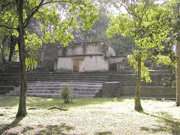
The archaeological reserve contains the settlement’s central core, an approximately rectangular acropolis defined by large walls, plazas, and structures raised above the surrounding area. It covers slightly more than 10,000 square meters and extends about 250 meters from east to west and 160 meters from north to south. At least 34 structures are arranged around eight plazas designated A through H. The buildings served administrative, ceremonial, and residential purposes, and the tallest, Structure A1, rises about 25 meters.
Acropolis layout and social organization
Royal residences were concentrated in the west, while administrative buildings probably bounded the northern and southern sides. The principal entrances and a ballcourt lay to the east. Walls enclosed the acropolis, which was open only at its eastern end. From the sixth or seventh century onward, construction increasingly separated the plazas. B, C, and H remained generally accessible, F and G became semi-accessible, and the western plazas A, D, and E could be reached only through controlled passages from Plaza B. This arrangement reflects increasing social stratification, with the western plazas probably reserved for the royal family and highest-ranking individuals, while other areas accommodated lower-ranking elites and public ceremonies, feasts, and markets.
Early buildings and ritual architecture
Cunil-period residences
The earliest settlement consisted of huts made from roughly plastered wattle and daub, with floors of compacted marl. These buildings probably served as living spaces, kitchens, and storage areas. In the northwest of Plaza B, a Cunil-period residence had a plastered courtyard and later acquired a paved platform in front of it. The platform closed to the east with another courtyard and is interpreted as a residence. Around 650 BCE, the complex was demolished and replaced by a platform of more than 300 square meters supporting a residence of at least two buildings.
Plaza B and the early E-Group
Around 750 BCE, a pyramid measuring approximately 20 meters north to south by 12.5 meters east to west was built west of Plaza B in front of the later Structure A2. It was the settlement’s largest building at that time. Together with contemporary eastern Structures B1 through B3, it formed an E-Group and marked the transition from early domestic architecture to monumental construction.
Structure B4
Structure B4 began as a Cunil-phase residential building. During the Kanluk phase it was converted into a major ritual building and became one of Cahal Pech’s most important Preclassic temples. Its transformation reflects the changing role of Plaza B as the settlement developed from a residential area into a prominent ceremonial and political center.
Plaza H and the eastern acropolis
Plaza H occupies the northeastern end of the acropolis beside the northern gate, with Plaza C immediately to its south. It was the last plaza to be excavated, with initial work beginning in 2006. The plaza originally contained ordinary residential buildings with thatched roofs. Its four surviving structures belong to the Terminal Classic, while earlier buildings were dismantled and covered during later construction. The construction of the royal tomb in Structure H1 changed the plaza into a funerary and ceremonial area.
Structures H3 and C3
Structures H3 and C3 stand on the northern and southern sides of Plaza H and were probably residences. Each measures approximately 19 meters in length and 4 to 5 meters in width.
Structure H1
Structure H1 is an approximately 50-square-meter, roughly L-shaped building in the northeastern corner of the plaza. Its first phase was a Late Classic platform for an unidentified structure, raised with vertically placed elongated stones and marked by boulders. In a later phase, the building was demolished and rebuilt with cut stone to create an underground tomb reached by several steps. The tomb contained numerous valuable offerings and was probably intended for Cahal Pech’s last ruler.
Plazas F and G
Plaza F lies southwest of the acropolis in front of the palace area. It is roughly rectangular and can be reached only through a narrow passage from Plaza B. Structure F1 stands on the defensive wall, while F2 separates Plaza F from Plaza G. Plaza G lies south of the acropolis between Plaza F and Plaza B. The defensive wall bounds it to the south and east, and access is through Plaza F. Structures G1 and G2 are incorporated into the wall.
Structure F1
Structure F1 has not been fully excavated. Test excavations indicate a high-status residence consisting of at least four buildings on a platform. It was probably established in the Late Preclassic and used until the Late Classic.
Structure F2
Structure F2 was probably founded during the Kanluk phase and underwent nine major rebuilding or replacement episodes through the Late Classic without major changes to its overall size or orientation. Including its platforms, it measures approximately 19 by 8 meters. Its plastered walls were initially about 50 centimeters high and were successively raised to approximately 130 centimeters. The final version was painted red.
The last visible form of F2 contains three rooms, each opening west toward the palace area and containing a bench at the rear. The building stands on two west-facing platforms reached by a staircase. Another staircase once led south to Plaza G but was later blocked. Paths connected its southern end to F1 and its northern side to Structure B5 and Plaza G. The roof was probably made from perishable materials rather than masonry. The occupants were once interpreted as palace servants, but they are now considered more likely to have been people of elevated status, perhaps distant royal relatives or skilled craft specialists.
Structure G2
Structure G2 adjoins Structure B4 and measures approximately 15 meters long, 10 meters wide, and 2 meters high. It passed through three building phases during the Early, Late, and Terminal Classic. Its first form stood on a slightly raised platform, was at least partly built of masonry, and probably had a perishable roof. The Late Classic successor was a double-vaulted building on a floor slab at least 9 meters long and 3.5 meters wide. It had a doorway toward the plaza, two rooms divided by a lengthwise wall, and a later second story.
The final version, built approximately between 750 and 850 CE, stood on a platform 21 meters long and at least 7.30 meters wide, raised about 1.70 meters above Plaza G. A second platform measured approximately 7.70 by 6 meters and was reached by a five-step staircase. The upper building probably used perishable materials. Its architecture and associated finds indicate that it most likely served public purposes.
Ballcourts and carved monuments
The eastern ballcourt formed part of the acropolis, while the western ballcourt stood outside the enclosure, slightly below the royal palace. The western court was probably built during the Late Classic and consists of two parallel, similar, three-stepped structures. WBC-1 measures approximately 16.5 by 7 meters and WBC-2 about 15 by 7.5 meters, with a playing court approximately 4 meters wide between them. Erosion and vegetation damaged both structures, which were repaired between 2018 and 2022.
The acropolis includes nine stelae, an altar, and the probable sweat bath B5. Five inscribed objects are known from the settlement, including a turtle shell, two rings, and a needle from a burial, as well as a now-lost graffito from Structure A1. These objects provide names and titles, while the graffito is the only substantial known text and refers fragmentarily to a relationship with Naranjo.
Peripheral settlement
The settlement extended for several square kilometers around the acropolis. Field survey and lidar, a laser-based method for mapping ground surfaces beneath vegetation, have identified at least 201 settlement complexes, together with platforms, chultuns, terraces, and pottery scatters in the northern, northwestern, western, southern, and southeastern areas. A chultun is a subterranean excavation cut into limestone and commonly used for storage or other purposes.
Peripheral settlement was denser to the north than to the south. Northern groups formed a band approximately 250 meters from the Macal River and probably marked the limit of regular flooding. Emergency excavations about 1.5 kilometers north of the acropolis identified Late Early Classic buildings near the river. Severe flooding between 200 and 300 CE buried them under mud, after which the area was probably abandoned for residential use. Modern urban growth and intensive agriculture have leveled many northern structures.
Investigated peripheral groups include Zubin, about 2 kilometers south, with surrounding groups and three plazas; Melhado, about 1 kilometer north, with 13 structures; Cas Pek, 150 meters west, with 12 structures; Tolok, 350 meters southeast, with 11 structures; Tzutziiy K’in, 2 kilometers west, with nine structures; Tzinik, 450 meters south, with nine structures; Zopilote, 600 meters south, with five religious structures and a raised road connecting it to the acropolis; Martinez, 2 kilometers south, with four residences; K’ik, 90 meters south of Plaza F, with three structures; Zotz, 25 meters southeast of K’ik, with four structures; and Figueroa, 400 meters southwest, with three structures.
A small museum at the archaeological reserve houses artifacts from earlier and ongoing excavations.