Caerlaverock Castle: A Medieval Scottish Fortress and Aristocratic Residence


Site at a Glance
- Rating
- 4.6
- Popularity
- Medium
- Country
- United Kingdom
- Primary era
- Medieval
- External website
- Open
- Eras represented
- Medieval, Early Modern
- Civilizations
- Kingdom of Scotland
- Site type
- Military
- Remains
- Castle
On this page18 sections
History
Caerlaverock Castle is a medieval Scottish fortress in the United Kingdom, completed in the later thirteenth century and developed through successive periods of military and aristocratic use. Its triangular plan and frontier position made it an important Maxwell stronghold near the English border, where it became involved in the Wars of Scottish Independence, the conflicts between Scotland and England over control of the Scottish kingdom.
Earlier fortifications and the first castle
Caerlaverock was preceded by several fortified sites in the surrounding area. A Roman fort stood on Ward Law Hill, while a British hill fort was in use around 950. The name Caerlaverock has Brittonic origins and refers to an enclosed or defensible place, although the precise meaning of its second element remains uncertain.
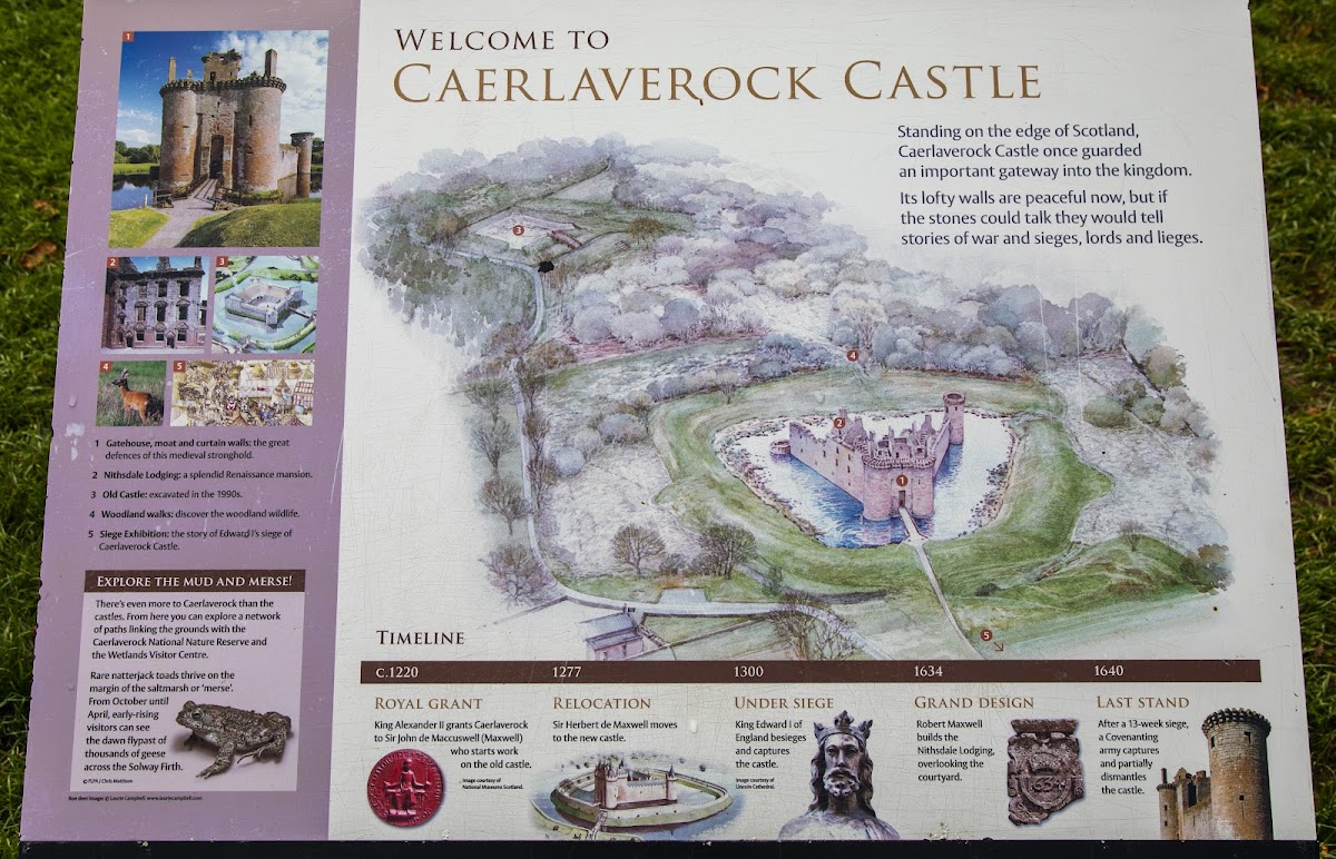
Around 1160, the lands of Caerlaverock were granted to the monks of Holm Cultram Abbey. Around 1220, Alexander II of Scotland granted them to Sir John Maxwell, who had been appointed Warden of the West March. Maxwell also served as Chamberlain of Scotland from 1231 to 1233 and began the first castle.
The earliest castle was a square stone fortification about 200 metres south of the present building. Construction probably stopped before it was completed, possibly because the site was damp. Work then moved north to a rock outcrop, where Sir Aymer Maxwell began the present castle. The new fortress was completed in the later thirteenth century and occupied by Herbert Maxwell, John Maxwell’s nephew.
Frontier stronghold and the 1300 siege
From the thirteenth century, Caerlaverock served as a Maxwell stronghold and helped control trade in a strategically sensitive region. Its location near the English frontier drew it into the Wars of Scottish Independence. In 1299, the garrison attacked Lochmaben Castle, which was then held by English forces.
In July 1300, Edward I of England besieged Caerlaverock with a large army that included 87 English barons and several knights from Brittany and Lorraine. Sir Eustace Maxwell commanded the garrison. The defenders resisted repeated attacks before surrendering, after 60 men had held the castle against the English army for a considerable period.
The siege produced the Siege of Caerlaverock, an Old French verse roll of arms. Its 956 Anglo-Norman verses describe the campaign, name English, French, and other noble participants, and record their heraldic devices. The manuscript is now preserved at the British Museum and provides a direct written record of the castle’s military history.
After the siege, English forces occupied Caerlaverock before it was returned to Sir Eustace Maxwell, the son of Herbert Maxwell. In 1312, Edward II granted Eustace an allowance of £20 to maintain the castle securely. Eustace later supported Robert Bruce, who became Robert I of Scotland, and dismantled the fortress to prevent its capture by the English. Bruce rewarded him for this action.
Reoccupation and reconstruction
Caerlaverock was inhabited again by 1337. Eustace Maxwell later supported Edward Balliol, a claimant to the Scottish throne who opposed the Bruce dynasty. Around 1355 to 1356, Sir Roger Kirkpatrick of Closeburn captured the castle for David II, Robert Bruce’s son and successor, and partly dismantled it. The Maxwells regained possession by the middle of the fourteenth century.
Sir Robert Maxwell rebuilt much of the castle between 1373 and 1410. Further work by Robert, 2nd Lord Maxwell, in the mid-fifteenth century probably included the reconstruction of the gatehouse. Around 1500, a new west range was added, extending the fortress beyond its earlier defensive core.
Religious conflict and the Maxwell feud
The Catholic Maxwells supported Mary, Queen of Scots, after her forced abdication in 1567. In 1570, an English Protestant force led by the Earl of Sussex besieged Caerlaverock and partly demolished it. The gatehouse was destroyed with gunpowder during the attack.
In 1593, John, 8th Lord Maxwell, repaired and strengthened the gatehouse during the Maxwell feud with the Johnstones of Annandale. John Maxwell was killed at Dryfe Sands. In 1613, the 9th Lord Maxwell was executed for the revenge murder of Sir James Johnstone, bringing the violent feud into the following generation.
The Nithsdale residence and abandonment
In 1619, Robert, 10th Lord Maxwell, married Elizabeth Beaumont, a cousin of the Duke of Buckingham. He was later created Earl of Nithsdale and appointed to the Privy Council of Scotland. He then developed Caerlaverock as a more elaborate aristocratic residence rather than solely as a military fortress.
The south and east ranges, known as the Nithsdale Lodging, were completed around 1634. Religious conflict soon brought another military crisis. In 1640, a Protestant Covenanter army besieged Caerlaverock for 13 weeks. The Covenanters were Scottish Presbyterians opposed to royal and episcopal religious policies. The castle surrendered, and the Earl and Countess of Nithsdale and their page were allowed to leave. Forty defenders identified as Maxwells were killed, while the south wall and a tower were demolished. Caerlaverock was never repaired or reoccupied.
State care and protected surroundings
By the mid-nineteenth century, Caerlaverock was held by William Constable-Maxwell, 10th Lord Herries of Terregles. In 1946, the 16th Duke of Norfolk, whose family had inherited the castle, transferred it to the state. Management was placed with Historic Scotland, and the castle is now cared for by Historic Environment Scotland.
Caerlaverock is protected as a scheduled monument. It lies within the Nith Estuary National Scenic Area and at the northern edge of Caerlaverock National Nature Reserve. The reserve covers saltmarsh, mudflats, and grazing land across 55 square kilometres and is internationally important for wintering waterfowl and wading birds, including barnacle geese.
Remains
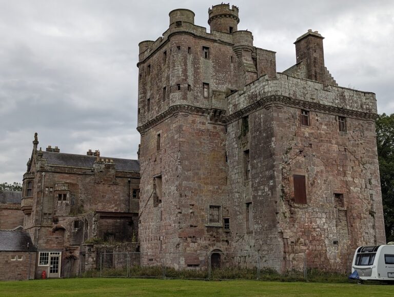
Caerlaverock occupies a low-lying former swamp on the flood plain of the River Nith. The castle has a triangular plan enclosed by deep, water-filled moats approximately 20 metres wide. Excavated material formed an earthwork rampart of similar width around the moat, separating the fortress from the surrounding marsh, while an outer court was formed on the north side. The gatehouse stands on natural rock, and the remainder of the castle rests on a specially created clay platform. Early sections were built from red sandstone quarried near Bankend.
Defensive walls and entrance
The curtain walls preserve the castle’s original triangular arrangement despite repeated sieges, demolitions, and rebuilding. Their bases date from the last quarter of the thirteenth century and survive at low level, while substantial sections on the east and west rise as high as parapet level. The three sides measure approximately 52 metres on the south and about 46 metres on both the east and west.
Northern gatehouse
The northern gatehouse consists of two large drum towers faced with ashlar, finely cut and regularly laid stone, and joined by an entrance passage. The west tower is largely original, while the east tower was largely rebuilt in the late fifteenth century. The upper levels are ruinous, but the towers rise approximately 15.5 metres above the drawbridge to the machicolations, projecting parapet structures with openings used to discharge materials onto attackers. The entrance retains a portcullis, a vertically descending fortified gate, and the hall above it was later subdivided.
South-west and south-east towers
Smaller drum towers occupy the south-west and south-east corners of the enclosure. Murdoch’s Tower at the south-west is largely complete. The south-east tower was reduced to its base during the Covenanter siege of 1640, when the castle’s defensive fabric was heavily damaged.
Courtyard ranges
Four ranges enclose the main courtyard: the gatehouse, west range, Banqueting Hall range, and Nithsdale Lodging. Their different construction dates create a small triangular courtyard between the buildings. Together, the surviving walls show the change from a thirteenth-century fortress to a residence with more elaborate domestic accommodation.
West range
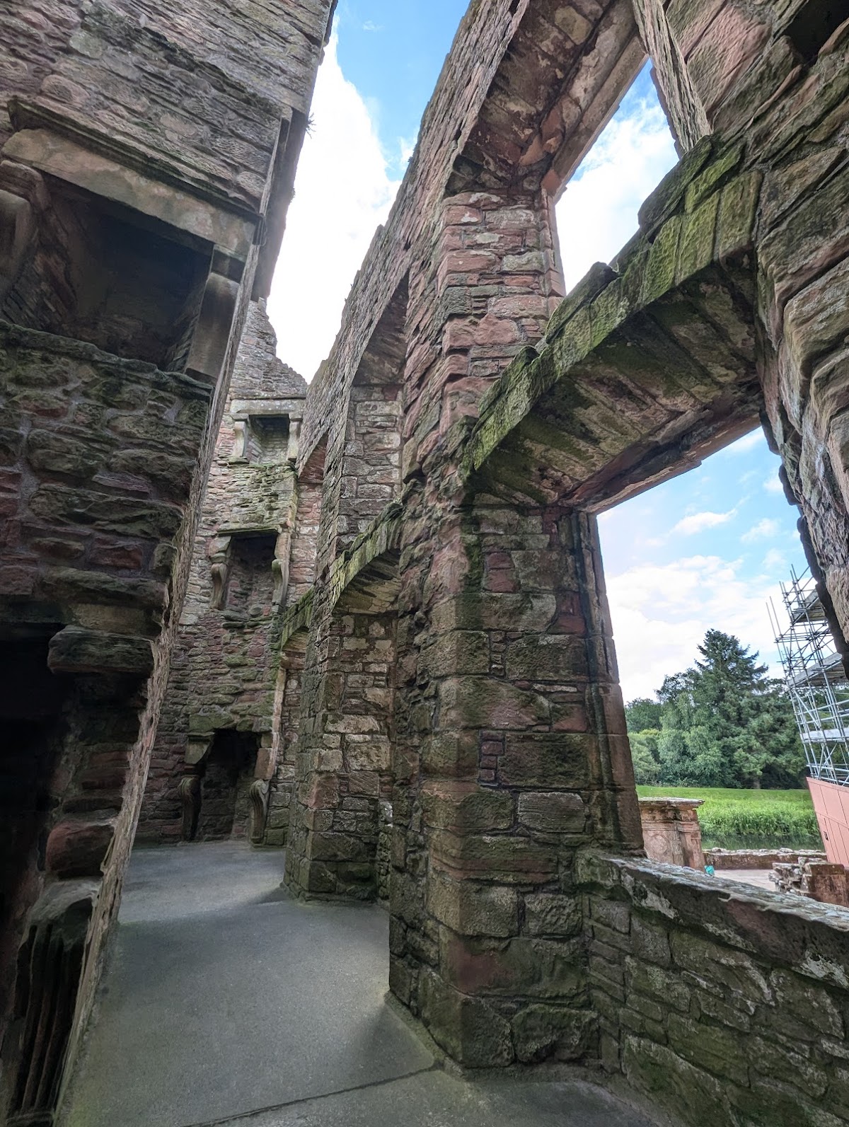
The west range dates from around 1500. It is roofless but largely complete, with rectangular rooms on two floors. Each room contains a fireplace, and the spaces were probably used as accommodation.
Banqueting Hall range
The south range, also called the Banqueting Hall range, survives as walls a few metres high or less. Artillery fire and later demolition during the siege of 1640 caused this substantial part of the residence to be heavily reduced. A large fireplace on the north wall indicates the former scale and status of the hall.
Nithsdale Lodging
The Nithsdale Lodging occupies the north-east side of the interior and was the last major part of the castle to be built. It is the most complete major section and retains an elaborate Renaissance facade from the 1630s. Renaissance architecture was a classical-inspired style that developed in Europe from the fifteenth century onward.
The facade has carved pediments above nine large windows, three smaller windows, and two doorways. Armorial imagery and symbolic sculptures enrich the exterior. Inside, the rooms are relatively small because a central fireplace and flue block occupies much of the structure. Kitchens and other service rooms were arranged on the ground floor, while the upper floors probably contained private apartments.
Moat landscape and siege evidence
Moat and surrounding landscape
The moat and earthwork rampart remain central to the castle’s physical form. Their construction helped define the fortress within the former swamp and separated the triangular enclosure from the surrounding flood plain. Beyond the castle, the adjacent nature reserve contains saltmarsh, mudflats, and grazing land that support internationally important populations of wintering waterfowl and wading birds.
Caerlaverock siege roll
The Caerlaverock siege roll survives as a manuscript of 956 Anglo-Norman verses. It describes the 1300 siege and presents the heraldic devices of the participants. Preserved at the British Museum, it connects the surviving masonry with the names, actions, and military encounter associated with one of the castle’s defining historical episodes.