Bangudae Petroglyphs: Prehistoric Evidence of Whaling and Maritime Culture
Site at a Glance
- Rating
- 4.4
- Popularity
- Low
- Country
- South Korea
- Primary era
- Stone Age
- External website
- Open
- Eras represented
- Stone Age, Bronze Age
- Civilizations
- Unclassified
- Site type
- Civic
- Remains
- Rock Art
On this page10 sections
History
The Bangudae Petroglyphs are prehistoric rock engravings beside the Daegokcheon in Ulsan, South Korea. Produced during Neolithic and Bronze Age activity between approximately 6000 and 1000 BC, they are regarded as the earliest known evidence of whaling and as important evidence for prehistoric maritime culture in the northern Pacific.
A prehistoric record of animals and hunting
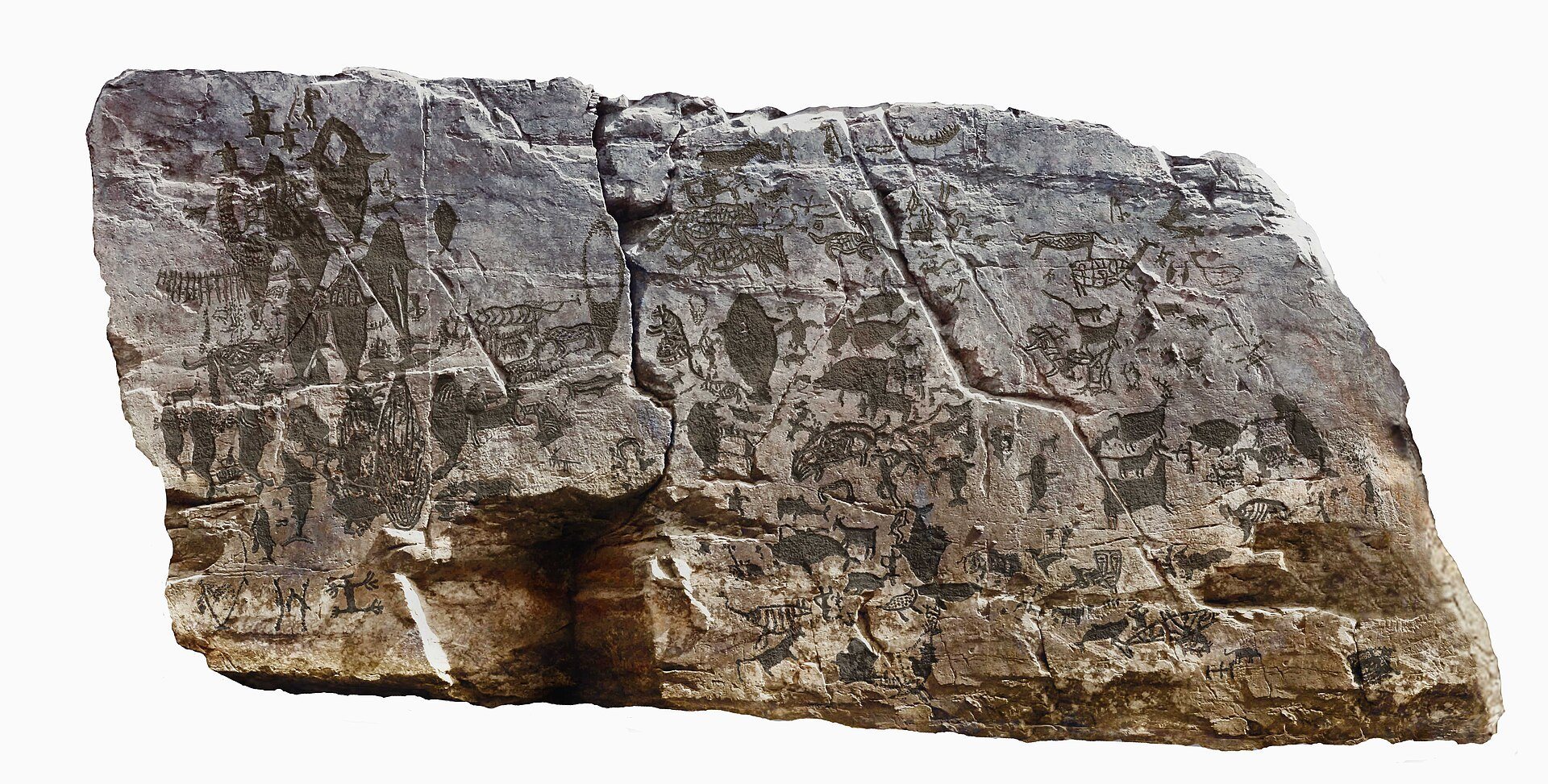
The carvings were made over more than one period. Overlapping techniques and images indicate successive phases of production, while the subjects preserve knowledge of animal species, animal ecology, hunting methods, food, and fertility. The imagery includes whales and other marine animals, deer and predators, human figures, boats, hunting scenes, and signs. Repeated images of pregnant marine and land animals have been interpreted as expressions of fertility and the desire for abundant food.
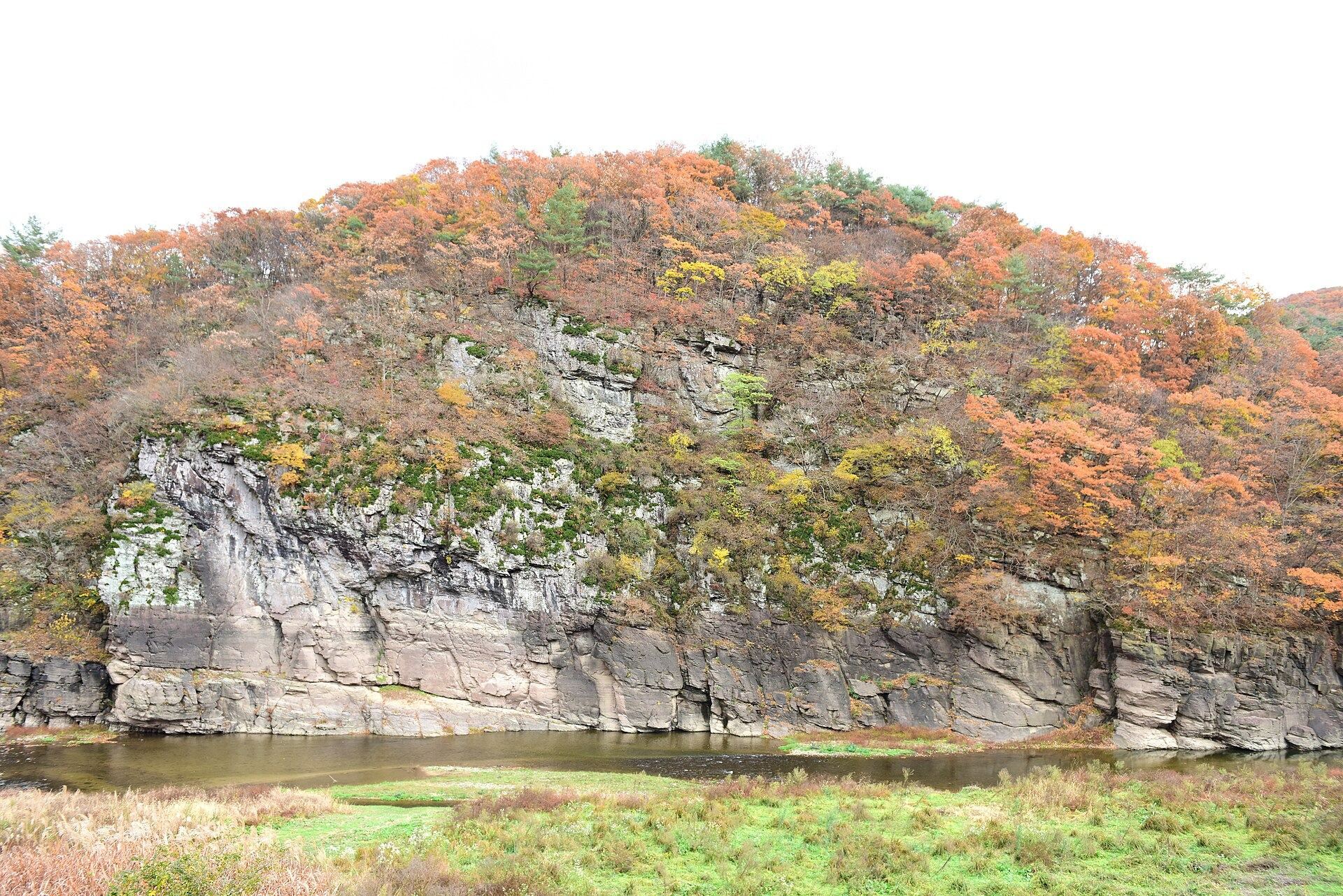
The name Bangudae refers to a nearby rock formation traditionally understood to resemble the back of a turtle. The engraved cliff stands beside the Daegokcheon, a tributary of the Taehwa River that flows eastward to the East Sea at Ulsan.
Discovery and heritage recognition
The carvings were discovered in December 1971 by Dongguk University professor Mun Myeong-dae, Korea University professor Kim Jeong-bae, and Chungbuk National University professor Lee Yong-jo. While reexamining the Cheonjeon-ri Petroglyphs, they followed a local report about a cliff bearing a tiger image. Travelling downstream by boat, they found smoothed rock surfaces covered with engravings.
Ulsan designated the site a monument in 1982. On June 23, 1995, it became National Treasure No. 285, a South Korean designation for cultural property considered especially important to the nation’s history, art, archaeology, or science. The site joined the UNESCO tentative list in 2010 as part of the Daegokcheon Petroglyph Group, entered the priority-registration list on February 16, 2021, and was inscribed in 2025 with the Cheonjeon-ri Inscribed Rocks and Petroglyphs as “Petroglyphs along the Bangucheon Stream.” The inscription recognizes the site for an outstanding work of human creative genius and as exceptional evidence of a vanished cultural tradition.
Flooding and conservation
The Sayeon Dam was built between October 1962 and December 1965 to supply industrial and drinking water to Ulsan. Because the petroglyphs were discovered after the dam was completed, their periodic inundation became a major conservation problem. The dam was expanded between 1999 and 2002, while the later construction of Daegok Dam upstream reduced the duration and frequency of flooding to some extent.
Cultural authorities and Ulsan authorities have debated how to preserve the carvings while maintaining the dam as a water source. Proposals included dismantling the dam, installing gates, building temporary or ecological embankments, constructing a kinetic dam, and diverting the watercourse through a tunnel. Temporary-embankment proposals submitted in 2009 and 2011 were rejected because excavation, blasting, and vibration could damage the surrounding rock and hinder World Heritage inscription. An ecological embankment proposed in 2017, measuring 357 meters in length and 65 meters in height and positioned 30 meters from the carvings, was rejected on July 20 that year.
A kinetic-dam plan introduced by architect Ham In-seon was accepted in principle by the Cultural Heritage Administration and Ulsan in June 2013. Ground surveys, safety assessments, and preliminary tests followed, but simulations in December 2015 and April and May 2016 failed when water leaked near joints in transparent panels under pressure. The Cultural Heritage Committee halted the project in July 2016 after more than three years of work and expenditure of 2.8 billion won.
Since 2013, the Sayeon Dam’s water level has been lowered to 52 meters or below when possible, although typhoons and intense rainfall caused further flooding in 2016, 2018, and 2019. The rock surface received inadequate evaluation or protection for at least nine years after discovery. A 2009 investigation classified its weathering as stage five of six, immediately before a soil-like condition. By 2016, only about 20 to 30 figures were clearly visible to the naked eye, compared with roughly 300 during the 1995 National Treasure investigation.
The Ulsan Petroglyph Museum, established as an exhibition hall in 2008 and elevated to museum status in 2010, supports research and public understanding of the carvings. The Ulsan University Bangudae Petroglyph Site Conservation Research Institute was established in October 2011 and has collaborated with the Korean Rock Art Association and other research institutions.
Remains
Cliff setting and carved surfaces
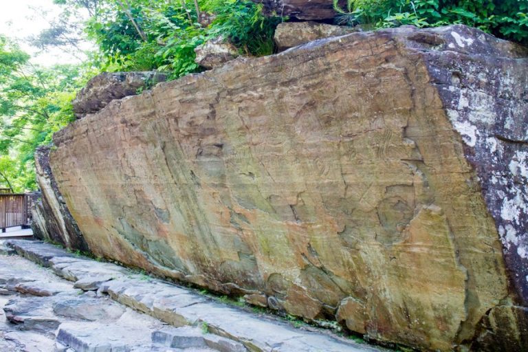
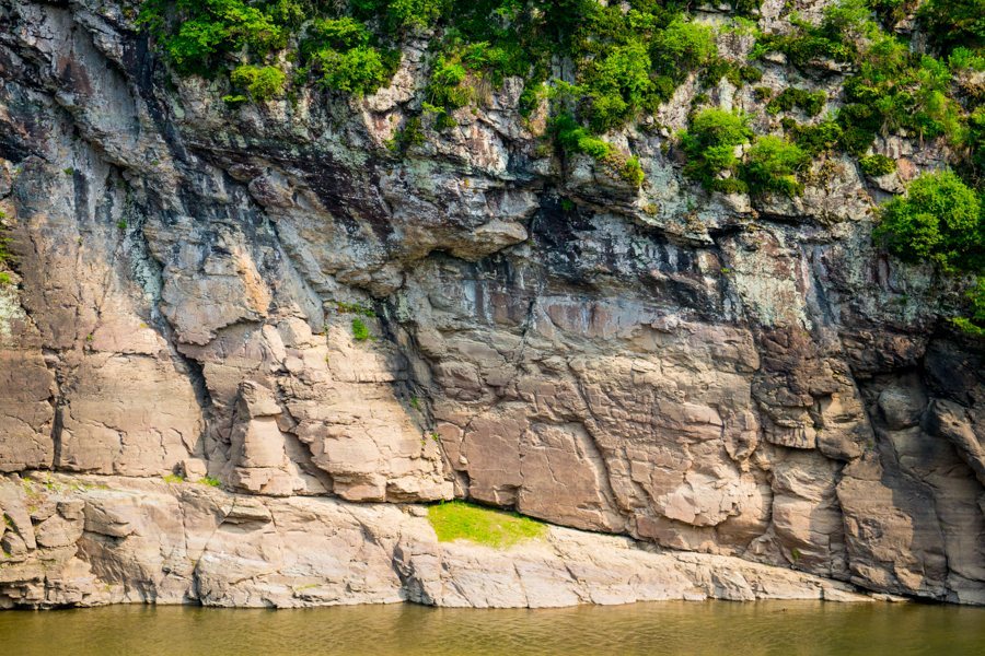
The engravings occupy broad, nearly vertical rock surfaces in a cliff-lined part of the Daegokcheon valley. The principal panel is about 8 meters wide and 5 meters high, while smaller engravings occur on roughly ten nearby rock faces. An overhanging upper rock shelters the main panel, creating a natural rock shelter, a recessed or overhanging part of a cliff that offers partial protection from weather.
The rock consists of shale and hornfels, and the surrounding bedrock belongs to the Cretaceous Daegu Formation, a sedimentary formation containing shale and mudstone. Calcite within the carved surface can react readily with water and dissolve. This material has made the relationship between the panel and the reservoir especially important to the survival of the images.
Animals, people, and maritime scenes
Marine animals and whaling
More than 300 engravings are recorded, including 237 recognizable figures: 97 land animals, 92 marine animals, 17 people, six boats, and six hunting or fishing implements. Whales and other cetaceans, the group that includes whales, dolphins, and porpoises, form the dominant subject. One count identifies 62 whale images, about 26 percent of all figures and 75 percent of the marine-animal figures.
The marine animals include northern right whales, humpback whales, right whales, gray whales, sperm whales, sea turtles, seals, shark-like fish, salmon-like fish, and seabirds. The whales appear in swimming groups, with calves, breaching, migrating, and accompanied by seabirds. One image may show a whale overturning a boat. Horizontal tails, eyes, mouths, longitudinal body lines, and differing body shapes allow several whale forms to be distinguished.
Three turtles near the upper left of the principal face appear to guide a group of swimming whales. Fish are shown in side view, while salmon-like fish leap above the water. One later image may represent a wooden fence or fish pond, although that interpretation remains uncertain. Boats, rafts, harpoons, nets, floats, and fish pounds appear among the maritime equipment. In one scene, approximately 5 to 17 people in curved boats surround a whale. Lines connect the boats’ semi-circular bows and sterns to harpoons embedded in the whale and to floats.
These arrangements of boats, harpoons, ropes, and floats closely resemble equipment used in later Indigenous whaling traditions. Together, they provide detailed physical evidence for prehistoric whaling and the maritime technology associated with it.
Land animals and human figures
Land animals include sika deer, red deer, musk deer, roe deer, water deer, tigers, leopards, lynxes, leopard cats, wolves, foxes, raccoon dogs, dholes, and wild boars. Deer and predatory animals are concentrated mainly on the right side of the principal rock face. Body shape, skin patterns, tails, legs, and shoulder lines distinguish several species, many of which were important hunting prey.
Most land animals appear in profile, emphasizing their four-legged forms. Some scenes may refer to reproduction, seasonal change, or animal molting. Human figures include full-body profiles with exaggerated sexual features and frontal figures with mask-like faces and outstretched limbs. Some people use bows, raise their arms, or play a long rod-like instrument. The masked figures and musicians may represent mythical or religious persons, while the scenes as a whole have been interpreted in relation to hunting and religious activity.
Engraving techniques and preservation
The images combine figurative scenes with signs, concentric circles, diamond-shaped patterns, and other marks. Two principal techniques were used with hard stone tools. In surface carving, an outline was cut and the interior was evenly pecked or scraped away. In line carving, outlines and characteristic animal features were rendered through lines or dots. Surface carving is generally associated with the Neolithic period, the later part of the Stone Age, while line carving is generally associated with the Bronze Age. Later line carvings sometimes overlie earlier surface carvings.
The marine and land-animal groups emphasize different ecological settings and hunting methods. Their arrangement has been interpreted as a long-term means of transmitting knowledge about animals and hunting across generations. Archaeological deposits known as shell middens, formed largely from discarded shells and other remains of human activity, together with animal bones and related artifacts from southeastern Korea, have helped date the imagery and interpret prehistoric whaling.
Flooding begins when the Sayeon Dam reaches about 52 meters and completely submerges the carvings at about 57 meters. The spillway is approximately 60 meters high, about 8 meters above the lowest part of the carved surface, so rising reservoir water can inundate the panel. The site is submerged during June through August when water levels rise, with one estimate placing the average duration at approximately 38 days.
Water moss frequently adheres to the rock, and submerged areas have weathered about ten times faster than rock remaining above water. Repeated wetting and drying has eroded the calcite surface and reduced the visibility of the imagery. The alternating exposed and submerged condition of the panel, together with algae or water moss, remains the central physical threat to the surviving engravings.