Aventicum: Capital of the Helvetii and Roman Colonia in Switzerland


Site at a Glance
- Rating
- 4.6
- Popularity
- Low
- Country
- Switzerland
- Primary era
- Classical
- External website
- Open
- Eras represented
- Classical, Medieval
- Civilizations
- Celtic, Roman
- Site type
- City
On this page22 sections
History
Aventicum is the ancient Roman city at Avenches in Switzerland, developed by the Helvetii and transformed into a major Roman centre around the turn of the 1st century AD. It became the capital of the Helvetii, a Celtic people whose territory broadly corresponded to the Swiss Plateau, although its precise foundation date remains uncertain. The settlement’s origins may be connected with the failed Helvetian migration of 58 BC and the population’s forced return, while an earlier hillfort at nearby Bois-de-Châtel was destroyed in the early 1st century AD.
Helvetian beginnings and Roman development
Late Celtic burials and pits have repeatedly been found southwest of the later urban quarters. During the second half of the 1st century BC, Bois-de-Châtel supported an oppidum, a fortified settlement often placed on elevated ground. Its destruction in the early 1st century AD may have led some of its inhabitants to move to Aventicum. Much of the later city’s population was probably Helvetian, and the Helvetian elite retained their social position while becoming among the first members of the community to receive Roman citizenship.
By approximately AD 5–6, a port had been established on Lake Murten. An orthogonal street grid was also laid out, dividing the city into more than 60 insulae, or urban blocks, whose development continued into the 2nd century. Aventicum acquired a forum, public baths, at least eight temples, and cemeteries outside its exits. Its population has been estimated at about 20,000 during the 1st century AD. For part of the early Roman period, the city was probably known as Forum Tiberii.
A first period of prosperity came during the reigns of Tiberius and Claudius, approximately in the 30s–50s AD. A larger-than-life sculptural group representing members of the imperial family then adorned the forum. The city lay far from the imperial frontiers and was therefore relatively protected from the political crises that affected other parts of the Roman world during the early 3rd century.
Colonia and monumental expansion
In AD 71/72, Emperor Vespasian elevated Aventicum to colonia status, a privileged form of Roman civic settlement associated with citizenship, land allotments, veteran settlement, and the spread of Roman administrative and cultural practices. The city received the name Colonia Pia Flavia Constans Emerita Helvetiorum Foederata. Vespasian’s father had lived and worked at Aventicum, and Vespasian himself had spent part of his life there.
The new status initiated an extensive programme of public construction. It included a city enclosure more than 5.5 kilometres long, new or expanded gates, the theatre, the amphitheatre, and the Cigognier sanctuary. The forum baths were also built from AD 77. These projects reshaped Aventicum as a monumental Roman city while preserving an important role for the Helvetian community within its civic life.
Damage, decline, and Christian continuity
Alemannic incursions in AD 275 caused extensive damage at Aventicum. Construction and fortification nevertheless continued during the 4th century, particularly around the theatre. The amphitheatre and theatre were converted into fortified places during the later Roman or early medieval period, while other ancient monuments became sources of building stone.
Aventicum remained an episcopal see until the 6th century. In AD 592, its last bishop, Marius, was transferred to Lausanne, after which the city declined and was increasingly remembered as a ruined settlement. Christian activity continued in the former Roman acropolis during the 6th century, preserving a religious use of part of the ancient urban area after the city’s political importance had diminished.
Rediscovery and archaeological investigation
Interest in Aventicum’s remains began in the 16th century. Limited excavations followed from the 18th century, and systematic exploration began after the Association Pro Aventico was founded in 1885. The Roman Museum was established in 1824 and has occupied the medieval tower built over the amphitheatre since 1838.
During the 20th century, excavations and restoration focused on the theatre, the Cigognier sanctuary, the gates, and a surviving wall tower. A rescue-archaeology programme was organized under Pro Aventico in the late 1960s, particularly in response to road construction, under the direction of Hans Bögli. Roman remains discovered during construction of the A1 motorway in 1985 led to the road being moved in 1987 to avoid the archaeological area. Later work exposed parts of the urban blocks, the forum and temple area, a large palace, and infrastructure beyond the walls, including a canal, a road from the lake, cemeteries, and aqueducts.
The permanent exhibition in the medieval museum tower was reorganized after structural and museographical work began in 2016, with the new presentation mounted from 2018. It presents Aventicum’s population and territory, the forms of central Roman power, archaeological finds, and a topographic model of the ancient city. Among the city’s distinctive discoveries are 1,829 ceramic graffiti, including personal names, messages, drinking-related phrases, notes about vessels and their contents, and figurative or geometric drawings.
Remains
City plan and defensive enclosure
Aventicum was organized around a regular grid of streets and more than 60 urban blocks. The Roman city extended across approximately 228–230 hectares. Its cemeteries lay outside the urban exits, and its port on Lake Murten formed part of the wider system linking the city with the lake. In waterlogged areas, builders drove oak piles into the ground to stabilize foundations. Many of these timbers survived and have been dated by dendrochronology, a method that compares annual tree rings with established sequences.
City wall
The enclosure followed the ridge of the Donatyre slope to the south, surrounded the hill of present-day Avenches to the west, bordered marshy ground to the north, and followed a break of slope to the east. It was more than 5,500 metres long. The wall was about 3 metres wide at its foundation, 2.4 metres wide above ground, and approximately 5 metres high. A wall-walk was protected by angled merlons about 2 metres high, with crenels approximately 1.9 metres long. A ditch about 3.8 metres wide and 1.6 metres deep lay roughly 2 metres outside the wall, except across the marshy plain.
The enclosure was built mainly from small blocks of yellow limestone. Sandstone formed the coping stones of the merlons and crenels and paved the wall-walk. Approximately 200,000 cubic metres of Jura limestone were transported by barge from the northern shore of Lake Neuchâtel and then carried by cart to the building sites. The whole construction project is estimated to have taken about twelve years. Several sections survive as ruins, while the sector between the East Gate and Tornallaz has been restored and a short section near Tornallaz has been fully reconstructed.
Tornallaz tower
Tornallaz, tower 2 of the city wall, is the only one of its 73 towers preserved to substantial height. In Roman times it consisted of a circular room with narrow windows and two entrances connecting it with the curtain walls. Its later use as an observation and signalling post led to repeated maintenance, alteration, and heightening. Early-20th-century restoration added an internal wooden stair, reconstructed an adjoining curtain section, restored the city-side entrance, and repaired the Roman masonry up to the wall-walk.
The tower displays two markedly different building techniques. The Roman masonry consists of regularly laid small yellow limestone blocks, while the medieval upper structure uses more loosely arranged stone mixed with fragments of tiles and bricks. Sockets for floor beams installed at different periods remain visible in the walls.
East Gate
The East Gate was associated with a new route probably laid out under Vespasian when Aventicum became a colonia. It stood on higher and more secure ground than the older route across the plain and was probably built before the adjoining sections of the city wall, in the early 70s AD. The gate measured approximately 28 metres wide by 26 metres deep. At its centre was a circular courtyard 11.6 metres in diameter, served by two vaulted carriage passages, each originally 3 metres wide, and two pedestrian passages, each 2.1 metres wide.
Internal corridors led to two projecting polygonal towers and to a gallery around the courtyard. Small yellow limestone masonry formed the main structure, while large sandstone blocks were used at the tower bases, around openings, and at the passage thresholds. The façade probably carried at least two superimposed architectural orders. Fragments of capitals, entablatures, sandstone reliefs, and an inscription survive.
West Gate
The West Gate marked the edge of the colonial urban territory on a route linking Aventicum with Rome and the wider road network. Its plan has not been fully excavated, but it is thought to have resembled the East Gate, with two carriage passages, two pedestrian passages, two internal corridors, and two polygonal towers on circular foundations.
The gate was constructed from small yellow limestone masonry reinforced by large sandstone blocks at the bases and corners of the towers. Its façade probably carried architectural orders made from large blocks. Although its form was military in appearance, it probably served mainly to regulate movement and protect the city from brigands rather than withstand a major assault.
Places of public performance
Amphitheatre
The amphitheatre was built in two stages. The first, probably dating from the beginning of the 2nd century, used the slope to form an embankment for the seating, perhaps with much of the seating made from wood. Masonry was concentrated in the stairs, arena walls, upper walls, and axial entrances. This phase measured 98.85 by 85.94 metres, excluding the forecourt, and contained an arena measuring 51.63 by 38.40 metres. About 9,000 spectators could occupy its 24 tiers.
Small yellow limestone rubble formed the principal construction material, while sandstone was used for thresholds, a service corridor, and the facing of the podium. During the last third of the 2nd century, the building was enlarged with stone seating, a perimeter façade containing niches, and a monumental eastern portal made from large blocks. The second phase measured 105.01 by 92.11 metres, excluding the forecourt and eastern portal, and held approximately 14,000 spectators in 36 tiers.
In this later phase, small yellow limestone rubble was covered in places with plaster painted to imitate red masonry. The seating and eastern portal used large blocks of shelly sandstone, while columns, bases, and capitals were made from white Urgonian limestone. The building was later incorporated into defensive arrangements during the late Roman or early medieval period.
Theatre
The theatre was built at the beginning of the 2nd century on ground previously occupied by scattered habitation. Its seating area and orchestra extended beyond a semicircle, while a reduced stage building stood before a straight façade wall. The stage itself was probably a simple wooden platform. Performances may have included comedies, tragedies, burlesque farces, and pantomimes.
The theatre also had religious and political associations. A sacred fountain occupied a niche below the seating, and probable traces of an altar lay in the orchestra. Its alignment with the Cigognier sanctuary suggests that performances may have been connected with the imperial cult, the public veneration of the emperor and imperial household within Roman civic and religious life.
The theatre measured approximately 105.96 metres in diameter. Its orchestra was 20.65 metres across, with a north-south extension of 22.58 metres. The stage building measured 13.4 by 7.6 metres, and around 11,000 spectators could be accommodated on about forty tiers. Eleven passageways led to the seating and served two horizontal corridors. A platform 2.7 metres wide at the front was reserved for prominent citizens.
Built against the Donatyre slope, the theatre combined earthworks with small yellow limestone masonry. The seating area was largely a solid embankment, while masonry was concentrated in the access corridors and the walls supporting the sides and front of the seating. At least some seats were made of shelly sandstone, and the higher tiers may have been wooden. Yellow stone formed the stage building and straight façade, while sandstone was used for arches, entrances, and thresholds. Several repairs and alterations remain difficult to understand. During the last third of the 3rd century, the theatre became a fortified position surrounded by a deep ditch, a use that continued until the middle of the 4th century.
Sanctuaries and temples
Cigognier sanctuary
The Cigognier sanctuary was the largest sanctuary at Aventicum. Construction began in AD 98, when oak piles were used to support the foundations. The sanctuary may therefore have been added under Trajan rather than included in the city’s original plan. It probably served the imperial cult of the Civitas Helvetiorum, the Roman civic community of the Helvetii, and may also have accommodated Romanized Helvetian deities. Its association with the theatre and the discovery of a gold bust of Marcus Aurelius in one of its drains support this interpretation.
The sanctuary measured 111.58 by 118.80 metres. A broad courtyard with an axial avenue led towards a temple at the north, while porticoes surrounded three sides. A southern enclosure wall and forecourt completed the complex, and a gate in the southern wall created an axial connection with the theatre and the east-west road.
The temple stood on a high podium and had an eight-column porch. It measured 42.17 by 27.36 metres and was approximately 23.1 metres high, including its 2.4-metre podium. The surrounding porticoes measured 64 by 83.35 metres and reached about 19.5 metres in height, including their 2.4-metre podium. The forecourt measured 15.14 by 104.58 metres.
Massive small yellow limestone masonry rested on oak piles and was carefully drained. Sandstone formed the podium facing and portico steps, while white Urgonian limestone, used to imitate marble, formed the temple elevation, portico façades, and interior paving. Imported and local coloured stone veneers, sculpted cornices, marine monsters, canthari, marine-dragon friezes, and finely carved Corinthian capitals, probably painted, enriched the complex.
One column survives in place. It shows that the porch and porticoes interpenetrated, creating an internal route that was probably used for processions rather than providing direct access from the porticoes to the courtyard. Two secondary entrances stood at the ends of the northern portico. The modern name Cigognier comes from a stork’s nest shown on the column in a 1642 engraving. The nest was removed during the 1978 restoration, but the name remained.
Temple of the Grange des Dîmes
The Temple of the Grange des Dîmes was built in the late 1st or early 2nd century on the site of a smaller fanum, an indigenous or Gallo-Roman temple, dating from the first half of the 1st century AD. Its design combined Roman architectural forms with a Celtic-derived square cella, the principal sacred chamber, surrounded by a perimeter gallery.
The sanctuary enclosure contained an altar, a sacred well, and a canopy that probably protected a statue. The temple was probably dedicated to Mercurius Cissonius, a Gallo-Roman form of Mercury associated here with travel and commerce, perhaps alongside the Lugoves. It stood near the baths of insula 19, which may have been dedicated to Dea Aventia, a local deity associated with Aventicum’s name and religious tradition, and near the Cigognier sanctuary.
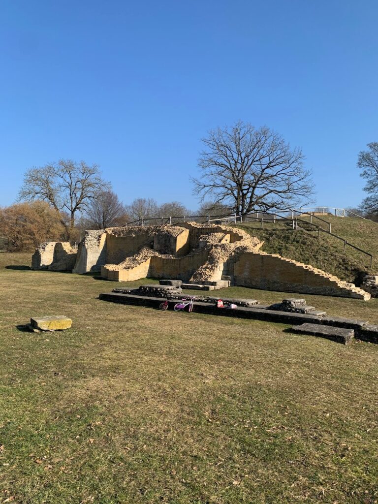
The excavated area preserves the foundations of the southern cella wall, measuring 10.8 by 9.4 metres, and part of a podium measuring 20.2 by 20.4 metres. The positions of the altar and sacred well can be seen, together with a partially reconstructed canopy. The rest of the temple lies beneath Jomini Avenue. The rear of the podium is marked north of the avenue, and the remaining plan is indicated in the pavement.
The reconstructed temple had a podium about 1.8 metres high supporting a tower-like cella approximately 20 metres high with a four-sided roof. The surrounding gallery had columns about 0.51 metres in diameter and 4.5 metres high, with an entablature about 1.16 metres high. A four-column porch interrupted the façade. Small yellow limestone masonry formed the cella walls and podium core, while large sandstone blocks faced the podium. Columns, entablatures, and the upper structure used large yellow limestone blocks, and sandstone formed the paving and steps. Traces of painted plaster may survive inside the cella, and a monumental gilded bronze roof ornament is preserved in the museum.
Baths and administrative buildings
Forum baths
The forum baths, also called the Baths of Perruet, occupied the whole of insula 29 immediately east of the forum. Built from AD 77 as part of the colonial building programme, they may have been funded by the Romanized Helvetian Camilli family. The complex provided bathing, massage, cosmetic care, exercise, socializing, listening to speakers, and possibly access to a library.
The main building measured approximately 52 by 32 metres. Its three principal rooms extended from east to west. The frigidarium, or cold room, had two cold-water basins in small eastern apses. The tepidarium, or warm room, was heated from below by two furnaces. The caldarium, or hot room, was incompletely excavated but was heated beneath the floor and through its walls by two large furnaces. It contained two bathtubs and two basins, while the tepidarium may also have held two warm-water basins.
An aqueduct supplied a large reservoir northeast of the baths, and a large open-air pool probably occupied part of the exercise court. A western annex may have contained two rows of rooms used by corporations or for meetings and other social activities. Southern service rooms may have included latrines and changing rooms. Around AD 120, alterations added new basins to the cold and hot rooms. A heated group of rooms was also added to the south, possibly creating a second bathing section that may have been reserved for women. Maintenance continued into the 3rd century.
The baths rested on oak piles and used regular small yellow limestone masonry. Molasse blocks formed the furnaces, while terracotta tiles made the raised-floor heating systems and their supports. Terracotta tubes carried hot air through walls and chimneys. Hydraulic mortar made from tile fragments and lime was placed beneath marble or hard-limestone paving and used to line basins and wet-room walls. Coloured stone panelling, bronze doors, applied architectural orders, stucco, wall paintings, and probably mosaic floors enriched the complex.
Palace of Derrière la Tour
The Palace of Derrière la Tour was an immense 3rd-century complex covering approximately 15,000 square metres on a terrace south of Rue du Pavé. It extended down the north-facing slope between Rue de la Gare and Rue du Moulin. Only slight remains of a bathing basin are visible today.
The complex included a commercial and administrative sector within the remodelled insula 7. This area contained a protected warehouse, heated administrative rooms, shops, residential buildings with baths, and an esplanade. A porticoed garden court to the southwest connected it with the principal residence.
The palace developed from a residence built outside the regular street grid in the middle of the 1st century, nearly 100 metres west of insula 7. That earlier building became the nucleus of the 3rd-century complex, which expanded eastward around a trapezoidal court containing administrative and residential rooms, including a bath suite.
The principal residence was arranged symmetrically around a large porticoed court. A northern reception hall, measuring 18 by 12 metres and equipped with a mosaic and basin, probably served for audiences. Three pleasure pavilions occupied the other sides, while projecting wings on the northern façade probably contained multistorey family accommodation. The palace combined massive small-masonry construction with successive terraces, colonnaded porticoes, apsidal rooms, wooded gardens, water features, wall paintings, mosaics, architectural illusions, heating systems, and bathing installations. Its scale and arrangement indicate a residence for a high-ranking individual whose economic and political influence extended beyond Aventicum.
Museum and movable remains
Roman Museum tower
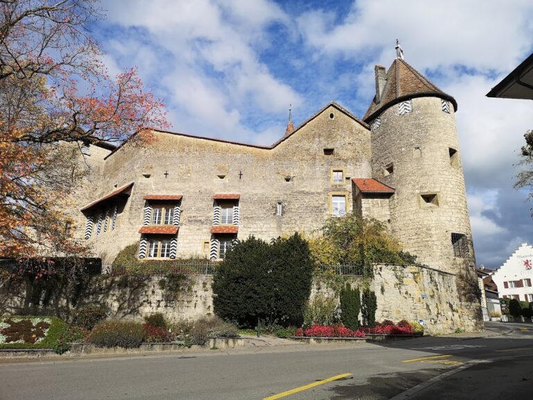
The medieval tower containing the Roman Museum was built in the 11th century over the amphitheatre, particularly above its eastern entrance. The museum displays a copy of the gold bust associated with the Cigognier sanctuary and preserves the gilded bronze roof ornament from the Temple of the Grange des Dîmes.
Other displays include wall paintings, mosaics, inscriptions, funerary stelae, and sculptural elements from two funerary monuments more than 20 metres high. These monuments were discovered east of the ancient city at En Chaplix. Together with Aventicum’s ceramic graffiti, the finds provide evidence for the city’s religious life, commemorative practices, personal names, everyday messages, and material culture.