El Camp de les Lloses: An Iberian and Romanizing Archaeological Site in Spain
Site at a Glance
- Rating
- 4.4
- Popularity
- Low
- Country
- Spain
- Primary era
- Classical
- External website
- Open
- Eras represented
- Classical
- Civilizations
- Iberian, Roman
- Site type
- Domestic
- Remains
- House
On this page10 sections
History
El Camp de les Lloses is an archaeological site at Tona in Spain, established during the transition from the late third to the early second century BC and occupied mainly from the second to the first century BC. Its development belonged to the Romanization of northeastern Iberia, the gradual reorganization of local political, economic, social, cultural, and ideological structures under Roman influence, while retaining strong connections with the Ausetani, the Iberian people of the Osona region.
Foundation and changing routes
The settlement was founded at the entrance to the Plana de Vic, on the watershed between the Ter and Congost rivers. Its position brought together routes from the Montseny massif, the western inland regions, the Maresme and Barcelona coastlands, the central Catalan depression, and the roads leading toward the Pyrenees. This location gave the site a strategic role as older traffic along the Ter route toward Emporion, a major ancient trading centre on the northeastern coast, declined in favour of the more direct Congost route to Tarraco, the principal city and provincial capital of Hispania Citerior.
Between approximately 120 and 110 BC, a section of the earliest known Roman road in the Iberian Peninsula was built in the area. The road served as a military penetration route from Transalpine Gaul into the central Catalan depression and probably continued through Ilergetian territory toward Celtiberia. Milestones attributed to Mani Sergi, governor of Hispania Citerior, attest its construction. One was found near the Vilar house, close to El Camp de les Lloses.
Settlement and occupation
People had inhabited the area since the Late Bronze Age. A possible earlier level exposed after heavy rains in 1944 contained human remains buried beneath stone slabs and has been dated approximately to the sixth or seventh centuries BC. Its interpretation as a separate occupation level remains tentative, while the settlement’s most important phase began in the second century BC.
El Camp de les Lloses was more than a rural settlement. Its inhabitants combined primary economic activities with metal production and exchange or market functions. The material found there reflects contact between the Ausetani and Romanizing influences, together with commercial links between inland and coastal territories.
Buildings A and B were occupied approximately between 120 and 80 BC. Coins allow a latest possible beginning in the last third of the second century BC, while imported ceramics place their principal period toward the end of that century. Their abandonment appears to have been sudden. Occupation continued in Building C, used approximately from 40 BC to AD 25, with its final phase belonging to the first quarter of the first century AD.
Excavation and heritage protection
The Iberian stele of Tona was found accidentally in 1915 and is now kept at the Episcopal Museum of Vic. Heavy rains in 1944 exposed settlement structures and led to the first excavations, carried out between 1960 and 1972. Numerous structures were identified across the area in the early 1990s, followed by regular excavation and musealization until 2006.
El Camp de les Lloses was declared a Cultural Heritage Site of National Interest in 1995, Catalonia’s high-level legal category for protected cultural heritage, including important archaeological sites. It received national historic, artistic, and archaeological monument status in 2013. The interpretation centre opened in July 2006 as part of the long-term archaeological and musealization project and presents material from the settlement alongside information about the lives of its inhabitants.
Remains
The site occupies a level area within the urban zone of Tona, at the foot of the Castle hill. Its settlement plan is arranged as a grid around two perpendicular axes running north to south and east to west. Much of the archaeological area now lies beneath houses, including buildings erected directly over the remains. The Roquet apartment buildings and the former rectory mark the northern edge. The rectory was built in 1577 and burned in 1936.
Domestic and communal buildings
Buildings A and B
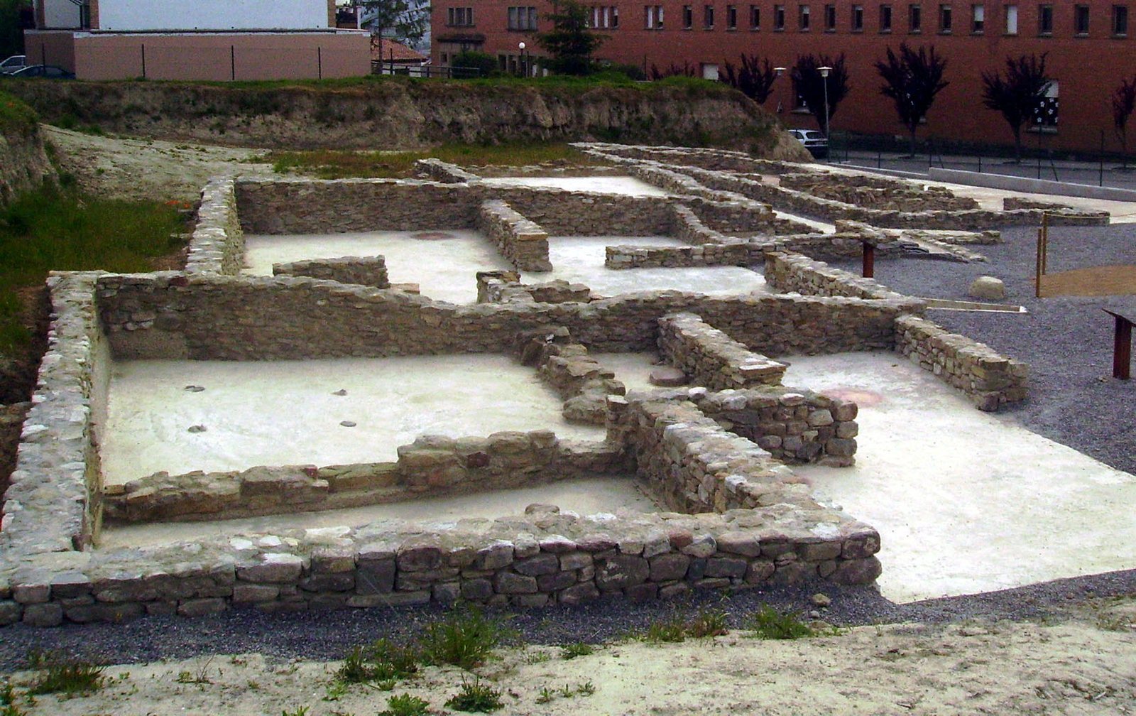
The excavated sector near Germana Victòria Street contains adjoining spaces with domestic and specialized functions. One complex covers approximately 100 square metres and is divided into four internal areas. Building A contains several rooms used for household and artisanal activities, with additional wall structures attached to its eastern and western sides. A large rectangular area lay west of the building, while an open communal space or courtyard was situated to its north.
Building B stands east of Building A and is almost symmetrical to it, with similar dimensions and internal divisions. Both the building and its rooms are rectangular. Its spaces supported storage, hearth use, spinning, and grinding, and the finds also point to activities connected with beliefs and religious rituals.
Building C
Building C stands opposite Area 19 of Building A and belongs to a later phase. Its walls follow the same north-south and east-west organization, although the structures are displaced slightly toward the northwest and southeast. The building contains four rectangular rooms, larger than those in Buildings A and B. Its roof was probably covered with tegulae, flat Roman roof tiles usually used with curved covering tiles. Hearths, cooking, spinning, storage, and metalworking took place in its rooms.
Construction and metalworking
The lower parts of the walls were built from irregular stones laid without mortar. Above a height of approximately 120 to 130 centimetres, the walls consisted of thick adobe made from earth mixed with small stones and plant fibres. Wooden beams probably supported the roofs, which were covered with straw in the earlier buildings.
A metalworking workshop is identified by combustion structures, metal slag and waste, mould fragments, crucibles, and numerous iron and bronze objects. A channel in the workshop was probably associated with casting. The workshop produced bronze accessories and decorative fittings, recycled worn or broken bronze objects, and made iron tools and household equipment. Small copper-alloy items, including nails and fittings, were manufactured by recycling disused ornamental bronze objects of Italian origin.
Road and excavated finds
The Roman road associated with the settlement survives as covered remains in a nearby road leading toward Collsuspina. The milestone bearing the name of Mani Sergi was found near the Vilar house and connects the local route with the wider military road system of the period.
Coins from the site include substantial numbers of Iberian asses and fractional coins, smaller denominations used for lower-value transactions. Their varied origins indicate links between inland and coastal communities. Other finds include bronze ornaments, feet from lampstands, fragments of a statue or larger bronze object, numerous iron objects, and grey, fine, painted, common, imported, and locally made ceramics.
The ceramic assemblage includes fine tableware, ordinary vessels, amphorae, large containers used to transport food and liquids, and imported fine wares. Both amphorae and other vessels were brought from elsewhere and produced locally. Together, these materials illuminate the settlement’s commercial connections and help establish the chronology of its occupation.