Varnenum Temple, Aachen: A Gallo-Roman Temple Precinct and Vicus

Site at a Glance
- Rating
- 4.4
- Popularity
- Low
- Country
- Germany
- Primary era
- Classical
- Eras represented
- Classical
- Civilizations
- Roman
- Site type
- Religious
- Remains
- Temple
On this page18 sections
History
Varnenum Temple is a preserved and partly restored Gallo-Roman temple precinct and associated settlement in Germany, at Kornelimünster within the city of Aachen. Founded before the beginning of the Common Era, it developed through several building phases and remained in use from the first century until the middle of the third century. Its inscriptions identify the local Celtic deities Varnenus and Sunuxsal, placing the site within a religious landscape that combined Roman architectural forms with regional traditions.
Foundation and first construction phases
The earliest phase, known as Period I, consisted only of Building H, an undated structure whose function is uncertain. It predates the adjacent Temple G and forms the earliest identified stage of activity at the precinct.
Period II brought a more extensive complex. It included Buildings B, D, E, F1, G, R1, and R2, with temples, accommodation or administrative structures, and facilities interpreted as storage buildings. Part of this complex was destroyed by fire around AD 70, an event that ended the period and led to substantial rebuilding.
Period III involved the reconstruction and expansion of the sanctuary. A sestertius, a Roman coin, minted under the emperor Vespasian dates this phase to his reign from AD 69 to 79. Buildings C, F2, and L belonged to this later arrangement. By no later than Period III, a vicus, or settlement associated with the Roman administrative, military, or economic landscape, had grown beside the temple precinct. Much of that settlement remains archaeologically unexplored.
The sanctuary and its religious associations
The name Varnenum is an archaeological attribution rather than an epigraphically proven ancient name. It was assigned because inscriptions found at the site mention Varnenus. Three bronze votive plaques identify Varnenus and Sunuxsal as the deities worshipped there. Sunuxsal was the tribal goddess of the Sunici, a regional community in the Roman northwest.
One plaque was dedicated to the genius of Varnenus, a divine spirit associated with the sanctuary or deity. Another records Marcus Fucissius Secundus, a member of the imperial six-man college of the Colonia Claudia Ara Agrippinensium, fulfilling a vow to Varnenus. A third names Luo, son of Cisso, who fulfilled a vow to Sunuxsal. The dedications show that worship at the site involved both local religious identities and people connected with Roman civic institutions.
A fourth inscription may have been the sanctuary’s building inscription. Found reused in 1972 during excavations at the Stephanskirche, its stone may state that Perpetuus financed the construction from his own resources. The inscription is now kept at the LVR-Landesmuseum Bonn. Two of the bronze plaques were lost during the Second World War, another is held in the depot of the Suermondt-Ludwig-Museum in Aachen, and casts of the inscriptions are preserved at the LVR-Landesmuseum Bonn.
Later development and changing significance
During the later, not precisely datable Period IV, a temenos, meaning an enclosed sacred precinct, was formed around the southern part of the complex. It had a gateway, but no other buildings from this period are known. The sanctuary and settlement continued in use until the middle of the third century.
Aerial photography and magnetometer surveys indicate a direct route connecting Varnenum with Breinig, where calamine was mined in antiquity. The later growth of Aachen and the importance of its baths have led to the interpretation that some of Varnenum’s cultural significance may eventually have passed to a Sunuci sanctuary established between Aachen Cathedral and the Büchel baths.
Excavation and preservation
The first documented excavations took place in 1907, 1911, 1923, and 1924. Further work in 1986 and 1987 followed magnetometer surveys by the Rhineland archaeological heritage service and phosphate analysis by Kiel University across about 250,000 square metres. These investigations helped place the excavated buildings within a much larger settlement landscape.
Between 2016 and 2018, the Archaeological Institute of the University of Cologne used geomagnetic survey, geoelectric methods, and ground-penetrating radar. The investigations located additional buried remains and indicated that the settlement was more extensive than previously assumed, broadly confirming the earlier phosphate analyses.
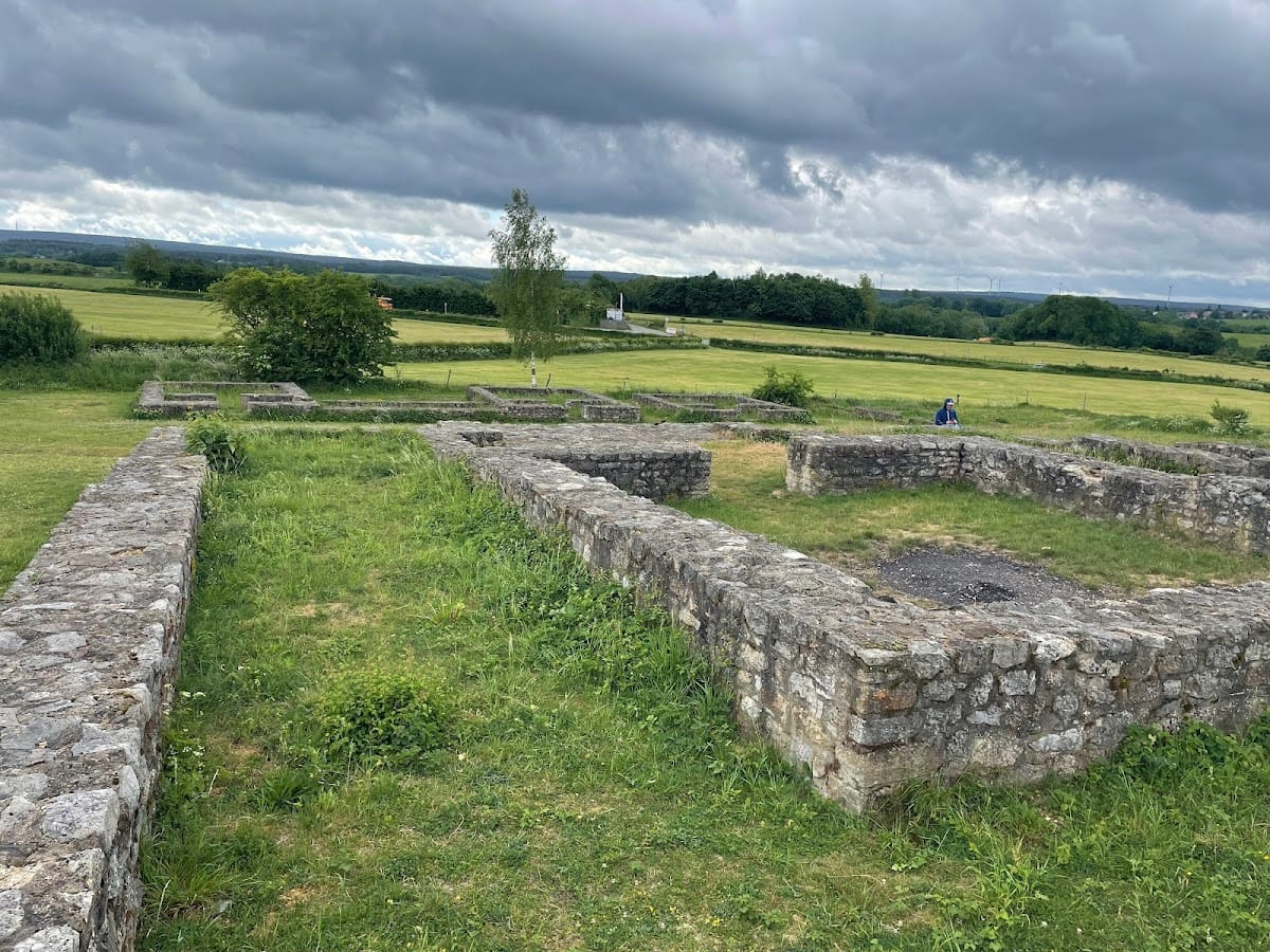
The excavated temple remains and foundations of several ancillary buildings were restored in 1989 and rebuilt to approximately one metre high. Varnenum is owned by the City of Aachen and maintained by the Eifelverein Kornelimünster. The vicus and temple precinct are registered archaeological monuments under North Rhine-Westphalia’s monument-protection law and appear in Aachen’s archaeological-monument register.
Remains
The temple precinct covered at least 150,000 square metres according to geophysical and phosphate investigations. Its temples occupied one part of the complex, while an open area at least 100 by 55 metres extended between them and the southern line of buildings. This space probably accommodated processions and other outdoor cult practices. The remains combine several Gallo-Roman temple plans with buildings interpreted as residences, storage facilities, halls, and possible official spaces.
Temples and sacred buildings
Temple F
Temple F preserves two construction phases. The earlier F1 consisted of a cella, or central chamber, measuring 8.87 by 6.94 metres, surrounded by a covered ambulatory, a passage around the chamber. The whole building measured 14.60 by 13.30 metres, or about 194 square metres. Its open staircase was 7.30 metres wide and 4.10 metres deep. The later F2 retained the cella-and-ambulatory arrangement but enlarged the temple to 19.00 by 17.20 metres, or about 327 square metres. Its cella measured 9.20 by 8.70 metres, and its staircase was 7.30 metres wide and 2.90 metres deep. F2 has been reconstructed and is visible above ground, while F1 lies beneath it.
Temple G
Temple G stood west of Temple F and measured 14.60 by 13.55 metres overall, or approximately 198 square metres. Its cella measured 8.10 by 6.80 metres. The building was an anta temple, a form with projecting side walls that frame the front porch, or pronaos. Its southern open staircase measured 7.30 by 2.90 metres. Almost the entire ground plan survives, apart from the west wall, and remains visible in the terrain.
Building C
Building C belonged to Period III and overlay the earlier Building E. It had two wings, designated C1 and C2, with a portico along the front. A paved courtyard opened behind the portico between the wings. The structure measured up to 20.30 by 9.10 metres, or about 185 square metres, and may have served as a priest’s residence or as an official building where votive offerings were displayed. Its foundations have been restored and reconstructed.
Southern buildings and enclosure
Buildings B, D, and E
Building B formed part of the southern line of Period II structures. It was a two-room building measuring 19.0 by 9.1 metres, or approximately 173 square metres, and is interpreted as a magazine or storage facility. Its eastern wing remains visible. Immediately east stood Building D, which measured 8.00 by 6.22 metres, or about 50 square metres. It may have been a priest’s residence, although its arrangement also allows an interpretation as an official building or as a structure formed through two construction phases. Its central section survives on the site.
Building E was another structure interpreted as a priest’s residence. It measured 13.80 by 5.90 metres, or approximately 81 square metres, and was later overlain by Buildings C and L. Building L itself was also interpreted as a priest’s residence and occupied the position of the earlier building.
Buildings R1 and R2
Buildings R1 and R2 may have served as residences or guest accommodations. R1 measured 11.78 by 6.40 metres, or about 75 square metres, while R2 measured at least 9.00 by 6.04 metres, or approximately 54 square metres. Their placement among the Period II buildings contributes to the evidence for residential and service activity around the sanctuary.
Temenos wall
The Period IV temenos wall enclosed the southern portion of the precinct. Its gateway was 3.08 metres wide. The wall and entrance are overgrown, but their traces remain faintly visible.
Vicus and associated buildings
Buildings A, K, and M
Building A stood in the western part of the settlement and measured 12.35 by 6.55 metres, or approximately 81 square metres. It is interpreted as a magazine or warehouse. In the northern area, Building K formed a multi-part structure of uncertain function with maximum dimensions of 26.40 by 16.00 metres, or about 422 square metres. Nearby Building M was divided into sections M1 and M2 and measured at least 18.35 by 6.60 metres, or approximately 121 square metres.
Building P and the eastern road
Building P was a colonnaded hall with an internally paved surface. It measured 25.00 by 6.85 metres, or approximately 171 square metres, and overlapped the Period II Building R. Geophysical surveys conducted from 2016 to 2018 also detected an east-west road that had not previously been recorded. Four strip houses were identified along its southern side, with an orientation corresponding to that of the previously known remains.
Inscriptions and recovered objects
The three bronze votive plaques were tabulae ansatae, dedicatory tablets with handle-like projections. Their inscriptions invoke the genius of Varnenus, the god Varnenus, and the goddess Sunuxsal. Alongside these plaques, excavations produced brooches, pins, nails, coins, and pottery. These finds were lost during the Second World War, while the surviving inscriptional evidence continues to identify the religious communities connected with the precinct.