Ensérune: An Iron Age Hill Settlement and Archaeological Museum in France


Site at a Glance
- Rating
- 4.3
- Popularity
- Low
- Country
- France
- Primary era
- Iron Age
- External website
- Open
- Eras represented
- Iron Age, Classical
- Civilizations
- Celtic, Iberian, Roman
- Site type
- City
On this page19 sections
History
Site and archaeological museum Ensérune is an ancient hill settlement and archaeological museum in France, near Nissan-lez-enserune. Built and developed by communities of Mediterranean Gaul, the settlement was founded around 575 BC and occupied from the early or middle sixth century BC until the first century AD. Known as an oppidum, a fortified or naturally defensible Iron Age hill settlement, Ensérune became one of the principal communities of Mediterranean Gaul and formed part of the Iberian-Languedoc cultural sphere.
Foundation and Mediterranean connections
Ancient authors associated Ensérune successively with the Elysiques, an Iron Age people linked with western Languedoc, and the Volcae Tectosages, a Celtic people whose territory later included parts of southern Gaul. The settlement stood where maritime and overland routes met. From around 600 BC, Greek ports such as Massalia, Agathe, Emporion, and Rhode intensified exchange across the western Mediterranean. The Via Domitia, the Roman road linking Italy with the Iberian Peninsula through southern Gaul, was built at the foot of the hill between 120 and 115 BC.
Greek commercial influence remained strong for almost five centuries. Large quantities of luxury black-glazed tableware, including Greek cups and kraters, reflect these connections. Between approximately 450 and 200 BC, links with Iberian coastal trading centres brought weapons, ceramics, jewellery, votive objects, wine, and olive oil to Ensérune. These imports entered a settlement that retained its own languages, customs, and systems of production.
Three phases of occupation
Ensérune I consisted of dispersed and modest dwellings dating from the sixth and fifth centuries BC. Its inhabitants were farmers, herders, hunters, and fishers. They stored food in cavities cut into the rock and used simple stone tools with limited metal equipment. The settlement’s economy also relied on exchange with Mediterranean and regional communities.
During Ensérune II, from the late fifth to the late third century BC, the hill developed into a more structured commercial settlement. Its market brought together agricultural and craft products, metal weapons and jewellery, Catalan and Languedoc ceramics, Massaliot amphorae, and Greek vases. Collective grain storage became increasingly important as large ceramic dolia, thick-walled vessels used for grain, wine, or oil, supplemented or replaced some earlier underground silos. More than 500 cremation burials belonged to the cemetery associated with this phase. Early burials placed ashes in pits with fragments of burned vessels, while later graves used urns and, during the cemetery’s third phase, central urns surrounded by food offerings. Weapons and jewellery were particularly associated with adult male burials, and grave furnishings varied according to age and social status.
Ensérune III extended from the late third century BC to the late first century BC or the first century AD. The settlement expanded westward and across the southern slope, including ground previously occupied by the cemetery. Its inhabitants adopted architectural and material influences from Greek and Roman traditions while maintaining indigenous practices. Streets were paved and drained, houses became larger and more elaborate, and some residences were arranged around open atria with columns, wall paintings, and mosaic floors.
Romanization and abandonment
Roman influence grew through expanding wine commerce, the creation of Gallia Narbonensis, the Roman province established in southern Gaul, and the adoption of Latin and Roman systems of measurement. The local pantheon also became more diverse, while large urban residences appeared. Indigenous coins bearing Greek or Iberian inscriptions show that older traditions continued alongside Romanization.
Ensérune was gradually abandoned during the first century AD. Its inhabitants moved to villas in the lowlands, which suited the economic system imposed by the Roman Empire. Sediment and vegetation later covered the ruins. The ancient name of the settlement remains unknown, although medieval and later forms of the place-name are recorded from the ninth century onward. The site is not mentioned in surviving Latin texts.
Discovery, excavation, and museum development
Iberian coins found by numismatists around 1850 drew attention to the hill. Between 1843 and 1860, Abbé A. Ginieis, parish priest of Montady, explored the area and identified walls, silos, an incineration cemetery, and other buildings. Félix Mouret began systematic excavation in 1915 after acquiring land at the western end of the hill. By 1922 he had excavated 300 graves, and he published a catalogue of ancient vases in 1928. That year he transferred his vineyard to the state on the condition that the entire property receive heritage protection.
Official scientific excavations began in 1928 under Abbé Louis Sigal, whose use of stratigraphic methods and detailed surveys, sections, plans, photographs, and field notes established a lasting research record. His work helped secure Ensérune’s recognition as an excavation site of national importance in 1936. In 1937, Jules Formigé was commissioned to create a museum at the excavation site. He renovated and enlarged a villa built in 1914 at the highest point of the plateau, where ancient structural remains were also found in the basement.
Jean Jannoray assumed responsibility for the cultural-historical antiquities department in 1945 and continued work at Ensérune with Abbé Joseph Giry. His 1955 study placed the settlement within the wider history of the pre-Roman civilizations of southern Gaul. Hubert Gallet de Santerre succeeded him in 1958 and opened the site to teaching excavations. From 1980, Martine Schwaller and her team investigated previously untouched graves, producing a more reliable chronology and new interpretations of the site and its collections. C. Dubosse supplemented the catalogue of Attic ceramics in 1998, while later campaigns by Gallet de Santerre, Schwaller, Cécile Dubosse, and M.-E. Bellet examined the summit and an artisans’ area. Restoration campaigns in 1988, 2001–2002, and 2006 followed archaeological investigation and improved the protection of the remains.
The archaeological site and museum are administered by the Centre des monuments nationaux. French historic-monuments legislation protects Ensérune through classifications made in 1935 and 1936, and the site belongs to the Iron Age Europe network, an international partnership for research, preservation, and presentation. The museum’s excavation material includes ceramics, weapons, grave goods, coins, tools, and other finds. The ground-floor Sigal Hall presents daily life and trade from the sixth century BC to the first century AD, the Mouret Hall displays Attic vases, and the Jannoray Hall presents complete grave assemblages, including Grave 163.
Remains
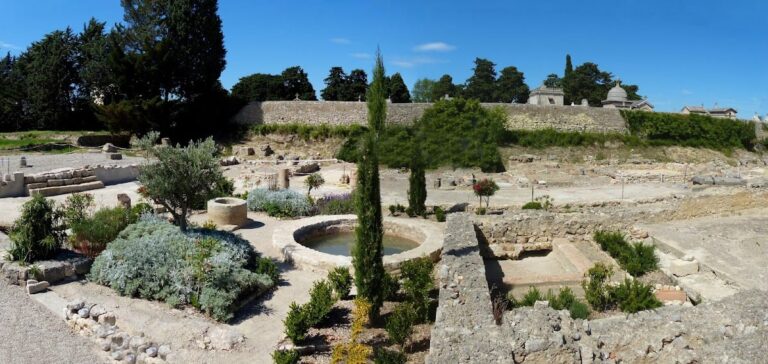
Ensérune occupies a steep rocky plateau aligned from east to west. It is approximately 650 to 750 metres long, about 120 metres above the surrounding plain, and up to roughly 250 metres wide. The soft Miocene rock, formed from littoral marine sands, could be cut for silos, terraces, cisterns, and other installations. The elevated position overlooks the coastal plain, the Montady basin, the Canal du Midi, and the Béziers and Narbonne regions, with views described as extending toward the Pyrenees. Terraces, vineyards, and olive groves occupy the southern slopes, while the western ridge descends towards the plateau of Poilhes.
Settlement and neighbourhoods
The earliest houses of Ensérune I were simple rectangular structures placed irregularly across the plateau. Their floors were cut into bedrock and covered with beaten earth, with a hearth set in a shallow depression. Walls used wood-reinforced wattle coated with straw-tempered earth, and roofs consisted of branches sealed with clay. Most houses contained a rock-cut silo. Roughly formed pottery and mainly stone tools belonged to this early domestic setting.
Ensérune II introduced rectangular stone houses, usually single-room buildings arranged in neighbourhoods along roads. Their placement followed the contours of the hill rather than a confirmed regular grid, and a central wooden post generally supported each roof. The settlement occupied the highest terraces and parts of the southern slope, where substantial retaining walls created level ground. In the northern quarter, long rows of one-room houses extended for more than 250 metres beside a road. Many houses held a silo or dolium, while larger buildings contained two or three storage vessels. Some were constructed over earlier storage installations.
Several buildings preserve evidence of changing construction. One house has a reconstructed column on a square base, with a circular tapering shaft and bracket-like capital that apparently supported the roof ridge. Another contains a cistern with two surviving supports for its former roof. Roads were repeatedly raised from the sixth century BC onward, and the layers of one northern road preserve a sequence reaching back to that period.
During Ensérune III, streets were paved and equipped with drainage channels. Houses retained elements of earlier one-room plans but became larger and more complex under Greek and Roman influence. In the western quarter, buildings were arranged around open atria with columned porticoes, painted walls, and mosaic floors. Some columns followed Doric or Ionic forms, while limestone columns replaced earlier wooden roof posts in at least some houses.
Western and southern quarters
Western residences and public buildings
The largest western-quarter house covered approximately 500 square metres. Built in the second half of the first century BC and used until the end of that century, it contained about ten rooms grouped around a central atrium. Another residence included a room of approximately 25 square metres with painted surfaces and a mosaic floor. Its arrangement may identify it as a dining room, or triclinium, a Roman-style dining room furnished with three couches around a central space.
A rectangular western-quarter building measured about 82 square metres and was divided by a central colonnade. Its walls stood on sun-dried-brick foundations, and its probable pitched roof used flat tegulae and curved imbrices, the two standard types of Roman roof tile. Its purpose remains uncertain, with an assembly hall or covered market among the possible interpretations. A second large rectangular building in the southern part of the western quarter also measured approximately 82 square metres and was divided internally by five columns. It has been interpreted as a market hall.
Southern slope
The southern slope contains a large rectangular cistern with waterproofed walls, an east–west road, one-room houses, and silos, including one that collapsed. Wall paintings were found in one house. A restored section of the southern quarter includes a retaining wall about three metres high on its downslope side. A drain made from flat tiles passes through the wall, which was once interpreted as part of a fortification and has been rebuilt. The adjacent road is paved with small rubble stones.
In the western part of the southern quarter, a large room stood beside five adjoining dolia. The area also includes a silo formerly used as a cistern and traces cut into the bedrock from an Ensérune I dwelling. These surviving features show how later construction incorporated and altered earlier installations.
Defences and terraces
The defensive system remains under discussion. Earlier interpretations proposed a fortification more than 2.5 kilometres long, begun during Ensérune II and extended westward during Ensérune III, with a double vallum, an earthwork or ditch-and-bank defence, west of the settlement. Excavated walls on the northern and southern sides were in places equipped with parapets and included at least three entrances or posterns, small openings through a fortification. No towers have been identified.
Some walls that appear defensive also served as terrace supports. A continuous fortification has not been demonstrated along the populated southern side, and a wall excavated in 1996 belongs to a land enclosure, although its associated ditches have not been securely identified as defensive works. Current interpretations emphasize retaining walls approximately 4.5 metres high, built to create level ground for construction and possibly to offer protection.
The northern terrace, once interpreted as a defensive terrace, is about 15 metres wide and supported by a wall. A well-preserved postern, 1.6 metres wide, crosses a wastewater outlet from the road. A western stairway led down towards the spring below the hill.
Storage and water management
Silo Terrace
The Silo Terrace was discovered during road and car-park construction in 1966. Excavations in 1966 and 1967 exposed storage cavities cut into yellow tuff, generally between one and three metres deep. Most had bottle-shaped bodies, narrowed necks, and flat or rounded bases. Some collapsed because they were placed too close together, while others were cut through when the terrace was levelled.
More than 300 silos are known on the hill and its surroundings. Their profiles were ovoid, bottle-shaped, bell-shaped, or cylindrical, with narrow necks and stated capacities of approximately 10,000 to 85,000 litres. The interiors could be coated with clay and fired or carbonized to limit fermentation, allowing grain to remain in storage from autumn to spring. Silos were used mainly for dry grain and seed, either individually within houses or collectively in areas such as the eastern Silo Terrace and the southwestern Château de l’eau.
Château de l’eau
The Château de l’eau, or “Water Tower,” is a named area and building whose surviving installations were mostly used for storage rather than forming a coherent water system. Around 40 silos lie in the area, some approximately five metres deep. Several overlap, showing successive construction, while three are linked by tunnel-like openings and others share channels or drainage systems. Most are interpreted as dry grain stores. Large dolia, introduced at Ensérune from the late third century BC, were sunk into floors and used chiefly for grain, but also for oil and wine.
The Château de l’eau building stands on a rock-cut terrace beside a level area containing numerous silos. Two perpendicular walls of mortarless masonry survive. The undated building was at least 22 metres long, with a façade about 10 metres wide, and used blocks approximately 1.00 to 2.25 metres long and 50 to 60 centimetres high. Its function is unknown, and it remains uncertain whether its plan was simply rectangular or included a portico.
Roads, cisterns, and basins
South of the Château de l’eau, a 50-metre stretch of road has been exposed. The roadway is approximately three to five metres wide and retains wheel ruts. A stone-covered drain carried runoff from houses along the road. Water supply required substantial engineering because only one spring, the Agoutis spring at the foot of the northern slope, is securely identified. Rainwater was collected from roofs and carried through channels into cisterns.
Ten public or private cisterns cut into rock or built in masonry have been identified. Their capacities range from approximately 18 to 77 cubic metres, and their interiors were waterproofed. Ensérune III cisterns were often large, elongated, and covered. Seven additional rectangular basins range from approximately 0.75 to 2.60 cubic metres. Built with masonry and mortar joints, they were lined with waterproof plaster containing brick powder. Their precise functions remain uncertain, although they may have held foodstuffs other than those stored in silos and dolia.
Cemetery and artisans’ quarter
Cremation cemetery
The Ensérune II cemetery lay outside the western end of the settlement and contained more than 500 cremation graves. The area was later built over during the settlement’s expansion, leaving only a small number of remains in situ. Grave 163, dating to the first quarter of the third century BC, contained an exceptionally rich assemblage. A black-glazed krater from Rosas served as an ossuary alongside large bowls, a small black-glazed vessel, an Attic fish plate, handmade vases, and a balsamarium. Weapons included a sword with a ribbed blade and diamond-shaped tang, a sheath with lyre-shaped coral inlays, a decorated spearhead, a shield boss, and a narrow shield rim. A bronze belt chain and four fibula fragments completed the assemblage.
Weapons occur in approximately 30 percent of the excavated graves. The collections include swords, spears, shield fittings, and other military equipment, often decorated in distinctive Celtic styles. The cemetery and settlement also produced Attic, Campanian, Aretine, Catalan, Iberian, Massaliot, and southern Gallic ceramics, including black- and red-figure vessels, Terra Sigillata, amphorae, kraters, cups, plates, and other tableware. Some vessels show mythological figures, daily activities, animals, and objects.
Artisans’ quarter
The artisans’ quarter was restored in 2001–2002. Reused horizontal columns came from a press, and a fullery lay farther south. Excavation revealed a large elongated rectangular cistern and stamp impressions whose originals are presented in the museum. A finely built wall stands before an unbuilt area. It was underpinned during Ensérune III but originated in an earlier phase. Its function is unknown, although its workmanship may have been decorative and has been compared with Iberian construction.
Museum and archaeological collections
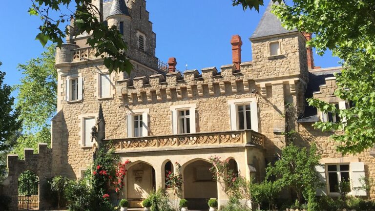
The museum occupies the renovated and enlarged villa built at the highest point of the plateau in 1914. Ancient building remains discovered in its basement connect the modern exhibition space with the earlier settlement. Ensérune has yielded more than 1,000 graffiti in the Iberian alphabet on pottery, forming a major body of evidence for a language that remains uncertain. The collections also contain Attic black- and red-figure vases, grave goods, weapons, ceramics, coins, tools, and other objects from the settlement and cemetery.
Attic black-figure pottery uses dark figures painted on a lighter clay surface, with details added by incision and colour. In red-figure pottery, the figures retain the colour of the clay against a dark background, with details painted by brush. Together with imported amphorae, kraters, plates, and cups, these vessels illustrate the range of Mediterranean connections represented in the archaeological remains.