Area Archeologica di Solunto: The Remains of a Hellenistic-Roman City in Italy

Site at a Glance
- Rating
- 4.3
- Popularity
- Low
- Country
- Italy
- Primary era
- Classical
- External website
- Open
- Eras represented
- Iron Age, Classical
- Civilizations
- Ancient Greek, Carthaginian, Phoenician, Roman
- Site type
- City
On this page27 sections
History
The Area Archeologica di Solunto in Italy preserves the remains of Solunto, a settlement shaped by Phoenician, Greek, Punic, and Roman traditions. Its first foundation is traditionally placed in the eighth or seventh century BC, although the evidence does not confirm a Phoenician origin. The city was rebuilt on Monte Catalfano in the mid-fourth century BC after the earlier coastal settlement was destroyed or severely damaged by Dionysius I of Syracuse during his war against Carthage.
The Coastal Settlement and Its Rebuilding
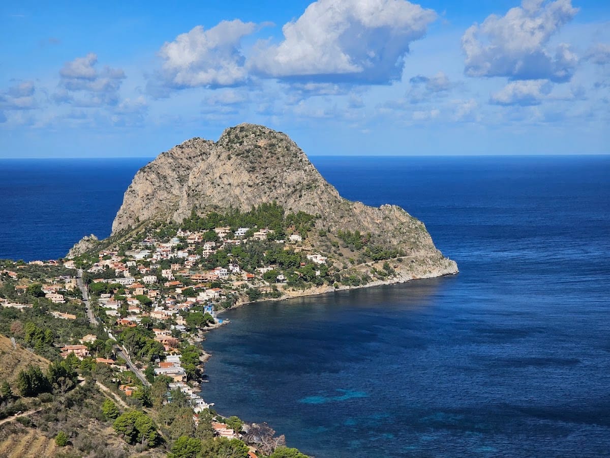
Solunto was one of the three principal Phoenician settlements in Sicily identified by Thucydides, the fifth-century-BC Greek historian, alongside Motya and Panormus. The earliest settlement occupied the Solanto promontory and the adjoining San Cristoforo plateau, although its exact position remains uncertain. Punic remains at Capo Solanto are now considered likely evidence for the archaic city. A Sicani foundation has also been proposed, and the archaeological evidence is insufficient to settle the question of the settlement’s earliest identity.
The settlement had both Greek and Punic names. The Punic form meant “village,” reflecting the city’s connection with the wider Punic world. Around 396 BC, Dionysius I, the tyrant of Syracuse who led major conflicts with Carthage, destroyed or seriously damaged the coastal settlement. Solunto was then established again on Monte Catalfano, where the surviving urban area developed across the southeastern slope.
In 307 BC, Carthage settled Greek soldiers and mercenaries who had been abandoned in Africa after the failed expedition of Agathocles. Their presence at Solunto is reflected in Greek inscriptions, architecture, magistracies, and priesthoods. The city therefore retained a strong Greek institutional and cultural character while preserving Punic religious practices and building traditions.
Hellenistic and Roman Solunto
Solunto came under Roman control during the First Punic War, in the mid-third century BC. It flourished particularly during the third and second centuries BC, when extensive construction gave it the institutions and buildings of a Hellenistic-Roman city. Its own coinage, issued from the fifth century BC into the Roman period, included silver didrachms and obols as well as bronze denominations. The coins carried Punic and Greek legends and showed figures or symbols including Heracles, the hippocamp, Poseidon, Athena, and possibly Ares. Soluntine coins found at settlements elsewhere in Sicily indicate the community’s economic importance.
During the first century BC, Solunto remained inhabited by wealthy citizens despite the practical difficulties of supplying a settlement on a steep mountain slope. Cicero described it as a civitas, a recognized civic community, and included it among the tax-paying communities of Sicily during the governorship of Gaius Verres from 73 to 71 BC. Its urban fabric combined Greek planning and public institutions with Punic elements in religion, burial customs, domestic shrines, masonry, cisterns, and floors.
Construction largely ceased during the first century AD, apart from renovations and possible new baths. The city was gradually abandoned, probably as changing social and economic conditions affected late Imperial Sicily. An earthquake or landslide may also have contributed to its decline. A civic dedication to Fulvia Plautilla, the wife of the emperor Caracalla, dated approximately 202–205 AD, provides the latest firm chronological evidence for the city.
Excavation and Preservation
Tommaso Fazello identified the site from ancient literary evidence in 1558. Excavations began in 1825 under Domenico Lo Faso Pietrasanta, who uncovered a sanctuary and several statues. Francesco Saverio Cavallari began systematic work in 1856, and the first city plan was published in 1875. Antonino Salinas continued the investigations.
Ettore Gábrici undertook further excavations in 1920, followed by Vincenzo Tusa from 1951. Tusa uncovered the House of Leda in 1953, the theatre in 1963, and the House of Harpocrates around 1970. Investigations by the German Archaeological Institute began in 1964, while later studies examined the theatre, agora, houses, and gymnasium. Since 2009, the excavated settlement has formed part of the Archaeological Park of Himera, Solunto and Iato. Approximately half of the ancient urban area has been excavated. Coins and other recovered objects are divided between the Antonino Salinas Regional Archaeological Museum in Palermo and the museum at the site.
Remains
Urban Layout and Defences
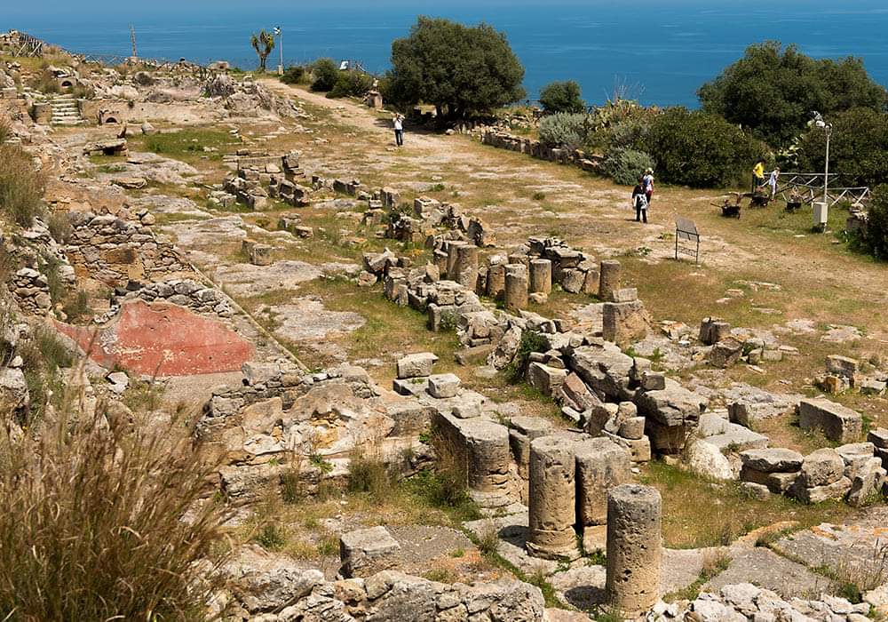
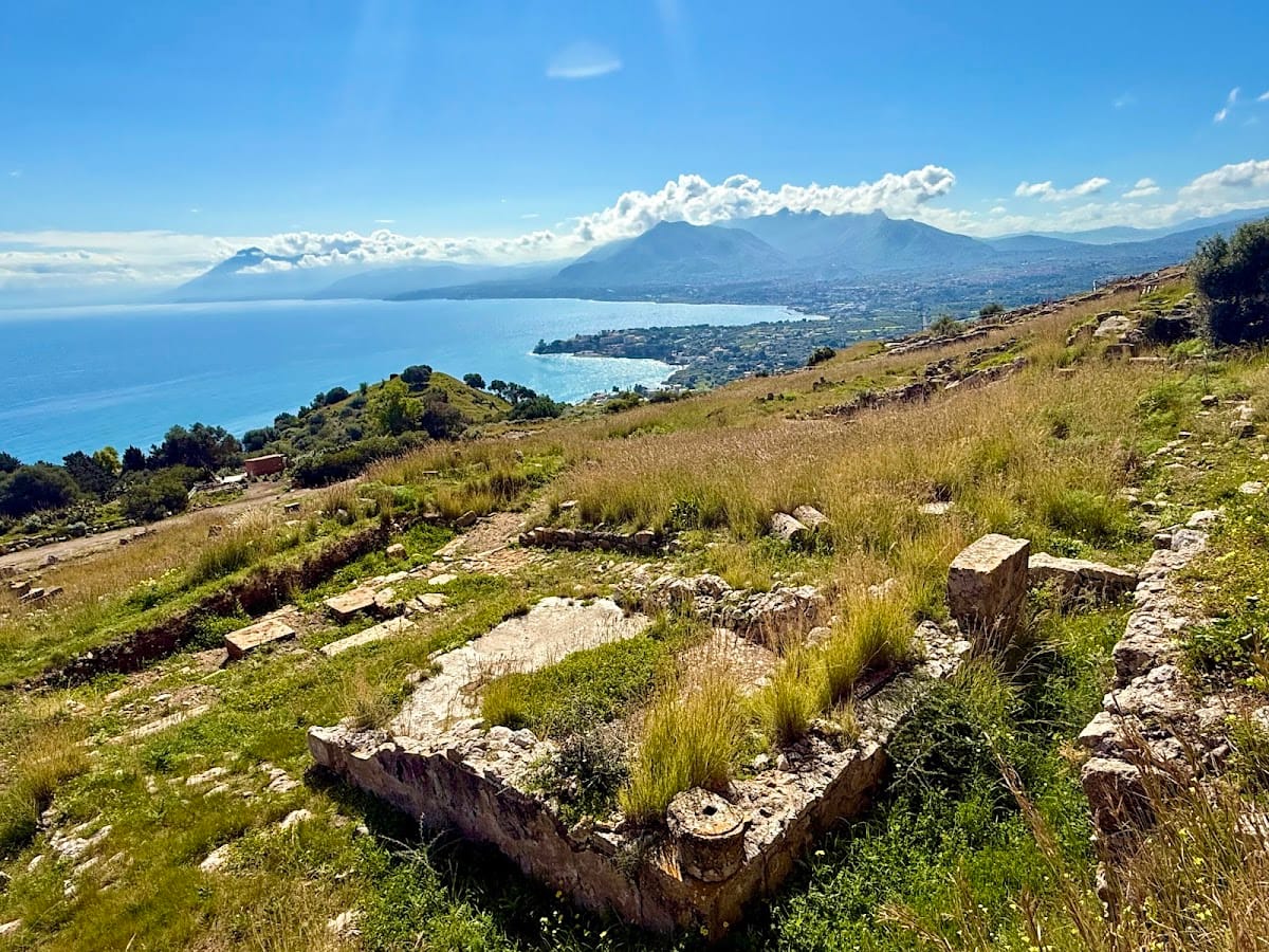
The excavated city occupies descending terraces on the southeastern slope of Monte Catalfano, overlooking the area near Capo Zafferano. Its highest and lowest points differ by about 60 metres, and the ancient urban area covered approximately 10 hectares. The settlement follows a regular Hippodamian grid, a system of streets crossing at near-right angles to create rectangular blocks, although the plan was imposed on uneven ground.
Three principal north-south streets were crossed by about eight east-west streets. Many of the cross streets became stairways on the slope. The blocks were generally rectangular, about 40 by 80 metres, and narrow drainage alleys, roughly 0.8 to 1 metre wide, divided them longitudinally. The date of this reorganization is uncertain. An earlier house beneath the theatre does not follow the grid, and the regular plan has possibly been associated with the settlement of Agathocles’ Greek soldiers in 307 BC.
Main Streets and Water Management
The principal street, now called the Via dell’Agora, is approximately 5.6 to 8 metres wide and leads toward the public quarter. It is paved partly with limestone slabs and, from about the third block, with square bricks. Three aligned blocks at some crossings may have supported wooden footbridges during flooding. The parallel streets are known as the Via degli Artigiani and Via degli Ulivi.
Rainwater collection probably supplied much of the city. Nearly every house had a cistern, while large public cisterns stood near the agora and the artisans’ quarter. Drainage channels ran through the housing blocks and continued as underground conduits beneath the main streets. A sewer system is not documented.
Fortifications
Steep cliffs protected the southern and western sides of the settlement, so the city did not have a complete circuit wall. Walls with towers are securely attested along the east and northwest sides. Erosion or a landslide has affected the northern boundary, while fortification remains beside the southeastern access road may include a tower in an area that has not been excavated.
At the northwestern edge, a wall, a rectangular tower, and a large cistern may have formed part of a defensive installation. An ancient road beside them led toward the summit of Monte Catalfano. Excavations in the eastern part of the city uncovered an altar and other structures from which the harbour may possibly have been observed.
Agora and Civic Buildings
The agora was a rectangular public plaza used for festivals, assemblies, and markets. It was bordered on three sides by porticoes and was associated with a public cistern to the north and a bathhouse to the east. The southern entrance appears to have had a gate or threshold. A stone threshold and a large six-pointed plaster star were found near this entrance.
Western Stoa
The western side of the agora was occupied by a stoa, a long colonnaded building, with projecting wings. It measured approximately 68.7 metres in length and 20.3 metres in width. Its colonnaded front stood before nine exedrae, or recessed spaces. The surviving tufa sima blocks, which formed part of the roof edge, bear lion-head waterspouts and are stylistically dated to the second century BC. The upper storey used half-columns and blocks decorated with diamond patterns.
Two Greek inscriptions in the northernmost exedra identify statues of Apollonius and Ariston, a father and son. They also state that members of these families had served as amphipoloi, religious officials associated with Zeus Olympius. The earliest stoa probably belonged to the fourth or third century BC, while most of the surviving remains date from the second century BC.
Bouleuterion and Adjacent Enclosure
Behind the stoa stood the bouleuterion, a meeting place for the city council. It is a rectangular building with five rows of seats for approximately 100 people. The structure has also been interpreted as an odeion, a smaller building for performances or music, and may have served both civic and musical functions.
A walled area south of the building measures about 31.4 by 12.3 metres. Its purpose is uncertain, although it may have been a religious precinct. The combination of the meeting building, the plaza, the porticoes, and the adjoining enclosure formed part of Solunto’s public quarter.
Gymnasium and Cisterns
North of the agora stood a poorly preserved gymnasium with a large courtyard and columns along its western side. Two large cisterns lay beneath the floor. Another public cistern near the agora measures approximately 25 by 10 metres and has nine rows of pillars that supported its roof.
Bathhouses
A second bathhouse northeast of the agora belongs to the Imperial period and survives only at foundation level. The principal bathhouse, at the southern end of the city, consisted of four large rooms and smaller side rooms. Its arrangement included an open courtyard, a cold room, a warm room, a hot room, and a heated sweating room. The warm and hot rooms had hypocausts, underfloor heating systems used in Roman baths.
The southern bathhouse also contained an apse, a stairway, and Doric architectural elements. A coloured mosaic depicted a vase. Its geometric floor mosaic dates to the first century AD, when the building was renovated. The eastern side of the bathhouse has been lost through the collapse of the steep slope.
Theatre and Sanctuaries
Theatre
The theatre adjoined the agora and was probably built in the second century BC. Its seating was cut into the slope of Monte Catalfano and originally comprised approximately 20 to 21 rows, with room for about 1,200 spectators. Some central seating stones have been reassembled in a modern reconstruction, while most of the original seating area has disappeared.
The stage building measured approximately 21.6 by 6.6 metres. It had two storeys and projecting side structures at each end. The lower facade used doors and Doric columns, while the upper facade used Ionic columns. Two caryatids may have decorated the podium, and balustrades with diamond-patterned panels probably stood on the upper level. Two construction phases are visible in the orchestra, and the theatre probably remained in use until the city was abandoned.
The theatre was built partly over an earlier house. During the first half of the first century AD, a later private house occupied part of the seating area and an adjacent public building. This reuse reflects the weakening of Solunto’s civic institutions.
Temple Complex
A temple complex behind the bouleuterion and theatre contained five shrines arranged in pairs around a central shrine. Some had niches on their western sides for statues, and three statues were recovered. None follows a conventional Classical Greek or Roman temple plan. The complex is instead associated with Punic religious traditions.
The southernmost shrine contained an over-life-size statue of Zeus or Baal. Domenico Lo Faso Pietrasanta discovered it in 1826. The statue is 1.65 metres high, made of local tufa, and generally dated to the second half of the second century BC. It is now in the Archaeological Museum of Palermo.
The northern shrines included two cellae, enclosed sacred rooms, with benches on three sides and a courtyard. Together they covered approximately 10.4 by 8.6 metres. They may have contained a statue of Hermes and a seated goddess identified variously as Astarte, Tanit, or Artemis. Made of local limestone and heavily damaged, the goddess statue shows a seated figure flanked by two sphinxes. It is now in the Archaeological Museum of Palermo. Its date is placed around 350–250 BC, and its form follows Punic artistic models.
Sanctuary in Insula VIII
Another sanctuary stood in Insula VIII at the entrance to the agora, on the western side of the Via dell’Agora. It consisted of a large courtyard house with three rooms along the street. The southern room contained three high, pillar-shaped altars. The central room had stone benches and has been interpreted as a waiting room, while the northern room had an uncertain function.
Additional Sanctuary Complexes
A separate sanctuary complex included an eastern building measuring about 20.5 by 6.5 metres and divided into three rooms. One room contained an altar with three upright betyls, sacred stones or pillars. A sloping surface may have led from the altar to a basin for collecting sacrificial blood. The central room had a two-step bench for ceremonies, and the complex underwent alterations into the Imperial period.
The adjoining sanctuary building measured about 20.5 by 16 metres and contained nine rooms on three levels. It included courtyards, benches, altars, animal troughs, a cistern, and a refuse pit filled with votive objects, loom weights, terracotta offering tables, pottery, and numerous animal bones. This deposit belongs to the original fourth- or early third-century-BC cult phase. A second phase continued into the early Imperial centuries.
Private Houses and Craft Areas
Central districts contained large, multi-storey residences with two-storey peristyles, rich mosaics, and painted decoration. A peristyle is a courtyard surrounded by columns. Peripheral houses were smaller and generally organized around simple courtyards without peristyles. They were associated with artisan and productive activities. Shops commonly occupied the lower street level, while living rooms, stables, kitchens, and other practical spaces were distributed across the upper levels.
Buildings were constructed mainly from hard grey dolomite quarried on Monte Catalfano and chalky sandstone from nearby quarries. The stones were bonded with lime mortar. Wall construction included double-shell walls, block masonry, ladder masonry, and opus africanum, a technique using vertical stone supports with smaller stones between them. Roofs were covered with terracotta tiles, and wealthier facades used pilasters and half-columns.
House Known as the Gymnasium
The house known as the Gymnasium in Insula V was a private residence rather than a public gymnasium. It was probably built in the third century BC and remained occupied until the third century AD, undergoing several alterations. Four two-room shops opened onto the Via dell’Agora. Because of the slope, the main residential level, with its two-storey peristyle, lay above them.
The house had four lower-storey Doric columns and four reconstructed columns on the upper storey. Six peristyle columns were re-erected in the nineteenth century, together with some arbitrary additions. A Greek inscription found in the area during excavations in 1865 refers to a gymnasiarch, an official responsible for a Greek gymnasium and athletic training, but the inscription did not originally belong to the house.
House of Leda
The House of Leda in Insula VII measures approximately 26.7 by 19.5 metres and covers about 520 square metres. Excavated by Vincenzo Tusa in 1963, it had four shops along the street, a side entrance from the Via Ippodamo da Mileto, and a two-storey peristyle with Ionic columns. The peristyle stood 5.65 metres above the level of the shops.
A long cistern bordered the eastern side of the peristyle. A central basin with a geometric mosaic collected rainwater and fed it into the cistern, while the peristyle itself had a simple mosaic pavement. On the western side, a triclinium, a formal dining room, contained wall paintings of individual figures, including Leda with the swan. Their date is disputed between the late first century AD, in the Fourth Style, and the first century BC, in the Second Style. They replaced an earlier First-Style decoration.
Other rooms contained geometric mosaics and painted decoration. A room south of the peristyle had a mosaic of an armillary sphere, with its lines separated by lead strips. The design may have been imported from Alexandria. The house also yielded three small female statues, including marble and limestone figures, and a large room with stone troughs that was probably used as a stable.
House of the Masks
The House of the Masks stood at the city’s highest point and was partly excavated in 1868 and 1869. It had a central atrium, an eastern peristyle, and a veranda overlooking the city and sea. One room contained well-preserved First-Century-BC Second-Style paintings imitating coloured marble panels, with garlands and hanging theatre masks. The paintings are now in the Antonino Salinas Regional Archaeological Museum.
House of Harpocrates
The House of Harpocrates in Insula VI measures approximately 20.3–20.6 by 17.5–21.8 metres and covers about 404 square metres. Vincenzo Tusa excavated it around 1970. The house had several levels, a northern entrance from the Via Ippodamo da Mileto, a vestibule, and a two-storey peristyle. Four Doric columns stood on the lower level, with four reconstructed columns above.
An exedra opposite the entrance contained a geometric mosaic showing a circle framed by a meander. A cistern lay west of the peristyle, and a stairway on its eastern side led to the second storey. The house’s modern name comes from a bronze statue of Harpocrates, the Hellenized Egyptian child-god Horus, found there.
House of the Garlands
The House of the Garlands in Insula X lies at the northern edge of the city, north of the agora. It had a peristyle court and has partly been lost through erosion. Its wall paintings included late Augustan Second-Style candelabra with garlands and painted marble revetment. The surviving paintings are heavily weathered. Simple black-and-white mosaics remain, and a small altar bearing the Punic symbol of Tanit was found inside.
Courtyard House
The Courtyard House in Insula VII measures approximately 12–14 by 19.5 metres and covers about 250 square metres. It has a southern entrance from the Via Ippodamo da Mileto, a large entrance room, a stable with stone feeding troughs, and a small courtyard with a single Doric column. The remains of columns indicate that the house had two storeys.
Craft-Production Buildings
The northwestern sector contained smaller houses associated with craft production. Millstones were found in several buildings. In Insula XIII, a building at the highest part of the city had an open courtyard, four rooms on its western side, and an oven in one room.
Burial Grounds and Conservation
The necropoleis at the foot of Monte Catalfano contain Punic chamber tombs cut into the rock. Their entrances used stairways, and elongated burial niches were cut into the walls and floors. The graves date mainly to the fourth and third centuries BC, and Tanagra figurines were common grave goods.
The necropolis at Campofranco, north of the archaic settlement and partly incorporated into the archaeological park, contains 220 burials excavated in the late nineteenth century. Most are rock-cut chamber tombs with stepped entrance passages.
The local building stone is friable and creates serious conservation problems. Many wall paintings uncovered in the mid-twentieth century have deteriorated or disappeared through exposure. Paintings discovered during the nineteenth century survived better because they were removed from the walls and transferred to museum storage.