Cuma Archaeological Park: An Ancient Greek and Roman City in Italy

Site at a Glance
- Rating
- 4.5
- Popularity
- Medium
- Country
- Italy
- Primary era
- Classical
- External website
- Open
- Eras represented
- Iron Age, Classical, Medieval
- Civilizations
- Ancient Greek, Byzantine, Roman, Samnite
- Site type
- City
On this page31 sections
History
Cuma Archaeological Park in Italy, near Pozzuoli, preserves the remains of Cuma, an ancient Greek colony founded traditionally around 730 BC by settlers associated with Megasthenes and Hippocles. The city was established on a steep-sided promontory above the Phlegraean coast, over earlier settlements, and became a major commercial and political power in Campania.
Greek Foundation and Expansion
People had occupied the area from the Early Iron Age and possibly during the final phase of the Bronze Age, as shown by its necropolises and grave goods. Greek foundation traditions differ in detail. One associates the settlers with Megasthenes and Hippocles, while another, preserved by Strabo, connects them with Chalcidians from Euboea and the Cumaeans of Asia. The colonists were also said to have stayed on Pithecusa and Prochyta before reaching the Phlegraean coast.
According to the foundation tradition, the newcomers destroyed a small village and created their settlement on the defensible promontory. Cuma later sent colonists to establish Palepolis. During the seventh and sixth centuries BC, the city expanded across almost the entire Cumaean peninsula, reaching toward Pozzuoli. Trade with communities in Latium and Campania supported its growth, while subordinate colonies or settlements were established at Baia, Pozzuoli, Naples, Miseno, and Capri.
Cuma’s expansion led to conflict with the Etruscans. The Cumaeans won a land battle in 524 BC and a naval battle in 474 BC. In 528 BC, Samian emigrants who had rebelled against Polycrates, the tyrant of Samos, were welcomed by Cuma. They settled on the promontory of Pozzuoli, calling their settlement Dicearchia. This increased the tax-paying population and created a defensive position beside Miseno.
Samnite and Roman Rule
Internal political crisis followed Cuma’s period of expansion. The Samnites conquered the city in 421 BC, and Rome occupied it in 338 BC. Cuma then became a municipium, a Roman community incorporated into the Roman state while retaining a degree of local administration. Rome’s decision was partly connected with the support Cuma had provided during the Punic Wars.
Roman rule did not halt Cuma’s gradual decline. The opening of the Via Domiziana in AD 95 improved communications between Pozzuoli and Rome, but by the fourth and fifth centuries the settlement had contracted to a small community on the former acropolis. As Christianity became established, several ancient temples were converted into Christian basilicas. The Temple of Jupiter became the cathedral of the Diocese of Cuma.
Cuma was also associated with Tarquinius Superbus, the traditional last king of Rome, who spent his final years in exile there and died in the city. This association formed part of the site’s long historical memory.
Late Antiquity and Abandonment
Cuma came under Ostrogothic rule between 542 and 553 and was later conquered by the Byzantines. Lombard rule followed in 717, and Saracen forces took control in 915. The Saracens destroyed much of the city and used the area as a base for piracy.
The city’s history ended in 1207, when Neapolitan armies destroyed it. Abandonment was encouraged by the formation of extensive marshes, particularly across the flat coastal ground. Cuma nevertheless remained known through its ruins. Artists and writers including Francesco Petrarch and Jacopo Sannazaro visited the remains, and later reclamation and repopulation made renewed archaeological investigation possible.
Excavation and Conservation
The first recorded excavations took place in 1606, producing thirteen marble statues and two marble reliefs. Eighteenth-century reclamation works brought further discoveries, including a colossal statue of Jupiter from the Masseria del Gigante, later transferred to the National Archaeological Museum of Naples. Interest in Cuma declined in comparison with the Vesuvian sites, and many antiquities were looted and sold into private ownership.
A systematic campaign carried out from 1852 to 1857 at the request of Prince Leopoldo, brother of Ferdinand II of the Two Sicilies, examined the Masseria del Gigante and several necropolises. Emilio Stevens continued the work from 1878 to 1893 and completed the excavation of the necropolis. Incomplete records of discoveries contributed to later looting. Drainage works for Lake Licola between 1910 and 1922 also destroyed part of the necropolises.
Exploration of the acropolis began in 1911, and the Temple of Apollo was uncovered in 1912. From 1924 to 1934, Amedeo Maiuri and Vittorio Spinazzola investigated the Temple of Jupiter, the Sibyl’s Cave, and the Crypta. Work in the lower city continued between 1938 and 1953. Later conservation included restoration of the Tomb of the Sibyl in 1962 to 1965, restoration of the Capitolium in 1971 and 1972, and consolidation of sections of Roman road and the necropolises.
In 1992, construction of a gas pipeline near the beach accidentally revealed a temple dedicated to Isis. The Kyme project, begun in 1994, continued investigation of the site, including the tholos tomb, the city wall, and the forum. It also revealed the basilica-plan Aula Sillana, a temple podium, and three maritime villas along the coast. Since 2016, Cuma has been administered by the Archaeological Park of the Phlegraean Fields. Most recovered finds are preserved at the National Archaeological Museum of Naples and the Archaeological Museum of the Phlegraean Fields.
Remains
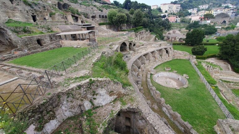
Cuma consisted of two principal zones, the acropolis on Monte di Cuma and the lower city extending across the plain toward the coast. Monte di Cuma is an ancient crater about 80 metres high, with steep tuff cliffs and access from the south. The acropolis formed the earliest urban nucleus, while the lower city developed from the Samnite period onward and expanded particularly during Roman rule. Roads, walls, temples, public buildings, tunnels, baths, harbor installations, and burial grounds preserve the changing organization of the settlement.
Acropolis and Ancient Routes
Acropolis Fortifications
The Via Sacra crossed the acropolis and led toward its principal temples and summit. Its entrance was marked by two towers. One collapsed with part of the hillside, while the other was restored during the Byzantine period and survives as visible ruins. Possible Greek defenses on the southeastern hillside consist of three courses of yellow tuff blocks laid in isodomic masonry, in which blocks are arranged in regular courses of uniform height. Brick and marble inserts and smooth, recessed mouldings were incorporated into the walls. A gate may have stood here on the road toward Pozzuoli and Miseno.
Crypta Romana
The Crypta Romana is a gallery about 300 metres long running beneath the acropolis. Built during the Augustan period by Lucius Cocceius Auctus, a Roman engineer associated with tunnel works in the Phlegraean region, it connected the harbor with the lower city. The passage remained in use until the second century, when collapses blocked it. The surviving section was later used as an Early Christian necropolis, restored by the Byzantines, and partly collapsed during the Gothic Wars in 552.
Cave of Cocceius
Built in the same period as the Crypta, the Cave of Cocceius linked Cuma’s harbor with the harbor on Lake Lucrinus through Monte Grillo. Its straight gallery extends for about one kilometre and varies from five to six metres in width. Six shafts provided light, and a branch leading toward the amphitheater remains partly unexplored. Part of the gallery collapsed during the Second World War after ordnance stored inside exploded.
Temples of the Acropolis
Temple of Apollo
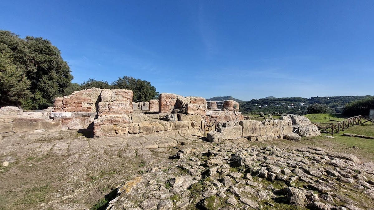
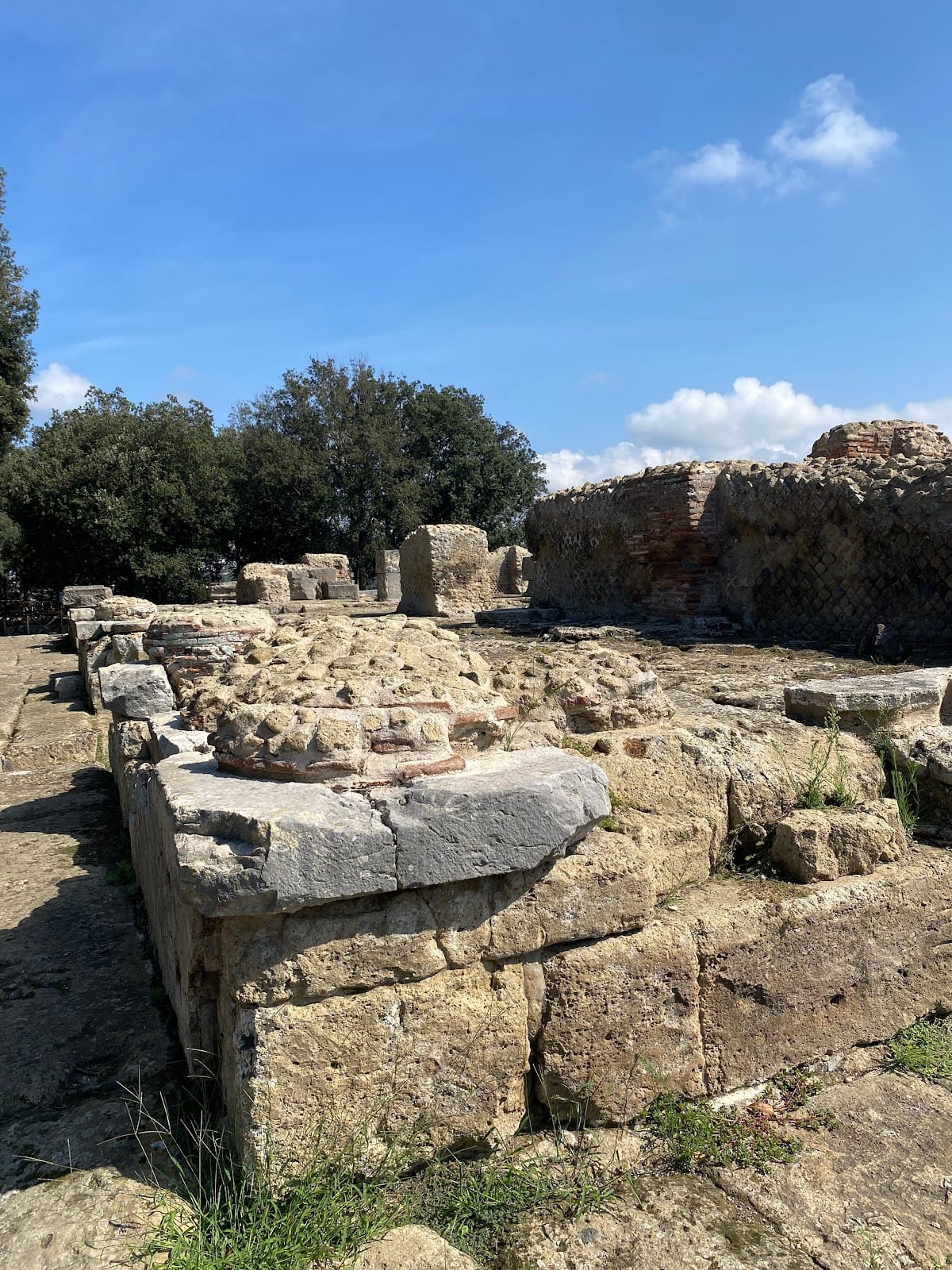
The Temple of Apollo was identified through an inscription referring to Apollo of Cuma. It stands over an earlier temple and has an Ionic peripteral plan, meaning that it was surrounded by a colonnade, with traces of a low tuff podium. During the Augustan period, a porch and a three-part principal chamber were added. Between the sixth and seventh centuries, the building was converted into a Christian basilica. A baptismal font and several graves cut into the floor survive from this later phase.
Temple of Jupiter
The Temple of Jupiter occupied the summit of the acropolis. Built during the sixth century BC, it retains blocks from its tuff foundations, although the western part has partly collapsed and only limited remains survive. In the Augustan period, the temple was reduced to the central part of its base. Between the fifth and sixth centuries, it became a Christian basilica. A presbytery was installed inside the cella, the temple’s enclosed principal chamber, with a marble-faced baptismal font behind it. The font has three steps for full immersion, and graves were cut into the floor.
Sibyl’s Cave
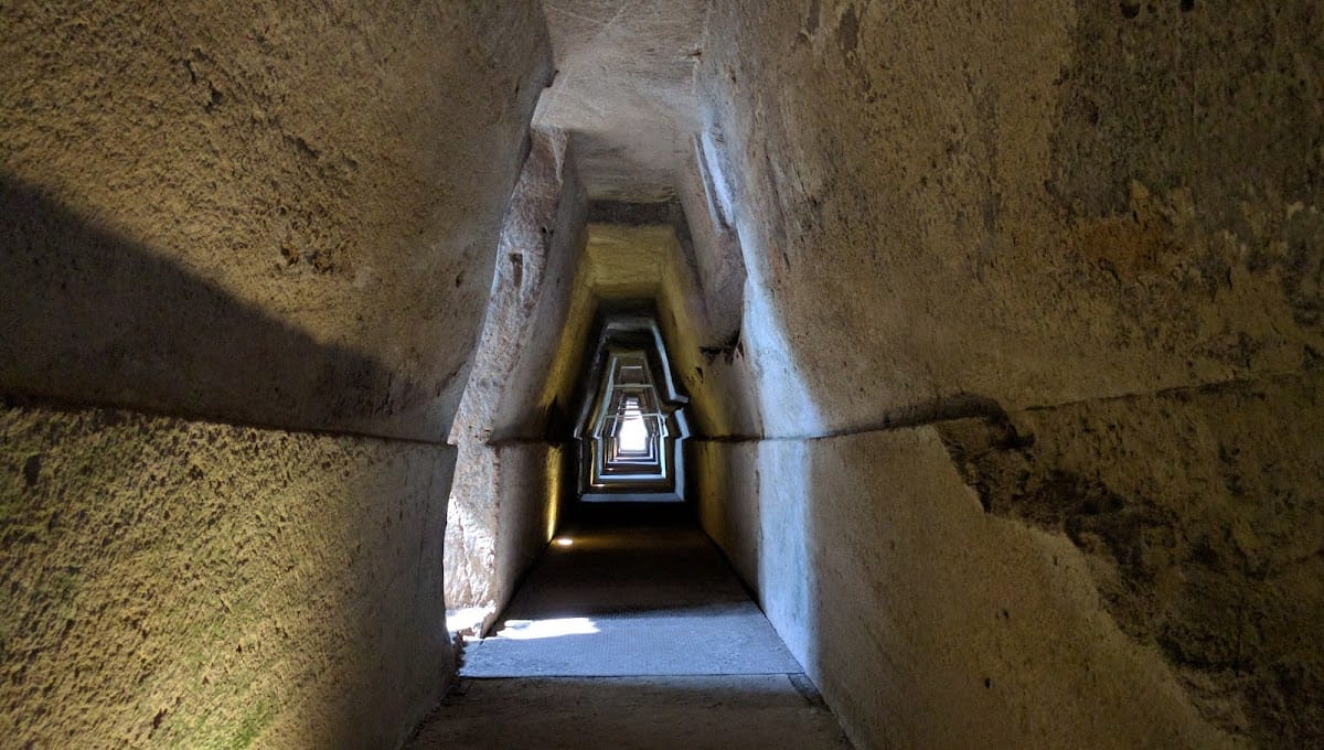
The Sibyl’s Cave is a trapezoidal gallery cut entirely into tuff and extending about 130 metres. At its far end, a vaulted chamber contains three niches. The larger niche on the right resembles a small room and may have been closed by a gate, as indicated by socket holes in the walls. The cave was identified as the place where the Cumaean Sibyl, a prophetic priestess associated with Apollo and Cuma, performed her religious activity. No conclusive evidence establishes that divinations took place there, and some archaeologists have instead interpreted the gallery as a defensive installation.
Other Sacred Structures
Near the Temple of Apollo are the remains of a semicircular building, possibly a tholos, or circular structure, and a trapezoidal building traditionally called a Greek cistern. Because the latter lacks waterproof plaster, it has been interpreted as a thesauros, a sacred treasury for offerings brought by worshippers. Another sacred structure, aligned with the Temple of Apollo and built during the late Republican period, is identified as the Temple of Artemis.
Forum and Public Buildings
Forum
The forum in the lower city was built between the end of the second and the beginning of the first century BC and reorganized during the late Republican period. It remains partly buried and measures about 120 by 50 metres. Two-storey tuff porticoes stood along its northern and southern sides. Their Corinthian-order columns and pillars supported a Doric frieze decorated with triglyphs and metopes, and the porticoes were faced with white stucco.
The pavement was lowered to accommodate a temple and slopes slightly toward a drainage channel for rainwater. A monumental fountain and numerous commercial shops stood around the square. The Temple of Jupiter occupied its centre, the Capitolium stood on the southern side, and the Forum Baths lay to the northwest. Nearby walls built in reticulated masonry, a Roman technique using small stones set in a diagonal net-like pattern, and interrupted by an apse probably belonged to the basilica.
Capitolium
The Capitolium stood at the centre of the forum area. Built in the third century BC and extensively restored during the Imperial period, it measures about 57 by 28 metres. Its Italic plan included a porch and three internal aisles. Marble fragments indicate Corinthian-order architecture, and three heads from Imperial-period cult statues were found there.
Temple with Portico
The Temple with Portico occupied the southern part of the forum and was built during the Julio-Claudian period. Its deity remains unidentified, with interpretations including Hera, Demeter, Vespasian, and a building associated with the Augustales, an imperial-period priestly association linked with the cult of the emperor.
A peperino staircase led to a portico with 24 columns. The columns have disappeared, but their bases and the travertine pavement remain. Two apses at the ends of the portico retain white, yellow, and red coloration. The temple itself consisted of a podium, a porch, and an apsidal cella containing an honorary statue, represented today by its surviving base.
Masseria del Gigante
The building at the Masseria del Gigante was first identified as the Temple of Jupiter and later interpreted as the seat of the magistrates and senate. Dating from the first century BC, it remains largely unexcavated. A staircase leads to a marble-faced podium with a central cella and an apsidal rear wall. The building was originally called the Temple of the Giant because a colossal statue of Jupiter was found nearby.
Harbors and Transport Structures
Arco Felice
The Arco Felice was built in AD 95 to carry the Via Domiziana between the two tuff walls of Monte Grillo. It is about 20 metres high, six metres wide, and 17 metres deep. Two superimposed orders of arches formed a viaduct connecting the sides of the hill. Its piers retain three superimposed statue niches, although part of the monument’s original appearance has been lost.
Harbor Installations
The location of Cuma’s harbor remains uncertain. A possible early Greek harbor occupied an inlet at the foot of the acropolis, which then opened directly onto the sea, and Greek ceramics found in the area support this possibility. Cuma may also have had two harbors within what is now drained Lake Licola.
After the Samnite conquest, the harbor declined. During the Roman period, Marcus Vipsanius Agrippa constructed a new harbor connected by a canal to Lake Fusaro. The harbor included a lock for removing silt. Near the exit of the Crypta, remains interpreted as harbor installations include quays, a dry dock, an approximately eight-metre-high tuff block in reticulated masonry, and a long buttressed wall probably associated with a lighthouse. Agricultural use prevented further investigation in this area.
Baths and Amphitheater
Forum Baths
The Forum Baths were built during the Republican period in the second century BC, restored during the Imperial period, and enlarged in the third century. In the fifth century, some parts were abandoned while other areas were converted into a dwelling or storage space.
One entrance led to the exercise area, or palaestra, and another opened into the vestibule. From the vestibule, a colonnaded corridor led to the cold room, or frigidarium, while other rooms formed a sequence of warm and hot spaces. The hot room, or calidarium, contained three basins. A four-tank cistern supplied the complex. Its rooms had barrel, groin, and basin vaults, with large windows providing light. Marble slabs, black-and-white tessellated mosaics, plaster fragments, and porphyry cornice pieces have been found there.
Central Baths
The Central Baths, once incorrectly identified as the Tomb of the Sibyl, were built between the third and second centuries BC and modified in the first century BC. Discovered at the end of the eighteenth century, they include a large rectangular room with a barrel vault, built in irregular masonry and tuff. Niches for clothing show that it initially served as a changing room. During the Imperial period, it became a warm room, or tepidarium, when a niche containing a washing basin was added. Openings in the vault provided light.
The complex also includes a barrel-vaulted corridor and a cistern lined with cocciopesto, a waterproof Roman mortar containing crushed ceramic material. Marble slabs, stucco fragments, and a marble base for a washing basin were found there. Parts of the complex remain buried beneath excavation spoil and vegetation.
Amphitheater
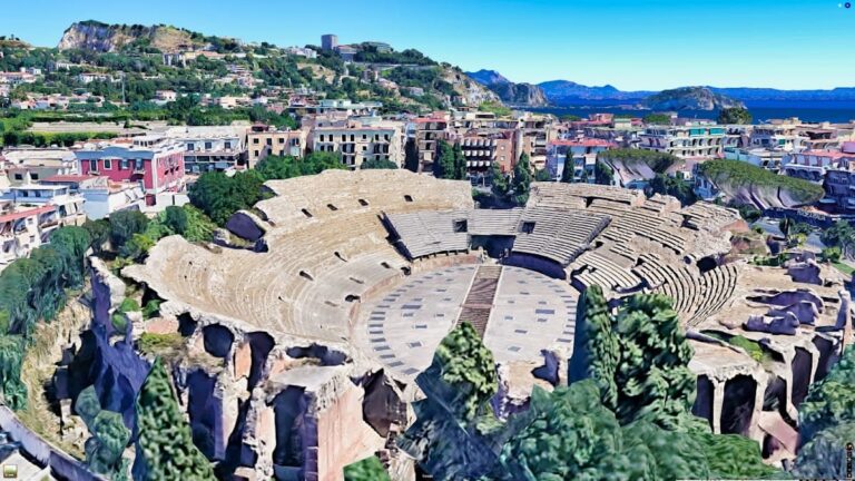
The Roman amphitheater stood outside the city walls and has not yet been excavated, although its form remains recognizable. Built between the second and first centuries BC, it used the slope of Monte Grillo together with an artificial embankment and underwent major restoration in the second century AD. After it lost its original function, furnaces for ceramic production were installed inside between the fifth and sixth centuries.
An orchard now occupies the structure, while the nearly intact arches of the upper seating area remain visible. The major axis measures about 90 metres. The entrances probably lay on the northern and eastern sides, and the marble facing of the seating had already been removed in antiquity.
Necropolises and Tombs
Greek and Samnite Burials
Cuma’s funerary monuments extend across an area about three kilometres long and include Greek, Samnite, and Roman tombs. The earliest burials were mainly cremations associated with wealthy members of the population. Ashes were placed in a bronze cauldron enclosed within a tuff container, while grave goods were deposited inside and around it. These objects could include silver brooches, weapons, clasps, spindles, and spindle whorls, with variations according to the sex of the deceased.
Early ceramic objects are represented by material from southern Etruria and by Attic figure-decorated pottery dating from the sixth and fifth centuries BC. Samnite-period graves included cists made from tuff slabs and, less commonly, chamber tombs with small painted decorations. Their grave goods included red-figure and black-glazed vessels together with gold and silver objects. Two Greek bell kraters found on Luigi Correale’s property depict Triptolemus on a winged chariot and Aurora with Cephalus.
Tholos Tomb
The tholos tomb, partly explored in 1902 and completed under the Kyme project, resembles a mausoleum. It is built of tuff, has a circular plan and conical roof, and contains a series of niches.
Mausoleum of the Wax Heads
The Roman-period necropolis expanded across the surrounding area. The Mausoleum of the Wax Heads, discovered in 1853, was built of tuff and brick and had collapsed internally. Its name comes from four skeletons whose heads had been replaced by wax masks. Finds from the Cumaean necropolises are preserved mainly at the National Archaeological Museum of Naples.