Petra: The Nabataean Capital and Archaeological City in Jordan

Site at a Glance
- Rating
- 4.8
- Popularity
- Very High
- Country
- Jordan
- Primary era
- Classical
- External website
- Open
- Eras represented
- Iron Age, Classical, Medieval
- Civilizations
- Byzantine, Crusader, Kingdom of Jerusalem, Mamluk, Nabataean, Roman
- Site type
- City
On this page28 sections
History
Petra is an ancient Nabataean city and archaeological site in Jordan, built and developed by the Nabataeans from about the fourth or sixth century BC. Located in a mountainous basin between the Dead Sea and the Gulf of Aqaba, it became the capital of the Nabataean Kingdom and a major centre of trade, religion, and water management.
Early settlement and the Nabataean kingdom
The wider region around Petra had been inhabited since prehistoric times, and occupation in the area began by about 1200 BC. The Edomites occupied the surrounding hills and basin before the Nabataeans. They controlled territory at the meeting point of caravan routes, produced pottery and metalwork, and defended their lands from fortified positions on rocky heights. Excavations at Umm el-Biyara indicate an Edomite settlement no earlier than the seventh century BC, while the extent of Edomite occupation within Petra’s basin remains uncertain.
The Nabataeans were an Arab people whose earlier way of life was associated with nomadism. They settled in the region during either the sixth or fourth century BC and gradually took control of Petra. By about 300 BC they had established an urban settlement. Petra was probably the kingdom’s capital by the second century BC, although the city’s foundation date remains debated. Later traditions placed it around 312 BC or as early as the fifth century BC.
Petra prospered because it controlled caravan routes linking southern Arabia with Gaza, Egypt, Syria, Damascus, the Mediterranean, and the Red Sea. Merchants carried spices, aromatics, incense, myrrh, silk, ivory, pearls, turquoise, glass, textiles, henna, wine, olive oil, and wood through the city. Nabataean revenue came from commerce, customs duties, water provision, and arrangements for overnight shelter.
In 312 BC, Antigonus the One-Eyed sent the general Athenaeus against Petra to collect taxes paid in spices. The city was entered while many men were away on pilgrimage, but returning Nabataean pilgrims defeated the raiders and recovered their families and property. A later expedition led by Demetrius ended when hostages and gifts were accepted instead of an assault.
Expansion and royal building
Petra and the Nabataeans resisted Seleucid, Hasmonean, and Roman expansion for substantial periods. King Obodas I defeated Alexander Jannaeus between 93 and 90 BC and Antiochus XII in 85 BC. After his death, the Nabataeans deified Obodas and incorporated him into their religious tradition.
Under Aretas III, the Nabataean kingdom expanded to Damascus. During the reign of Aretas IV, approximately from 9 BC to AD 40, the kingdom experienced major cultural and architectural growth. Many of Petra’s tombs and temples were built during this period. The city’s religion included the deified Obodas I and the principal male deity Dushara, together with the female deities Al-Uzza, Allat, and Manat. Petra was both a commercial capital and a major religious centre, with approximately 680 cultic monuments recorded at the site by 1998.
Roman annexation and Christian Petra
Rome annexed the Nabataean Kingdom in AD 106, probably after the death of Rabbel II and without a major battle, under the authority of Aulus Cornelius Palma, the governor of Syria. The annexed territory became the Roman province of Arabia Petraea, and Bosra became its capital. Petra received the honorary title of metropolis, while Roman roads connected it with Bosra and the Gulf of Aqaba.
Petra continued to prosper for a time under Roman rule. The growth of maritime trade and Roman control of the principal commercial routes gradually reduced its importance, while Palmyra also drew trade away. The city retained religious and administrative importance, however. The emperor Hadrian visited Petra in AD 130, when it was given the name Hadriana Petra Metropolis.
Christianity spread in Petra during the fourth century. A bishop was present by about 350, and large churches were built during the following century. Earlier Nabataean structures were adapted for Christian use, including the Deir and the Urn Tomb. The latter became a church or cathedral in AD 446.
Earthquakes, decline, and later history
Earthquakes damaged Petra in AD 363, 419, 551, and 747. The earthquake of 19 May 363 damaged the theatre, monuments, and water-supply systems, and contemporary testimony states that almost half the city was destroyed. As commercial activity diminished, Petra declined, although documentary evidence and excavated churches show that it still flourished during the sixth-century Byzantine period. By about AD 700 it had become a village or sparsely inhabited settlement. Later earthquakes, especially those of 746 and 748, contributed to its abandonment.
During the Crusader period, Petra formed part of the lordship of Oultrejordain and the barony of al-Karak under Baldwin I of Jerusalem. Crusader fortifications were built at al-Wu’ayra and al-Habis. Mamluk authorities later established a shrine to Aaron on Mount Hor, also called Jabal Haroun, continuing traditions that connected the region with Moses and Aaron. Wadi Musa was identified as the Valley of Moses, while Jabal Haroun was traditionally regarded as Aaron’s burial place. These traditions contributed to pilgrimage and later helped Johann Ludwig Burckhardt gain entry to the ruins.
Rediscovery, research, and conservation
Petra gradually disappeared from wider knowledge during the Ottoman period. On 22 August 1812, Johann Ludwig Burckhardt entered the ruins in disguise as an Arab pilgrim under the name Sheikh Ibrahim. He claimed that he intended to sacrifice a goat at Aaron’s tomb, recognized the remains as Petra, and publicized them in the western world through a travel account published after his death.
William John Bankes and other travellers visited Petra in 1818. The first major archaeological expedition followed in 1828, when Leon de Laborde and Louis-Maurice-Adolphe Linant de Bellefonds spent six days surveying the site. Their detailed map and drawings were published in 1830. Later research expanded from the most spectacular tombs to inscriptions, domestic quarters, water systems, civic buildings, and everyday objects. Important investigations included Diana Kirkbride’s work at nearby Beidha, Crystal-M. Bennett’s excavation of the Edomite settlement at Umm el-Biyara, the work of George and Agnes Conway in 1929, and investigations by the Department of Antiquities of Jordan after 1946.
Excavation and conservation intensified after 1954. Research at Qasr al-Bint, the Great Temple, the Byzantine Church, the Temple of the Winged Lions, the Wadi Farasa complex, the Khazneh, and other sectors has continued into the twenty-first century. A major campaign from 1993 to 2002 uncovered, among other remains, a large pool complex near the Great Temple. By 2020, about 6 percent of Petra was estimated to be known. Archaeologists have recorded roughly 3,000 archaeological features, including about 800 commonly identified or presented as major monuments. Excavations have recovered inscriptions, coins, ceramics, papyri, sculpture, and evidence for domestic, religious, agricultural, and commercial activity.
Petra was inscribed on the UNESCO World Heritage List in 1985 under cultural criteria i, iii, and iv. The surrounding archaeological area became an archaeological park in the 1990s, and the Petra Archaeological Park became an autonomous legal entity in 2007. Conservation has addressed earthquake damage, erosion, flooding, salt weathering, unstable rock, drainage, inappropriate restoration, heavy visitation, and the protection of painted surfaces, tomb façades, streets, temples, and water systems. The Petra National Trust was established in 1989, and the Petra Development and Tourism Region Authority, created in 2009, administers regional development and tourism-related programmes.
The Bedul Bedouin communities, who had lived in caves and other parts of Petra, were relocated by the Jordanian government during the 1980s, including to Umm Sayhoun, before or around the UNESCO designation process. Their traditional cultural heritage and skills were proclaimed by UNESCO in 2005 and inscribed on the Intangible Cultural Heritage List in 2008. Local communities continue to participate in preserving the site and in the tourism economy.
Remains
Petra occupies a mountainous basin on the eastern flank of the Arabah valley. Steep sandstone escarpments and wadis surround the central city, which lies at elevations broadly ranging from about 800 to 1,396 metres within an archaeological reserve of approximately 264 square kilometres. Wadi Musa forms the principal natural axis, crossing the site from east to west. The city was arranged on natural terraces and along valley walls rather than on a regular grid, while walls were concentrated particularly on the more exposed northern and southern sides.
Eastern entrance and water system
The Siq
The Siq, the principal eastern entrance, is a natural gorge formed by a deep fracture in the sandstone. It extends for about 1.2 to 1.5 kilometres, varies from approximately 3 to 12 metres in width, and reaches about 80 to 200 metres in depth in places. Nabataean engineers modified parts of the gorge, whose floor was paved in antiquity. A large city gate or arch once rose about 16 metres above its entrance. Erosion, earthquakes, and floods destroyed the arch by 1896, although traces remain on the canyon wall.
Niches containing divine images were cut along the Siq, and channels ran beside the gorge. Dams, plaster-lined conduits, and ceramic pipes carried or controlled water from springs and runoff. Nabataean sculptures and niches included the group known as the Sabinos idols, as well as reliefs of camels and a man associated with a caravan.
Water management and agriculture
Petra’s water system included dams, cisterns, reservoirs, channels, aqueducts, plaster-lined galleries, ceramic pipes, wells, and a public fountain or nymphaeum, a monumental water feature. Approximately 200 cisterns are recorded, including many on Umm el-Biyara, and the system is estimated to have supplied as much as 40 million litres of water per day. Terraces around the site helped control erosion and improve agricultural yields. Probable crops included barley, wheat, fruit trees, and vines, while rock-cut wine presses, probably dating from the Roman period, have also been identified.
Monumental centre
The Colonnaded Street
The Colonnaded Street runs through the monumental centre along the southern side of Wadi Musa. It is approximately 6 metres wide and was rebuilt or remodelled under Roman rule after AD 106. Buildings of one and two storeys lined the route, and stairs led south to an open market area. The street continued in use during the Byzantine period and formed part of a later urban arrangement that also included straighter streets, colonnades, bridges, drainage channels, and vaulted structures over seasonal watercourses.
The Great Temple and Petra Pool
The Great Temple, south of the Colonnaded Street, formed one of Petra’s largest complexes. Its plan included a main entrance, a lower sacred court, matching semicircular buildings, broad stairways, an upper sacred court, and a temple or sanctuary at the rear. Nearby, the Petra Pool and Garden Complex contained a large pool, an island pavilion, and an elaborate hydraulic system. The complex was once interpreted as a market.
Qasr al-Bint
Qasr al-Bint, also called Qasr Bint Firaun, is a rare major structure built rather than cut from the rock. The sandstone temple, about 23 metres high, was constructed in the first century BC beside a broad paved esplanade and colonnade. Juniper beams were incorporated into its walls as an anti-seismic measure, and the building suffered partial destruction in an earthquake.
Inside, a raised rear platform was reached by two stairways. Its cult image was associated with Dushara, although proposals have also connected the temple with Allat, Al-Uzza, or Isis. A Roman-period niche in the forecourt commemorated the emperor and his family. Excavations beneath the sacred precinct revealed remains of an earlier or additional temple.
The Temple of the Winged Lions
The Temple of the Winged Lions stood opposite Qasr al-Bint on the northern side of Wadi Musa. Built during the first century, probably under Aretas IV, it had a long staircase, a columned entrance, a square cult hall, and a raised podium. Its Corinthian capitals were decorated with winged lions. Marble paving, coloured plaster, stucco decoration, floral designs, human heads, theatrical masks, and niches for offerings or cult images formed part of the interior. The complex was destroyed and abandoned after the earthquake of AD 363.
The Theatre
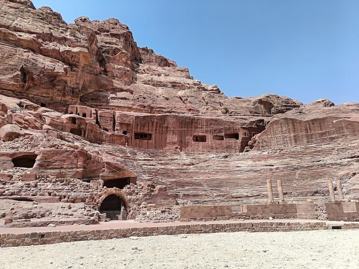
The Roman or Nabataean theatre was built in the first century AD, partly cut into the hillside and into earlier tombs. It has a semicircular orchestra, three seating levels, and approximately 45 rows divided by stairways. Its reported capacity ranges from about 3,000 to 10,000 spectators. The stage wall originally had three storeys, columns, niches, and marble facing. The earthquake of AD 363 caused major damage to the theatre.
Rock-cut façades and tombs
The Khazneh
The Khazneh, or Treasury, stands at the end of the Siq and is cut into a sandstone cliff. Its façade is approximately 24 to 25 metres wide and 37 to 39 metres high. Two storeys contain six lower columns, a central staircase, a broken pediment, a central circular feature called a tholos, obelisks, and imagery combining Egyptian, Hellenistic, and Nabataean traditions.
The upper façade includes a female figure generally interpreted as Isis-Tyche, while figures of Castor and Pollux appear near the lower section. The urn at the top gave rise to the local name Treasury because of an earlier belief that it contained treasure. The building is generally interpreted as a royal tomb, probably associated with Aretas IV, although its date and precise function remain debated. Three interior chambers consist of two lateral rooms and a central chamber reached by stairs. Tombs were cut beneath the forecourt, and a western side chamber contains another grave.
The Deir
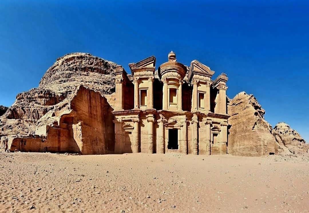
The Deir, or Monastery, is Petra’s largest monument. It is carved into a rock face on a high plateau and measures approximately 45 to 50 metres in width and 42 to 50 metres in height. Its two-storey façade combines a large broken pediment and central tholos with Nabataean and Hellenistic features. The open area before it was deliberately levelled and may have served worshippers.
The Deir’s construction date is uncertain, with proposed dates ranging from the first half of the first century BC to approximately AD 40 to 70. It was probably connected with the cult of the deified Obodas I, and a nearby inscription refers to a religious association or foundation. During the Byzantine period, the building was used as a Christian monastery or church, giving rise to its later name. Crosses were painted or carved inside.
The Royal Tombs
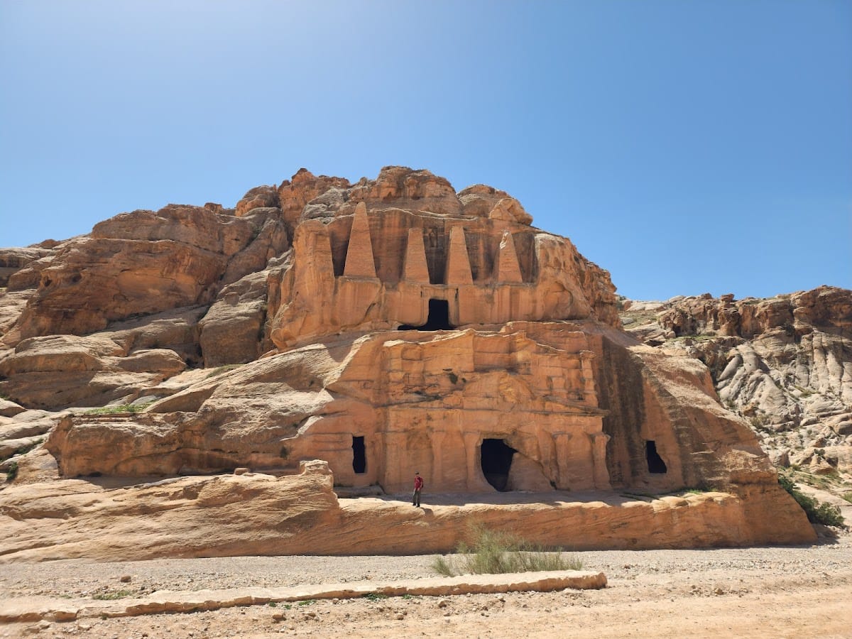
The Urn Tomb is a large rock-cut monument with a broad forecourt and forms part of the Royal Tombs. It is generally dated to the first century and has been associated with Malichos II or Aretas IV. In AD 446 it was converted into a church, and a Greek inscription records the consecration or conversion.
The Court complex, centred on the Urn Tomb, has a façade approximately 16 metres wide and 26 metres high. Its two levels include walls supporting arches below the burial hall, a mixture of rock-cut and built burial chambers, and stairs leading to an upper court about 19 metres square. The complex was converted into a church in AD 447, as recorded by a Greek inscription.
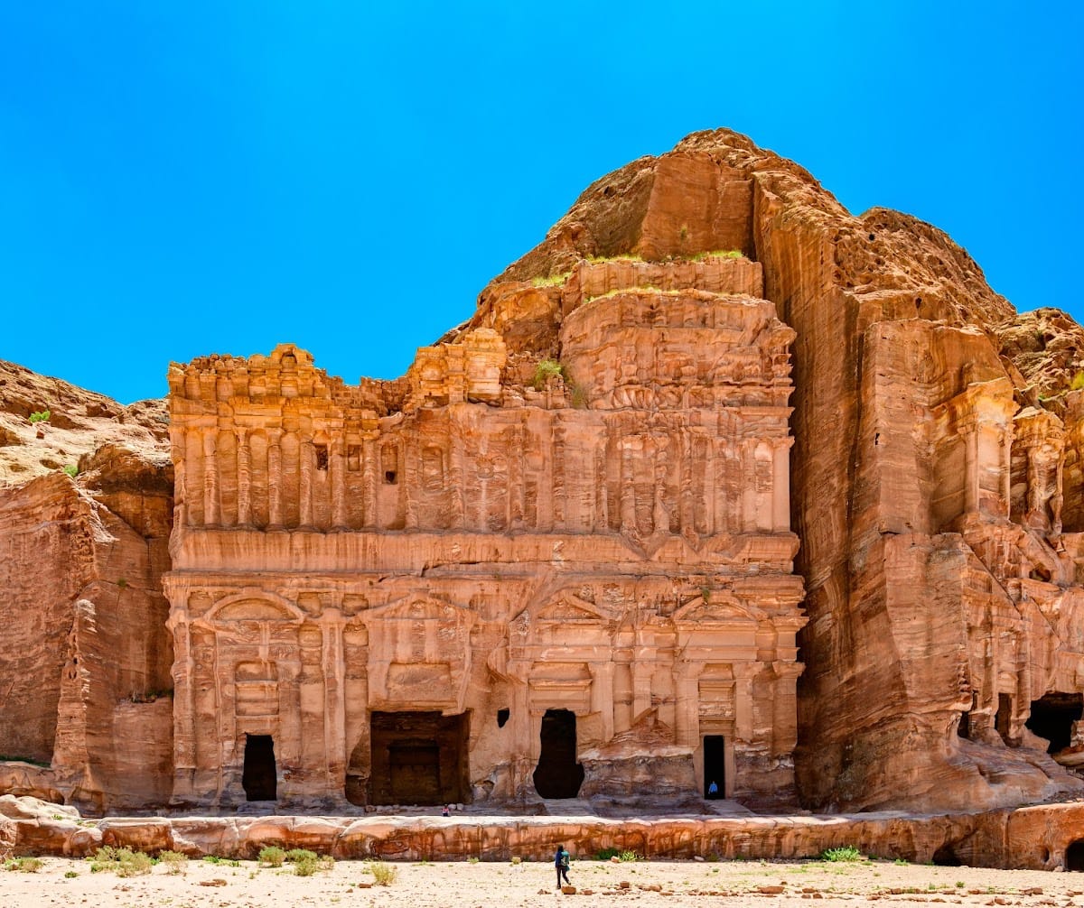
Other major Royal Tombs include the Palace Tomb, the Corinthian Tomb, and the Silk Tomb. Their façades display Hellenistic architectural forms, while natural decay has worn many of their surfaces. The Palace Tomb may have served as a royal burial place. Petra’s wider necropoleis include the Soldier Tomb, Renaissance Tomb, Turkmaniyeh Tomb, Sextius Florentinus Tomb, and other funerary monuments. The city had at least 620 monumental tombs in addition to numerous pit graves.
Religious and residential areas
The High Place of Sacrifice
The High Place of Sacrifice, or al-Madhbah, occupies the summit of Jabal al-Madhbah. A processional route and long stairway led from the theatre to the summit. The sanctuary includes a central open court surrounded by benches, two rock-cut obelisks associated with Nabataean deities, rectangular and circular altars, and a small pool or water tank. Animal sacrifice, libations, and the burning of incense are associated with the site.
The Wadi Farasa complex
The Wadi Farasa complex includes the Soldier Tomb, the Painted Triclinium, hydraulic installations, a lower terrace, and a possible upper-terrace Garden Temple with a peristyle house and cistern. A triclinium was a formal dining or banquet room, often used for funerary or ceremonial purposes. In its late first-century BC form, the complex consisted of a rock-cut tomb and banquet hall on opposite sides of the wadi, joined by a peristyle. Hypocaust remains, evidence of an underfloor heating system, have raised the possibility that part of the complex included a residence.
The Nabataeans first used temporary tents before creating simple rock-cut residential quarters. These had smooth façades, low entrances, and one or two stepped cuts. Private houses generally had flat roofs, few or no windows, small internal courtyards, stone-paved floors, and stone benches. Kitchens were often placed in separate buildings to reduce fire risk.
Byzantine and later remains
The Byzantine Church
A Byzantine Church north of the Colonnaded Street was built in the fifth century. Its decoration included mosaics made from glass and stone tesserae, some covered with gold leaf. A fire late in the fifth century damaged its furnishings. Excavations recovered more than 4,000 marble fragments and over 140 papyri from the church and an adjoining room.
The papyri contain documents and contracts dating mainly from the 530s to the 590s. Greek documents and scrolls were also discovered in a church excavated near the Temple of the Winged Lions. Together, these remains provide evidence for Petra’s Christian institutions and continued activity during the Byzantine period.
Jabal Haroun shrine
The shrine of Aaron on Jabal Haroun is a small Mamluk mosque and memorial structure at an elevation of about 1,353 metres. It has a domed white roof and a small decorated chamber. The shrine was restored under Sultan al-Nasir Muhammad ibn Qalawun.
Crusader fortifications
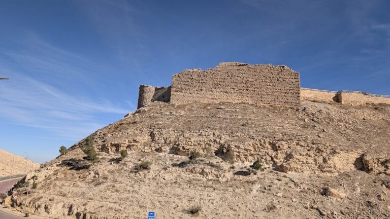
The Crusader castles of al-Wu’ayra and al-Habis are located in and around Petra. Al-Wu’ayra lies north of Wadi Musa, while al-Habis occupies a summit in the heart of Petra near Qasr al-Bint.
Construction, decoration, and continuing discovery
Petra’s sandstone varies from red-brown to pink, yellow, orange, purple, and other colours. Stratified surfaces, cross-bedding, iron and manganese oxides, joints, and differential erosion produced the coloured rock faces, tafoni, caves, and other natural formations. Most monumental façades were cut directly into sandstone, while builders also used dressed stone, limestone, basalt, mud brick, stucco, marble, granite, timber, and terracotta.
Petra’s architecture combines local Nabataean forms with Egyptian, Assyrian, Hellenistic, Alexandrian, Roman, and Byzantine elements. Cornices, friezes, architraves, pilasters, Corinthian capitals, rosettes, stepped battlements, horns, sphinxes, griffins, Medusa heads, lions, eagles, elephants, and floral motifs appear across the city’s buildings and façades.
A large structure identified through aerial and satellite imagery in 2016 lies about 800 metres south of the city centre at the foot of Jabal al-Nmayr. Tentatively dated to about 150 BC, it consists of a platform approximately 56 by 49 metres, an eastern monumental staircase, a smaller enclosed platform, and a building about 8.5 by 8.5 metres. Its ceremonial function remains uncertain.