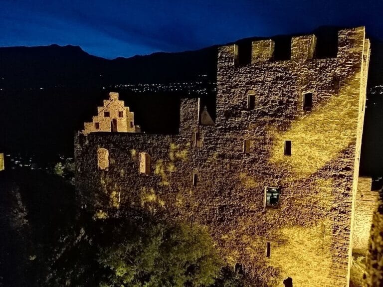
Beauregard Castle: A Medieval Rock Fortress in Switzerland


Site at a Glance
- Rating
- 4.8
- Popularity
- Very Low
- Country
- Switzerland
- Primary era
- Medieval
- External website
- Open
- Eras represented
- Medieval
- Civilizations
- Unclassified
- Site type
- Military
- Remains
- Castle
On this page17 sections
History
Beauregard Castle is a medieval rock castle in Switzerland, positioned above Chippis at the entrance to the Val d’Anniviers. Its architecture most probably dates from the twelfth century, although an eleventh- to twelfth-century origin remains possible. The original builder and purpose are uncertain. Set on a rocky spur about 500 metres above Chippis, at roughly 1,012 to 1,013 metres above sea level, it overlooked the Rhône valley and part of the Val d’Anniviers. Its commanding position gave it the traditional nickname “the Impregnable.”
Origins and Territorial Role
Some historians once proposed that the castle was built in 1097, but that date is unsupported. The regional archives mention the site only twice, first in a 1457 deed under the name “bel regard” and later on a 1545 map as “Perigard.” Beauregard formed part of the territory of Sierre, north of Petra Letzi, a natural boundary rock that separated Anniviers and Sierre along the Navizence.
The castle probably belonged to the Raron family before 1380. Other possible owners include the Albi family, the de la Tour family, and the Knights of Sierre, but its original ownership cannot be established. Its function is equally uncertain. It may have guarded the entrance to the Val d’Anniviers or a route along the left bank of the Rhône. It may also have served as an observation and fire-signalling post, or as a final refuge for its owners.
The Raron Conflicts
Beauregard became involved in the political struggles of the Raron family during the late fourteenth century. After Jacques II of Anniviers died without sons, the lordship of the Val d’Anniviers first passed to Aymon de Challant. Pierre de Rarogne, Count of Sierre and the husband of Jacques’s daughter Béatrice, then purchased it for 1,700 florins.
In the 1380s, Pierre de Rarogne led a revolt against Edward of Savoy-Achaea, the Bishop of Sion. Pierre seized the episcopal castles of Tourbillon, Majorie, and Soie. Amadeus VII, Count of Savoy, intervened militarily and restored the bishop’s possessions. In October 1387, Amadeus attacked Raron holdings in the Val d’Anniviers and besieged Beauregard while Pierre was inside.
Savoyard troops approached from the upper mountainside, outflanking the castle, while Amadeus attacked the Anniviards who came to Pierre’s aid. The fortress was captured. Pierre’s sons, Petermann and Heinzmann, were imprisoned and hanged on the Grand-Pont in Sion. Beauregard suffered damage in the assault, but the Raron family soon repaired it.
The Raron Affair and Destruction
The Raron family remained politically powerful in the early fifteenth century. In 1414, Sigismund of Luxembourg, Holy Roman Emperor, granted Witschard de Rarogne all sovereign rights over Valais. The grant helped provoke the Raron affair, a rebellion by the Valaisan communes against the family’s authority.
Between 1416 and 1417, the communes attacked Raron properties, including Beauregard. After a prolonged siege, hunger and thirst forced the defenders to surrender. The castle was then burned and never rebuilt. Witschard de Rarogne was exiled, although he recovered the lordship of Anniviers in 1420. An ash layer in the castle’s spiral stairwell preserves physical evidence of the burning.
Investigation and Protection
Louis Blondel made the first survey of the ruins in 1951 and interpreted Beauregard as a simple watchtower. The site had not undergone archaeological excavation by the beginning of the twenty-first century. Bernard de Preux proposed an investigation in 2005, and in 2008 the Swiss Heritage Society and the communes of Chippis and Sierre created the Beauregard Castle Foundation to organize and finance the work.
A preliminary field survey followed in 2008. After cantonal authorization, the summit of the hill was cleared and lowered by nine metres. Excavations led by Alessandra Antonini from 2009 to 2011 revealed much of the castle’s perimeter and surviving ruins. In 2016, protective measures were placed over the cistern and spiral stairwell. The Beauregard Castle Foundation owns the property. In 2017, a secured approach from Niouc was completed, including a short via ferrata, a route across exposed rock equipped with fixed cables and other metal aids.
Remains
Beauregard was a small enclosed rock-fortification complex measuring about 30 metres by 20 metres. Its buildings, courtyard, cistern, and defensive features occupied the summit of a rocky spur within an enclosing defensive wall. The surviving remains are arranged around lower and upper courtyard areas, with the principal dwelling, a tower, water installations, and later wooden rooms adapted to the uneven rock.
Approach and Courtyards
Bridge and Gates
Medieval access began with a wooden bridge about two metres wide and nine metres long, spanning a moat. At the eastern approach, it crossed a wall built directly on the rock. This wall, approximately three to four metres high, also formed the first gate. The middle section of the bridge rested on wooden uprights set into the rock, and the deck could be dismantled during an attack.
On the castle side, the bridge followed the rocky spur and ended at the southeast side of the enclosing wall. Notches cut into the eastern rock face mark supports for horizontal bridge beams. Further notches at the southern base indicate an initial staircase leading to a landing and then to four more steps at the main gate.
Lower and Upper Courtyards
The courtyard was divided into lower and upper sections. The lower courtyard on the eastern side served as a guardhouse and entrance passage to the main gate. It measured between 1.6 and 3 metres in width. A second gate separated it from the upper courtyard and was probably added after the Savoyard assault of 1387.
Water Supply and Southern Tower
Cistern
A circular cistern supplied the castle with water. It is 2.25 metres deep, 2.10 metres in diameter at the base, and 1.90 metres across at the neck, with an estimated capacity of 6,000 litres. The circular structure was built inside an earlier rectangular cistern. The conversion date is unknown, although the circular cistern probably existed by 1387.
Five slabs of slate schist form the floor. The vertical walls consist of cut rauhwacke blocks, a porous weathered carbonate rock, backed by a watertight inner layer of olive-green clay silt. A rauhwacke channel around the neck carried surplus water eastward. A western spillway may also have existed, but that side of the cistern has collapsed. Its construction is described as unique in Valais. A protective cover now prevents falls and the accumulation of leaves.
Southwestern Tower
A small staircase in the southwest of the enclosing wall led west to a rectangular tower measuring three by five metres. Its lower floor served as an attic or storage area, while the second floor was used to watch the southwestern ridge. The stairway continued westward over a postern, a secondary entrance opening onto a steep ridge path. The tower’s wider function remains uncertain.
Main Dwelling and Upper Terrace
Rectangular Dwelling
The main building was a rectangular dwelling measuring eight by nine metres. Its surviving northern wall contains a loophole and a second asymmetrical opening positioned 70 centimetres lower. The north and west walls were each 1.6 metres thick, while the eastern wall measured 2.5 metres. Facing the natural moat, the eastern wall may have been accompanied by a glacis, a sloping defensive surface intended to expose attackers to fire.
Entry to the dwelling was through the west wall and a spiral stairwell. Traces of the doorway threshold beams survive in the floor and west wall. The stairwell was added after the initial construction of the castle and also connected the upper floor with the upper terrace. Its roof now protects the surviving structure.
Defensive Platform and Burn Layer
An intact cannonball found in 2010 among the remains of the upper-floor beams was probably stored on that floor. The upper level may have functioned as a defensive platform. The ball’s form indicates that it was intended for a bombard, a large medieval gun that fired stone or metal balls, rather than for a catapult.
The ash layer in the stairwell relates the surviving fabric to the castle’s destruction during the Raron affair. It provides physical evidence that fire reached the building when Beauregard was captured and burned in the early fifteenth century.
Wooden Terrace Building
The upper terrace contained a wooden building divided into western and eastern rooms, each about 24 square metres. The western room was reached by a staircase north of the cistern, while the eastern room was entered through the spiral stairwell. This building belonged to the castle’s final transformation. Masonry cuts in the stairwell and the western staircase’s encroachment on the cistern rim show how the later arrangement was fitted into the earlier structures.
The western room was attached to the main building. Its southern facade included a low wall 30 centimetres thick, forming the side of the doorway into the stairwell. The wall appears to have rested directly on the rock. The eastern room was probably similar, although its southwest corner was more massive because it crossed the different levels of the upper terrace and cistern.
Latrine and Terrace Features
Southwest of the upper terrace, above a natural fissure, a masonry base measuring 1.6 by 1.4 metres supported a latrine. Its use may have been reserved for the garrison, while the lords’ latrines were probably located on the second floor of the main dwelling. An oak stood in the middle of the upper terrace, which extends toward views of the Rhône valley, Sion, Chippis, Sierre, and Crans-Montana.