Craigie Castle: A Medieval Wallace Stronghold in Scotland


Site at a Glance
- Rating
- 4.3
- Popularity
- Very Low
- Country
- United Kingdom
- Primary era
- Medieval
- Eras represented
- Medieval
- Civilizations
- Kingdom of Scotland
- Site type
- Military
- Remains
- Castle
On this page9 sections
History
Craigie Castle is a ruined medieval stronghold in Scotland, built for the Lindsay family in the old Barony of Craigie. Its earliest phase is uncertain, dating possibly from the twelfth or thirteenth century, and it is regarded as one of South Ayrshire’s earliest buildings. The present ruins are mainly fifteenth-century, although parts of the fabric may belong to the earlier castle.
The Hose and Lindsay lordships
During the twelfth century, Walter Hose held the Craigie fief from Walter fitz Alan, the hereditary Steward of Scotland. In 1177, Walter Hose of Craigie granted the church of Craigie to the monks of Paisley. The Hose family was later succeeded by the Lindsays. Their male line eventually ended when the Lindsay heiress married John Wallace of Riccarton around 1371.
That marriage brought Craigie Castle into the Wallace family, and it became the principal residence of the Ayrshire Wallaces. The family remained there until 1588, when it moved to Newton Castle in Ayr. Craigie Castle was then left to decay. Newton Castle, also known as Sanquhar Castle, was badly damaged by a storm in 1701 and demolished during the second half of the eighteenth century.
The Ayrshire Wallaces
The Wallaces of Craigie held the hereditary bailieship of Kyle Stewart. A bailie was a local magistrate or civic official, so this inherited office made the family important representatives of the Crown in the district. Their influence declined after Adam Wallace became involved in the 1527 murder of Gilbert Kennedy, second Earl of Cassillis, during a feud connected with the Campbells.
Members of the family took part in several major conflicts and political movements. John Wallace served as lieutenant-general to James II, the fifteenth-century Scottish king. He fought at the Battle of Sark in 1448 and died from his wounds at Craigie Castle about three months later. Other Wallaces supported the Scottish Reformers in 1559, the Royalist cause during the wars of Charles I and Charles II, and the Jacobite cause under James VII, who was also James II of England.
Sir Hugh Wallace’s estate was sequestered because of his Royalist activities and was later restored under Charles II. His military spending helped create heavy debts, leading to the sale of lands and the disposal of the hereditary Kyle bailieship to the Crown in 1626. The family’s baronetcy, a hereditary title ranking below a barony, later passed through Thomas Dunlop, who sold the Craigie estate in 1783.
Traditions, decline, and abandonment
A tradition preserved by Frances Dunlop of Dunlop, a lineal descendant of William Wallace, identifies Craigie Castle as the birthplace of William Wallace in his grandfather’s house. The story explains his departure by saying that the growing family had outgrown the available space. This birthplace tradition is not certain.
Another local story connects the castle’s decline with Sir Hugh Wallace’s alleged disregard for Presbyterian Sabbath discipline and his dispute with a minister. According to the tale, the minister foretold the castle’s destruction, after which part of the building collapsed during attempted repairs. The supernatural element belongs to legend, although the story may preserve a memory of Sir Hugh’s opposition to Presbyterianism.
Paterson recorded that repairs were being made to the tower at the end of the seventeenth century when part of the roof fell in. The castle was then completely abandoned. Timothy Pont’s map of about 1600 marks “Kragy Castle” on an elevated site with a prominent entrance, wooded surroundings, and a surrounding fence. The nearby route later known as the B730 formed part of the historic road from Irvine to Dumfries through Sanquhar, with a connection to the Ayr to Kilmarnock road. By 1752, the surrounding area was intensively cultivated.
Later associations and protection
Craigie House in Ayr was built during the 1730s as a replacement residence for Sir Thomas Wallace of Newton-on-Ayr Castle. After the Craigie estate was sold in 1783, it remained with the Campbell family for several generations before Ayr Town Council acquired it in 1940. Craigie Castle itself is protected as a scheduled monument under Scottish heritage law. Its importance also rests on its early date and on the exceptional quality attributed to its medieval vaulted hall.
Remains
Setting and defensive enclosure
The ruins stand on a knoll rising from a plateau, between two marshes or natural lochans. The castle was enclosed by ditches and wet ground covering about 4 acres, or approximately 1.6 hectares. A ditch cut across the ridge 117 metres north-east of the castle and formed an outer bailey, an enclosed defensive area beyond the principal building. Further ditches lay near the southern and western sides. Together with the marshes, these features created a substantial obstacle and exposed anyone crossing them to crossfire and flanking fire.
The entrance lay on the south-west side and was approached by a drawbridge, whose abutment survives. The entrance passage, or pend, was defended by a circular watchtower or projecting defensive platform. A courtyard occupied the area inside the enclosing wall, with surrounding buildings and a route to the great hall through an entrance that was later blocked.
The medieval hall
The main building was a high-quality, three-bay hall with a rib-vaulted ceiling, meaning that stone ribs supported the vault above. It stood over an unvaulted basement with a flat or non-vaulted ceiling. Architectural historians have identified traces of an earlier hall whose crenellated parapet rose flush with the main wall face.
The first building was probably a simple rectangular hall-house, a medieval residence centred on a principal hall and combined with defensive features. It may have carried a broad crenellated parapet and a saddleback roof. During the fifteenth century, the earlier crenellations appear to have been built over, and a new hall was constructed within the walls of its predecessor. The ruined condition makes the original plan uncertain.
One wall contained a round-arched doorway. Opposite it was a late-medieval fireplace, inserted during the fifteenth century above another round-arched opening. The vaulted hall has been described as one of the finest examples of its type in Scotland, with comparisons to the halls at Tulliallan, Bothwell, and Auchendoun. It has also been regarded as possibly the most impressive building of its kind in Ayrshire.
Surviving fabric and associated features
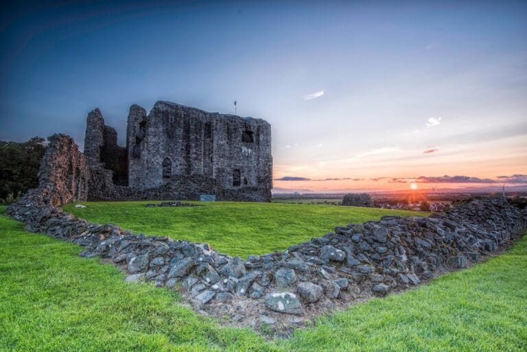
Craigie Castle now consists of two crumbling gables, sections of wall, and fragments of battlements. Several underground vaulted chambers survived into the nineteenth century. They were partly filled with rubbish and used by foxes and bats. An armorial plaque removed from the ruins is built into the wall of the steading at Craigie Mains. It carries the impaled arms of the Lindsays and Wallaces, although local tradition mistakenly interpreted the figures as two wild men playing draughts.
A likely crannog, a dwelling or artificial settlement in or beside wet ground, was visible during the nineteenth century in a boggy hollow just south-west of the castle. It appeared as a slight, stone-filled rise in a meadow, and an oar was found when the hollow was drained. The nearby barony was also associated with moot or justice hills and a gallows hill. Three Borland farms near Craigie village may have supplied the castle or its servants, since the name could refer to land set aside for that purpose, and Pont’s map marks a “Boirland.”
Antiquarian examination has helped preserve knowledge of the site’s wider setting. In 1895, John Smith recorded three trenches around the castle and described a deep trench north-east of it that connected two marshy areas. These features, together with the surviving masonry and vaulted hall, show how the castle’s buildings were integrated with a carefully enclosed wetland landscape.
Nearby sites