Alt-Haldenstein Castle: A Medieval Rock Fortress in Switzerland


Site at a Glance
- Rating
- 4.5
- Popularity
- Very Low
- Country
- Switzerland
- Primary era
- Medieval
- External website
- Open
- Eras represented
- Medieval
- Civilizations
- Holy Roman Empire
- Site type
- Military
- Remains
- Castle
On this page8 sections
History
Alt-Haldenstein Castle is a medieval rock castle in Switzerland, above Haldenstein, whose oldest surviving parts date from the twelfth century. Built during the Middle Ages on a technically demanding rocky outcrop, it was one of three castles in the municipality, alongside Grottenstein and Lichtenstein. Its restricted position suggests that it was probably the latest of the three to be established.
The Haldenstein family and the lordship
The castle was associated with the Haldenstein family, a ministerialis family whose members held offices, estates, or military responsibilities for higher lords despite not belonging to the highest hereditary nobility. The family served the Lords of Vaz, a powerful regional noble house, and at other times the Bishop of Chur, who was both the ecclesiastical ruler of the diocese and the feudal lord from whom Haldenstein was held.
The Haldensteins formed a branch of the Lichtenstein family, which is recorded by 1180 and lived at nearby Lichtenstein Castle. When the Lichtenstein line died out in the late thirteenth century, its lands and castle passed to the Haldenstein relatives. Around 1300, this inheritance helped create the Lordship of Haldenstein.
Alt-Haldenstein first appears in written records in 1299. In the late thirteenth century, Johann von Vaz, probably the holder of the imperial bailiwick, attempted to rebuild or enlarge a predecessor of the tower, which apparently stood in ruins. The Bishop of Chur objected because he was the feudal lord of the Haldenstein lordship. An arbitration court ruled on 19 March 1299 that the castle should remain unbuilt, but this decision was apparently disregarded.
The Lordship of Haldenstein later became a self-governing territory independent of the Three Leagues. The Three Leagues were the political alliance that governed much of the region later forming the Swiss canton of Graubünden. Haldenstein retained its separate status until it was incorporated into Graubünden in 1803.
Feudal changes and ownership
Members of the Haldenstein family continued to hold the village and castle as fiefs of the Bishop of Chur, while also serving the Lords of Vaz and other powers. Ulrich von Haldenstein served as a Habsburg soldier in 1362 and again served the Bishop of Chur with his two sons in 1379. The male line ended toward the close of the fourteenth century. Ulrich IV died in Habsburg service at the Battle of Näfels in 1388.
Haldenstein was still described as a fief of the Bishop of Chur in 1410. Hereditary disputes, pledges, and repeated transfers of ownership followed, however, and the bishop’s feudal authority could apparently no longer be enforced. In 1424, the lordship and its jurisdiction passed through the Hohenems family to Ursula von Hohenems and her husband, Peter von Greifensee.
Financial difficulties brought further sales of the castle. Later owners included Conrad von Friedingen in 1469, Heinrich Ammann von Grüningen in 1494, and Conradin von Marmels, Lord of Rhäzüns, in 1509. Through the marriage of Jakob von Marmels’s widow, ownership then passed to Jean Jacques de Castion, a Milanese nobleman who served as the French envoy to the Three Leagues in Chur.
From principal residence to ruin
Between 1544 and 1548, Jean Jacques de Castion built Schloss Haldenstein in the village as his principal residence. The new building was representative rather than defensive, and the older mountain stronghold continued to be inhabited under the name Alt-Haldenstein.
Gregor von Hohenbalken, Lord of Neu-Aspermont, purchased Alt-Haldenstein in 1567. In 1608 it became a residence of Thomas von Schauenstein, Lord of Hohentrins. A protection charter from the Three Leagues transformed the Lordship of Haldenstein into a sovereign miniature state, meaning a small territory with its own jurisdiction and territorial authority within the wider political order. In 1612, Thomas von Schauenstein received the right to mint coins from the emperor and used it to produce gold and silver currency.
The castle remained inhabited into the eighteenth century but was increasingly neglected. After the Schauenstein family died out around 1695, the Salis-Maienfeld family held Haldenstein. An earthquake damaged parts of the masonry in 1767. On 24 December 1769, the eastern section of the castle rock collapsed, carrying the access route and the palas into the depths. The palas was the main residential and representative building of a medieval castle. A further section of wall fell two years later, after which the castle was abandoned and became a ruin.
The independent Lordship of Haldenstein ended when the territory was incorporated into Graubünden in 1803. Modern conservation has concentrated on stabilizing the remaining rock and masonry. In July 2014, the municipal forestry service cleared the overgrown northern side. In December of the same year, work commissioned by the Haldenstein Castle Association secured the northern rock face after a slab threatened to fall.
Remains
Rock setting and surviving layout
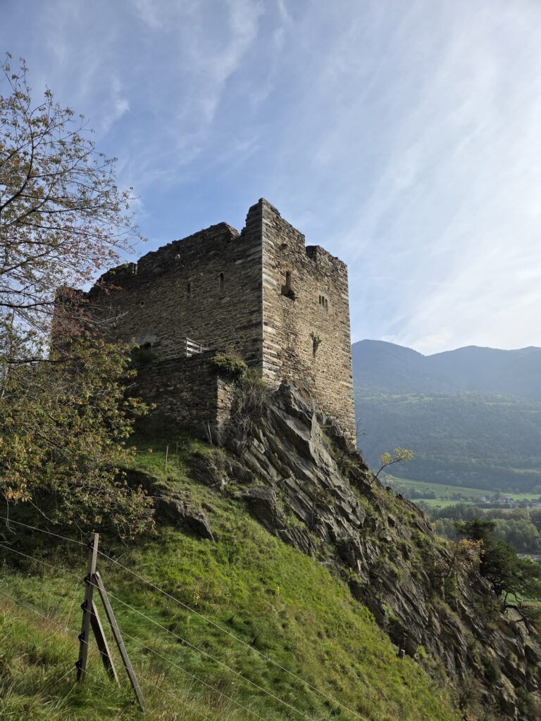
Alt-Haldenstein occupies a small rocky outcrop at about 630 metres above sea level below the Calanda massif. The steep formation allowed only a restricted building area, so the castle was compact and gained additional space chiefly by extending its structures upward. Rubble stone was used throughout the castle, and several horizontal divisions in the surviving walls probably mark successive stages in the enlargement of the buildings, especially the tower.
Ancillary buildings stood at the foot of the rock. Their foundations were buried beneath rock debris until a debris avalanche exposed them, and the foundations of at least one building survive. These lower structures were not protected by a surrounding curtain wall. The original approach climbed a ramp at the northern, mountain-facing foot of the outcrop. The southern gate has almost entirely disappeared, although traces of its masonry and foundation beds cut into the rock preserve parts of its former line. The southern section, including the access route, was largely destroyed in the rock collapse of 1769.
The keep
The five-storey keep, the castle’s principal fortified tower, stood on the highest part of the rock. It was narrow and triangular in plan. Its walls are about 0.6 metres thick on the side facing the palas and reach approximately 2.2 metres elsewhere. Seven narrow light slits admitted limited light through the thick defensive walls.
The entrance was placed high on the fourth storey. A pier-like structure supported a wooden gallery that ran around the north-west corner on projecting beams and provided access to the elevated doorway. A canopy suspended from the wall sheltered the gallery. The keep was too narrow for habitation. It originally ended in a battlemented parapet, while a shallow roof sloping toward the mountain was added later.
The palas and interior arrangements
The palas stood beside the keep and was originally five storeys high, also ending in battlements. It was later raised almost to the height of the keep. Different window forms belonged to different residential rooms. The large openings made those rooms unsuitable for winter occupation until window glass was introduced in the fourteenth century.
Several layers of interior plaster show that the rooms were renewed repeatedly. A staircase beside the keep connected the storeys, and thin wooden partitions divided the individual rooms. The kitchen occupied the ground floor. A cistern, a built reservoir for collecting and storing water, probably supplied the castle from the part of the complex later destroyed by the rock collapse.
The surviving castle is ruinous. Major portions of the southern and eastern sections were lost when the rock gave way, while the remaining masonry stands on a steep formation reached by a narrow, steep route along the mountain.
Nearby sites