Burg Stromberg: A Medieval Hilltop Castle in Germany


Site at a Glance
- Rating
- 4.7
- Popularity
- Low
- Country
- Germany
- Primary era
- Medieval
- External website
- Open
- Eras represented
- Medieval
- Civilizations
- Holy Roman Empire
- Site type
- Military
- Remains
- Castle
On this page12 sections
History
Origins and Episcopal Frontier
Burg Stromberg is the ruin of a medieval hilltop castle in Stromberg, now a district of Oelde, Germany. Its origin predates 1177, and the castle occupied a strategic position on the southeastern frontier of the Bishopric of Münster, an ecclesiastical territory that also functioned as a political jurisdiction ruled by the Bishop of Münster.
Legend attributes the castle’s foundation to Charlemagne around 800, after he established nearby monasteries at Liesborn and Herzfeld and ordered castles to protect them. The connection with Charlemagne’s period, particularly through the monastery at Liesborn, remains a historical tradition rather than a documented foundation date. The castle’s position made it suitable for controlling and defending the eastern edge of the bishopric. It became the only hilltop castle in Münsterland after Cappenberg Castle was converted into a monastery in 1122.
The Stromberg Burgraves
The burgraves of Stromberg first appear in a charter issued in 1177 by Hermann, Bishop of Münster. A burgrave was a castle governor or hereditary castellan whose responsibilities could include the administration and defense of surrounding territory. The charter names Burgrave Othalrich and his wife Gisla. After the death of their son Gottfried I, the castle was granted as a fief to their grandsons Hermann II and Heinrich I, the sons of their daughter Gisla.
Burg Stromberg belonged to the Bishop of Münster but was held from 1177 to 1463 by the Stromberg burgraves of the Rüdenberg family. When the burgrave line ended in 1463, control returned to the bishop. The castle later became the seat of the Stromberg administrative office.
Religious and Later History
The Gothic Church of the Holy Cross stood within the castle and was consecrated in 1344. The Holy Cross of Stromberg was venerated there, adding a religious function to the castle complex’s military and administrative roles. The arms of the Stromberg burgraves, showing three ravens, also appear in the Quaternion Eagle, a heraldic representation of the Holy Roman Empire that displays the arms of imperial estates and territorial rulers.
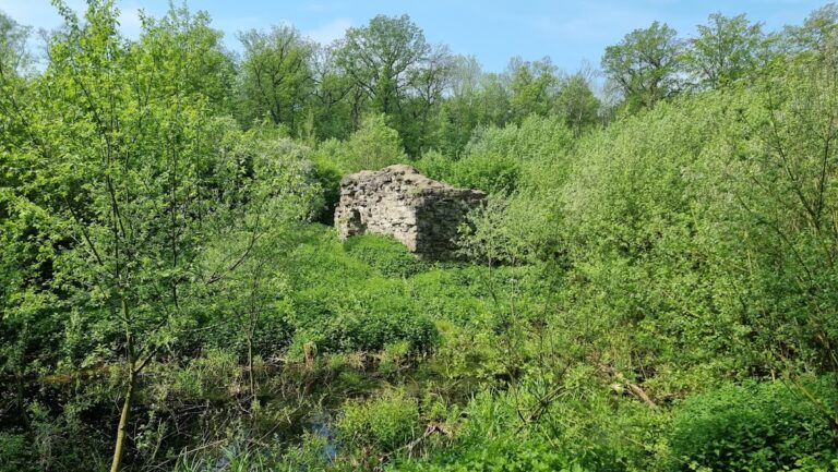
From 1780, Maximilian Franz, Elector and Bishop of Münster, ordered the castle to be dismantled. Substantial ruins of the walls and buildings remain, preserving the physical outline of a site that served the Bishopric of Münster for centuries.
Remains
Enclosure and Defenses
Walls and Natural Slopes
The castle occupies a strategically favorable hill in the Beckum Hills. Its almost triangular enclosure covered approximately 30,000 square metres and was surrounded by a wall about 745 metres long. The highest point, at the Church of the Holy Cross, reaches 154.59 metres above sea level, while the remainder of the complex lies at approximately 151.15 metres.
Steep slopes on the south and west provided natural defenses that were reinforced by thick walls. On the east and north, a double wall and intervening ditches protected the enclosure. Several watchtowers stood along the enclosing walls, and substantial portions of the former walls and buildings survive as ruins.
Entrances and Towers
The approach from present-day Münsterstraße led through a tower positioned in front of the Paulusturm. A drawbridge provided additional protection for the Paulusturm. This entrance system opened onto the first of the castle’s three courtyards.
A second gateway, guarded by two shield houses, led to the courtyard in the southern part of the castle. Shield houses were small defensive structures designed to protect a gateway or another vulnerable entrance. A smaller third courtyard occupied the western side of the southern section and was probably known as the administrative square.
Courtyards and Buildings
Castle Retainers’ Courtyard
The first courtyard was the castle retainers’ courtyard. Castle retainers, or Burgmannen, were members of the castle’s military and administrative personnel. Their residences stood around the courtyards, and the Church of the Holy Cross was the first prominent feature encountered after passing through the main entrance.
The Mallinckrodthaus, on the left side of the castle retainers’ courtyard, still conveys the appearance of these former residential buildings. The church, built in the twelfth century and later consecrated in 1344, remains a principal feature within the castle enclosure.
Burgrave’s Residence
The burgrave’s residence, known as the palas, stood along the southern castle wall. A palas was the principal residential and representative building of a medieval castle. Its position formed part of the southern group of buildings beside the courtyards and defensive structures.
Water Supply and Setting
Several wells supplied water to the castle’s inhabitants. One well between the Paulusturm and the Church of the Holy Cross is approximately 30 metres deep, while the Paulusturm itself is approximately 30 metres high.
The elevated site offers views eastward toward the Paderborn region, the southern Teutoburg Forest, and the Egge Hills, and southward across the Haarstrang toward the Sauerland mountains. These directions correspond to the hill’s strategic landscape setting and help explain the choice of the location for the castle.
Nearby sites