Kavala Fortress: Byzantine and Ottoman Defenses of the Egnatia Road


Site at a Glance
- Rating
- 4.6
- Popularity
- Medium
- Country
- Greece
- Primary era
- Medieval
- Eras represented
- Classical, Medieval
- Civilizations
- Ancient Greek, Byzantine, Ottoman, Roman
- Site type
- Military
- Remains
- Fort
On this page11 sections
History
Kavala Fortress is a fortified complex in Kavala, Greece, whose acropolis defenses began in the fifth century BC under the civilization that established the ancient settlement on the peninsula. Built and repeatedly altered through Byzantine and Ottoman periods, it controlled the important Egnatia road, an ancient route linking the Adriatic region with the Aegean and Constantinople, while also watching the coast and nearby naval movements.
Early and Byzantine Fortifications
The acropolis on the peninsula was fortified from the fifth century BC. Its defenses were later repaired and strengthened under the Roman emperors Julian and Justinian. Justinian, who was associated with extensive imperial rebuilding and fortification projects, oversaw works in the sixth century. Part of the Justinianic wall was rebuilt in 926.
In 1307, during the reign of the Byzantine emperor Andronikos II Palaiologos, who ruled from 1282 to 1328, the fortifications were modified. A wall was constructed from the sea-facing side of the peninsula to the summit of the hill, reinforcing the defensive division of the acropolis.
Ottoman Reconstruction and Military Use
Ottoman and Venetian forces destroyed the Byzantine acropolis of Christoupolis, the Byzantine-era name of the settlement associated with modern Kavala, during the capture and siege of the city in 1391. The Ottomans rebuilt the fortress in 1425. Construction of the inner enclosure began in April and was completed in July of that year. A large rebuilding campaign may instead have taken place under Sultan Selim or Sultan Suleiman during the 1520s and 1530s, although its attribution remains uncertain.
The peninsula was still ruined and uninhabited in 1425, so the fortress was not built to defend an occupied settlement. Its principal purposes were to control and protect the Egnatia road from pirate raids, monitor Venetian naval movements, and counter a possible Venetian attack. The lower side of the hill facing the harbor remained almost undefended for about a century.
Ottoman writers described the fortress as a powerful defensive structure. Hacikhalfa characterized it in 1650, and Evliya Celebi did so in 1667. From the end of the seventeenth century, the acropolis also served as a place of exile and imprisonment. For a long period it functioned as the city’s military and administrative center, and Ibrahim Pasha, a high-ranking Ottoman official or commander, was held there in exile in 1759.
Decline and Later Ownership
The development of firearms exposed weaknesses in the fortress, including the vulnerability of its water supply and the poor positioning of its guns and towers. Between 1880 and 1885, the Ottoman authorities reclassified it as abandoned. The fortress ceased to be guarded and maintained, and deterioration followed. By the late nineteenth century, the roofs of its two towers had collapsed.
At the beginning of the twentieth century, Abbas Hilmi, the khedive, or hereditary ruler, of Egypt under Ottoman suzerainty, bought the fortress from the Ottoman military authorities. He intended to establish an industrial and craft school there, but the plan was never implemented. Occupying forces used the acropolis militarily for the last time during the Second World War. In 1968, the Municipality of Kavala acquired the fortress, which then passed into municipal ownership. It is now used for recreation and cultural activities, including performances in an open-air theatre with 400 seats, and is recognized as an archaeological monument of Greece.
Remains
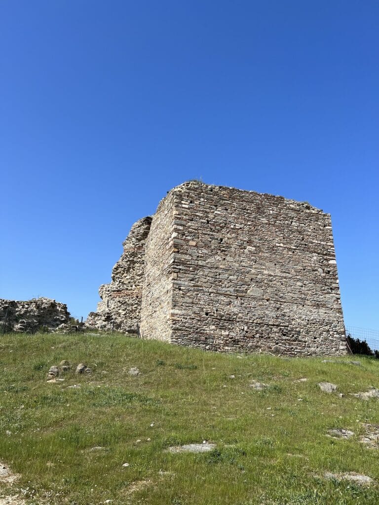
Kavala Fortress occupies the summit of the Panagia Peninsula at the location identified as the acropolis, on the site of the Byzantine acropolis of Christoupolis. The enclosed complex follows the relief and slope of the hill. Its internal area covers 13 hectares and is divided by a transverse wall 449 metres long, which rises to 64 metres above sea level. Local granite forms most of the fortifications, with additions of marble and limestone. The construction was designed to resist attacks with bladed weapons and other hand weapons rather than cannon fire.
Fortified Enclosure
Walls, Towers, and Gates
The enclosure takes advantage of the peninsula’s natural defensive position. Two rectangular towers stand at the corners of the northern wall, while a polygonal tower is placed approximately midway along the eastern curtain wall. A bastion, or projecting defensive platform, occupies the southeastern corner. Four gates provided entry to and exit from the city.
Central Dividing Wall
A circular tower stood on the central dividing wall. It served as the fortress’s final defensive position and stored ammunition, provisions, and water. The tower was later converted into a prison, reflecting the complex’s changing military and administrative uses.
Internal and Supporting Structures
Prison and Guardhouse
The outer wall incorporated a prison measuring 22.80 metres in length and 10.40 metres in width. A guardhouse provided accommodation within the fortress, supporting the personnel responsible for its defense and operation.
Water Reservoir
The fortress also contained a water reservoir. Its presence formed part of the complex’s internal provision system, while the vulnerability of the water supply later contributed to the defensive weaknesses exposed by firearms.
Nearby sites