Miletus: An Ancient Greek City-State in Türkiye

Site at a Glance
- Rating
- 4.6
- Popularity
- Medium
- Country
- Turkey
- Primary era
- Classical
- External website
- Open
- Eras represented
- Bronze Age, Iron Age, Classical, Medieval
- Civilizations
- Ancient Greek, Byzantine, Carian, Mycenaean, Roman
- Site type
- City
On this page33 sections
History
Miletus is an ancient city in Türkiye, near modern Didim, whose Greek city-state developed from a much earlier settlement on the western coast of Anatolia. Occupied from the Neolithic or Chalcolithic period, the site became a major Ionian polis, or independent Greek city-state, and was rebuilt after 479 BC according to a planned Classical-era layout. Its position near the mouth of the Maeander River and the southern shore of the Latmian Gulf supported maritime trade, colonization, political activity, and contact with cultures across the Aegean and Black Sea.
Prehistoric and Bronze Age Miletus
The earliest settlement at Miletus dates from the Neolithic or Chalcolithic period. A city center existed by the fourth millennium BC, and occupation began before the arrival of Greek-speaking populations. Early traditions variously named the first inhabitants as Leleges or Carians. Later foundation stories connected the city with Miletus, a figure associated in different traditions with Minos or Sarpedon of Crete.
Minoan influence reached the settlement during the early second millennium BC. Fresco fragments and material written in Linear A connect Miletus with the wider Aegean world. After a destruction around 1450 BC, Greeks settled at the site, which subsequently became a Mycenaean stronghold, probably between about 1450 and 1100 BC. Hittite records refer to the city as Millawanda or Milawata, while Mycenaean records from Pylos mention people from Miletus. During the Trojan War, Miletus was regarded as a Carian city allied with Troy.
The Bronze Age settlement was destroyed and rebuilt more than once. After the collapse of Bronze Age civilization, the site was apparently burned again, and occupation resumed during the Geometric period. Around 1050 to 1000 BC, Ionian settlers from mainland Greece established control under Neleus, traditionally described as the son of Codrus, the last king of Athens. Tradition says that the newcomers killed the local men and married Carian women. Archaeology supports a major change in the settlement’s history, although a new city may also have been founded beside the earlier one.
The Ionian City and Its Colonies
Miletus became the largest and most influential city of the Ionian League, an association of twelve Greek city-states on the western Anatolian coast and nearby islands. It founded numerous colonies, especially around the Black Sea and the Propontis. Estimates place their number at about 75 or between 80 and 90. Abydos, Lampsacus, Parion, Proconnesus, Cyzicus, Sinope, Amisos, Olbia, and Tomis were among the better-known foundations.
Miletus and the other Ionian cities defeated and destroyed the Carian city of Melia around 730 BC. The Panionion sanctuary was then established at the site and became a meeting place of the Ionian League. During the Lelantine War, conventionally dated to about 720 to 660 BC, Miletus supported Eretria and conducted naval operations in the Aegean. King Leodamas reportedly captured Carystus on Euboea, but opponents later killed him at the sanctuary of Apollo while preparations were being made to celebrate a military victory. The monarchy was abolished, and an office with broad emergency authority, the aisymnetes, replaced it.
After the Lelantine War, written laws and a political settlement helped restore prosperity. From the middle of the seventh century BC, Miletus became a major maritime and colonial power, with trade routes across the Mediterranean and into the Black Sea. The sanctuary of Apollo at Didyma, an oracle where divine guidance was sought and ritually delivered, played an important part in authorizing colonial foundations.
Thrasybulus and the Archaic City
The tyrant Thrasybulus seized power around 616 BC. He encouraged trade and colonization, formed an alliance with Corinth, introduced coinage, and invested heavily in urban improvements. He also preserved Miletus’s independence during a twelve-year war with Lydia, conventionally dated to about 612 to 600 BC, although the chronology of the peace remains uncertain.
Miletus flourished culturally during the sixth century BC. Thales, Anaximander, and Anaximenes were associated with the Milesian school, an early Ionian tradition that sought natural explanations for the structure and origins of the cosmos. The city was also linked with Hecataeus, Cadmus of Miletus, Dionysius, and Aristides.
After Thrasybulus, the tyrants Thoas and Damasenor depended on wealthy landowners and shipowners. Their rule sharpened conflict between elite landowners and poorer producers. A prolonged civil struggle ended through mediation by people from Paros and the creation of a moderate oligarchy. Miletus later acknowledged the authority of Cyrus the Great after the Persian conquest of Lydia in 546 to 547 BC, while retaining substantial internal autonomy. Under Persian rule, Histiaeus became tyrant, and his relative Aristagoras governed during his absence.
Destruction in the Ionian Revolt
Aristagoras’s failed expedition against Naxos helped provoke the Ionian Revolt in 499 BC, an uprising by Greek cities in western Anatolia against Persian rule. Miletus became the revolt’s principal center. Aristagoras led the rebellion, while Hecataeus warned against it and unsuccessfully proposed moving the population temporarily to Leros.
The revolt ended with the Battle of Lade in 494 BC. Persian forces besieged and captured Miletus, destroyed the city, killed much of its population, and deported survivors. Some inhabitants were resettled near the mouth of the Tigris or in Babylonia, while Miletian territory was given to the Carians. Miletus never regained its earlier political and maritime predominance.
Rebuilding and Classical Rule
Rebuilding began after the Greek victory over Persia in 479 BC. The reconstruction followed a planned orthogonal layout associated with Hippodamus of Miletus, whose name became linked with the regular arrangement of streets and urban blocks. Miletus joined the Athenian-led Delian League, an alliance formed after the Persian Wars, from 478 BC. Its government shifted repeatedly between oligarchy and democracy. Athens intervened in local conflicts and helped impose democratic government during the fifth century BC.
Miletus initially supported Athens during the Peloponnesian War, the long conflict between Athens and Sparta and their allies, but revolted in 412 BC. Athenian forces failed to recapture the city in 411 BC. Miletus later became an oligarchy under Spartan influence, and democratic government was subsequently restored.
Persian authority was recognized again through the Peace of Antalcidas in 387 BC, a settlement that confirmed Persian control over Greek cities in Asia Minor. The Carian ruler Mausolus acquired control of Miletus between about 377 and 375 BC without destroying its internal institutions. The relocation of the Carian capital to Halicarnassus nevertheless created a powerful commercial rival.
Alexander the Great captured Miletus in 334 BC after a siege. The city resisted because a Persian fleet was nearby, but Alexander’s forces blocked the harbor and took the city. Part of Miletus was destroyed. Alexander then granted the city freedom and restored democratic government.
Hellenistic and Roman Miletus
After Alexander’s death, Miletus passed among several Successor rulers, including Antigonus I Monophthalmus, Demetrius Poliorcetes, Lysimachus, the Seleucids, and the Ptolemies. Antigonus restored the city’s autonomy in 312 to 313 BC. The Seleucids later restored a democratic constitution under royal supremacy, while Ptolemy II seized the city in 279 BC. Miletus remained under Egyptian control for much of the later third century BC, and Antiochus II removed the tyrant Timarchus around 260 BC.
Miletus supported Rhodes against Philip V of Macedon in 201 BC. It later became associated with Rome during the Roman-Syrian War and entered the province of Asia in 133 BC, while retaining autonomy for a time. Its freedom was withdrawn during the Mithridatic period and restored under Mark Antony in 38 BC.
Roman rule brought renewed prosperity. Pidasa was incorporated through synoecism, the political union of communities, in the second century BC, and Myus was incorporated in the first century BC. Miletus expanded particularly under Trajan. The empress Faustina the Younger supported major construction during the second century AD.
The apostle Paul visited Miletus during the early Christian period. The Acts of the Apostles describes his meeting with elders of the church of Ephesus, while another New Testament passage says that he left Trophimus at Miletus because of illness.
Late Antiquity, Byzantium, and Later Settlement
New city walls were built in AD 262, and the fortifications were rebuilt under Justinian in AD 538. By this period, silting had reduced access to the harbors and contributed to economic decline. The Maeander progressively filled the Latmian Gulf with alluvium, turning Miletus into an inland settlement.
During the Byzantine period, Miletus was first an archbishopric and later a metropolitan bishopric. A small castle was built on the hill beside the city, and the theater was partly reused as a fortified structure. By the later Byzantine period, the settlement had contracted substantially.
Seljuk Turks conquered Miletus in the fourteenth century and used it as a port for trade with Venice. The Ottomans also used it as a harbor in the fifteenth century, but continuing silting eventually led to abandonment. A later settlement called Balat developed on or near the ancient site. An earthquake destroyed it in 1955, after which the settlement was relocated as Yeni-Balat.
Excavation and Preservation
Olivier Rayet conducted the first modern excavations in 1873. German excavations directed by Julius Hülsen and Theodor Wiegand followed between 1899 and 1931. Later campaigns were undertaken by Carl Weickart, Gerhard Kleiner, and Wolfgang Muller-Wiener, followed by excavations organized by Ruhr University Bochum. Wars and other events interrupted the work several times.
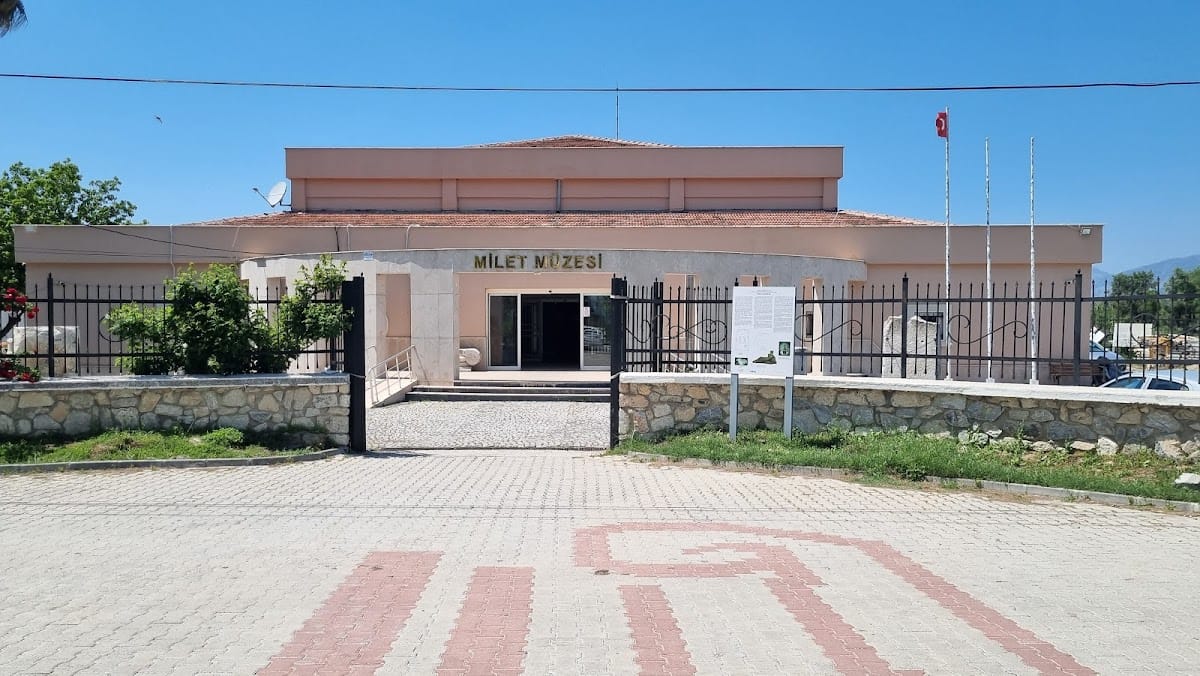
The Market Gate was dismantled during the nineteenth-century excavations, transported piece by piece to Germany, and reassembled in Berlin’s Pergamon Museum. Other finds are held in the Miletus Museum at Didim, which has operated since 1973.
Remains
Miletus originally occupied a small peninsula and, in earlier prehistory, a group of islands at the southern entrance to the Latmian Gulf. Sediment deposited by the Maeander eventually surrounded the peninsula and filled the former gulf and harbors. The ruins now lie about nine to ten kilometers inland. In antiquity, the peninsula measured about 1.8 kilometers from north to south and up to 1.2 kilometers across.
Several defensible hills shaped the city. Humeitepe rose about 26 meters above sea level in the north, Kaletepe, also called Theater Hill, reached about 28 meters to its southwest, and Stadium Hill stood about 10 meters farther southwest. Kalabaktepe, about 57 meters high, lay farther south and served as the old acropolis, the fortified or elevated part of a Greek city. Four natural harbors occupied the peninsula. Theater Harbor lay between Kaletepe and Stadium Hill, Lion Harbor between Humeitepe and Kaletepe, Athena Harbor farther along the western shore, and a fourth harbor on the eastern side. The Tragasaian Islands, especially Lade, protected them.
Defenses and Entrances
City Walls
The earliest settlement stood near the later Temple of Athena, south of Theater Harbor, and was initially unfortified. After destruction during the Late Helladic period, it was rebuilt with defenses. Kalabaktepe was occupied as an acropolis during the Geometric period, while the older area functioned as a harbor settlement. Walls surrounded Kalabaktepe from the Geometric period, and the hill was rebuilt during the reconstruction after 479 BC. It was abandoned as the reduced city ceased to extend that far by about 100 BC.
The lower city walls passed through several poorly understood phases. Late Mycenaean remains near Theater Harbor date from about 1350 to 1050 BC. Archaic walls were built around 650 BC and repaired around 550 BC. New walls were probably constructed around 411 to 402 BC after Persian authorities permitted their construction. Around 200 to 190 BC, a cross-peninsula wall with towers created a new southern boundary and left Kalabaktepe outside. This section was about 500 meters long, with towers placed at roughly 60-meter intervals. It reached about 4 to 5 meters in thickness and 8 to 9.5 meters in height.
The fortifications were repaired in AD 263 during Gothic attacks. In AD 538, Justinian built a smaller circuit around the northern peninsula, including Humeitepe, Kaletepe, and Lion Harbor. A Byzantine fortress was later built on Theater Hill, probably during the ninth or tenth century.
Sacred Gate and Roads
The Sacred Gate was the principal entrance to Miletus and carried the Sacred Way toward Didyma. Its earliest form was about five meters wide and flanked by two towers. It was rebuilt around 200 to 190 BC, with a final major construction phase around AD 100. The Sacred Way extended about 18 kilometers to the sanctuary and oracle of Apollo at Didyma. A Roman road led east toward Assesos, while the Maeander supported limited inland transport by small rafts.
Agoras and Civic Buildings
North Agora
The North Agora, an agora being a principal public square for commerce and civic activity, lay near Lion Harbor and formed the city’s main commercial center. It measured about 50 by 87.5 meters and developed in two main phases between the late Classical and Hellenistic periods, approximately 350 to 160 BC. Two L-shaped stoas, covered colonnades that contained shops and other rooms, enclosed the space. Their Doric columns supported commercial activity around the square. A small Ionic temple with a porch of columns stood at the center of the western side. The eastern side was initially open and was later closed by a wall and shops.
South Agora and Market Gate
The South Agora was built in stages during the Hellenistic period, approximately 280 to 150 BC, and measured about 164 by 194 meters. Its scale made it one of the largest agoras in the Greek world. It may have served as the political agora for official ceremonies. An eastern stoa extended for about 189 meters, while L-shaped stoas bordered the northern, western, and southern sides.
The Market Gate formed the north entrance of the South Agora. Built around AD 120, it was about 29 meters long and 17 meters high, with two stories and three vaulted entrances on the lower level. Composite columns stood below and Corinthian columns above. The gate was dismantled and reconstructed in the Pergamon Museum in Berlin.
Central Square and Civic Council House
A central square between the North and South Agoras was bordered by the Bouleuterion to the west, the Nymphaeum to the east, and the Market Gate to the south. The Sacred Way joined this space, and the Ionic Stoa stood along its eastern side.
The Bouleuterion, the meeting place of the city council, stood between the two agoras. Built around 175 to 164 BC, it may have replaced an earlier building. The complex contained a peristyle court, a courtyard surrounded by columns, entered through a monumental propylon. It measured about 34.8 by 55.9 meters, while the main meeting hall measured about 34.8 by 24.3 meters. Theater-like seating accommodated approximately 1,200 to 1,500 people. Doric, Ionic, and Corinthian elements were used, and a large altar was added to the court during the Roman period.
West Agora
The West Agora, the youngest of Miletus’s principal agoras, was built in the second century BC between Theater Harbor and the Temple of Athena. It measured approximately 191 by 79 meters.
Temples and Sanctuaries
Temple of Athena
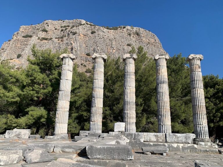
The Temple of Athena occupied a sanctuary used during the Mycenaean and Archaic periods, in the area of the earliest settlement. The Classical temple was built after 479 BC in the Ionic style and was unusually oriented north to south. It measured about 17.2 by 28.2 meters and probably had a pseudodipteral colonnade, an outer row of columns spaced as if a second row had been planned, with eight by fourteen columns. A true double colonnade stood at the entrance porch. The temple contained a pronaos, or entrance porch, and a naos, the principal inner chamber.
Delphinion
The Delphinion was the sanctuary of Apollo Delphinios near Lion Harbor and was connected with the cult at Didyma. Its surviving phase dates from about 340 to 320 BC. The complex included a Doric peristyle court that was later expanded to approximately 50 by 60 meters from an original area about half that size. Stoas were added along the north, east, and south sides during the early Hellenistic period, followed by a western stoa that completed the colonnaded court.
A circular temple was added during the Roman period, and a monumental entrance, or propylon, was added during the later imperial period. The Sacred Way began at the Delphinion and continued to Didyma, where a spring procession proceeded to the Temple of Apollo.
Serapeion and Kalabaktepe Temple
The Serapeion stood west of the South Agora and was dedicated to Zeus Serapis, a deity associated with Helios. Built in the second century AD, it consisted of a porch and an inner chamber. The four-column Composite porch projected before the main room, which measured about 22.5 by 12.5 meters and contained two rows of Ionic columns. A separate temple of Isis may have stood nearby.
A small Ionic temple on Kalabaktepe was built around 525 BC and measured about 6.8 by 8.7 meters. Near the Sacred Gate, the heroon of Neleus, a shrine or monument dedicated to a hero or founder, probably commemorated the traditional founder of the city.
Didyma and the Altar of Poseidon
Didyma was a sanctuary district controlled by Miletus and housed an oracle of Apollo. Its principal monument was the Temple of Apollo, or Didymaion, one of the largest temples of the ancient world. The district also contained temples of Artemis, a theater, and a stadium.
The first Temple of Apollo at Didyma was built in the seventh or sixth century BC. A replacement begun around 550 to 540 BC was destroyed by the Persians in 494 BC. Construction of a third temple began around 331 BC. Its stylobate, the raised platform supporting the columns, measured approximately 51.1 by 109.3 meters. The dipteral temple had an outer colonnade of ten by twenty-one columns and an inner colonnade of eight by nineteen columns surrounding the naos.
The Altar of Poseidon stood at the tip of the Poseidion peninsula, about seven kilometers southwest of Didyma. Built around 575 BC, it consisted of a rectangular altar terrace measuring about 11.1 by 9.5 meters and an eastern sacrificial altar measuring approximately 1.8 by 3 meters.
Theater, Stadium, and Athletic Buildings
Theater
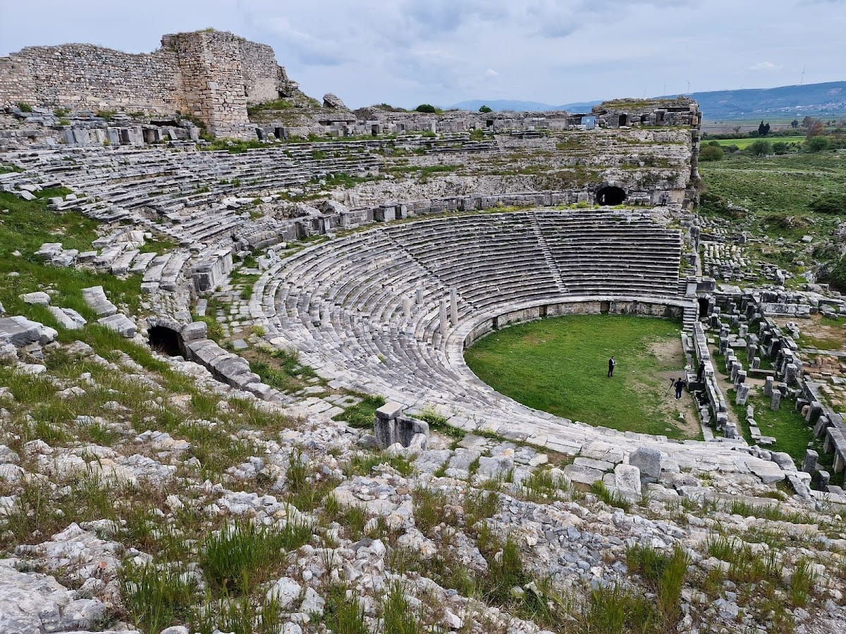
The Theater was built into the southern slope of Theater Hill. It served for performances and as a meeting place for the citizen assembly, and it may also have accommodated the council before construction of the Bouleuterion. Its Hellenistic rebuilding phases date from about 300 to 133 BC, while the surviving remains belong mainly to its final Roman phase.
The theater was about 140 meters wide, with sixty rows of seats. Cross-passages divided the seating into three sections, and stairways divided those sections into five, ten, and twenty sectors. The stage building was about 40 meters wide, originally two stories high and later three stories. Its capacity was approximately 15,000 people. A cave beneath the theater is interpreted as a sacred cave associated with the cult of Asklepios, the god of healing.
Stadium and Gymnasium of Eumenes II
The Stadium lay west of Theater Harbor, south of the theater. It was probably built by Eumenes II around 166 BC, although its close fit with the city plan has led to the possibility that space for it had been reserved in the reconstruction after 479 BC. The track measured approximately 192.3 by 29.6 meters, similar in size to the stadium at Olympia. Remains of the starting-gate system survive, and a western propylon connected the stadium with the Gymnasium of Eumenes II.
The Gymnasium of Eumenes II stood between the West Agora and the stadium near the Temple of Athena. It was aligned with the stadium and connected to it by the monumental entrance.
Gymnasium of Eudemus
The Gymnasium of Eudemus stood east of the North Agora and was built around 200 to 150 BC. Its southern entrance was a propylon. The central palaestra, a facility for athletic training, especially wrestling, measured about 19 by 35 meters and was surrounded by Doric columns. Rooms along the northern side included an ephebeion, a training and teaching room for young men.
Harbors and Roman Baths
Theater Harbor
Theater Harbor occupied the western shore south of the theater and was used from prehistory until late antiquity. The theater, the Stadium and Gymnasium of Eumenes II, and the West Agora stood around it. A Roman aqueduct about two kilometers long brought water from springs in the nearby hills.
Lion Harbor
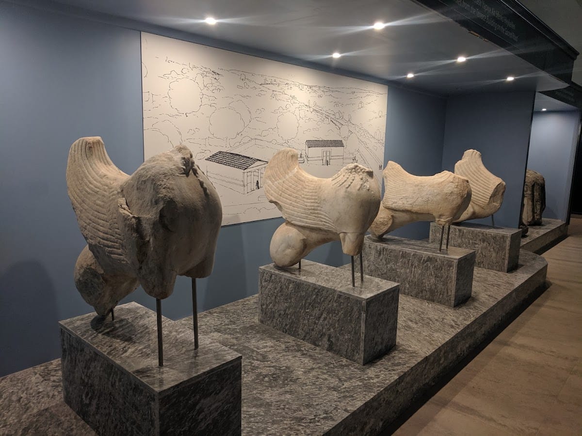
Lion Harbor lay between Humeitepe and Theater Hill and extended deeply into the northern peninsula. It functioned as Miletus’s naval harbor and took its name from two large lion statues placed at its entrance. One survives intact and the other survives in fragments. A 32-meter-long L-shaped Doric stoa with shops and storage rooms stood beside the harbor. Two large Roman monuments, known as the Great and Small Monuments, were later erected at its southwest corner. The North Agora lay nearby.
Faustina Baths
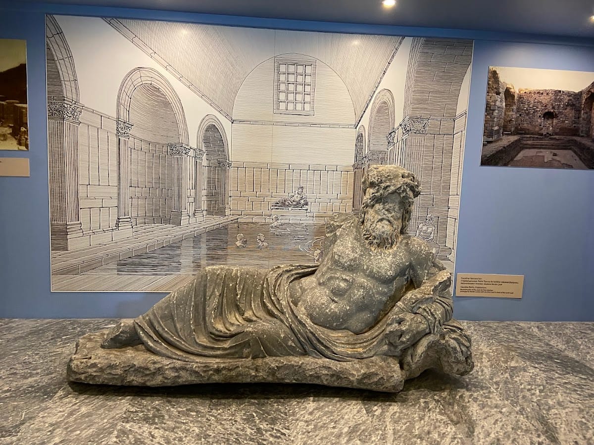
The Faustina Baths stood near Theater Harbor, south of the theater and north of the stadium. Built in the second century AD, they included a western palaestra measuring approximately 62 by 64 meters and an eastern bath building. A basilica-shaped apodyterium, or changing room, about 80 meters long stood beside the palaestra. The complex also contained warm, cold, hot, and sweat rooms, as well as a Room of the Muses associated with the imperial cult. Its remains are among the most conspicuous structures at Miletus.
Capito Baths
The Capito Baths stood between the Delphinion and the Gymnasium of Eudemus, east of the North Agora. Probably built around AD 41 to 54, they were the earliest Roman baths at Miletus. The complex measured approximately 96 by 40 meters. Its western palaestra measured about 39 by 40 meters, while the eastern side contained a three-aisled bath building.
Archaeological Landscape and Collections
Miletus is difficult to view as a complete ancient city because large areas are buried beneath alluvium deposited by the Maeander. The surviving excavated remains include the Market Gate, the major civic and religious buildings, sections of the defensive walls, the harbors, and the theater. Finds from the site are held in the Miletus Museum at Didim, while the Market Gate is reconstructed in Berlin’s Pergamon Museum.