Castle of Dédes: A Medieval Fortress in Hungary


Site at a Glance
- Rating
- 4.6
- Popularity
- Low
- Country
- Hungary
- Primary era
- Medieval
- Eras represented
- Medieval
- Civilizations
- Hungarian
- Site type
- Military
- Remains
- Castle
On this page15 sections
History
Castle of Dédes is a medieval fortress in Hungary, above Dédestapolcsány in the northern Bükk region. It was built in the thirteenth century during the reign of King Béla IV, after the Mongol withdrawal, by Ernye of the Ákos kindred. Ernye was a ban, a senior royal military and administrative official, and a loyal supporter of the king. The site is first mentioned in 1254, while an earlier document from 1247 describes the sale of part of Dédeskő by Markus son of Gregory, James son of Zadur, and Damiano, who sought help from the Miskóc family.
Ákos family and royal conquest
Ernye’s son Stephen later became palatine, the highest-ranking royal official in medieval Hungary. After the death of Andrew III in 1301, which ended the Árpád dynasty in the male line, Stephen did not support Charles Robert’s claim and instead favored the free election of a king. Stephen’s sons were defeated by royal forces at the Battle of Debrecen in 1317 and fled to Dédes Castle.
Dózsa Debreceni, the king’s commander, besieged and captured the fortress. The rebels were sentenced to death, and their property was confiscated. In 1325, Charles I, also known as Charles Robert, rebuilt the castle and appointed a castellan, the official responsible for its administration and defense.
Fifteenth- and sixteenth-century ownership
Queen Barbara pawned Dédes Castle to Stephen Rozgonyi in 1431. King Albert recovered it in 1439 and granted it to the Palóczy family, which retained the property until 1526. Antal Palóczy, the family’s last male member, died at the Battle of Mohács that year. The battle brought a major defeat for the Hungarian kingdom and opened a period of political and territorial conflict.
After 1526, the Dobó and Perényi families disputed ownership. The castle eventually passed to King John, John I of Hungary, a claimant and ruler during the succession struggle that followed Mohács. In 1537, he granted Dédes and its estates to Peter Perényi. Peter’s son, Gábor Perényi, died without a successor, and the property then came into the possession of Boldizsár Erdőhegyi.
Dédes Castle administered and controlled Dédes and the market town of Sajószentpéter, together with Tardona, Nagyvisnyó, Tapolcsány, Mályinka, Szilvásvárad, and Rátótföldje. Its position and associated estates gave it authority over a broad area around the fortress.
The Ottoman siege and destruction
Ottoman forces began besieging Dédes on 1 April 1567 under Hasan Pasha of Temesvár, an Ottoman provincial governor and military commander. The castellan László Kávásy initially led the defense. After his death, István Bárius, also known as Bory, assumed command. The defenders resisted for fifteen days despite the overwhelming Ottoman force, but their supplies dwindled until escape became their only remaining option.
The commander ordered the remaining gunpowder to be placed beneath the castle tower. The defenders then escaped through a concealed tunnel. When Ottoman troops entered the fortress, the powder exploded and killed several hundred soldiers. Hasan Pasha subsequently ordered the surviving parts of the castle to be demolished. Afterward, Dédes was described as a castle ruin.
Modern conservation
In 1967, the hiking section of the Ózd Ironworkers’ Sports Association placed a commemorative plaque on one of the surviving bastions for the four-hundredth anniversary of the destruction. Part of the bastion collapsed in 2010, breaking the plaque. By the early twenty-first century, the ruins had deteriorated severely.
In 2008, the Cultural Heritage Protection Office enclosed the most dangerous bastion with a safety railing and supported its most unstable wall section with pine poles. A later conservation intervention partly rebuilt the collapsed bastion to approximately the wall height visible in the early 2000s and stabilized it with modern binding materials. The ruins lie within Bükk National Park, where rehabilitation work was carried out through a national park program supported by European Union funding. A route with green lookout markings, railings, and steps was established to reduce erosion and improve safety, replacing the former western ascent with an approach from the south along the eastern side of the ruins.
Remains
Ridge-top layout
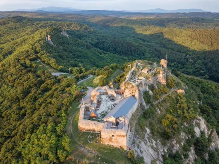
The castle occupies the 597-metre-high, limestone-based Várhegy above the Bán Valley. Its plan follows a north-south axis for about 70 metres. The southern end is approximately 20 metres wide, while the site narrows toward the north to barely 5 metres. The northern and southern parts occupy different levels, giving the remains a stepped arrangement along the ridge.
Northern ridge
The northern half lies on a narrow limestone ridge about 30 metres long and 5 to 6 metres wide. It is roughly 4 metres lower than the southern half. Along the western side, wall debris survives in three sections, generally 1 to 2 metres high. The eastern side is bounded by an almost vertical rock face, which formed a natural defense. Shrubs and trees now cover the area, with masonry fragments lying among the vegetation.
Southern enclosure
The southern half forms a rectangular area about 40 metres long and 20 metres wide, positioned 4 metres above the northern section. Its eastern boundary includes a wall approximately 16 metres long and 3 to 4 metres high. At its northern end, the wall turns at a right angle and continues for another 6 metres. The castle masonry was built from locally available limestone bonded with mortar.
Walls and internal features
Southwestern corner wall
The largest freestanding corner wall stands at the southwestern corner of the southern enclosure. Its western side measures 8 metres, while its southern section extends for 2 metres. The wall survives to about 6 metres in height. An opening for a window remains visible, as do the positions of beams that once separated internal levels. The structure is highly unstable, particularly at its base.
Possible cistern
Near the centre of the southern area is a regular square depression about 4 metres wide and 3.5 metres deep. Parts of its interior are lined with fired red brick. Because sections of that lining have collapsed, the feature is probably the castle’s cistern, a built reservoir for storing water.
Bastion remains
Corner walls belonging to a bastion remain visible, together with other sections of the castle wall emerging from the vegetation. These fragments are generally in poor condition. The bastion’s surviving fabric also preserves the effects of later collapse and stabilization, including the partial restoration carried out after the ruins had become especially unstable.
Defensive landscape
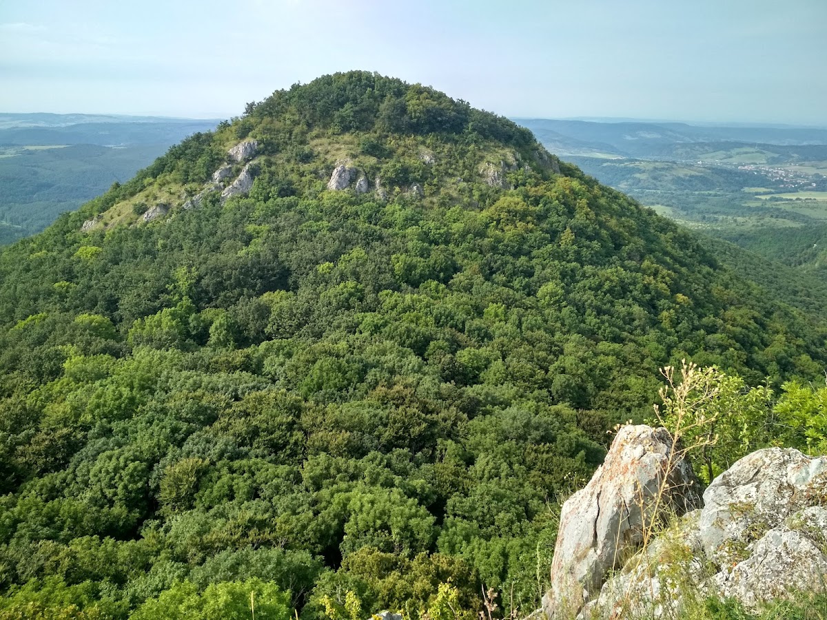
The northern and eastern sides of Várhegy are protected by very steep limestone cliffs, which are locally almost vertical. The southern and western sides descend more gradually toward the valley and were easier to approach. The wall sections on those sides were probably thicker and stronger. Cuts or ditches were made into the hillside, and similar lower cuts may also have served as an access route.
About 10 metres below castle level, a horizontal terrace runs along parts of the southern and western slopes. It may once have been a ditch that was later filled with fallen masonry. This feature, together with the hillside cuts and surviving walls, shows how the fortress combined natural cliffs with constructed defenses.
Kisvár
The smaller limestone crag called Kisvár rises beside Várhegy to 594 metres. It formed part of the castle complex. A small citadel may have stood on the crag and been connected with the main castle by ramparts, although this interpretation remains probable rather than certain.