Vulci: An Etruscan City and Roman Municipality in Italy
Site at a Glance
- Popularity
- High
- Country
- Italy
- Primary era
- Classical
- Eras represented
- Bronze Age, Iron Age, Classical
- Civilizations
- Etruscan, Roman
- Site type
- Settlement
- Remains
- City
On this page32 sections
History
Vulci was an Etruscan city, later a Roman municipality, on a plateau beside the Fiora River in Italy. People lived on the plateau from the end of the Bronze Age, and archaeological evidence traces continued occupation into the Early Iron Age.
From early settlement to Etruscan city
During the tenth century BC, communities left numerous Bronze Age villages and gathered in a large settlement on the plateau. In the second half of the eighth century BC, a bank of earth and ditch blocked the saddle linking Pozzatella with the main plateau. This work appears to have placed Pozzatella at the settlement’s edge, perhaps in a craft-related role, and established a western boundary.
Vulci belonged to the traditional twelve peoples of Etruria, a political and religious association later known as the Etruscan League. Metalworking and exchange helped support its growth. A high-status tomb at Cavalupo, dating to 850–800 BC, contains evidence of contact with Sardinia. Trade and imported goods increased during the eighth century BC, while Greek residents and craftspeople contributed to the production and exchange of fine pottery, bronze, and gold in the seventh century.
Wealth, trade, and fifth-century crisis
Vulci’s influence and wealth reached a high point in the sixth century BC. Its territory included Orbetello, Saturnia, Sovana, Castro, Pitigliano, and Marsiliana. The city imported Greek pottery from the region of Athens, eastern luxury goods, and jewellery, while exporting pottery, bronze, and wine around the Mediterranean. Its commercial routes made use of a landing on the Fiora and, as trade developed, the coastal port of Regisvilla, also called Regae.
Craft production and exchange continued into the late sixth and early fifth centuries BC. Workshops of the vase painter known as the Micali Painter became prominent late in the sixth century. Wine from Vulci reached trading centres on the Gulf of Lion, and amphorae made in the lower Albegna valley have been found in southern France and Catalonia.
In the fifth century BC, the plateau’s population declined, wine exports fell, and imports of Attic pottery ceased. The causes are debated: the changes have been linked both to political and social shifts in southern Etruria and to the Etruscan naval defeat at Cumae in 474 BC, after which trade may have turned toward Adriatic ports. A recovery based on farming and local production is proposed for around the middle of the fourth century BC.
Political traditions, rebuilding, and Roman conquest
Etruscan tradition connected Vulci with early Rome. Servius Tullius, a king in Roman tradition, and the legendary brothers Caile and Avle Vibenna were associated with the city. Their names and images appear in the François Tomb. The emperor Claudius also linked Mastarna, a companion of the brothers, with Servius Tullius.
In the second half of the fourth century BC, Vulci undertook extensive building and defensive work. Its aristocracy also commissioned the François Tomb in the third quarter of the century. Its painted program celebrated the local nobleman Vel Saties and earlier Vulcian heroes, expressing political and moral themes.
Vulci resisted Rome during the Roman-Etruscan wars. Rome defeated Etruscan forces at Sentinum in 295 BC, took Roselle in 294 BC, and won at Lake Vadimo in 283 BC. Vulci continued to resist until the Roman consul Tiberius Coruncanius triumphed over its people in 280 BC. Rome took coastal territory, weakening the city’s power. Cosa was founded within Vulcian territory in 273 BC, and the Etruscan League broke apart during the wars.
Roman municipality and late antique change
After the Social War of 91–88 BC, fought largely over Roman citizenship, Vulci became a Roman municipality, a community incorporated into the Roman state with local civic institutions. It was enrolled in the Sabatina tribe, a Roman citizen voting division, and governed by a board of four local magistrates. Roman colonies and roads progressively reduced its territory. The Via Aurelia was built through the city in 241 BC, and the Via Clodia ran inland, yet Vulci retained a viable economy into the age of Augustus, Rome’s first emperor.
Renewal associated with Augustan policy, from the late first century BC into the early first century AD, included large residences and an arch provided for in the will of the senator Publius Sulpicius Mundus. A surviving milestone gives the distance to Rome as 70 Roman miles. Dedications to the emperors Vespasian in AD 73 and Domitian soon afterward indicate continued activity under the Flavian dynasty, which ruled from AD 69 to 96.
The sanctuary of Mithras, a god worshipped in a Roman mystery religion, remained in use into the late Roman period. It was devastated in the last quarter of the fourth century AD. Fire traces, broken sculptures, and the deliberate-looking dispersal of furnishings have been interpreted as evidence that Christians from the city may have destroyed it. A Christian catacomb was identified on the southern slopes of the Osteria in 1834.
A small cemetery developed beside the aqueduct from at least the second half of the third century AD. After a residential complex later called the Domus of the Cryptoporticus was abandoned, isolated burials were placed there between the sixth and eighth centuries. The inhabited area was gradually deserted in the early Middle Ages, probably as coastal marshes formed and malaria spread. Abandonment appears to have been complete by the eighth century, after which Vulci became an episcopal see, the seat of a bishop.
Rediscovery and archaeological investigation
Antiquarian investigations began in the late eighteenth century. Architect Francesco Prada led campaigns in the city and northern cemeteries from 1776 to 1778, and Cardinal Pallotta sponsored work near Ponte della Badia in 1783. In 1778, historian Francesco Antonio Turriozzi proposed identifying the site as ancient Vulci. Excavations from 1835 to 1837 settled the dispute when an inscription naming the council and people of Vulci was found.
Large excavations began in the nineteenth century, including work launched by Luciano Bonaparte at Doganella del Ponte in 1828. Investigations by Vincenzo Campanari, Melchiade Fossati, the Candelori brothers, and Agostino Feoli followed in 1828–29. Antiquarian practices often separated grave goods from their burial contexts, and many objects left Italy, some through illicit removal. The Campanari family organized a London exhibition of reconstructed tombs in 1837. Later discoveries included the Tomb of Isis in 1839 and the painted Saties Tomb, found by Alessandro François in 1857.
Stéphane Gsell’s 1889 excavations, which brought 136 tombs to light, were among the first at Vulci to use scientific methods. Work resumed after a hydroelectric canal damaged the site in 1918–19, followed by campaigns directed by Raniero Mengarelli from 1928 to 1934. Land-reclamation work in the early 1950s transformed the surrounding area and coincided with a rise in illicit digging. Geophysical surveys and urban excavations began in the mid-1950s, and research since the 1990s has combined archival study, field survey, aerial photography, targeted excavation, and conservation. Excavations in the Osteria cemetery in 2011–13 clarified funerary practices from the early seventh to early fifth centuries BC; preventive work also identified a small burial ground at Mezzagnone in 2009.
Remains
Vulci occupied a plateau of volcanic rock measuring 126 hectares on the Fiora’s right bank, about 70 metres above sea level and roughly 10 kilometres from the Tyrrhenian coast. The Fontanile and Pian di Voce ravines bound it to the north and south. The settlement included the area known as La Città, a citadel area, and Pozzatella, which connected to the main plateau by a saddle. Local materials shaped both construction and craft production: soft volcanic tufa and volcanic ash were used in building, easily cut rock for tombs and underground spaces, lava for road paving, travertine came from Canino, and clay served pottery-making.
Cemeteries surrounded the city, with burial grounds to the north at Osteria, Casal di Lanza, Poggio Mengarelli, Marrucatello, and Doganella del Ponte, and to the east at Ponte Rotto, Mandrione di Cavalupo, and Polledrara. Poggio Maremma and Campomorto were connected with settlements peripheral to the early urban centre. These cemeteries contain evidence of changing funerary practice across the city’s occupation, from early graves cut as shafts or pits to chamber tombs, family monuments, cremation burials, and Roman graves with inscribed markers.
Walls, streets, and river crossing
City walls and gates
A circuit of squared stone masonry, about 6.5 kilometres long, enclosed the plateau in the second half of the fourth century BC. At least five gates served routes into the surrounding territory: the North, West, South, Southeast, and East Gates. Three have been exposed, and investigations have suggested three further possible entrances. The defenses were extensively repaired and rebuilt in the early third century BC. At the North Gate, the entrance was converted to a chambered form and strengthened with massive flanking walls. The West Gate had the heaviest defenses, including a second wall with a checkerboard pattern, substantial earthworks, and a triangular projecting platform that blocked a direct assault.
Lower defensive circuit
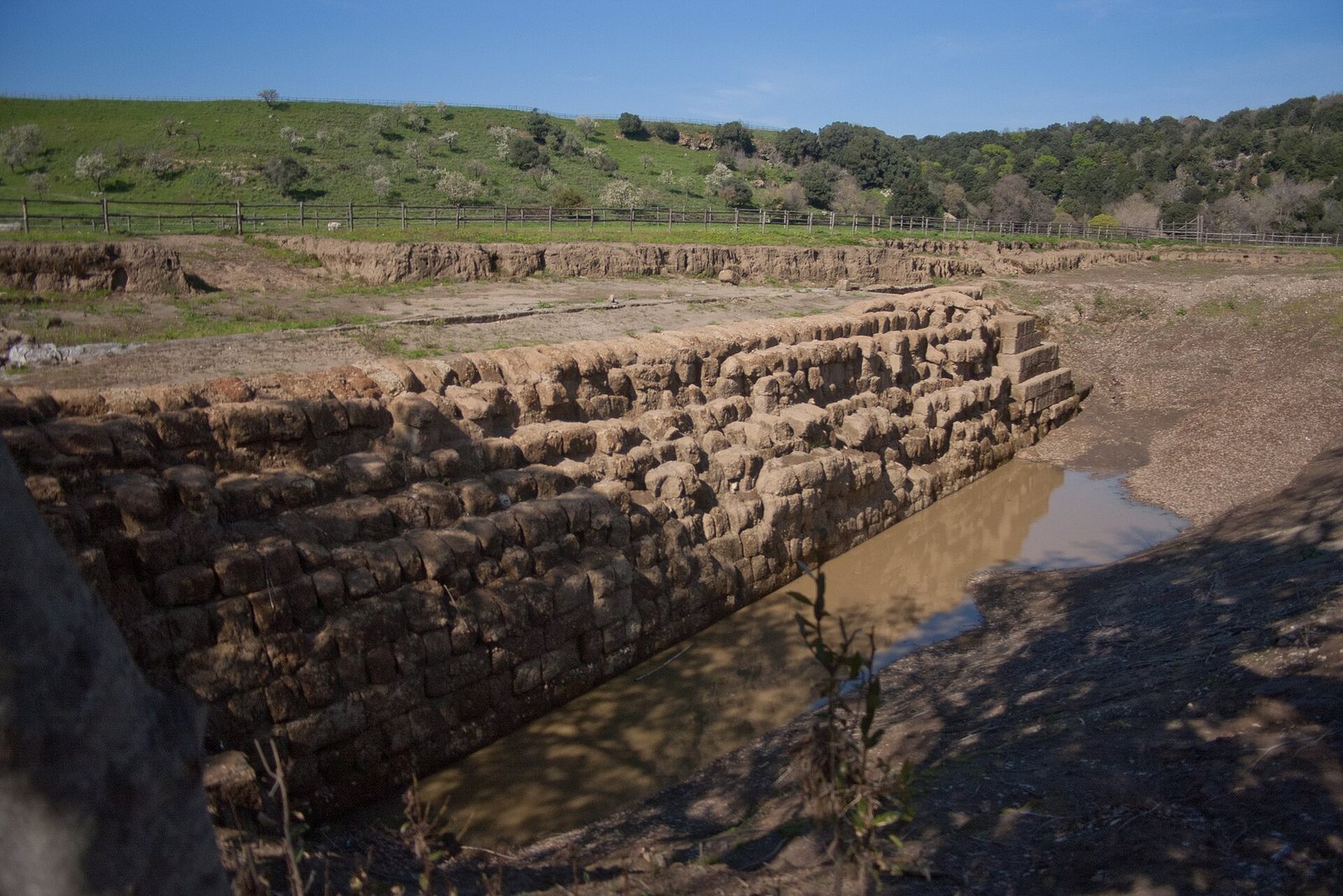
Near the Fiora’s right bank, two stretches of squared-masonry wall, each more than three metres thick, formed part of another defensive circuit. A double-arched gate within it was once roofed. Together, these works protected the plateau and a broad area of the valley that supported production and commerce.
Roads and bridge
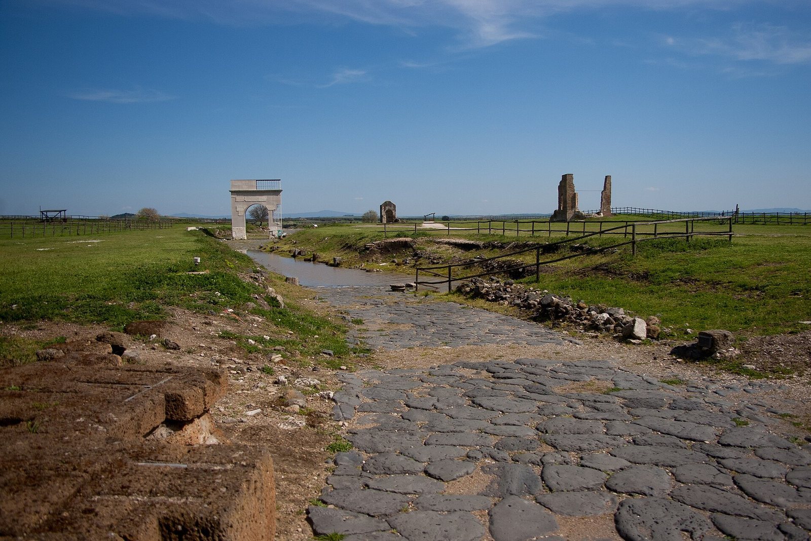
The principal east-west street crossed a main north-south road on the plateau. The east-west route, often called the Decumanus, began at the West Gate and was paved with volcanic stone. A long-distance route used in prehistoric times entered from the northwest, followed this street, then continued through the eastern gates toward Regisvilla. Routes from the North Gate crossed the Osteria cemetery toward settlements to the northwest and northeast. A milestone records the distance to Rome as 70 Roman miles.
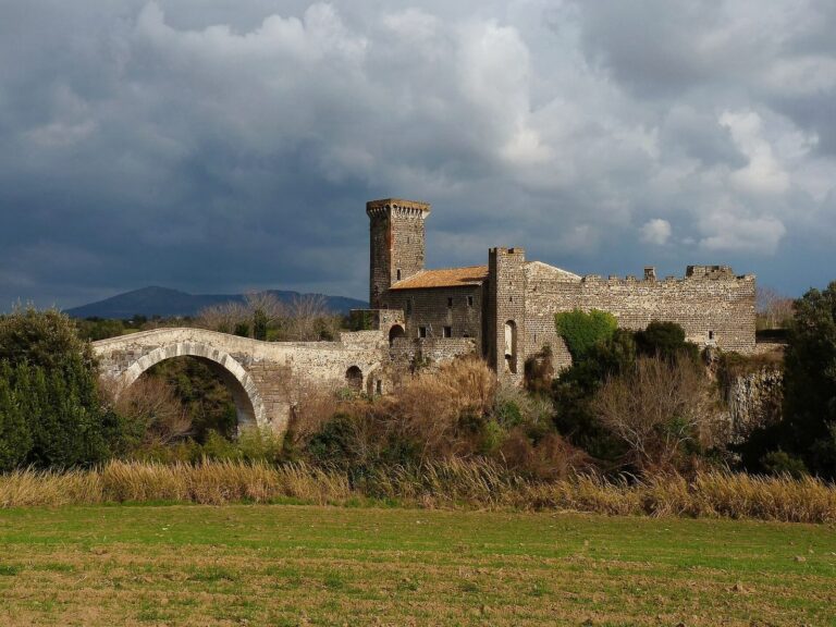
A bridge at Ponte dell’Abbadia carried a road across the Fiora on the site of an earlier Etruscan bridge. The Roman structure was originally about 85 metres long, with five arches and four concrete piers faced in travertine. Remains of the piers rise from the water, while tufa supports are thought to belong to the earlier bridge. The bridge stood about 30 metres above the stream, and its principal arch spanned approximately 20 metres.
Aqueduct
An aqueduct crossed the river as part of the bridge and continued for about 1.5 kilometres toward Vulci. A substantial length survives in front of the West Gate. After the aqueduct fell into disrepair, overflowing water formed a curtain of stalactites on the bridge. Water still flows from the aqueduct into the gardens of the adjoining Castello dell’Abbadia.
Temples and public buildings
Great Temple
The Great Temple stood beside the principal east-west street and was among the large religious buildings of Etruria’s early period. Its podium measures about 36.4 by 24.55 metres; the platform measures 43.5 by 28.5 metres and reaches 49.85 metres with its stepped projection. A colonnade ran around all four sides, with four extra columns at the front and a central staircase. Architectural terracottas date its earliest phase to around 500 BC. Another building phase followed around the middle of the fourth century BC, and it was radically rebuilt in the Imperial period, when wooden upper parts gave way to travertine and concrete construction. Fallen architectural pieces remain around the building, including a fragment of an inscribed architrave.
Shrines and votive deposits
The Shrine of Hercules near the East Gate was founded in the late fourth century BC and had a later phase from the second half of the first to the early second century AD. Outside the western side of the North Gate, a votive ditch contains offerings associated with a fertility cult from the Hellenistic period to the end of the first century AD. Tombs were cut into the nearby rocky bank, beside a structure that remains under investigation. A separate deposit at the North Gate, dating from the early second to the first century BC, has strong associations with Dionysus and his religious traditions.
Forum arch and other urban buildings
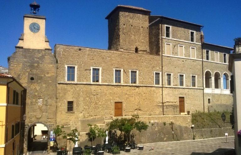
The triumphal arch dedicated to Publius Sulpicius Mundus stood on the main east-west street at the western side of the forum. Its foundations were found in 2003, and surviving fragments allowed the arch to be reconstructed; its long dedicatory inscription identifies the senator. Other urban remains include the so-called Small Basilica, a brick building with a rectangular plan and rounded end provisionally dated to the second century AD, commercial rooms at the main-road junction, and a late antique residence known as the House of the Fisherman. A further rectangular building south of the main street, with a small rounded recess at one end, is thought to have been a late Roman civic hall. Its walls combine net-pattern and irregular stonework set in mortar.
Houses and cult buildings
Domus of the Cryptoporticus
The Domus of the Cryptoporticus, a private Roman house named for its partly underground vaulted gallery, occupied the central-northern part of the city, north of the main east-west street. Its earliest phase dates to the late second or early first century BC. The house was arranged around two central reception spaces and a columned courtyard, with baths and an extensive underground area. A lead water pipe from the bath sector bears the name Marcus Vinicius, probably the owner.
The main entrance opened into a reception hall surrounded by bedrooms and living or dining rooms. A second entrance led to a courtyard with a central fountain, probably created from a smaller lobby in the late first century AD. Beyond it were a main lobby and a rectangular courtyard surrounded on all four sides by columns. Stairs at the courtyard’s northeast corner led to an upper floor that has not survived. A floor mosaic from the first phase remains, as do mosaics from the Augustan period in two rooms opening onto a porch. The porch faced a water feature with a pool and rounded end, probably built in the Imperial period.
The northwestern bath suite was reduced from four rooms to three during Augustan restructuring. It comprised a changing room, a heated-air room, and a hot-water bath. Its intact mosaic floors rested on brick pillars that allowed hot air to circulate beneath them. Service spaces immediately south of the baths connected to the main street by a narrow private road.
A corridor east of the columned courtyard led into the underground gallery, where 18 windows at garden level provided light and ventilation. The corridor retains a well-preserved barrel-shaped vault. The underground rooms were used chiefly to store wine and oil. Buildings beside the house’s northwest side, probably dating to the Hellenistic period, include drains and floors of brick, tile, and local stone; their precise dates and uses are uncertain. The residence was renovated repeatedly under Augustus, altered again between the Flavian and Hadrianic periods, partly reused in late antiquity, and eventually abandoned and used for burials.
Mithras sanctuary
The sanctuary of Mithras adjoined the east side of the house. It had a rectangular plan and two raised platforms supported by six small vaulted chambers, an arrangement that may have referred to stages of initiation. Its cult sculptures date to the first half of the third century AD.
Cemeteries and tombs
Funerary forms and sculpture
Vulci’s burial grounds preserve a range of tomb types. Early Iron Age graves include shafts and pits; later Orientalizing and Archaic burials include deep pits and chambers with open-air vestibules. Monumental family tombs developed in the Late Classical and Hellenistic periods, alongside cremations placed directly in pits. Roman cremation burials sometimes carried inscribed markers. From the Middle Orientalizing period into the early Archaic period, family tombs were grouped around the monument of a prominent individual. Open spaces between these groups have been interpreted as places for funerary ceremonies and cult.
Vulci was also a centre for funerary sculpture carved from nenfro, a local volcanic stone. Sphinxes, lions, and carved capitals decorated burial mounds and tomb fronts. The tombs around Ponte Rotto include those of the Tute, also called the Sarcophagi; the Tarna, or Bulls; the Tetnie, or Two Entrances; the Inscriptions, belonging to the Pruslna family; the Dolphin; and the François. Founded between the mid-fourth and early third centuries BC and used over generations, several have chambers grouped around a central atrium. Their unfinished fronts were shaped with architectural details and sculpture.
Early elite tombs
The Tomb of the Sardinian Bronzes at Cavalupo dates to 850–800 BC and held the cremated remains of two high-status women. Its grave goods included a bronze warrior statue, now in the National Etruscan Museum at Villa Giulia. The intact Tomb of the Bronze Chariot, found in the Osteria cemetery in 1965, dates to about 680–670 BC. Its objects include locally made bronze banquet equipment and two statues assembled from multiple materials. One statue was probably intended for the ceremonial chariot that gives the tomb its name.
Osteria tombs
Large tombs of the Middle and Late Orientalizing periods at Osteria include the Tomb of the Carved Ceilings, whose architectural decoration drew on examples from Caere, and the Tomb of the Bearded Sphinx Painter. The later Tumulo dei Guerrieri, or Mound of the Warriors, contains a principal tomb dated to the late sixth or early fifth century BC. Its grave goods include a tripod, bronze amphora, and helmet. Tomb XLVII, also known as the Warrior’s Tomb, held equipment identifying the deceased as a heavily armed infantryman.
Direct cremations and the Micali Painter
Three direct-cremation burials in pits date to the late sixth and early fifth centuries BC, two at Mezzagnone and one at Osteria. One burial contained an amphora and water jar painted by the Micali Painter, as well as a seated nude youth in terracotta, about half life-size. The figure is attributed to a workshop at Caere and dates to about 500–490 BC.
François Tomb
The large underground François Tomb was built for the aristocracy in the third quarter of the fourth century BC. Its painted scenes draw on Greek and Etruscan myths and include the political and moral celebration of Vel Saties and earlier Vulcian heroes. The frescoes are now held at the private Villa Albani museum in Rome.
Cuccumella and the Tomb of the Silver Hands
Cuccumella is a large burial mound in Vulci’s eastern cemetery, described as the largest in Etruria. It contains two funerary complexes and retains two marker towers on its summit, one shaped like a truncated pyramid and the other like a truncated cone. Work in 2003–06 restored its original configuration and established that a third tomb previously proposed for the mound did not exist.
The C1 mound, also called the Tomb of the Silver Hands, was revealed by excavations in 2011–13. Its name comes from silver hands belonging to a statue made of multiple materials, buried beside a high-status woman with rich jewellery. The main chamber was in use by the second quarter of the seventh century BC. About a generation later, two side chambers were added and the tomb was enlarged into a burial mound.
Tomb of the Sphinx
The B14 Tomb, or Tomb of the Sphinx, was used from about 640–630 to 580–570 BC by people of very high status. An entrance passage 26.5 metres long leads to an open-air vestibule with three doorways. The central doorway opens into a four-sided atrium, with three chambers arranged in a cross. A similarly prestigious plan is known at Caere.
Other notable burials
The Tomb of Isis at Polledrara yielded a rich collection of grave goods, most of which are now in the British Museum. Paintings from the Hellenistic Tomb of the Bell-Ringers are preserved in the Archaeological Museum of Florence. In 1845, a richly bronze-clad chariot was recovered from the Fiora plain below Ponte Rotto. It had been buried with four horses yoked on each side of its pole and the skulls of two dogs. A nearby funerary shrine yielded terracotta objects associated with Dionysus, dating to the middle of the third century BC.
Sanctuaries and settlements beyond the plateau
Fontanile di Legnisina
The extra-urban sanctuary at Fontanile di Legnisina, on the northwestern edge of Polledrara, was identified in 1984 and excavated from 1985 to 1987. Its temple to Uni, an Etruscan goddess commonly associated with Juno, was established in the first half of the fifth century BC. The podium was substantially rebuilt in the fourth to third centuries BC, and the sanctuary remained in use until the first century AD. The complex also included a large enclosure with an altar and a rich group of offerings. Two dedications show that Vei, an Etruscan goddess associated with agriculture and fertility, was worshipped there as well.
Regisvilla
Vulci’s coastal outlet, Regisvilla, lay at Le Murelle, about three miles from the mouth of the Fiora. The remains include at least two buildings of Late Archaic and Classical date, foundations arranged on a regular grid, transport vessels of local and imported origin, and black- and red-figure pottery.
Healing sanctuary
A large group of offerings found on the northeastern slopes of the settlement dates from the late fourth to the first century BC and is associated with healing deities. The sanctuary from which the objects came is thought to have stood on the plateau above.