Wakamiya Ōji: Kamakura’s Historic Shrine Avenue
Site at a Glance
- Popularity
- High
- Country
- Japan
- Primary era
- Medieval
- Eras represented
- Medieval, Early Modern, Modern
- Civilizations
- Japanese, Kamakura shogunate, Later Hōjō, Tokugawa
- Site type
- Infrastructure
- Remains
- Road
On this page16 sections
History
Wakamiya Ōji is a medieval avenue in Kamakura, Japan, built by Minamoto no Yoritomo in 1182 as an axis for his military government and an approach to Tsurugaoka Hachiman-gū. Yoritomo had entered Kamakura in 1180 and made it his base, partly because mountains protected three sides of the settlement while the sea lay to the south. He moved the shrine from near Yuigahama to the foot of the northern hills, then laid out the avenue toward the coast.
Yoritomo modeled the route on Suzaku Ōji, the principal north–south avenue of Kyoto’s ancient capital. Its name means Young Prince Avenue, referring to Yoritomo and Hōjō Masako’s first son, Yoriie, who later became shogun. The project was also a prayer for Masako’s safe delivery. Yoritomo directed the work, with leaders and samurai carrying earth and stone for the approach. A large gate at the seaside end, known as the Great Beach Gate, or Hama no Ōtorii, was first erected in 1180.
The avenue in the Kamakura shogunate
During the Kamakura shogunate, Japan’s medieval military government, Wakamiya Ōji served as a sacred ceremonial route. Ordinary people were generally excluded. Shoguns used it for pilgrimages to shrines in Izu and Hakone, official visits by dignitaries, and other ceremonies. Before setting out for the shrines, a shogun descended the avenue to purify himself at the sacred beach. Hachiman, the deity honored at Tsurugaoka Hachiman-gū, was understood as a protector, and the seaside gate linked the avenue, the shrine’s deity, and the sea. A ceremony to calm the wind was held there periodically.
The route also witnessed political events. In May 1185, after the Minamoto victory at Dan-no-ura, the decisive naval battle of the Genpei War, the captured Taira leader Munemori and his son were brought into Kamakura along Wakamiya Ōji. The medieval chronicle Azuma Kagami describes people lining the road to watch, an unusual public presence on a route normally closed to them. In 1205, Hōjō Tokimasa’s forces killed Hatakeyama Shigeyasu at his residence after Tokimasa’s son-in-law, Hiraga Tomomasa, spoke against the Hatakeyama family. Tokimasa had also resented Shigeyasu’s father, Shigetada, for trying to protect the former shogun Yoriie. The following day, Shigetada was lured to Futamatagawa and killed on the order of the shogun Sanetomo.
A tradition associated with the avenue concerns the Buddhist monk Nichiren. In 1271, while under arrest and being taken from Nagoe toward execution at Tatsunokuchi, he is said to have turned toward Tsurugaoka Hachiman-gū and called on Hachiman to give a sign in support of Buddhism.
Wakamiya Ōji was also part of Kamakura’s defenses and social order. The Kamakura Kaidō, a network of roads linking the city with the surrounding region, converged at the shrine. Three main routes began at its gate, serving shogunal travel and the movement of troops during internal conflicts. Their exact courses remain debated. In a commonly accepted reconstruction, Kami no Michi, the upper route, passed Kewaizaka Pass and continued through places including Susaki, Watauchi, Iida, Seya, and Fuchū to Usui Pass. From there, branches led toward present-day Nagano, Gunma, and Tokyo. Naka no Michi, the middle route, went by Kobukurozaka Pass and Yamanouchi toward Nakayama, where it joined the upper route. Shimo no Michi, the lower route, branched from the middle route before Tsurumi and continued through Koga and Yūki to Utsunomiya. For unclear reasons, Azuma Kagami appears to call the commonly reconstructed upper route Shimo no Michi.
Government officials and powerful households were concentrated in Komachi, east of the avenue. The shogun’s seat was first called Utsunomiya Bakufu and later Wakamiya Ōji Bakufu, using bakufu for a shogun-led government. Building entrances generally faced away from the avenue unless a property belonged to the Hōjō or the shogunate; houses of ill repute were an exception. Residents west of the road generally held lower social standing, and status declined farther south toward Geba, where a pleasure quarter stood.
Medieval names and the seaside gate
The avenue’s name changed over time. Although Azuma Kagami uses Wakamiya Ōji, medieval residents may more often have called it Wakamiya Kōji. In the Muromachi period, later than the Kamakura shogunate, names included Nanadō Kōji, Nanadō Kōrō, Sendō Kōji, and Sendōdan. Nanadō referred to a week of religious observances during which the Kantō kubō, a regional military representative, circled the seaside gate seven times. Sendō referred to praying a thousand times along the avenue. Each February, the Kantō kubō spent a week meditating at the shrine and made seven circuits of the gate.
Storm damage led to the replacement of the seaside gate in 1215. An earthquake and tsunami destroyed that gate and its shrine in 1241. In 1535, the cleric Gyoku’un of An’yō-in began rebuilding it after a dream in which he was asked to restore the gate. He brought building materials by sea from Kazusa Province. The gate remained an important focus of religious observance and a marker of the avenue’s connection with the shore.
Damage, change, and later recognition
Earthquake and flood damage in 1495 was followed by the gradual removal, during the Edo period of Tokugawa rule, of the avenue’s southern section between the seaside gate and Geba. Flooding in 1534 forced pilgrims and other pedestrians to take a detour. A man who entered the priesthood carried earth and stones for repairs and raised funds to fix Geba’s bridge. The central path was shortened again in 1878 to make way for the Yokosuka Line. Geba was a place where riders dismounted before approaching the shrine. Of three bridge crossings marked for dismounting, only the name Shimo no Geba, meaning Lower Geba, endured. The Azuma Kagami describes the change there from a wealthy ceremonial approach to a busy pleasure quarter, while old stories also recall battles at the crossing.
In 1864, two years after the Namamugi incident, an attack on British travelers in Japan, samurai killed Major Baldwin and Lieutenant Bird of the British garrison in Yokohama near Geba. Three men were arrested and executed; their leader’s head was displayed publicly in Yokohama. Baldwin and Bird were buried in the city’s Foreign Cemetery. Wakamiya Ōji is now a nationally designated Historic Site. It was selected for Japan’s 100 Best Roads in 1986 and became part of the Japan Heritage program in 2016.
Remains
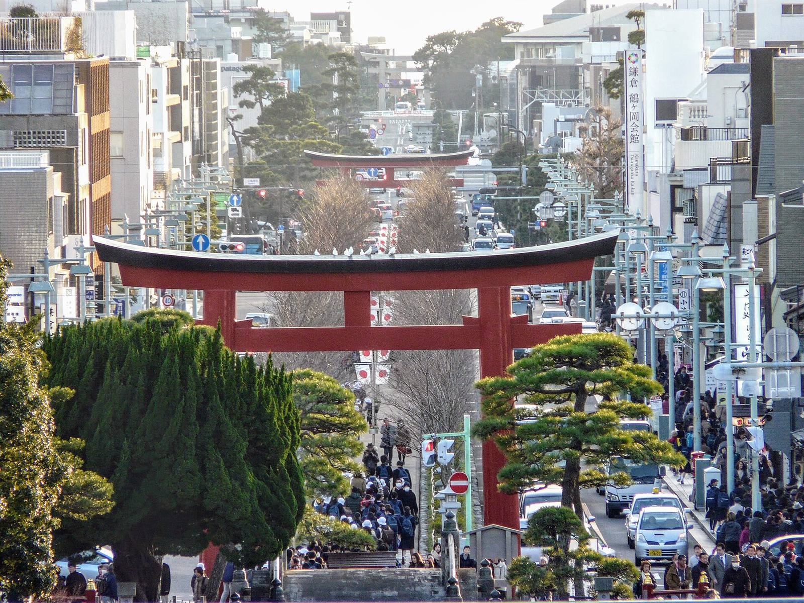
The straight avenue extends about 1.8 kilometers between Tsurugaoka Hachiman-gū and Yuigahama, beside the Namerigawa estuary. Today it is a two-lane street with sidewalks and forms part of Kanagawa Prefectural Route 21. Its surviving historic features include a raised central path, three gates, remains of an earlier seaside gate, and memorials along the route.
Street and central path
Avenue layout
Archaeological investigations indicate that the original avenue was about 33 meters wide. On its upper stretch, between the shrine and the second gate, pines lined the sides and ditches about 1.5 meters wide bordered the road. Pines now remain only beside the first gate. Excavations also revealed remains of a market in open spaces on both sides of the upper avenue.
Dankazura
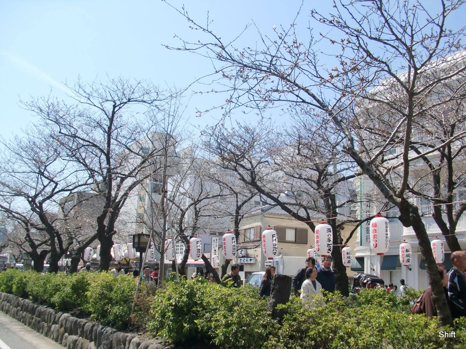
The dankazura, a raised central path, is an earthen embankment edged with stone. It originally ran about 1,300 meters from the shrine to the seaside gate. About 480 meters survive between San no Torii and Ni no Torii. The path narrows toward the shrine, making the approach appear longer, and cherry trees line its surviving section.
Gates and associated remains
The three gates
Three torii, gates marking entry to a Shinto sacred precinct, stand along the avenue. In the current numbering, Ichi no Torii is nearest the sea, Ni no Torii is in the middle, and San no Torii is nearest the shrine. The former numbering ran in the opposite direction: the shrine-side gate was Ichi no Torii, the middle one Ni no Torii, and the seaside gate Hama no Ōtorii. The present Ni no Torii and San no Torii are red reinforced-concrete structures built in 1934; Ichi no Torii is stone.
Ichi no Torii
The present seaside Ichi no Torii stands about 180 meters seaward of the remains of Hama no Ōtorii. It was rebuilt in 1668 from Mikage granite brought from Inushima near Bizen. The 1923 Great Kantō earthquake damaged it so severely that only the lower parts of its pillars remained. Repairs in 1936 reused original stone and added seven replacement pieces from Inushima, while retaining the gate’s general appearance.
Former Hama no Ōtorii
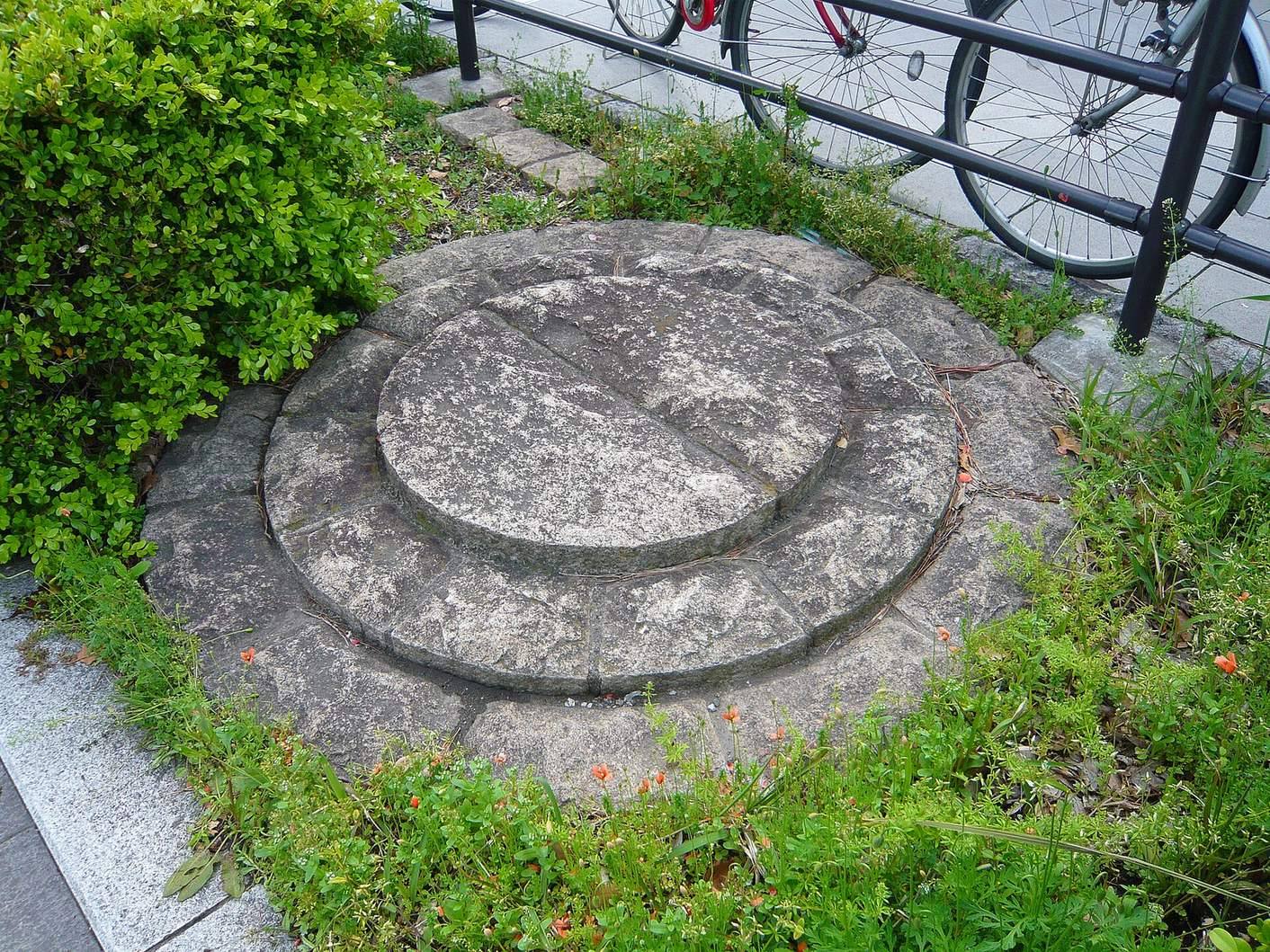
Remains of the earlier seaside gate lie about 130 meters beyond Geba and 180 meters north of the present Ichi no Torii. Discovered in a 1990 archaeological survey, the pillar positions are marked by stone circles in both sidewalks. The pillars are about 160 centimeters thick. Each has a hinoki cypress core surrounded by eight pieces of keyaki wood. Objects found with them date the remains to the Warring States period, and the gate was probably erected by the regional warlord Hōjō Ujiyasu in 1553.
The coastline once lay farther inland than it does today, so the sea was probably close to the gate. The surviving pillar remains preserve the timber construction of this earlier structure.
Crossings and memorials
Geba Yotsukado and the bridges
Geba Yotsukado is the crossing of Ōmachi Ōji and Wakamiya Ōji. The avenue formerly crossed three bridges: Akabashi near the shrine, a bridge over a brook at Ni no Torii, and a bridge over the Sansuke River at Geba. The brook is now covered, though its course remains visible on Komachi Dōri; the Sansuke River was covered in the 1960s.
Komainu figures
A pair of komainu, traditional guardians placed at shrine or temple entrances, stands in front of Ni no Torii. One figure has its mouth open and the other closed, representing the first and last sounds of the Sanskrit alphabet, a and um.
Hatakeyama Shigeyasu memorial
A few meters beyond Ichi no Torii, on the western sidewalk, a grave attributed to Hatakeyama Shigeyasu consists of a hōkyōintō, a Japanese Buddhist memorial tower, and a black stele erected in March 1922. The tower’s construction date and the grave’s attribution are uncertain. The stele identifies the place as the site of Shigeyasu’s residence.