Castra Arutela: A Roman Auxiliary Fort on the Olt Frontier
Site at a Glance
- Popularity
- Medium
- Country
- Romania
- Primary era
- Classical
- Eras represented
- Classical
- Civilizations
- Roman
- Site type
- Military
- Remains
- Fort
On this page19 sections
History
Construction and Roman occupation
Castra Arutela was a Roman auxiliary fort at Poiana Bivolari in present-day Romania, on the left bank of the Olt River. Probably built around AD 138, it formed part of the Limes Alutanus, the Roman frontier zone along the Olt, in the province of Dacia Inferior, later called Dacia Malvensis. Two building inscriptions link its construction to a unit of Syrian archers, the Numerus Syrorum Sagittariorum, acting under Titus Flavius Constans, an imperial official responsible for provincial administration.
The garrison consisted of foot archers originally recruited in Syria. Their duties included watching a long-distance road that ran parallel to the river. A Dacian settlement continued to exist under Roman rule, and a civilian community developed beside the fort. Inscriptions also name Cohors I Hispanorum, an auxiliary cohort, and Legio V Macedonica, a legion. These references do not establish that either unit was stationed at Arutela; they may relate to messengers or individual soldiers temporarily present.
Recorded in Roman geography and the end of the fort
Arutela appears in the Tabula Peutingeriana, a map of the Roman road network, and in the geographical work of Claudius Ptolemy, a second-century author who described places in the Roman world. The latest dated coin found at the fort was issued under Emperor Elagabalus between AD 220 and 222. The fort probably ceased to function around 238 or 239, possibly after flooding by the Olt.
Rediscovery and modern protection
The remains came to light in 1888 during work to capture sulfurous thermal water. Excavations followed in 1888–1889, with further investigations by Grigore Tocilescu and Pamfil Polonic in the early 1890s. Railway construction between Râmnicu Vâlcea and Râul Vadului from 1897 to 1902 covered or submerged part of the fort. The river also damaged the baths, which were eventually lost.
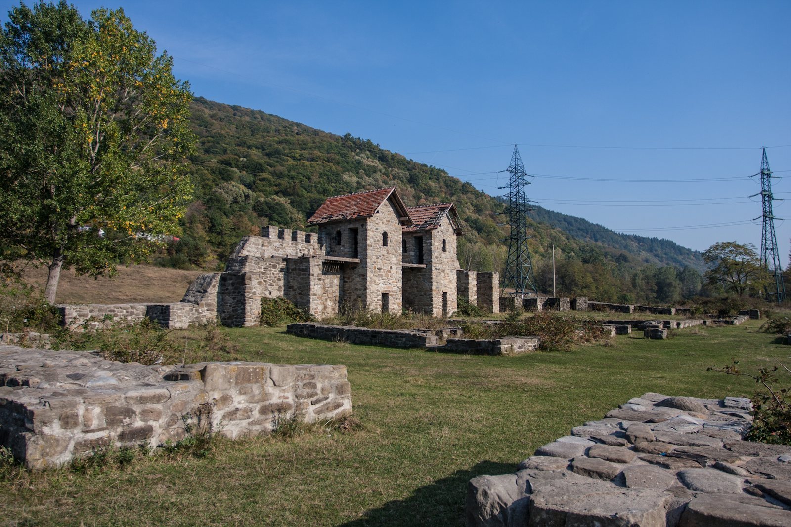
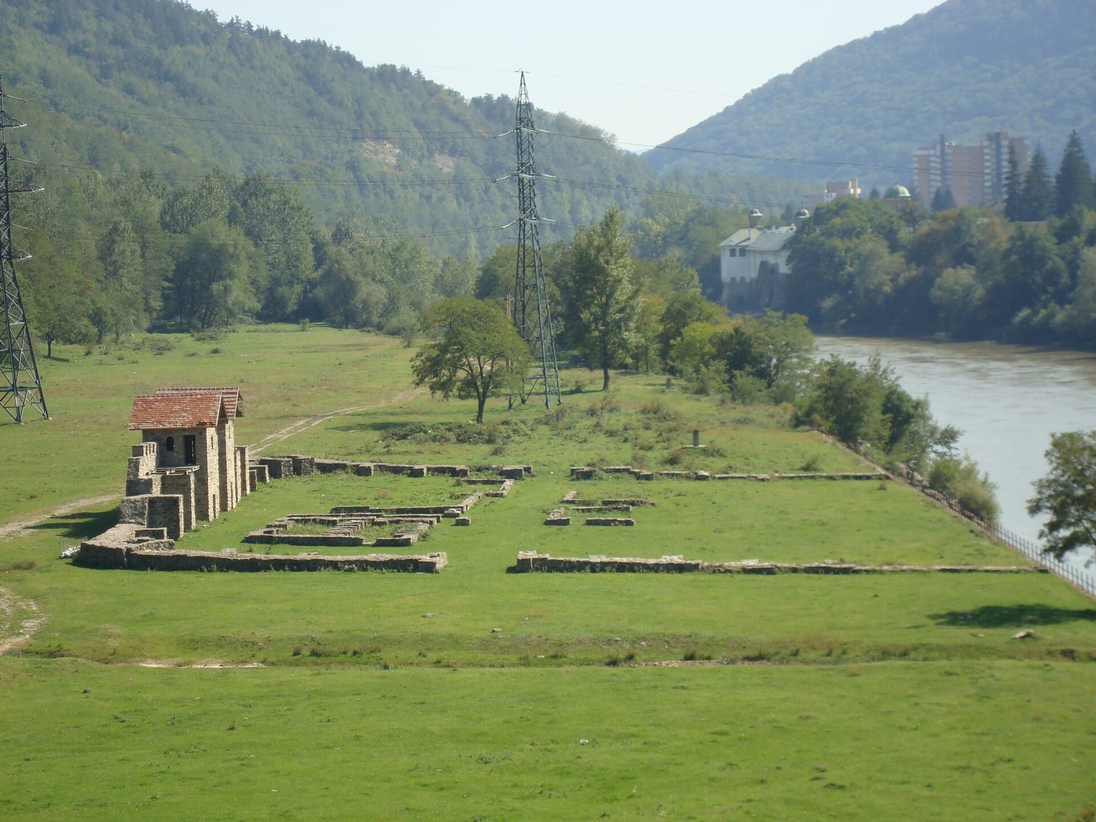
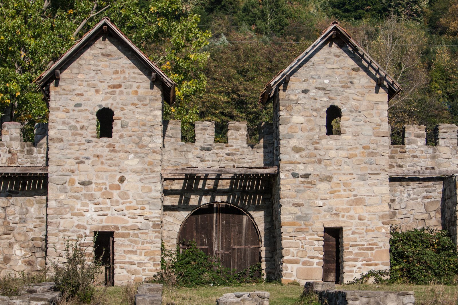
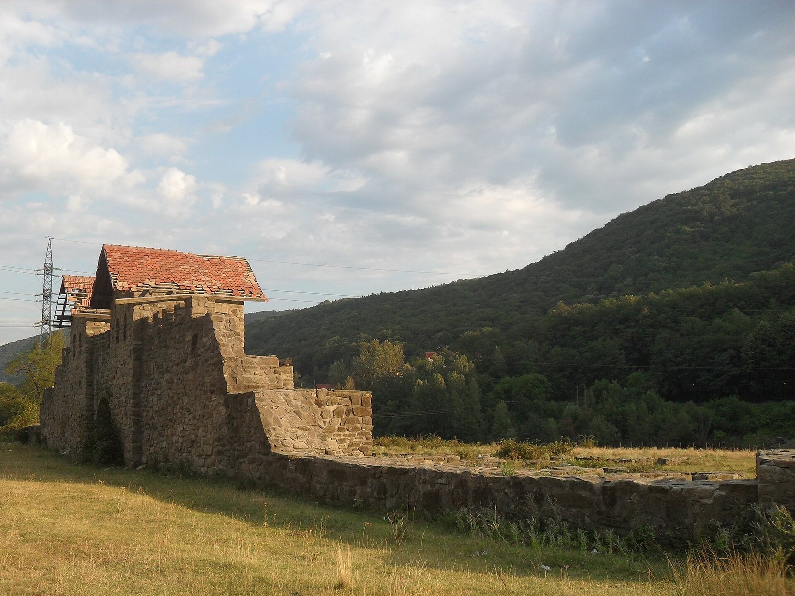
The National Military Museum resumed archaeological work in 1967, with investigations and restoration continuing through 1978 under Dumitru Tudor, Cristian M. Vlădescu, and Gheorghe Poenaru-Bordea. Flooding had destroyed the southwestern part, so work could examine only the northeastern half. In 1982–1983, the main gate and its flanking towers were partly rebuilt using a reconstruction based on hypothetical evidence. Romania included the fort in its national list of historic monuments in 2004, under the protection of its 2001 historic-monuments law. In 2024, it became part of the UNESCO World Heritage property comprising 277 sites of the Dacian Limes.
Remains
Fort enclosure and entrances
The fort stands on a high terrace east of the Olt, between Păușa and Căciulata, at an elevation of about 285–286 metres. Its stone enclosure had a square plan, measuring 60.8 metres on each side and covering approximately 0.37 hectares. The corners were rounded, and the identified construction phase used stone throughout. The defensive wall was 1.6 metres thick, built from irregularly shaped stones. Buttresses on its inner face measured 1.0 by 1.5 metres and were spaced 2.15 to 4.4 metres apart. Niches between them may have served for storage; their proposed use as horse stalls is disputed because of their small size, although horseshoes were found there.
Corner towers
Trapezoidal towers projected slightly beyond the fort’s corners. Their four sides measured 2.3, 1.8, 1.8, and 4.0 metres.
Gates
The main gate faced north to northeast and had a passage 2.8 metres wide. Its rectangular flanking towers projected slightly beyond the wall; each measured 3.4 by 4.5 metres externally and 1.5 by 1.8 metres internally. The two side gates had no towers. Their passages measured 2.85 metres on the right and 3.85 metres on the left. The main gate and its towers were rebuilt in 1982–1983, following a modern reconstruction based on hypothetical evidence.
Interior buildings and roads
Roads and central platform
Within the enclosure, excavators traced the principal road, a cross-road, and a road running around the inside of the perimeter. The first two were paved and about 3 metres wide; the perimeter road was 1.5 metres wide. At the crossing of the principal road and the cross-road stood a stone platform. It may have held a groma, a Roman tool for laying out straight lines and right angles, and possibly a small statue associated with the instrument’s proposed religious use.
Headquarters
The fort’s headquarters building is partly destroyed. Its estimated dimensions are 9.7 by 16.3 metres, but flooding removed its southwestern section. The surviving northeastern side is 9.7 metres long, with walls 0.6 metres thick. A 1.7-metre-wide entrance had a stone floor laid in mortar; a second entrance may have provided additional access. Most of the courtyard was paved. A drainage channel lay near its centre, and a stone water tank stood at the western end of the northeastern wall.
Granary
A building in the fort’s left-front area measures 11.1 by 9.8 metres. First interpreted as a hall for gatherings, it is now considered a possible granary. Its walls were 0.7 metres thick, and it had three entrances. Supports and stone bases along the central axis, each 0.5 metres wide and 1.5 metres long, may have held up the floor. A retaining wall on the side facing the principal road probably supported a loading ramp.
Other buildings
Traces of additional structures include one that may have been a workshop. A separate rectangular building in the fort’s front section measured 20 by 9 metres, but its function is undetermined.
Civilian settlement and finds
Settlement
The civilian settlement lay east and northeast of the fort. It included homes for soldiers’ families and veterans, as well as buildings connected with craftspeople, traders, innkeepers, sex workers, and other service providers. The fort’s baths also stood in this area and served both soldiers and civilians.
Excavated objects
Excavations recovered weapons, vessels, coins, and inscriptions. The coins included issues of Hadrian, Septimius Severus, Julia Domna, and Caracalla. A small bronze fragment points to the presence of a military clerk associated with Cohors I Hispanorum, while a stamp bears the name of Legio V Macedonica. The recovered objects are held at the National Military Museum in Bucharest.
Outlying frontier features
Tower on Teofil Peak
About 900 to 1,000 metres north of the fort, excavations on a small platform on Teofil Peak uncovered a tower near the rock known as Trajan’s Table. Its unusual plan formed roughly three-quarters of a circle, with the straight side facing east. The mortar substructure incorporated fragments of earth. From its elevated position, the tower afforded views along the Olt toward Rădăcinești and toward Văratica and other towers downstream.
Rock-cut Roman road
At the entrance to the gorge, a Roman road cut into the rock ran between Trajan’s Table to the west and Teofil Peak to the east. Its course could still be seen in the late nineteenth century. The area was inundated after the hydroelectric dam entered service in 1982.