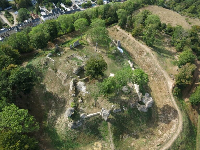
Brionne Castle: A Medieval Keep in Normandy


Site at a Glance
- Rating
- 3.9
- Popularity
- Low
- Country
- France
- Primary era
- Medieval
- External website
- Open
- Eras represented
- Medieval
- Civilizations
- Norman
- Site type
- Military
- Remains
- Castle
On this page10 sections
History
Brionne Castle in France is the partly ruined keep of a fortified Norman castle that served as the center of the County of Brionne, a medieval territorial lordship in Normandy. Built in the late eleventh century or possibly the first quarter of the twelfth century in the Romanesque style, it replaced an earlier stronghold on an island in the Risle. Set above the town and valley, the castle also controlled the route between Rouen and Alençon, which crossed the valley at Brionne from the eleventh century.
Before the Hilltop Castle
An earlier castle stood on an island in the Risle, beneath the present town. It is mentioned in connection with events in 1047 and had already endured at least two sieges, in 1047 and 1090. Part of the island fortress was destroyed in 1735, when mills were constructed on the river. The hilltop castle therefore replaced a stronghold with an established military history.
Brionne’s position at a crossroads linking Lisieux, Pont-Audemer, Rouen, and Évreux has led historians to propose that a fort occupied the site during the Roman period. That interpretation remains uncertain. The secure medieval history begins with the castle and lordship held by members of the Norman aristocracy.
Norman Lords and the Siege of 1047
Geoffrey of Brionne, Count of Eu, held the castle and the County of Brionne. The medieval chronicler Orderic Vital says that Geoffrey received them from his father, while Robert of Torigni describes a transfer made at the will of Richard II, Duke of Normandy. Geoffrey was certainly at least the castle’s castellan, the officer responsible for holding and administering a castle.
After Gilbert of Brionne died, around 1040, Guy of Brionne held the castles and lordship of Brionne as well as the castle of Vernon. Gilbert had been tutor to William, Duke of Normandy, later known as William the Conqueror. William of Poitiers gives a different account, attributing the grant of both castles directly to the duke.
Guy’s possession of Brionne was tested after he was wounded at the Battle of Val-es-Dunes in 1047, a conflict through which William of Normandy strengthened his control over the duchy. Guy took refuge in the castle on the Risle with a substantial armed force and reinforced its defenses. William besieged the stronghold for three years. The defenders capitulated only when famine compelled Guy and his men to surrender.
The Beaumont and Meulan Succession
Around 1089, Robert Curthose, Duke of Normandy, transferred the fortress of Brionne to Roger de Beaumont. The exchange compensated Roger for giving Ivry to William of Breteuil. Robert of Torigni presents another version, stating that Roger’s son, Robert I of Meulan, requested the exchange of Ivry for Brionne.
In 1090, Robert I of Meulan claimed Ivry because he considered it dependent on Brionne. William the Red, King of England, imprisoned him and seized Brionne. Roger de Beaumont obtained his son’s release through negotiations. When Roger died in 1094, Robert inherited his Norman lands, including Brionne, Pont-Audemer, and Beaumont.
The square keep probably belongs to Robert I of Meulan’s lordship. He died in 1118, and his son Waleran IV of Meulan inherited Brionne in 1120. In April 1124, Henry I Beauclerc, the English king who also controlled Normandy, besieged the new castle while Waleran held it. Waleran eventually capitulated.
Royal Conquest and Later Destruction
Philip Augustus, the usual name for Philip II of France, captured Brionne in 1194 during the expansion of French royal control over Normandy. The fortress remained part of a contested military landscape until the English ruined it in 1421.
Its defensive role ended more decisively in the seventeenth century. On 31 July 1626, Louis XIII issued the Declaration of Nantes on the advice of Cardinal Richelieu. The measure ordered the razing and demolition of fortifications that were neither on France’s frontiers nor considered important to the kingdom. Brionne’s defenses were dismantled under this policy, leaving the keep as the principal surviving vestige of the castle.
Protection and Conservation
Arthur Join-Lambert purchased the ruins on 27 May 1869 and donated them to the town of Brionne on the same day. The keep was listed as a historic monument by an order of 12 February 1925. The keep and the surrounding section of hillside were also classified as a protected natural site on 20 April 1925.
Between 1994 and 1996, the town carried out consolidation work while architectural investigations examined the surviving fabric. Wooden pieces and a horizontal beam were removed for dendrochronological analysis, a method that dates timber by comparing annual growth rings. Their poor condition prevented the analysis from producing results about the history or architecture of the keep.
Remains
The surviving castle is centered on a partly ruined Romanesque keep standing on a motte, a raised earth mound used as the base of a medieval fortification. A ditch separates the mound from the plateau. The structure occupies a projecting slope above Brionne on the right bank of the Risle valley, overlooking the town and extending across the valley toward the route that linked Rouen and Alençon.
Exterior Form and Construction
The keep has a square plan measuring approximately 20 by 19.70 metres. Its surviving elevation reaches 17 metres, while the walls are about 4 metres thick. They become thicker at the corners and beside the external flat buttresses. Only the north façade remains relatively well preserved, allowing the principal vertical arrangement to be read as three levels: a lower storey entered through a doorway in the west wall, a first floor, and an upper loft beneath the former roof.
The visible arrangement does not represent the original design. The first construction used rubble masonry, made from irregular stones set in mortar, with longitudinal wooden beams inserted at intervals for reinforcement. Probably in the late twelfth century, regularly cut ashlar stone facings were added to the interior and exterior surfaces. A stepped glacis, or sloping defensive surface, at the base of the buttresses probably belongs to the same phase.
The west-wall doorway is later than the first construction. The keep may originally have presented mostly closed outer walls, as Romanesque keeps commonly lacked external openings of this kind. Square holes in the façades held projecting beams for a wooden balcony running around the building. This arrangement has been compared with evidence for a similar balcony at Loches.
Floors, Openings, and Roof
The first-floor structure rested on joists supported by three main beams. Two large openings in the north wall illuminated a great hall, whose height is estimated at 4.20 metres. Narrow passages once ran inside the north wall beside the windows and are now blocked. Two splayed openings on the exterior correspond to these passages, although their relationship in date is uncertain.
The upper level was formerly covered by a double-pitched roof with open gables. The surviving impression of one roof slope on the north-west wall indicates a pitch of about 10 percent. Wooden hourds, which were projecting timber fighting galleries, crowned the summit and provided a defensive platform around the upper part of the tower.
Interior Alterations
The present first floor probably formed when two earlier levels were combined. Two blocked vaults, one above the other, remain visible in the west wall. The lower vault belonged to a room with a fireplace. One jamb survives, topped by a carved capital. A corridor beginning at one of the north-wall windows leads toward an unidentified space in the north-west corner.
The upper part of the keep was later remodelled. Some spaces were filled, part of a vault was destroyed, and the fireplace and its flue were blocked. The installation of wooden hourds also changed the internal arrangement. Wooden pieces and a horizontal beam found within the blocking of the north wall were interpreted as structural ties, intended to connect the thick walls and reduce movement, settlement, and cracking. The keep is now in ruins and represents the last surviving part of the castle.