Jaciment del Born: Archaeological Remains of Barcelona’s Ribera District
Site at a Glance
- Popularity
- Medium
- Country
- Spain
- Primary era
- Early Modern
- Eras represented
- Medieval, Early Modern, Modern
- Civilizations
- Crown of Aragon, Spanish
- Site type
- Domestic
- Remains
- House
On this page15 sections
History
The Jaciment del Born is an archaeological site beneath the former El Born market in Barcelona, Spain, preserving part of the Ribera district from the late thirteenth century until its clearance in 1717. The excavated remains trace a neighborhood of homes, businesses, and streets that was largely removed to make way for a military citadel.
Life in the Ribera district
Property records describe a neighborhood shaped by household trades and commerce. One property became Barcelona’s first ice house: in 1640 it was rented to the company licensed to bring snow and ice into the city, before the concession moved to a house on Bonaire Street in 1696. Goods belonging to Cardinal Gaspar de Borja y Velasco were stored there during his second visit to Barcelona in 1637. The property passed between the Rovira and Cardona families and was inherited in 1651 by Caterina de Calbà, wife of Dalmau d’Ivorra, Baron of Sant Vicenç dels Horts.
Other houses combined domestic and commercial uses. A large property known as the Colomer house contained a tavern. Saddler Francesc Bassols rented it to surgeon Carles Arnau in 1696 and sold it to surgeon Mateu Hereu in 1700. Their dispute over Arnau’s eviction reached the local magistrate. After the 1714 siege, three Bourbon soldiers were quartered there before the house was demolished in 1716. A public gaming house, called a triquet, offered dice and card games, and less often backgammon and chess. People also used such establishments to make business agreements.
Records also follow houses through changes of ownership and craft. A property held by Antoni Romaguera in the early sixteenth century later passed to apothecary Antoni Vidal and his wife, who granted it to coppersmith Joan Valldossera under a long-term landholding arrangement with obligations to a superior landholder. Valldossera’s son Bartomeu continued the arrangement. In 1694, coppersmith Josep Poal bought a nearby house for 350 Catalan pounds and carried out maintenance three years later. Millstones reused in paving during that work survive at the site.
Households could include several generations and workers. In 1716, saddler’s widow Maria Àngela Carrer lived with her children, a journeyman, an apprentice, and a servant; tenant Josep Font and his wife also occupied the property. Her late husband, Salvi Carrer, had taken part in a lay religious association for mule-renters and in a commercial company formed in 1706. Other records trace houses through shoemakers, viola-string makers, saddlers, and booksellers, including disputes over inheritance, residence, and the right to continue a family business. A property belonging in 1662 to Jaume Isern, a supporter of the Habsburg side, later passed through his family. His granddaughter married Salvador Feliu de la Penya, who took part in Barcelona’s defense and acted for his mother-in-law when the house was sold to its former tenant, Manuel Camins.
War, siege, and clearance
French fleets attacked Barcelona in 1691 and 1697 during the Nine Years’ War, damaging some buildings near the coast, especially the Monastery of Santa Clara. During the War of the Spanish Succession, a conflict over the Spanish monarchy, Barcelona endured a siege in 1714 and thousands of bombardments, with La Ribera among the areas most heavily attacked. After the city surrendered, victorious troops took up quarters in houses and palaces.
King Philip V ordered residents expelled and much of La Ribera demolished for a military citadel and its surrounding security zone. Flemish military engineer Joris Prosper Van Verboom designed a large, five-sided fortress near Portal Nou and the Santa Clara monastery. It was intended to strengthen the city’s defenses and give the authorities control over densely settled districts. The citadel’s foundation stone was laid on 1 March 1716. Demolition began in March 1717, removing 38 streets and 1,016 houses; construction was completed on 25 January 1725.
Property histories record the disruption at house level. A house on Joc de Pilota Street was destroyed in the French attack of 1691. Its owner’s widow could not rebuild it, and a dispute followed over the plot and the value of its stones. The property later passed to Joan Pau Llorens and his business partner, apothecary Josep Duran i Mora. By its final years, it had become a shop without upper floors. Another house, badly damaged, probably in the 1697 bombardment, was sold at a ruinous price to master builder Baltasar Bertran. Viola-string maker Pere Matas, who had owned a house in the district since 1690, demolished it in 1716.
Park, market, and archaeological discovery
After the citadel was demolished in 1869, the area became the Passeig de l’Esplanada, established as a park in 1802 and described as Barcelona’s first public park. A market building was constructed in 1871 and opened in 1876. Archaeological work began in connection with a proposed underground car park in 1990–91, followed by investigations in 1994, 1998, and 2001–02. The exceptionally well-preserved remains found in 2001 led the city to protect the site and develop a museum plan.
Excavation, conservation, and restoration continued during the market’s adaptation as a cultural center in 2005–09. Two burials uncovered in 2003 were studied anthropologically, while work also addressed stonework, brickwork, and architectural coatings. The site received national cultural-asset status as an archaeological zone in 2006. Since 2013 it has formed part of El Born, Museum of the History of Barcelona, a cultural and museum center incorporating the archaeological remains.
Remains
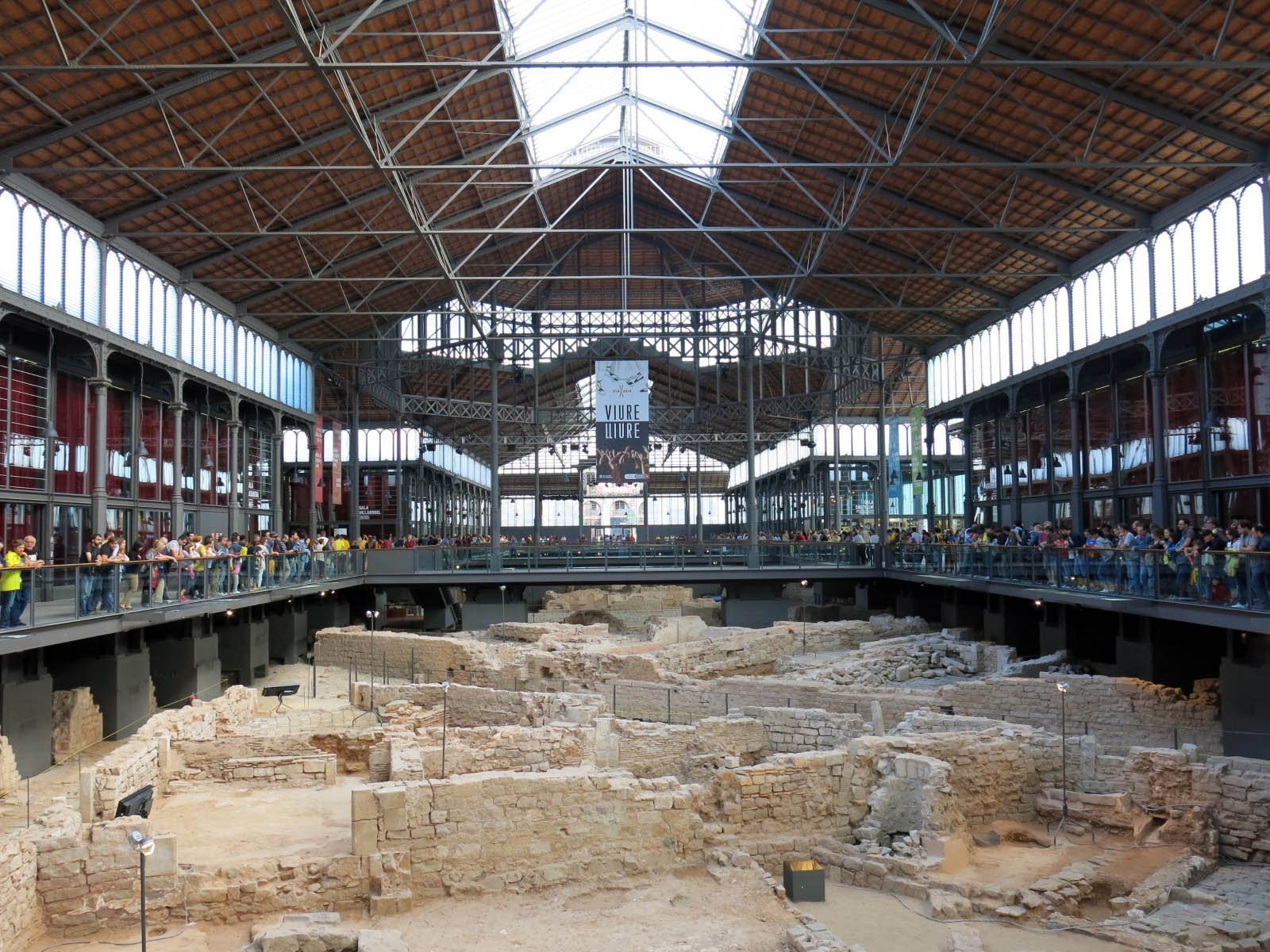
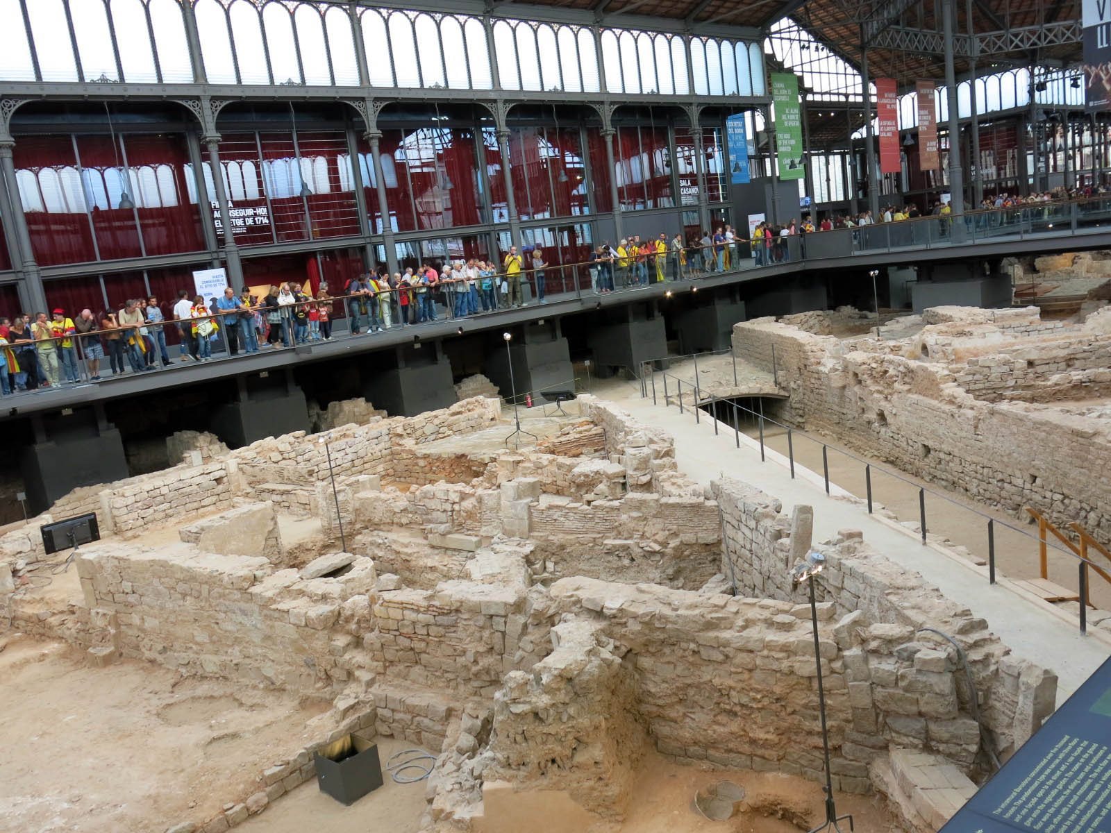
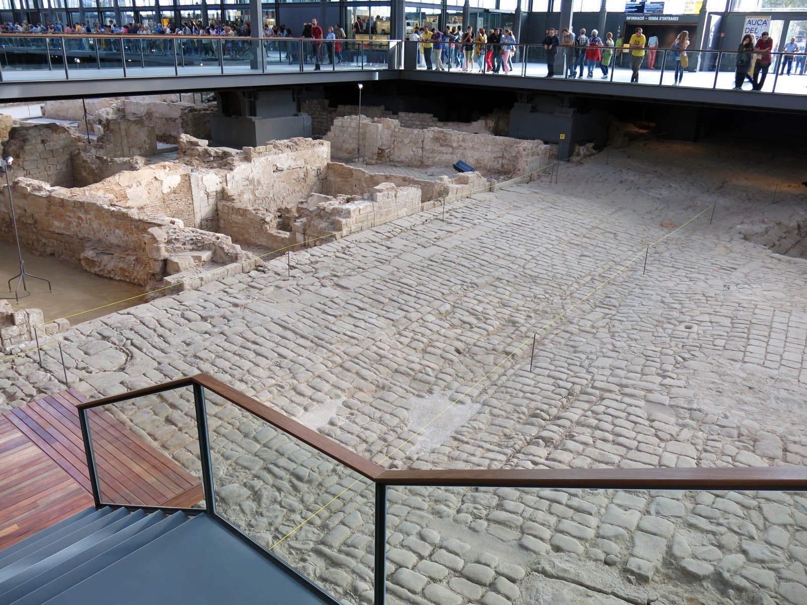
The archaeological area lies beneath the former market hall and covers about 8,100 square metres, only a small part of the 295,705 square metres cleared for the citadel and its security zone. It is bounded by present-day Carrer de la Fusina, Carrer Comercial, Carrer de la Ribera, and Plaça Comercial. Above the remains, the market hall has a steel frame and extensive glass elements, in the style of Catalan Modernisme, an artistic and architectural movement of the late nineteenth and early twentieth centuries. Its column supports required localized foundations, limiting disturbance below, while the building’s position and orientation shaped the area preserved.
The canal and street plan
Rec Comtal and streets
The excavated neighborhood is arranged around a segment of the Rec Comtal, a historic irrigation canal. An approximately 85-metre stretch, about four metres wide, formed a central axis and influenced the orientation of some buildings. The western area around the canal contains remains associated with crafts and industry. Homes, palaces, guild premises, and leisure establishments occupied the central area, while smaller, simpler houses characterized the eastern maritime or fishing quarter. Fragments of eight streets survive, along with the full extent of Bornet Square.
Street widths varied across the district. Micó Street measured 2.4 metres, while Corders de Viola and Ventres streets were about 2.6 to 2.8 metres wide. Xucles Street measured 4.4 metres, Bonaire Street four metres, and Joc de Pilota Street 5.8 metres. The southern area followed a grid of eight blocks, with streets including Dies Feiners, Bonayre, d’en Malla, and n’Abella. Houses along Bonaire Street formed part of the maritime quarter, and the line of properties extended from there toward the beach.
Bridge and Bornet Square
A bridge crossed the canal where dels Ventres and Na Rodés streets met. It is also known as the Bridge of the Butcher’s Shop at Pla d’en Llull and the Na Rodés Street Bridge. Its width ranges from 5.5 to 9.5 metres. A well-preserved private bridge at the northern end of Ventres Street is the only privately owned bridge found in an archaeological excavation in Barcelona.
Bornet Square measures 10.6 metres across at its center, about 15 metres where it meets Gensana Street, and approximately 12.6 metres beside the canal bridge. The low-lying area between the Rec Comtal, Gensana Street, Pla del Bornet, and the bridge was prone to flooding when the canal overflowed.
Homes, workshops, and shared spaces
Blocks and houses
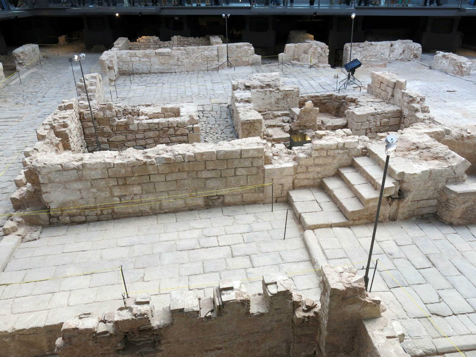
The excavated area contains 42 complete houses and fragments of eleven more. Together, the houses accommodated 77 families, comprising 323 people. Buildings were Gothic, a medieval European architectural style, with later alterations. A usual house had a ground floor and two upper storeys, and stood more than ten metres high. One block included properties that had once formed a larger house, recorded in 1363 as belonging to Galceran Carbó and facing three streets, before being divided over time.
Three residential blocks were exposed in the northern area between Gensana, dels Ventres, and Na Rodés streets and Pla d’en Llull. Homes, palaces, work areas, and storehouses formed part of the excavated buildings. In the central neighborhood, a block between Xucles, Bonaire, Joc de Pilota, and Roldó streets had residential and leisure uses. About three-quarters of it was occupied by houses belonging to the Boxadors, merchants associated with the snow and ice trade.
Domestic features and drainage
Streets had varied surfaces, including stone paving and compacted earth in the eastern quarter. Sewers and cesspits served the neighborhood, and some houses had more complex drainage. A shop inventory from the mid-seventeenth century describes a double-height shop with a loft used for storage beneath two further floors of the house.
A terrace shared by the Colomer and Poal houses at the rear served as an interior-block courtyard above the Trotxo house, which faced Xucles Street. A latrine survives in very good condition. Millstones reused in exterior paving during Poal’s 1697 maintenance work remain visible.
Inn and commercial premises
The large Hostal de l’Alba stood opposite the bridge over the Rec Comtal and faced the Santmartí house, where mules were rented. Part of the inn’s ground floor was used as a storehouse by apothecary Duran. Many kaolin pipes were found in that space.
Burials and archaeological finds
Burial areas
Excavations in 1990–91 revealed two burial grounds, or necropolises, associated with Roman and Islamic periods. Two further burials, found in place at the south-southwest edge of the excavation in 2003, were studied anthropologically. Near Carrer del Comerç, human remains were associated with a possible Islamic-period burial ground whose date remains uncertain.
Objects and traces of occupation
Finds from the site include ceramic plates and jars, smoking pipes, weapons, cannon projectiles, and glass and ceramic flasks. At the annex on Carrer Comercial 5, a gravel layer containing Roman pottery was accompanied by glazed ceramics and animal remains. The archaeological record also includes fragments of floors, market-column foundations, drains, and services associated with the market building and its later renovation.