Saint-Marcouf Islands: Strategic Outposts and Coastal Fortifications
Site at a Glance
- Popularity
- High
- Country
- France
- Primary era
- Modern
- Eras represented
- Early Modern, Modern
- Civilizations
- British, French
- Site type
- Military
- Remains
- Fort
On this page13 sections
History
The Saint-Marcouf Islands are two uninhabited islands in the English Channel off the eastern coast of the Cotentin Peninsula in France. They served as a religious retreat and later became a strategic position for controlling shipping between Cherbourg and Le Havre.
Saint Marcouf and the early name
In Roman times, the islands were called Duolimonis, meaning two silt deposits. Their present name comes from Saint Marcouf, a sixth-century Christian monk who withdrew there for Lent. A monastic presence continued on the islands until the fifteenth century.
After Marcouf died, his remains were buried at Nanteuil Abbey near Coutances, which he had founded. In 898, they were moved to Saint-Marcoul Priory at Corbeny to protect them from Viking raids. His relics were believed to cure scrofula, a disease involving infected lymph nodes. French kings consequently made a pilgrimage to Corbeny on the day after their coronations at Reims.
Quarantine and British occupation
After plague returned to Marseille in 1720, Henry Le Berceur, Marquis de Fontenay and owner of the islands, leased them to the French state for 1,000 livres a year, using the pre-decimal French currency. The arrangement allowed the king to isolate sailors arriving from Marseille. The quarantine station at Tatihou was not yet complete.
The islands’ position made them valuable for disrupting shipping, but France had not fortified them for lack of funds. In July 1795, sailors and marines from the British Western Frigate Squadron, led by Captain Sidney Smith aboard HMS Diamond, took possession. British gunboats, including Badger, Hawke, Shark and Sandfly, supplied labor and materials. Royal Engineers built redoubts, or small defensive forts, and shore batteries, which marines and Royal Artillery troops helped man.
The British used the islands as a forward base for the blockade of Le Havre, for intercepting coastal vessels and as a transit point for French émigrés. In December 1795, the crew of Shark mutinied, partly in protest at harsh conditions on the islands, and handed the ship to the French. A major French effort to retake the islands was defeated on 7 May 1798. The attacking force suffered 1,700 casualties, while the defenders had five. The Count of Frotté, a royalist military leader in Normandy, stayed on the islands several times.
In 1800, First Consul Napoleon Bonaparte ordered Robert Fulton to use the Nautilus, regarded as the first military submarine, against the British position. Fulton brought it to Growan, near Isigny, on 12 September, intending to attack the gunboats guarding the islands. He made two attempts, but the gunboats sailed away before he could reach them. Deteriorating weather prevented further attempts that winter.
Under the 1802 Treaty of Amiens, a peace agreement between Britain and France, Britain returned the islands to France, and its remaining troops left in May. French fortification work began in 1803 and was completed by 1812. The garrison initially operated independently and was later attached to the stronghold of La Hougue. Officers’ and battery guards’ families lived on the islands; during the nineteenth century, births and deaths there were registered at Saint-Vaast.
French defenses and nineteenth-century use
Under Napoleon III, France added a further line of defenses between 1860 and 1867. The islands were not attacked again until the twentieth century. In 1871, about 200 people associated with the Paris Commune, a revolutionary municipal government in Paris, were imprisoned there in deplorable conditions.
Second World War and later stewardship
German forces took the islands without resistance around 1940. During preparations for the Allied landings in Normandy, Allied commanders suspected that the islands formed a German outpost armed with heavy batteries and decided to neutralize them before D-Day.
At 4:30 a.m. on 6 June 1944, four U.S. soldiers swam to the islands carrying knives: Sergeant Harvey S. Olson and Private Thomas C. Killeran of Troop A, and Sergeant John W. Zanders and Corporal Melvin F. Kenzie of Troop B. Finding the islands undefended, they marked the ground for a landing. At 5:30 a.m., 132 men from the 4th and 24th Cavalry Squadrons of the U.S. 4th Cavalry Group landed under Lieutenant Colonel Edward C. Dunn to secure the approaches to Utah Beach. The islands became the first French territory taken by Allied seaborne forces on D-Day. Mines along the shore caused 19 American casualties: 17 wounded and two killed.
The islands became part of the commune of Saint-Marcouf on 30 April 1987 and are owned by the French state. Île de Terre became a protected bird reserve in 1967. In 1981, the islands and their public maritime domain received scenic-site status under France’s 1930 law. They also lie within the area of the D-Day landing beaches included on the UNESCO World Heritage List. Historic-monument listings followed in 2015, and the fortifications on Île du Large and the land beneath them were classified in 2017.
An association dedicated to Île du Large began seeking permission for preservation work in 2003 and received it in 2009. Restoration of the fortifications has taken place since then.
Remains
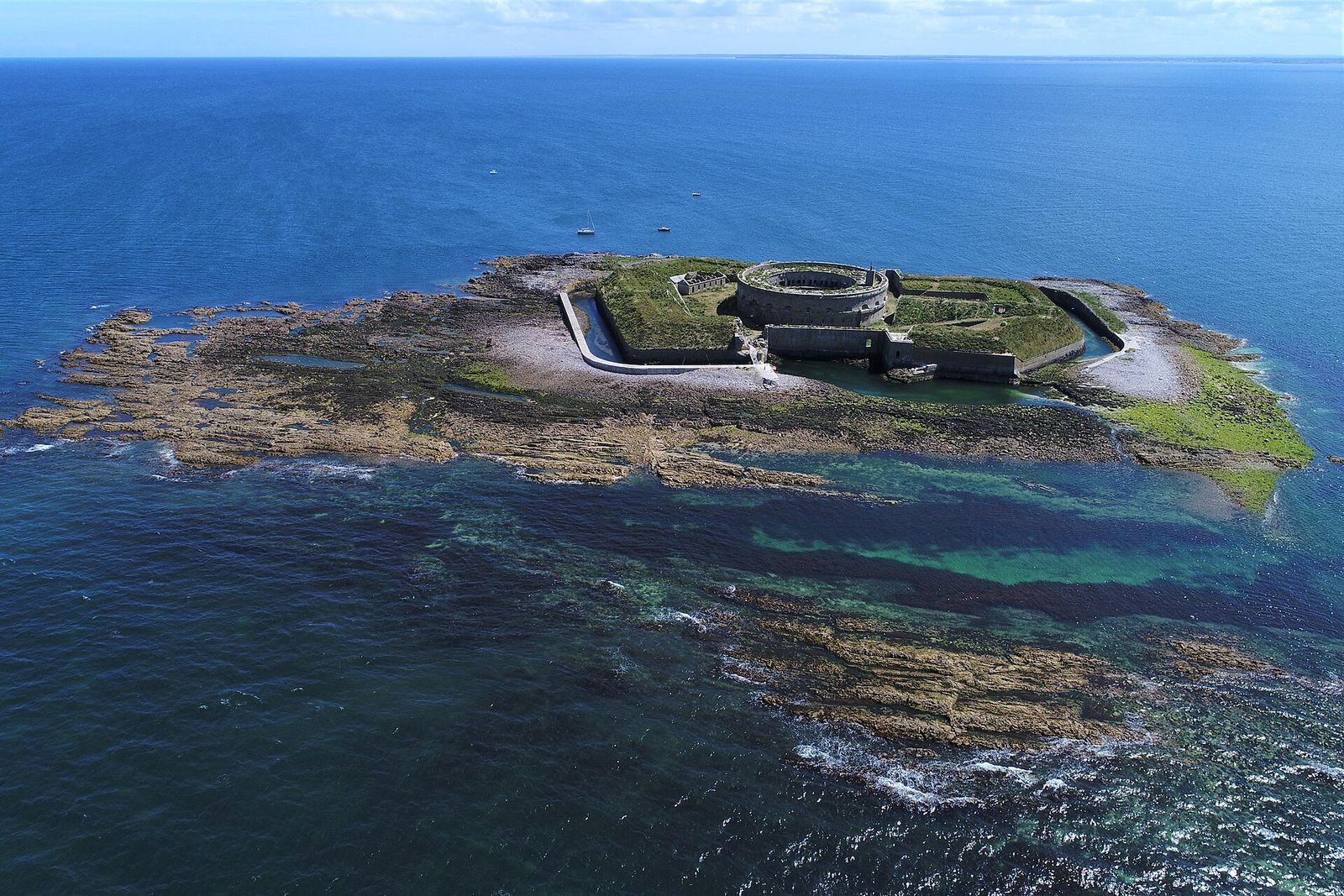
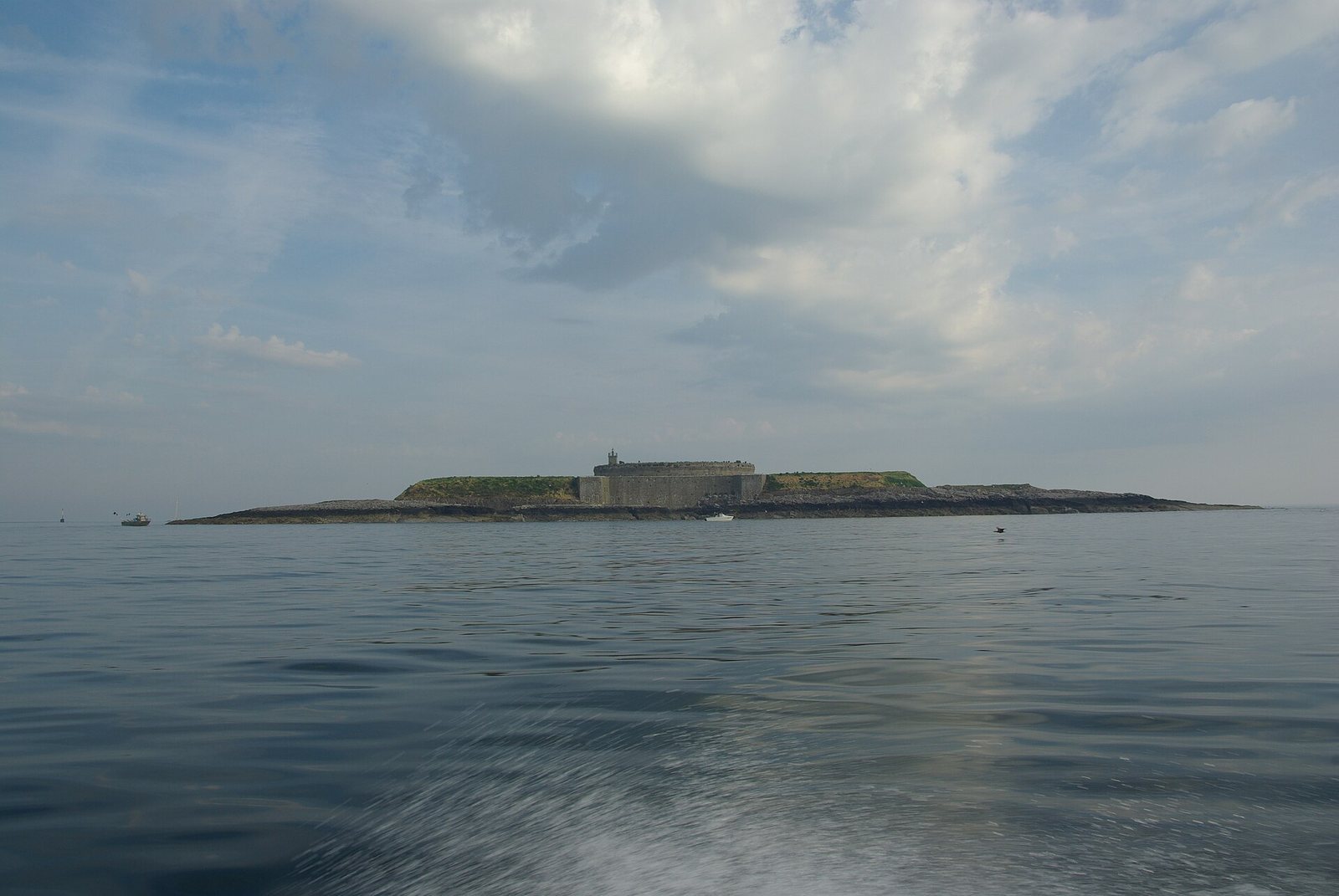
The archipelago lies about 7 km off the eastern coast of the Cotentin Peninsula; the coast at Ravenoville is about 6.5 km away. The larger Île du Large is roughly 500 m east of Île de Terre. Together, the islands cover about 1,400 hectares and rise to a maximum of 10 m. They consist of Armorican sandstone, associated with the Armorican Massif, a geological region of western France.
Fortifications on Île du Large
Main circular fort
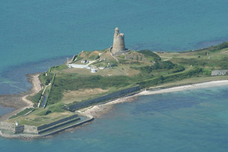
The fortification complex covers about 2.5 hectares. It includes a principal circular fort about 53 m across, within a larger complex about 170 m in diameter. The fort has 48 cannon firing ports on two levels, each level containing 24 casemates, or protected chambers for guns or troops. Seven underground chambers and a cistern also survive. The fort could accommodate 500 troops.
Outer defenses and later installations
Moats cut into the rock ringed the complex at the water’s edge. Works added between 1860 and 1867 included a quay, a powder magazine and a semaphore station, which used visual signals to communicate over distance. The sea later reclaimed the quay. The fortifications have fallen into ruin and are undergoing restoration.
Lighthouses
A lighthouse built within the fort in 1840 was destroyed by German forces during the Second World War. A lighthouse on the larger island dates to 1948.
Île de Terre
Shore battery and guardhouse
The island’s fortifications date from 1849 to 1858 and comprise a shore battery and a guardhouse capable of housing about 60 troops. The enclosure and guardhouse are among the island’s listed historic features.
Birdlife
Gulls and cormorants are the principal birds on Île de Terre. Tens of thousands of gulls shelter on the islands during winter.