Arslanagić Bridge: Historic Trade Crossing in Trebinje
Site at a Glance
- Popularity
- Medium
- Country
- Bosnia and Herzegovina
- Primary era
- Early Modern
- Eras represented
- Early Modern, Modern
- Civilizations
- Ottoman
- Site type
- Infrastructure
- Remains
- Bridge
On this page14 sections
History
Arslanagić Bridge is a historic stone crossing in Trebinje, Bosnia and Herzegovina, originally built under Ottoman rule on a major route between Dubrovnik and the Constantinople Road. Its construction date and patron remain disputed. One interpretation places it in the sixteenth century and dates its completion to 1573–1574; another identifies the present bridge as a later seventeenth-century structure.
Medieval route and disputed beginnings
The bridge originally stood about five kilometres upstream of Trebinje, near the medieval town of Mičevac. Its crossing formed part of a route connecting Dubrovnik and the Adriatic coast with the Constantinople Road, a major overland way toward the Ottoman capital. The route was used in the Middle Ages, before Ottoman rule. Its eastern branch passed through the Trebinje region toward Onogošt, the Piva area, the Tara and the Lim. Caravans travelling from Dubrovnik reached trading centres including Skopje, Sofia, Thessaloniki, Constantinople, Belgrade and Buda.
Under the sixteenth-century interpretation, the bridge belonged to an Ottoman programme of road building and was commissioned by Mehmed Pasha Sokolović, the empire’s chief minister, or grand vizier. It was said to commemorate his son Kasim Kurd-beg, who briefly governed the Ottoman district of Herzegovina in 1571–1572. In 1572, the French traveller Philippe du Fresne-Canaye crossed one branch of the Trebišnjica on foot and the main channel by boat. Pierre L’Escalopier recorded a stone bridge there in March 1574. If his bridge was the present one, these observations place its completion between January 1573 and March 1574.
L’Escalopier also attributed a nearby caravanserai, a roadside lodging for travelling merchants, to Mehmed Pasha. He described it as a place built so that travellers would pray for the soul of the pasha’s son. A foundation deed for Sokolović’s charitable endowments refers to a long bridge in Herzegovina beside a caravanserai, prayer room and water source. These references support the proposed connection, but do not settle whether the bridge described was the one that survives today.
A competing interpretation holds that Sokolović’s bridge was elsewhere and had disappeared by 1580. It dates the present crossing to the second half of the seventeenth century, perhaps around 1650–1690, and proposes Hajdar-beg Kusturica as its builder. In 1696, a Venetian official in Kotor recorded the death of a man who had paid to build a bridge near the Trebinje monastery. The historian Alija Bejtić identified him as Kusturica, but the builder’s identity is not certain.
Other proposed builders are also unconfirmed. If the bridge dates to the sixteenth century, Hajredin, the architect of Mostar’s Old Bridge, may have taken part. Twelve masons from Dubrovnik were sent to the Ottoman governor of Herzegovina in June 1568, and their involvement has also been suggested. Although Arslanagić Bridge resembles Mostar’s Old Bridge in some features, it is not considered a work by Mimar Sinan, the Ottoman Empire’s leading imperial architect.
Several traditions explain the name. One says that Arslan-aga, an Ottoman title-holder whose precise office is unclear, received permission to collect a toll at the crossing. Another links the name to a village that developed around the bridge. A separate legend credits a man named Kusturica with building it using a sultan’s reward for winning a duel. Nineteenth-century stories also connected its origins with Anne of Anjou, a thirteenth-century Serbian queen consort, and with a destructive earthquake.
Trade, tolls and military control
The crossing linked central Bosnia with Novi, now Herceg Novi, and carried substantial commerce, particularly salt. In the seventeenth century, attacks by forces from Herceg Novi and by Montenegrins made the Via Jesera, a route through the Jezera region, unsafe for Dubrovnik caravans. Traffic instead travelled from Trebinje toward Foča.
A toll and guard post regulated cargo at the bridge. In 1684, men from Novi took up duties as its guards. Venice captured Novi in 1687, prompting wealthy Muslim residents to move toward Trebinje. Arslan-aga is said to have been among them and to have received the right to collect tolls. In 1694, Venetian forces destroyed a fortified guard tower at the crossing to prevent Ottoman troops from using it as a strongpoint.
Dubrovnik sought to divert trade from Venetian-held Novi and Risan. In 1713, Trebinje captain Osman Resulbegović, an official with local military and administrative responsibilities, installed strong timber gates to control cargo. New roads toward Dubrovnik also reduced the crossing’s importance.
Damage, relocation and changing identity
In 1944, an explosion during an attempt by Chetnik forces to demolish the bridge destroyed about eight metres of its left wing. After the war, the damaged section was repaired with a narrow strip of concrete. Around 1890, the guardhouse had been removed and minor repairs made to the bridge.
Construction of the Gorica reservoir for the Trebišnjica hydroelectric system submerged the crossing in 1965, and it remained underwater for about a year. After the reservoir was drained, the bridge was taken apart stone by stone in 1966, and its blocks were stored in a nearby field. Relocation began in 1970. The numbered stones were carried by boat and reassembled downstream at Gradina, Trebinje, by 1972, in a project designed by Energoinvest of Sarajevo. The original village was mostly inundated, with only a few houses left above the reservoir.
In 1993, Trebinje’s municipal authorities renamed the bridge Perović Bridge, arguing that the Arslanagić family had previously used the surname Perović. The change has also been linked to attempts to deflect nationalist hostility. The original name remained in popular use. The bridge is listed as an immovable cultural property of Republika Srpska and was declared a National Monument of Bosnia and Herzegovina in 2006.
Remains
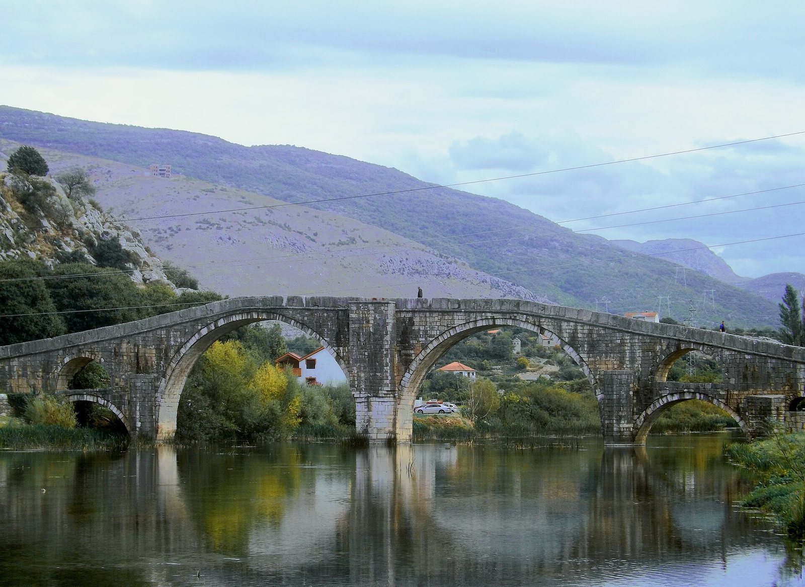
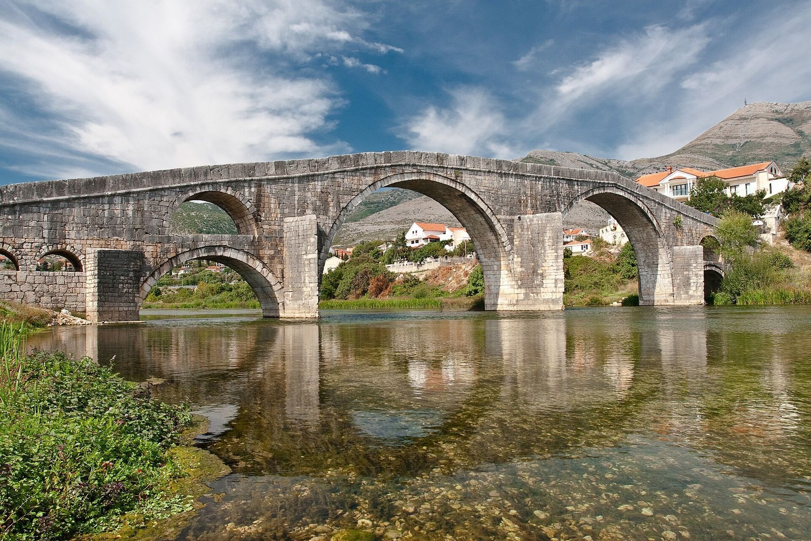
The bridge is a long stone structure adapted to a river profile with a steep right bank. Four semicircular arches form the main crossing, supported by piers between the spans. Its approaches rise from the banks to meet the roadway. Tufa or travertine, calcium-carbonate building stones, and mortar are used in the stonework, with limestone also present in the piers.
Main crossing
Arches and supports
The bridge’s overall length is about 92 m, and its greatest height above the water is about 15 m. From the left bank to the right, the four principal openings span 8.95 m, 17.66 m, 18.60 m and 9.00 m. The three piers between them measure 2.29 m, 3.57 m and 2.26 m across. Together, the openings and intervening supports extend 62.33 m.
The central pier is 3.57 m wide and 8.97 m long when its projecting ends are included. Its triangular upstream projection extends about 3.60 m beyond the bridge’s plan and is shaped to divide the water flow. A polygonal support projects about 1.5 m on the downstream side. The other piers have smaller versions of these projections. At roadway level, the central pier broadens downstream into a platform-like form, though later alterations make its original shape uncertain.
Arch profiles and flood openings
The two larger central arches differ in span by about a metre and differ accordingly in height. Their bases begin at different levels, and their junctions with the central and flanking piers are not identical. Above each of the smaller main arches is a semicircular relieving opening, a smaller gap that reduces the weight over the main arch. These openings span 5.42 m on the left and 5.49 m on the right.
Approaches and roadway
Bank approaches
On the left bank, a ramp about 22 m long reaches the ground in two levels. Three small openings in its lower level allow floodwater to pass; their listed spans are 2.10 m and 1.27 m, and the two piers between them measure 0.90 m and 0.95 m. On the right bank, protective wing walls extend the approach by about 8 m.
Roadway and edges
The roadway is about 3.5–3.6 m wide, while the width between the arch faces varies around 4 m. Its line inclines gently toward the lower left bank, changes above the large arches, and descends more steeply toward the banks. The stated grade is about 3% through the middle and 17% and 20% on the sides. A shaped stone band marks the roadway line along the facades. Stone-slab parapets, low protective walls at the edges, are about 20–22 cm thick.
Guardhouse and architectural form
Former guardhouse
A single-storey stone guardhouse once stood above the central pier. It was about 4–5 m high, with two arched passage gates and a guard’s room above them. Heavy double doors closed the passage. The structure may have been added after the bridge was built or may have formed part of its original design.
Comparison with Alcántara Bridge
The arrangement of Arslanagić Bridge was once taken as evidence of Roman construction because it resembles Alcántara Bridge in Spain. Both crossings have two large arches supported at a central pier, smaller openings toward the approaches and an arch-like feature above the central pier. This is a resemblance in form, not evidence that Arslanagić Bridge is Roman.