Sint Servaasbrug: Maastricht’s Historic Meuse Crossing
Site at a Glance
- Popularity
- High
- Country
- Netherlands
- Primary era
- Medieval
- Eras represented
- Medieval, Modern
- Civilizations
- Duchy of Brabant, Dutch, Holy Roman Empire
- Site type
- Infrastructure
- Remains
- Bridge
On this page16 sections
History
Roman crossing and medieval bridge
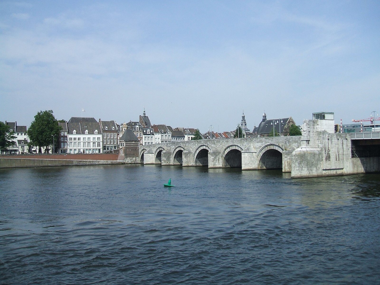
Sint Servaasbrug is a historic bridge across the Meuse in Maastricht, Netherlands. A Roman crossing stood here by about AD 50, on the Via Belgica, a Roman road linking Cologne with Bavay. The present bridge was built between 1280 and 1298, and the crossing is commonly regarded as the oldest bridge in the Netherlands, though much of its surviving structure is reconstructed.
The Roman crossing may have been made of wood, but its construction and the possibility of a later fourth-century replacement remain uncertain. It may have stood about 130 metres south of the present bridge. In July 1275, a bridge collapsed beneath a large procession, killing 400 people. It may have been the Roman crossing, but was more probably an early medieval successor, perhaps aligned with today’s Maastrichter Brugstraat.
The chapter of Saint Servatius, a community of canons attached to the church, commissioned the bridge that replaced it. Funds included contributions encouraged by an indulgence, a Catholic remission of temporal punishment for sins whose guilt had been forgiven. On 29 January 1284, 19 bishops authorized the grant at Orvieto. The bridge also crossed a jurisdictional boundary: until 1794, its southern part belonged to Liège and its northern part to Brabant. This division formed part of Maastricht’s system of joint rule.
Ownership and early modern changes
In 1274, Holy Roman Emperor Rudolf I ruled that maintenance spending could not exceed toll income. Disagreements between the bridge-owning chapter and the city followed. An agreement in 1349 assigned the city three-quarters of the upkeep costs in return for financial contributions from the chapter. Two canons and two aldermen, municipal officials, were to inspect the bridge every year.
The city plan made by Simon de Bellomonte around 1570 is the earliest reliable image of the bridge. Violence also marked its history: killings took place there during the Spanish Fury, the 1576 sack of Maastricht by mutinous Spanish troops, and during the 1579 capture of the city by Alexander Farnese, a Habsburg military commander and governor in the Low Countries. Images of the killings continued to circulate into the seventeenth century.
The city acquired ownership of the entire bridge in 1647. After French forces arrived in 1794, it became property of the French state. Major repairs were carried out in stages from 1683 to 1716. Work included dismantling and rebuilding arches and, in some places, parts of their piers, with old stones reused where possible. Tolls varied according to whether a person, animal, or vehicle crossed. Because this revenue did not meet maintenance costs, the city also required contributions through bequests and payments from new citizens and people convicted of offences.
Nineteenth-century transport and fortifications
In the 1820s, a stone arch replaced the timber span at the Wyck end. Chambers were built into it so the arch could be blown up for defence; Maastricht remained a fortified city until 1867. In 1836-37, stone parapets were replaced with cast-iron railings to widen the sidewalks. The railings were removed in 1932, and some fragments survive elsewhere in the city.
As traffic increased late in the century, the approach streets were widened, and Wycker Brugstraat was extended toward the station area. Four omnibuses ran between Wyck station and Boschstraat from 1884 to 1896, when tram service began. The largely single-track tram line had a double-track section on the bridge. Gas trams gave way to horse trams in 1903; those ran until 1914, and buses took over the station-to-city service from 1918.
Reconstruction and war damage
Sections of the bridge collapsed in 1926, 1928, and 1931. The city proposed demolition and replacement, but the national government rejected the plan, while public opposition supported retaining the old bridge. The Wilhelminabrug, built about 300 metres downstream, provided another river crossing. From 1932 to 1934, the Sint Servaasbrug was reconstructed and widened by 2.5 metres to address damage from floods and heavy ice. The name Sint Servaasbrug became official in 1932; before then, its official name was Maasbrug, while people also called it the old bridge. The reconstructed bridge was inaugurated on 20 November 1932.
On 10 May 1940, Dutch troops blew up the steel section at the Wyck end to hinder the German advance. The explosion caused little damage to the rest of the bridge and barely delayed the advancing troops. A temporary crossing was available by 11 May, followed by a more permanent emergency bridge on 28 August.
During the German retreat in 1944, a resistance group tried to sabotage the demolition charges, with little effect. German troops partially blew up the bridge on 13 September, the day Wyck was liberated and one day before Maastricht. No arch was completely severed. Temporary repairs enabled traffic to resume on 27 September, and the bridge was reconstructed again in 1948. Two towers beside the main pier were not rebuilt.
Traffic changes and protection
After the war, traffic placed increasing strain on the bridge. The opening of the John F. Kennedybrug in 1967 and the Noorderbrug in 1984 eased that pressure. Motor traffic was excluded sometime in the 1990s, and in 2000 the bridge was arranged for pedestrians and cyclists. It is protected as a national monument in the Netherlands.
Remains
The bridge is 160 metres long and 9 metres wide. Its stonework has seven round arches, each spanning about 12 metres, carried on seven substantial piers. The present structure is largely concrete faced with stone, combining reused original masonry with new stone. Its recorded materials also include Namur stone, brick, and steel. Foundations were strengthened, and secondary arches beneath the water between the piers help brace the structure against floods and heavy ice.
Bridge structure and river channels
Stone arches and eastern span
The medieval bridge had nine stone arches and a removable timber span at the Wyck end, which could be taken away quickly if the city faced an attack from that side. The timber span was later replaced with a stone arch. During the 1932-34 reconstruction, two arches at the Wyck end were removed to improve shipping access. A steel movable span now crosses the eastern shipping channel. When it is raised for passing vessels, pedestrians can still cross the raised section.
Sealed western arch
A change in the river’s course left the westernmost arch dry around 1640. It was bricked up and incorporated into a quay wall, while eight stone arches remained in use. The buried structure is also called the bridge’s tenth arch. Canal works exposed it in 1850, and it was uncovered again during the Maasboulevard works in 2005. Its deteriorated original masonry was largely removed in 2007; fragments were incorporated into a replacement concrete structure.
Gateways and river edge
Former gates and adjoining houses
The Schuttenpoort stood at the Maastricht end of the bridge and the Körverpoort at the Wyck end, each with a guardhouse. Another gateway stood on a pier between the timber span and the next stone arch. It was demolished in 1801 because it was unsafe. Houses once stood beside the Meuse at Cörversplein in Wyck and along Bokstraat on the opposite bank, a street that no longer exists.
Levee and bridge fittings
A levee connects the bridge with the Wilhelminabrug to the north. It separates the deeper inland-shipping channel from the rest of the river, used for recreational boating. At the main pier, a bridge-keeper’s house occupies the south side and an observation platform the north side. A kiosk stands at the western entrance. Some of the cast-iron railing fragments removed in 1932 survive elsewhere in Maastricht, including in Begijnenstraat and at the corner of Abtstraat and Calvariestraat.
Sculpture, reliefs, and memorials
Saint Servatius statue
A statue of Saint Servatius by Maastricht sculptor Charles Vos was placed on the south side of the easternmost pier in 1934. Carved from Belgian granite, it is about three metres high and faces across the Meuse toward Liège, where Servatius’s successors moved the episcopal seat. A smaller figure to his left holds Maastricht’s five-pointed star emblem; on the other side, a Levite holds the key to heaven. Small reliefs decorate both sides of the supporting pier, though their authorship is uncertain.
Reliefs and commemorative plaques
Two reliefs made in 1827 were moved from the stone arch that replaced the timber span and are no longer in their original positions. One shows the city angel with Maastricht’s five-pointed star and the date "OCTOB. 1827." The other, of the same shape and dimensions, bears a crowned and laureled W for King William I, with the city star below.
Postwar plaques commemorate the 17 Dutch soldiers killed defending the bridge on 10 May 1940 and the U.S. Army’s Old Hickory Division, which helped liberate Maastricht on 13-14 September 1944. The plaque to the division was unveiled on 14 September 1969, the 25th anniversary of the city’s liberation. Streetlights designed by Liège architect Charles Vandenhove were installed when the bridge was reconfigured for pedestrians and cyclists in 2000.