Sacred Pit of Garlo: An Underground Archaeological Site in Bulgaria
Site at a Glance
- Popularity
- High
- Country
- Bulgaria
- Primary era
- Bronze Age
- Eras represented
- Bronze Age, Modern
- Civilizations
- Unclassified
- Site type
- Religious
- Remains
- Sanctuary
On this page15 sections
History
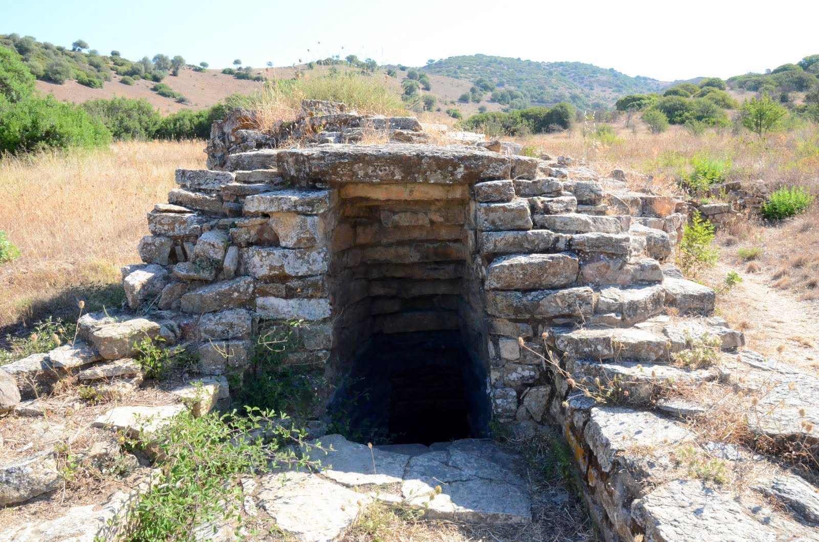
The Sacred Pit of Garlo is an underground archaeological complex near Garlo village in Bulgaria, assigned to the Late Bronze Age, the later part of the Bronze Age before ironworking became widespread. Its date and purpose remain disputed, while its unusual form has prompted comparisons with Sardinian sacred wells and debate about the origins of its building tradition. Bulgarian archaeologist Dimitrina Mitova-Dzhonova led its excavation in 1972.
Date and interpretations
Mitova-Dzhonova dated the structure to the 12th century BC. Other estimates place it broadly between the 12th and 10th centuries BC, while a separate proposal centers on the 11th century BC. A researcher studying possible astronomical alignments questioned an early date, pointing to the stone-vaulted construction, marks resembling Roman numerals, and the possibility that the structure was filled during Late Antiquity, the transition between the Roman era and the medieval world. Because archaeological investigation has been unsystematic, the building’s cultural and historical interpretation remains uncertain.
The excavators first considered the complex a burial monument, comparing it with domed tombs from Thessaly, a region of Greece. They abandoned that explanation after finding animal bones interpreted as sacrificial remains. Mitova-Dzhonova instead connected the structure with water-related worship and sacred wells associated with Sardinia’s prehistoric Nuragic culture, known especially for its stone towers and sacred wells. She proposed that the building tradition might have arrived with migrants, or that local people might have hired builders familiar with it. The structure has been described as unusual in Thracian settings, with no close parallel elsewhere in the Balkans.
Mitova-Dzhonova interpreted the pit as a sanctuary for Enki, a Mesopotamian deity associated with water, and linked it to Abzu, the subterranean freshwater realm in Mesopotamian belief. More generally, she understood the place as one for worship focused on underground water. In 2014, Sardinian prehistorian Giuseppa Tanda noted constructional similarities with Sardinian examples and considered a religious purpose likely. She did not determine whether Garlo’s structure was an analogue, or whether it came earlier or later.
Use and proposed alignments
Researchers have proposed several astronomical interpretations, but these do not provide a reliable way to date the building. An early idea linked light entering the chamber with the equinoxes. Later readings treated the structure as a possible marker of the winter solstice rather than a precise calendar instrument. An engineer also proposed a winter-solstice ceremony celebrating the birth of a new sun. A separate, highly speculative suggestion was that a parabolic mirror at the bottom of the well could have made the chamber work as a reflecting telescope.
A prehistoric settlement on the slope above the pit is considered contemporary with the complex and associated with the sanctuary. A small Roman bath about 150 metres to the east shows that the pit and bath existed alongside one another into Late Antiquity.
Excavation and modern history
Looters disturbed the structure in 1971, before the 1972 excavation. Conservation and restoration work in the 1980s substantially altered parts of the building and reduced its authenticity. A 2012 survey involving archaeologists, geophysicists, and other researchers aimed to improve understanding of the site. After 1989, institutional care was limited, and a protective shelter collapsed in 2008. Looting continued through at least the end of 2019, while private volunteers cleared vegetation to help protect the dry-stone walls. Cameras for continuous video surveillance were installed in 2020.
At the end of 2019, the site’s formal heritage status was unclear. Breznik Municipality’s website listed it as a monument of national importance, but the national heritage institute had no record of it. A proposed UNESCO World Heritage nomination was abandoned, and the site was not listed by UNESCO. Breznik Municipality and the Regional Historical Museum in Pernik managed the site.
Remains
The complex occupies a small valley with prehistoric springs on a steep mountain slope north of Garlo. It lies below a mountain peak, west of a river gorge, and on the eastern side of a hill above a reservoir built in the 1960s. Nine springs were identified on the mountain’s northeastern slope; the structure was built at the highest one. Partly cut into the ground, it is constructed from dry-stone masonry, with stones fitted together without mortar.
The underground complex
Approach, stairs, and chamber
A corridor about 7 metres long and a stone stairway descend to the circular chamber. The stairway is about 1.1 metres wide; its upper portion is open to the sky and its lower portion lies underground. An arched entrance, 2.4 metres high, connects the passage to the chamber, whose diameter is about 4.2 metres. A 5-metre-deep well sits at the chamber’s center, over the spring, with its long axis running north to south. Two opposing niches are set into the corridor walls.
Roof and construction
The chamber is covered by a hemispherical stone dome with a circular opening at its crown. The opening is about 2.3 metres across in its present form; Mitova-Dzhonova thought it may originally have measured about 1 to 1.5 metres. The corridor roof changes in form along its length. Large stone slabs cover its upper, trapezoidal section, while the lower part narrows into a triangular profile built with wedge-shaped stones and a central stone at the top. A stepped roof of large slabs covers the western section before the chamber entrance. The entrance arch and dome use the pressure of their stones to support their shape.
Alterations and damage
The present stairway does not preserve its original arrangement. Restoration added a 90-degree turn at the exposed upper end, taking the stairs from about 1.5 metres below ground level to the surface. The earlier layout cannot now be recovered. In 1971, looters removed a roof slab about 1 metre thick, exposing an opening roughly 1 metre across, and took a stone from the wall base where the stairway meets the chamber. The corridor later became crooked, and the slab above the passage-to-chamber arch cracked. Looters also broke up the western part of the chamber floor, while restoration in the 1980s enlarged the dome opening.
Light and carved marks
A horizontal stone that once closed the corridor roof, now cemented in place, has featured in proposed astronomical readings. Documentation from 1983 placed it 8.8 centimetres lower than its present position. The light it casts across the floor at the chamber entrance leaves dark strips estimated at 4 to 5 centimetres wide on either side. The stone tilts inward and may have shifted during earthquakes; when excavated in 1972, it appeared displaced outward and downward, although the amount of movement is unknown.
On the wall opposite the chamber entrance, a thin carved line marks a stone set above a projecting stack of slabs that differs from the surrounding horizontal courses. This arrangement has been interpreted as a possible marker for the winter solstice or for the Moon at its minimum declination. Five other marks, each about 2.5 to 5 centimetres high, appear 1.8 metres above the floor to the right of the entrance. They resemble the Roman numerals V and VI, though the stone receives no direct sunlight. The widening of the steps toward the chamber has also been read as a possible way to track intervals of about 15 days. Restoration and the movement of structural elements make these interpretations difficult to verify.
Objects and animal remains
A pottery fragment found outside the entrance was considered eastern in character by Mitova-Dzhonova. A fragment from a brown glass cup was recovered 4 metres down in the well, beneath rubble and earth. It is 4.5 centimetres across and dates to Late Antiquity; it may relate to the structure’s filling in the 4th or 5th century AD. At the bottom of the well, excavators also found part of a stone axe or ploughshare point, along with roughly worked oak pieces and twigs. Their split and sharpened surfaces were considered consistent with work using stone tools, and Mitova-Dzhonova regarded them as evidence of ritual activity.
Animal remains came from beside the corridor’s south wall, outside the chamber entrance, and within the chamber. The corridor finds included calf and cattle leg bones, horns, and part of a horned bull’s skull. The chamber contained remains of three kinds of dog, a wolf, a bull, wild and domestic cats, a fox, a hare, and a freshwater turtle. Mitova-Dzhonova interpreted the corridor material as offerings to a deity and the chamber animals as symbolic remains left after a final offering.
During conservation work in the mid-1980s, Mitova-Dzhonova found part of a ceramic tablet bearing signs identified as Sumerian cuneiform, a wedge-shaped writing system. She published the fragment in 2012, but its surviving signs have not been analysed.
Surrounding remains
Sanctuary and standing stones
A sanctuary stood directly above the pit. Local residents recalled carved signs or drawings on the surrounding rock, as well as a small stone basin near the well. The basin was made from four blocks and remained in place until around 1970. About 700 to 800 metres to the northwest, a cemetery locality had a row of rough standing stones, which were later destroyed. Mitova-Dzhonova interpreted these features as parts of a wider complex associated with lunar worship.
Prehistoric settlement
Stone debris resembling the pit’s building material was noted higher on the mountain’s northwestern slope and considered possible evidence of a settlement. On the eastern slope above the river, fragments of thick-walled, coarse grey-black pottery included open bowls decorated with incised designs filled with white paste. These finds date the settlement to the Late Bronze Age. The area is now wooded, making the settlement’s extent difficult to determine.
Roman bath
A small Roman bath lies about 150 metres east of the pit and was supplied by groundwater. An intake for the village water system is near the bath.