Duneau Archaeological Site: A Prehistoric and Gallo-Roman Settlement in France
Site at a Glance
- Popularity
- Very Low
- Country
- France
- Primary era
- Classical
- Eras represented
- Stone Age, Iron Age, Classical, Medieval
- Civilizations
- Hallstatt culture, Merovingian, Roman
- Site type
- City
On this page22 sections
History
The Duneau archaeological site is a multi-period archaeological landscape in Pierrefiche, within Duneau, France. Its history reaches from Neolithic occupation through the Iron Age, the Roman period in Gaul, and the early Middle Ages. During the Roman Empire, settlements in the Huisne basin, including Duneau, Connerré, and Sceaux-sur-Huisne, appear to have formed one of two principal centers for distributing Sarthe ceramics, alongside the La Bosse and Allonnes group.
Prehistoric and Iron Age activity
Neolithic occupation marks the earliest known phase at Duneau. Later activity belongs to the Hallstatt and La Tène periods, successive cultural phases of the European Iron Age, but it appears to have been limited.
Roman settlement and medieval reuse
A Roman road crossed the area, connecting Vindunum, now Le Mans, with Autricum, now Chartres. The route remained in use during the Middle Ages. Its presence has led to the suggestion that Duneau may have been a vicus, a secondary settlement in the Roman world. The Roman-period settlement also formed part of a wider network of communities associated with the distribution of Sarthe ceramics.
Early medieval fortification and Duneau’s name
Duneau is associated with the Merovingian period, named for the early medieval Frankish ruling dynasty. An oval fortification on the Châtellier plateau, overlooking the Huisne, was probably built during the Early Middle Ages. The place-name appears in the Latin form Dunellum in 1010. Proposed explanations connect it either to a Latinized Gaulish dunum with the suffix -ullum, interpreted as “fortified enclosure,” or to a word for a fort or circular stronghold and the Latin idea of a fortified settlement.
Archaeological investigations
André Ledru uncovered a coin deposit on the Châtellier plateau in 1830, and another was found at Marcé in 1860. In 1889, the menhir La Pierre Fiche and the dolmen La Pierre Couverte were classified as French Historic Monuments. Roadworks in 1895 accidentally revealed an ancient road near Bouvières and Bouverie. Samuel Menjot d’Elbenne excavated there in 1896, finding remains of the Roman-period route, a medieval enclosure, ruins, and artifacts.
In 1907, local schoolteacher G. Bois discovered another coin hoard. From 1921 to 1923, he probed fields at La Vigne and La Vigne-aux-rats, exposing a stretch of ancient road; Menjot d’Elbenne published an account in 1923. Preventive excavations at Les Vignes in 1979, followed by further work in 1984, revealed additional remains. In the early 1990s, archaeologist C. Gaillard investigated the town-hall square, with a report published in 1993. Excavations that year also revealed house and public-building ruins.
Claude Lambert and Jean Rioufreyt carried out further research in the late 1990s and published a synthesis of earlier investigations in 2001. In 2007, Gérard Guillier led a preventive excavation on the Châtellier plateau with a team from France’s National Institute for Preventive Archaeological Research. The excavation confirmed the presence of an ancient secondary settlement with a fortified enclosure.
Remains
The archaeological area lies on the left bank of the Huisne, at elevations between 62 and 133 metres. It extends south and southeast of Duneau’s outskirts and into their western margins. The Huisne borders it to the west, the Dué runs along its southwestern side, and the Quellerie stream bounds the area as it crosses Luard. The remains include unworked-stone megaliths, traces of roads and buildings, water installations, craft features, and earthwork enclosures.
Neolithic megaliths
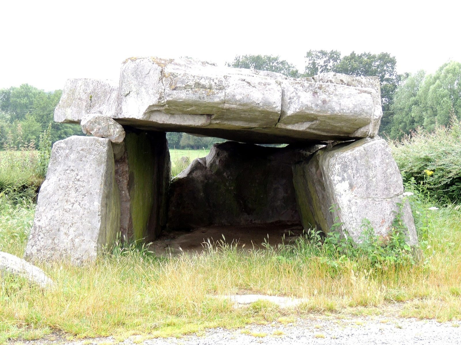
La Pierre Couverte
La Pierre Couverte is a dolmen, a megalithic structure formed from large stones, built from unworked blocks and classified as a regional Angevin-type dolmen. Its alignment is associated with lunar declination, the Moon’s position north or south in the sky. The same axis extends toward La Pierre Fiche and passes through a hole in that stone.
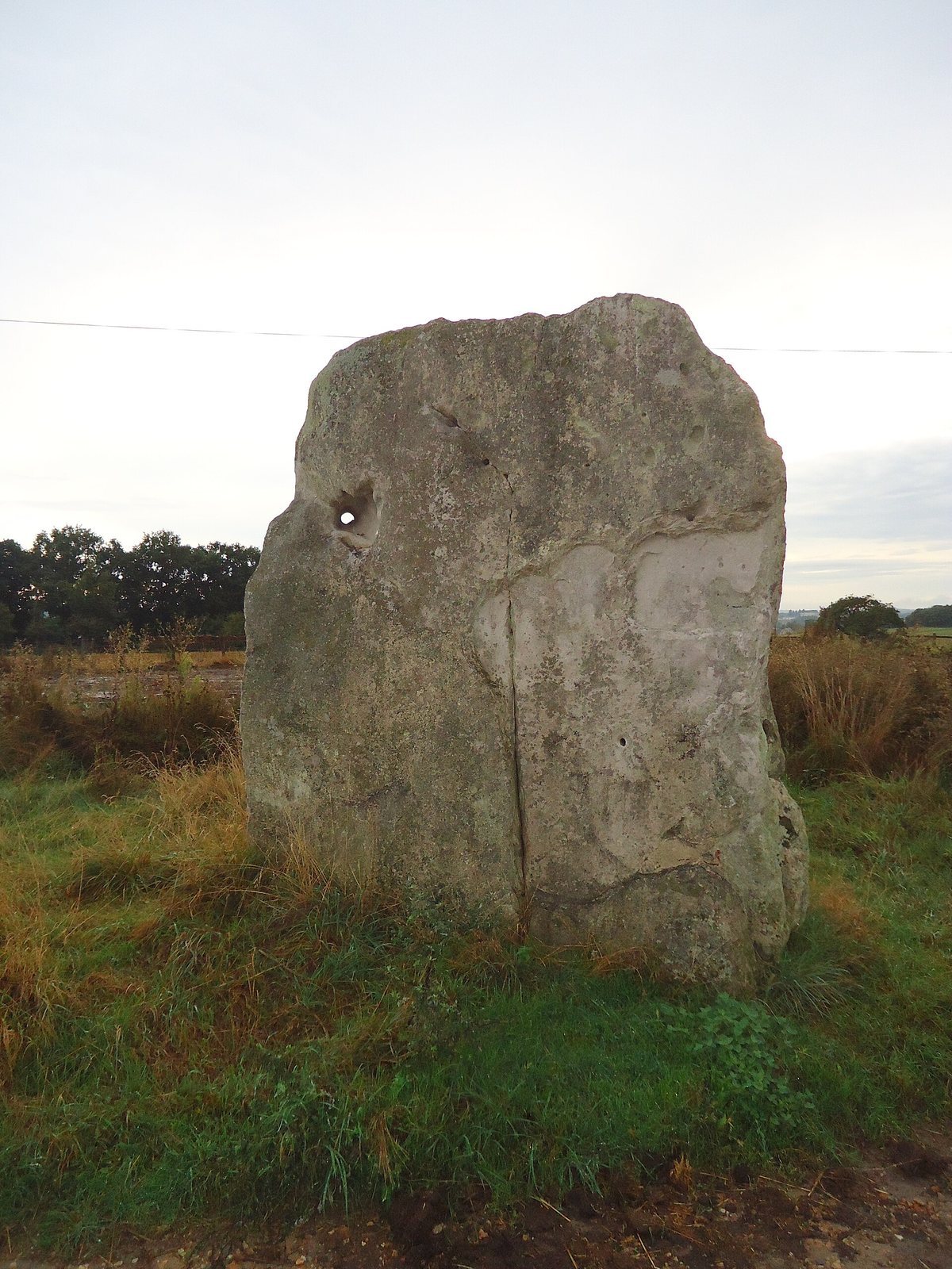
La Pierre Fiche
La Pierre Fiche is a menhir, or standing stone, and is the nearby counterpart to the dolmen. The hole through the stone lies on the axis associated with the dolmen’s alignment.
Roman roads and settlement
Road near Bouvières and Bouverie
A stretch of the ancient road was found near Bouvières and Bouverie, close to a departmental road serving, among other places, Vouvray-sur-Huisne. Surveys along the remains recovered coarse black and gray pottery fragments, clinker, animal remains, and pieces of flint.
Lane on the Châtellier plateau
Nine trenches exposed a small lane in the upper layers of the La Vigne and La Vigne-aux-rats fields, southeast of the enclosure. It is estimated to have been 3 to 4 metres wide. Some stretches were laid with limestone pieces, occasionally set on edge; others consisted of slag and were sometimes level with the water table. Its date remains uncertain, although Menjot d’Elbenne identified the excavated stretch as a Roman-period street and estimated that it ran east to west for 175 metres.
Cistern and paved area
The same fields contained a cistern and a paved surface 1.12 metres below ground. The paving was made of sandstone slabs estimated to be 2.50 metres long. A section was covered by a low wall, about 0.25 metres high, built from mortar-bound rubble and topped with red bricks. The wall was 1.20 metres long and 0.25 metres wide. Metallurgical debris from a forge and a coin bearing the image of Trajan were also found in these fields.
Roman-period buildings and production
Villa at the Pressoir field
Nineteenth-century excavations at the Pressoir field exposed a Roman villa. Its surviving lower walls and paving tiles lay among deposits containing common pottery, fine Roman tableware called terra sigillata, and terracotta architectural decoration. Finds recovered in the area in 1993 included fine terra sigillata and additional terracotta ornaments.
Pottery workshop at Champs du Quellousier
A Roman-period potters’ workshop was identified at Champs du Quellousier in the late 1990s. Its finds included a round, fragmentary pottery kiln, jugs, and painted ceramics. The kiln’s firing floor rested on a central masonry projection within a masonry enclosure. Excavations in 1993 also revealed workshop structures, including a reconstructed four-step staircase and a tiled floor made from limestone and fused slag.
Water installations near Maison du Gué
A few metres from the Quellousier area, near the agricultural barn called Maison du Gué, archaeologists found wells with masonry interiors. Behind the barn, a fountain was supplied by a spring held in a tunnel-shaped reservoir. The ancient water system cannot be dated more precisely; its conduit is estimated to have been 20 to 25 centimetres wide. Nearby vats probably served a tannery.
Finds at Champ Saint-Cyr
Excavations at Champ Saint-Cyr recovered coins of the emperors Vespasian and Trajan, a lead wheel-shaped object, and both common pottery and terra sigillata. Some drinking vessels, chiefly jugs, had yellowish fabric and bore the stamp “ARA VICTORIXE.” Other finds included rubble stones, bricks, roof tiles with raised edges, terracotta pipes, sandstone slabs, nails, hooks, and gouges.
Fortifications and enclosures
Châtellier plateau
The plateau contains an area of Roman-period occupation with a street network and a public building. An oval fortification overlooking the Huisne is probably early medieval. Its form and position relate to the wider sequence of settlement and enclosure on the plateau.
Enclosure at Montferré
At Montferré, excavations in the second half of the 1970s exposed a quadrangular enclosure formed by an earth bank about 1.50 metres high. Archaeologist A. Ledru had noted the feature in a report published in 1911.
Coin deposits
The hoard found in 1907 was held in a black vessel and initially counted as 7,353 bronze coins, weighing nearly 13 kilograms. Most were antoniniani, a Roman coin denomination, or imitations. The coins bore images of Gallienus, Salonina, Claudius II, Quintillus, Aurelian, Probus, Quietus, Postumus, Victorinus, and Tetricus I and his son Tetricus II. About 85 percent appear to have been imitations of Roman coins, probably made in local workshops.