Opochka Fortress: A Medieval Southern Frontier Stronghold
Site at a Glance
- Popularity
- Low
- Country
- Russia
- Primary era
- Medieval
- Eras represented
- Medieval
- Civilizations
- Pskov Republic
- Site type
- Military
- Remains
- Citadel
On this page16 sections
History
Opochka Fortress is a medieval stronghold in Opochka, Russia, built by Pskovians in 1414 as the principal southern defense of the Pskov lands. Pskov masters and workers from the surrounding area completed it in two weeks, from 24 September to 7 October. Its name is linked to local limestone deposits called opoka.
Foundation on the southern frontier
The fortress took over the role of the frontier center after forces of Vytautas, ruler of the Grand Duchy of Lithuania, destroyed the earlier stronghold of Kolozhe in 1406. Opochka was chosen for its more defensible position and apparently stood on the site of an older fortified settlement. Pskov chronicles described the new foundation as the city of Kolozhe established at Opochka.
In 1426, during another campaign by Vytautas, defenders dropped a rope-supported bridge as attackers crossed it. The men fell into the moat onto sharpened stakes. The city was completely destroyed by fire on 5 September 1441, then rebuilt that autumn under Timofei Vasilyevich Potkin, a posadnik, or senior civic official. The reconstruction appears to have established the fortress’s main layout.
Under Moscow and the sixteenth-century wars
After Pskov became part of Moscow’s lands, Opochka remained a fortified outpost with a standing garrison led by a governor and a voivode, a regional official with military duties. In the 1510s and 1520s, Habsburg diplomat and imperial envoy Sigismund von Herberstein described a wooden fortress above a large settlement.
The stronghold repelled a joint Lithuanian and Livonian assault in 1502, then resisted a major Lithuanian army in 1517. The attackers, commanded by Konstanty Ostrogski, faced stones, rolling logs, and objects suspended above the defenses to strike men climbing assault ladders. The failed campaign ended efforts by Vilnius to gain revenge during the Russo-Lithuanian War of 1512 to 1522.
Church building followed the successful defense. In the fortress and its settlements, churches were dedicated to Sergius of Radonezh, a revered medieval monk, Saint Paraskeva Pyatnitsa, the Apostle Thomas, and the Evangelist Luke, alongside an existing Church of the Savior. The town also expanded across both banks of the Velikaya River.
During the Livonian War, a sixteenth-century conflict involving Russia and neighboring powers, Opochka supplied weapons and grain to the southwestern front. In 1562, a defensive line of stakes helped protect its settlement from a Lithuanian attempt to burn it. Stephen Báthory, king of Poland and grand duke of Lithuania, blockaded Opochka during his 1581 campaign against Pskov but did not capture it. The Treaty of Jam Zapolski included Opochka and Sebezh among the towns the attackers had failed to take.
Outer defenses and seventeenth-century conflict
Land-survey registers from 1585 to 1587 described Opochka as a wooden town on an island. They listed the governor’s and voivode’s compounds, quarters for service personnel inside the fortress, and extensive surrounding settlements, some partly abandoned. During the Time of Troubles, the early seventeenth-century period of political crisis and warfare in Russia, the fortress repelled attacks, including one associated with Polish-Lithuanian commander Alexander Lisovsky. It became the main strongpoint of the southern frontier line, supported by service personnel from the fortified towns of Velye, Voronich, and Krasny.
By royal order, construction began in 1629 and 1630 on a new defensive enclosure around the settlement, known as an ostrog, or timber-fortified outer town. The work was organized by Ignaty Kharlamov and the Opochka voivodes Ivan Nashchokin and Vasily Turov. Residents resisted moving their yards inside the new defenses, preferring to keep their homes outside and burn them if war came.
Opochka also withstood Polish-Lithuanian attacks during the Smolensk War, a conflict between Russia and the Polish-Lithuanian Commonwealth, the state formed by the union of Poland and Lithuania. A defense in 1634 is recorded. A major fire in 1648 destroyed the outer town and some weapons; reconstruction used local resources under state supervision.
During the Russo-Polish War of 1654 to 1667, the fortress survived a siege in 1664. It continued to hold a permanent garrison and large supplies of gunpowder, lead, and iron cannonballs. Although the 1667 Truce of Andrusovo, an agreement between Russia and the Commonwealth, moved the frontier west, Opochka remained a military and supply center into the late seventeenth century, and its defenses were further modernized.
Decline as a fortress
Opochka’s military role waned during the eighteenth century. After the first partition of the Polish-Lithuanian Commonwealth, it was chosen as a provincial capital in 1772. A proposed plan for an ideal provincial city followed in 1774 but was not implemented. That year, a major fire destroyed the wooden fortifications.
By the end of the century, the fortress no longer served a defensive purpose, and its grounds were incorporated into the city plan. Opochka Fortress is designated a federal-level cultural heritage site of the Russian Federation.
Remains
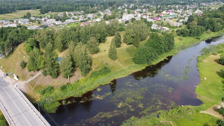
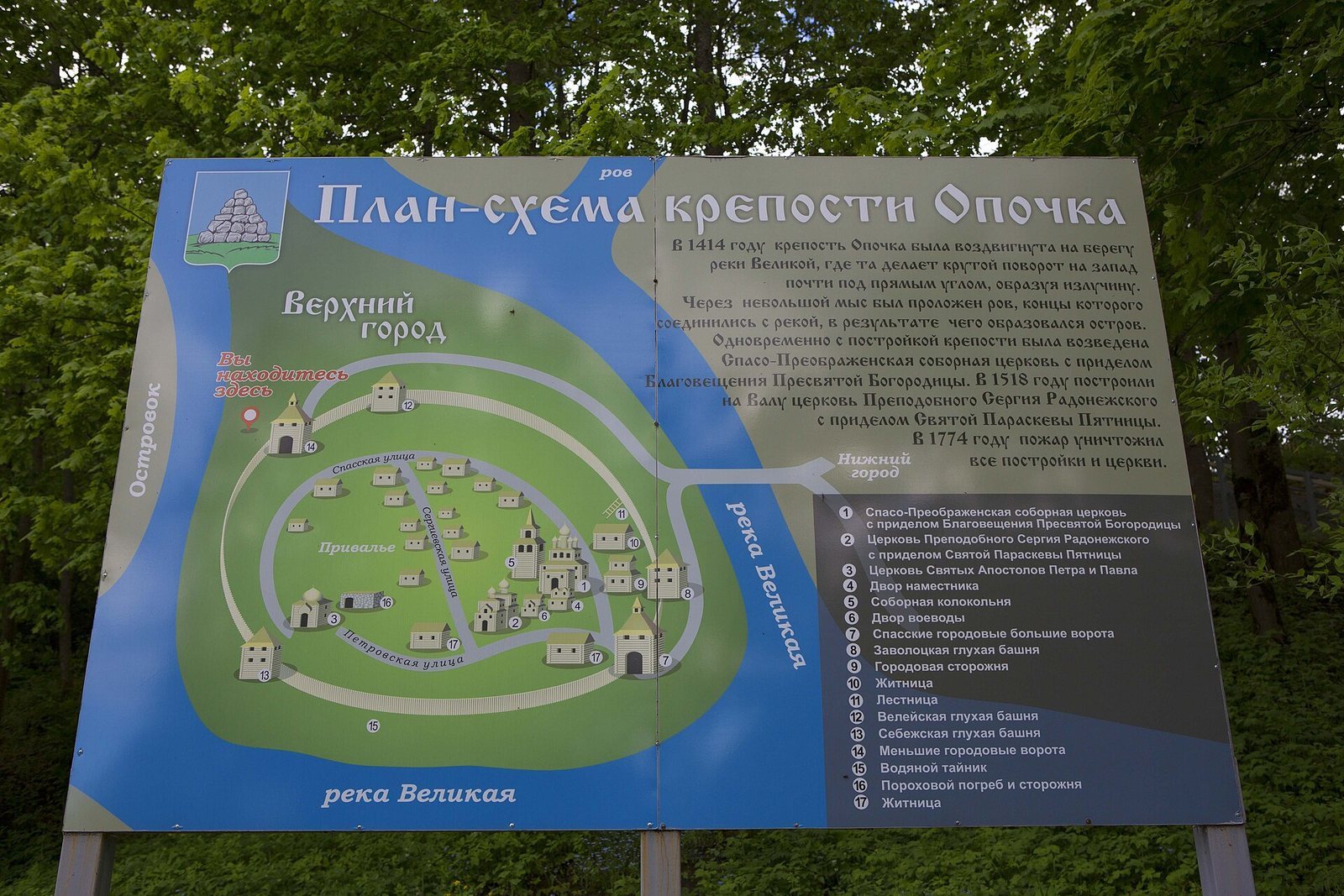
The fortress occupied an elongated, elliptical hill of limestone in a bend of the Velikaya River. The river bordered the site on three sides; a cut channel joining the ends of the bend and a water-filled moat enclosed the fourth, creating an artificial island. The moat later became the river’s main channel. The Upper Town covered about 1.5 hectares, with walls around 500 metres long and a perimeter of roughly 750 metres.
Upper Town defenses
The site’s surviving ramparts rise up to 4 to 5 metres, and the outline of the Upper Town remains partly legible. The area is locally known as the Val.
Ramparts and walls
The ramparts originally reached 15 to 20 metres in height. Along them stood timber-and-earth walls made from two rows of upright logs packed with earth and stone. A palisade above the walls included a protected fighting passage and openings for weapons. Timber towers without gates and artillery platforms stood against the inner face of the defenses. The earth-filled construction was considered less vulnerable to cannon fire.
Gates and towers
The fortress had two gates. The Great Gate, later called the Spassky Gate, faced southeast, while the Small Gate stood to the northwest. A descent from either gate led to a crossing of the moat, initially made by a suspended rope-supported bridge. Sixteenth- and seventeenth-century descriptions name three towers: Zavolotskaya to the south, Sebezhskaya to the west, and Veleyskaya to the north beside the Small Gate. The first two stood on either side of the Great Gate on the southern slope.
Buildings and streets within the Upper Town
Churches and civic compounds
The higher eastern ground held the principal churches and administrative compounds. Near the Great Gate stood the Cathedral of the Transfiguration, named for the Christian episode in which Jesus was revealed in divine glory to his disciples, together with its bell tower. The governor’s and voivode’s compounds, service yards, siege quarters, musketeers’ quarters, barns, and granaries were mostly wooden. The powder magazine and some separate utility buildings were built of stone.
Streets and service areas
Great Spasskaya Street curved around the hilltop between the two gates. Three main streets crossed the fortress: Spasskaya, Sergievskaya, which followed the rampart from north to south, and Petrovskaya in the southern area. Squares lay beside the churches of the Savior, Peter, and Sergius. Rows of siege quarters, cellars, closets, and state granaries occupied the slopes, including ground near the powder magazine. An underground passage carried water from the Velikaya beneath the fortress wall.
Moat, bridge, and surrounding settlements
River crossing
A floating wooden bridge, about 57 sazhen long, connected the fortress with settlements across the Velikaya moat. A sazhen was a traditional Russian unit of length. The settlements spread along both riverbanks and beyond the river, producing an almost ring-shaped town plan.
Lower Town and outer defenses
Beyond the Upper Town, fortified settlements and the outer town developed on the right bank of the Velikaya. Its defenses grew from palisades and rows of stakes into log walls, towers, and gates linked with roads toward Polotsk, Voronich, Pskov, and Sebezh. By the middle of the seventeenth century, the outer town had Nikolsky, Spassky, and Pskov gates, artillery positions, and further towers along the Voronets and Polotsk roads, arranged to cover approaches to the settlement.
Artillery and supplies
The fortress held both heavy and light guns, including types known by the period labels one-and-a-half and forty, as well as falconets, small light cannon, wall guns, and handguns. Its ammunition and stores included iron cannonballs of different sizes, shot, lead, and gunpowder. Heavy artillery was positioned in both the Upper Town and the outer town.