Phimai Historical Park: A Khmer Urban and Temple Complex in Thailand
Site at a Glance
- Rating
- 4.6
- Popularity
- Medium
- Country
- Thailand
- Primary era
- Medieval
- External website
- Open
- Eras represented
- Medieval, Early Modern
- Civilizations
- Unclassified
- Site type
- Religious
- Remains
- Sanctuary
On this page21 sections
History
Phimai Historical Park is an ancient Khmer urban and temple complex in Nakhon Ratchasima Province, Thailand, built mainly between the late eleventh and twelfth centuries in the Khmer architectural tradition. It preserves the ancient city of Phimai and Prasat Hin Phimai, a temple that became an important Mahayana Buddhist center and formed part of the regional administrative and communications network of the Khmer Empire.
Vimayapura and the Khmer road network
The ancient city was known as Vimayapura, a name preserved in Khmer inscriptions and regarded as the origin of the Thai name Phimai. Its rectangular plan followed Khmer principles of urban design. Situated beside the Mun River, the city connected communities in the Chi and Khong basin, northern Laos, and the Khmer heartland to the south.
An inscription dated 1082 at nearby Prasat Phnom Wan names Vimayapura and refers to Jayavarman VI. Another inscription, at Preah Khan near Angkor and dated around 1191, places Vimaya on an imperial road and mentions seventeen rest houses along the route from Angkor. The temple’s unusual southern orientation reflects this connection, since its main axis follows the ancient road toward Angkor, approximately 225 kilometres away.
Temple development and religious change
Construction of Prasat Hin Phimai probably began during the reign of Suryavarman I in the late eleventh century. Later additions and alterations are associated with the reigns of Jayavarman VI, Dharanindravarman I, Suryavarman II, and Jayavarman VII. The sanctuary is thought to have begun as a Brahmanical foundation before being converted or adapted for Mahayana Buddhism under Jayavarman VII. Evidence also indicates that Mahayana Buddhism already had an important place in the region before the principal Khmer building phases.
The complex combines artistic characteristics associated with the Baphuon, Bayon, and Angkor Wat periods. Its scale, its place on the road to Angkor, and its role in the regional administrative network helped make Phimai an important Khmer center. It is also regarded as the largest ancient Mahayana Buddhist temple in Thailand.
Decline, political reorganization, and later use
Phimai gradually lost importance after the decline of Khmer cultural influence following the reign of Jayavarman VII and the rise of the Sukhothai Kingdom. The city eventually disappeared from the historical record for the Sukhothai period.
After Ayutthaya fell in 1767, Prince Kromamuen Thepphiphit attempted to establish Phimai as the capital of one of several successor states. He was defeated and executed in 1768. Later religious and architectural remains at Phimai are associated with this period of political reorganization, including structures connected with the adoption of Theravada Buddhism.
Rediscovery and conservation
The ruins were first inventoried in 1901 by the French geographer Etienne Aymonier. The Thai government placed the site under protection in 1936. Most restoration took place from 1964 to 1969 through a Thai-French project that used anastylosis, a method of reassembling surviving architectural elements to reconstruct a monument’s documented form. Phimai Historical Park formally opened in 1989.
Excavations begun in 1998 by the Origins of Angkor Project examined the city’s underlying layers and construction sequence, including deliberate deposits of fill made during the Angkorian period. Phimai also served as a base for excavations at Ban Non Wat. The Fine Arts Department, under Thailand’s Ministry of Culture, manages the historical park.
Remains
Phimai lies on the eastern side of the Mun River and covers approximately 115 rai. The principal planned area is described as a rectangle about 565 metres wide and 1,030 metres long, while the ancient urban enclosure measures approximately 1,020 by 580 metres. The city occupied naturally protected ground near a bend of the Mun River and Khlong Chakrai. A laterite wall and moats supplied by the river enclosed the settlement and also formed the outer boundary of the temple complex.
City enclosure and temple approach
Gates and galleries
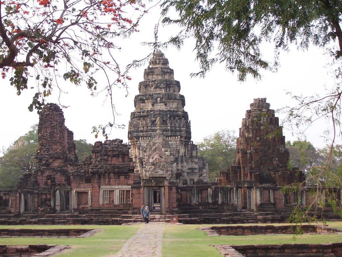
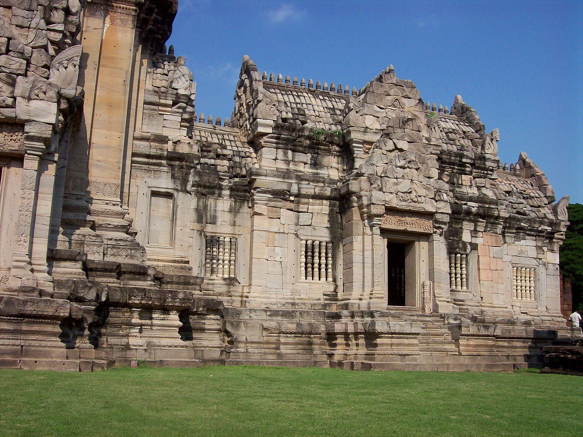
Prasat Hin Phimai follows a cruciform plan, with monumental gateways and galleries on its four sides. A gopura, or temple gateway, stands within each side of the surrounding enclosure. The northern and southern gateways occupy the centers of their walls, while the eastern and western examples lie slightly north of center. Each gateway and its surrounding plan is cruciform.
The temple faces south rather than east, as most Khmer sanctuaries generally do. Its southern axis follows the ancient route toward Angkor. The southern entrance, known as Pratu Chai or the Victory Gate, opens toward the approach to the central sanctuary.
Silver Treasury pavilion
A rectangular pavilion stands in front of the outer wall, to the left of the entrance path. Formerly called the Silver Treasury, it may have provided a preparation and resting place for kings or high-ranking officials attending religious ceremonies and may also have been used to arrange offerings. Excavation in 1968 uncovered images, ornaments, bronze coins, and other antiquities there.
Naga Bridge and southern walkway
The southern Naga Bridge stands before the southern gateway. Built of sandstone, it is about 4 metres wide and 31.70 metres long, with a cruciform plan raised above the surrounding ground. Its balustrades take the form of nagas, serpent beings associated with water, protection, and passage between cosmic realms. The balustrades end in seven-headed serpent figures, giving the bridge a symbolic role as the route from the human world toward the heavenly realm and Mount Meru. Two large guardian lions stand at the bridge steps.
A raised sandstone walkway leads from the southern gateway to the gallery around the central sanctuary. About 1 metre above ground level, it is divided into three passages and follows a cruciform arrangement. Roof-tile fragments and numerous terracotta finials found during restoration indicate that it was once an open gallery with a tiled roof supported by wooden posts.
Central sanctuary
Principal tower and mandapa
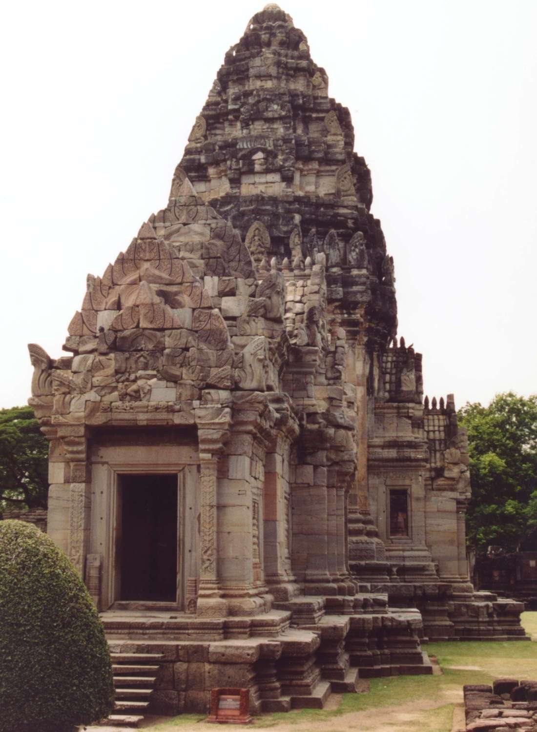
The central sanctuary is built of white sandstone and is generally dated from the eleventh to the twelfth century. Its principal tower rises about 28 metres. The structure consists mainly of a mandapa, or antechamber, and the tower body. The mandapa projects to the south, an unusual arrangement in Khmer architecture, and links the southern enclosure with the main tower.
The square tower has indented corners and projecting porches on its sides. It rises from a raised double platform, and its exterior is carved with foliage, diamond patterns, and lotus flowers. Lintels, the horizontal stones above doorways, and pediments, the decorated upper sections above entrances, carry scenes from the Ramayana and Buddhist narratives. The southern side contains an image of Shiva Nataraja, the dancing form of the Hindu god Shiva.
Sacred chamber and ritual drainage
The innermost chamber, or garbhagrha, was the sanctuary’s most sacred space and housed important images. A copy of a Buddha protected by a naga was placed at its center. In the northeastern corner, a channel called a somasutra passes through the floor and leads outside. It carried away lustral water used in ritual ceremonies.
Visible outer surfaces were principally made from sandstone, while laterite served for foundations, inner walls, and concealed structural elements. Khmer builders used large sandstone blocks and cut the ends of lintels at approximately 45-degree angles so that they fitted into the surrounding masonry.
Secondary towers and religious buildings
Red Stone Tower
Prang Hin Daeng, or the Red Stone Tower, stands west of the principal sanctuary. This square prang, or Khmer-style sanctuary tower, is approximately 15 metres high and is generally dated to the late twelfth century, during the reign of Suryavarman II. Projecting porches extend from all four sides. The northern entrance lintel shows Arjuna hunting a wild boar from the Mahabharata, while the other doorways retain decorated door-jambs.
Brahmadat Tower and sculptures
Prang Brahmadat is a square laterite tower approximately 16 metres high in the inner complex. Its construction is associated with the restoration of Phimai under Jayavarman VII. A seated stone figure traditionally called Brahmadat was found during exploration in 1954. The damaged statue lacks its arms and has been interpreted as a possible representation of Jayavarman VII. A second damaged kneeling female figure, traditionally identified as Nang Oraphim and associated with Queen Jayarajadevi, has lost its head and arms. Both sculptures are displayed at the Phimai National Museum.
Brahmin Hall and libraries
The Brahmin Hall is built of sandstone and laterite and shares a base with the Red Stone Tower. Seven sandstone lingams were found inside it in 1950. The building may have been used for Brahmanical ceremonies, although its form and position have also led to its interpretation as a former library.
Two similar rectangular library buildings stand on the western side of the outer court, between the outer wall and the entrance to the gallery. Raised on platforms and built of sandstone, they are divided into long internal rooms. Square postholes show where wooden roof supports stood, and the roofs probably carried tiles. Their traditional interpretation is as repositories for sacred religious manuscripts.
Later structures and archaeological collections
Courtyard gallery and associated buildings
A small rectangular gallery surrounds the courtyard and has been rebuilt. It contains Buddhist inscriptions and small sculptures, including a pre-Angkorian inscription recounting the life of Prince Siddhartha Gautama and other Buddhist narratives.
Four ponds at the corners of the outer enclosure once formed parts of four temples. They are associated with the period after the fall of Ayutthaya, when Kromamuen Thepphiphit established his capital at Phimai. Kuti Rishi, or the Rishi quarters, is also listed among the associated structures of the park.
Bot Chao Phimai was probably constructed in the late Ayutthaya period near the western gateway and library buildings. It was later moved north of the Prasat Hin Phimai complex. The building contained gilded Buddha images and furniture holding late-Ayutthaya manuscripts.
Meru of Brahmadat
The ruins of the Meru of Brahmadat lie southeast of Prasat Hin Phimai. This stupa was built during the occupation associated with Kromamuen Thepphiphit, after Phimai had adopted Theravada Buddhism.
Museum collections
The Phimai National Museum preserves Buddhist and Khmer architectural elements recovered from Phimai and related monuments. Its collections include carved lintels, Buddha images, naga figures, guardian figures, Ramayana scenes, and decorative pieces in Baphuon, Bayon, and Angkor Wat styles. An eleventh-century sandstone lintel measuring approximately 3 by 1.5 metres is also preserved there. Its scene may represent a king’s funeral rite and the transport of a soul by a naga, although that interpretation remains uncertain.