Gunung Susuru Site: The Traditional Center of Galuh Kertabumi

Site at a Glance
- Rating
- 4.3
- Popularity
- Low
- Country
- Indonesia
- Primary era
- Stone Age
- Eras represented
- Stone Age
- Civilizations
- Unclassified
- Site type
- Religious
- Remains
- Sanctuary
On this page15 sections
History
Gunung Susuru Site, associated with the remains of Galuh Kertabumi, lies in Kertabumi, Ciamis Regency, West Java, Indonesia. Also called Pasir Susuru or Bojong Susuru, it occupies a raised hill between the Cimuntur and Cileueur rivers. Local tradition places the establishment of Galuh Kertabumi in the late sixteenth century, when Rangga Permana founded his center of power here after receiving the territory as a marriage gift.
Galuh Kertabumi and its royal traditions
One tradition traces the foundation of the settlement to Putri Tanduran Ageng, daughter of Sanghyang Cipta, the ruler of Galuh Salawé. After her marriage to Rangga Permana, a relative of Prabu Geusan Ulun of Sumedang Larang, the territory was assigned to Rangga Permana to govern. Its population still followed Hinduism at that time. Rangga Permana established his seat at Gunung Susuru beside the Cimuntur River and became known as Prabu Di Muntur. He was enthroned in 1585 and ruled until 1602, when his son succeeded him under the names Sang Raja Cita, Wiraperbangsa, or Singaperbangsa.
Another tradition presents Galuh Kertabumi as a vassal kingdom of Galuh Pangauban, founded by Prabu Haur Kuning of Putrapinggan near Kalipucang. This account places the kingdom’s development within a long period traditionally dated from approximately 150 to 1580. Prabu Haur Kuning is also said to have sought a refuge beyond Cirebon’s reach, where he could establish a successor to Pajajaran and restore Galuh’s influence.
Genealogical traditions connect Prabu Haur Kuning with three sons. Maharaja Upama inherited Galuh Pangauban, Maharaja Sanghyang Cipta established Galuh Salawé at Cimaragas, and Saresepan Agung ruled at Cijulang. Sanghyang Cipta’s children are named as Tanduran Ageng, Cipta Permana, and Sanghyang Permana. Cipta Permana founded Galuh Kawasan at Banjarsari, while Sanghyang Permana continued the Galuh Salawé line with the title Prabu Di Galuh.
Political change and the spread of Islam
The traditions surrounding Galuh Kertabumi belong to a period of political change in western Java. Galuh’s ruler Jayaningrat moved from Kawali to Rajagaluh before conflict developed with Cirebon. A force associated with Pakungwati, Demak, and Kuningan is said to have campaigned against the remaining Galuh forces at Talaga. By 1531, Galuh had come under Cirebon’s authority, followed by an agreement recognizing mutual sovereignty between Prabu Surawisesa and Sunan Gunung Jati, the leading Islamic ruler and religious figure associated with Cirebon’s expansion.
The foundation of Galuh Kertabumi is linked to the spread of Islam from Cirebon and Sumedang into Galuh. Family connections, awareness of Islam’s growing influence, and the activity of Muslim scholars are said to have shaped Prabu Haur Kuning’s decision not to resist. Rangga Permana is described as the first Muslim ruler in the Galuh region, and his rule contributed to the expansion of Islam around Kertabumi.
Traditions differ over Rangga Permana’s relationship to Prabu Geusan Ulun. Some describe him as Geusan Ulun’s son, while a Sumedang genealogy identifies him as the son of Kyai Rangga Haji and therefore Geusan Ulun’s nephew. The same genealogy identifies Kyai Rangga Haji as a son of Pangeran Santri and Ratu Pucuk Umun. After Rangga Permana’s death, his body was placed in the Ciputrapinggan River and carried by boat toward the southern sea at Pangandaran in a Galuh funerary ritual called nerebkeun.
Place-name traditions and continuing observance
The name Susuru comes from a thorny plant traditionally used for fences. According to local tradition, susuru formed part of the ornamental fencing around the Galuh Kertabumi palace. The plants once grew widely at the site, but they were removed when the land was cultivated for corn in 1960. The soil remained productive for about fifteen years and had become barren by 1975.
The tomb of Nyi Tanduran Sari, described as Prabu Di Muntur’s concubine, lies near an old settlement and market area where large quantities of ceramics and pottery have been found. Prabu Di Muntur’s tomb is about 2 kilometers from Gunung Susuru. The Merlawu tradition is said to have continued since 1535 as a legacy of Galuh Kertabumi. Held on the final Monday or Thursday of Rewah, it combines offerings, historical narration, harvest thanksgiving, and the cleaning of the sacred punden stones, followed by cultural performances under the direction of the site custodian.
Remains
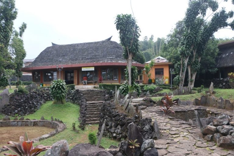
Gunung Susuru occupies a pasir, or raised hill, rather than a mountain. Its terraces extend between the Cimuntur and Cileueur rivers across terrain formed from weathered volcanic deposits. Alternating breccia, lava, tuff, and lahar layers produced thick red lateritic soil, a strongly weathered tropical earth rich in iron oxides. The physical remains include a 17-level punden complex, stone monuments, artificial caves, defensive-wall remnants, wells, a sarcophagus, and objects associated with prehistoric and later activity.
Terraced ritual complex
The punden complex runs from the foot of the hill toward both rivers. A punden is a stepped stone terrace or sacred platform, while dolmens and menhirs are stone monuments formed respectively by a supported slab and an upright standing stone. Together, these remains support the interpretation of the area as an ancient ritual center. Four punden retain comparatively complete arrangements and are known as Batu Patapaan.
Batu Patapaan 1
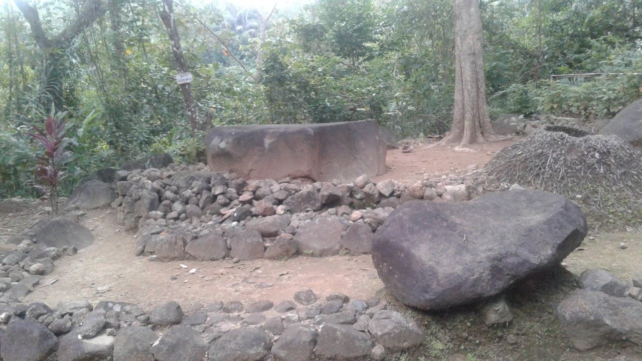
Batu Patapaan 1 stands on level ground before the lowest terrace of the principal punden. Its square stone arrangement measures about 300 by 250 centimeters. The central monolith is approximately 170 by 170 centimeters and 20 to 30 centimeters thick. Its fairly level surface appears to be formed from several broken pieces arranged in a mosaic-like pattern rather than from one solid slab. Two additional monoliths stand on its southwest side, with a smaller one on the northwest.
Batu Patapaan 2
Batu Patapaan 2 has a square plan. Its lowest terrace measures about 300 centimeters on each side. A broad, flat stone occupies the center of the highest terrace. This patapaan stone is approximately 150 centimeters square and rises about 50 to 60 centimeters above the ground.
Batu Patapaan 3
Batu Patapaan 3 consists of three shallow stepped levels, whose slight rises make the structure resemble ordinary ground. It was built from blocks of andesite, a volcanic rock. The square arrangement and terraces are difficult to distinguish, although the clearest surviving lower terrace measures approximately 950 centimeters on the northeast, 820 centimeters on the northwest, and 780 centimeters on the southeast. A monolith about 130 centimeters in diameter stands near the northern corner.
Batu Patapaan 4
Batu Patapaan 4 may be a stone coffin, or sarcophagus. A supporting stone found beneath it during digging led to this interpretation. The feature forms part of the group of stone remains associated with the terraced complex.
Walls, caves, and water features
Defensive wall
An ancient defensive wall followed the village road for approximately 2 kilometers between the Cimuntur and Cileueur sides of the site. Built in courses of stone, it originally stood about 1 meter high. Local residents later reused much of the material in houses and road paving, leaving foundations and other structural remnants.
Artificial caves
Five artificial caves are known at Gunung Susuru, although three have been investigated: Guha Kamuning, Guha Macan 1, and Guha Macan 2. They were cut into the side of a ravine with a slope of approximately 75 degrees. Associated finds include ceramic fragments, ancient buffalo teeth, pig teeth, human bones, and human jaws. A reported gold bowl from one cave prompted searches for supposed treasure. Other finds include stone ornaments and objects made of clay, stone, iron, porcelain, and plates or porcelain vessels.
Wells and river remains
Sumur Taman lies in a cultivated area bounded by the Cimuntur ravine. A stone well is also visible in the river area. During the dry season, exposed boulders in the rivers reveal a stone-well area, while Kamuning Waterfall can be viewed from the riverbank.
Prehistoric and megalithic remains
A stone sarcophagus and other material associated with megalithic culture form part of the site’s physical remains. Finds attributed to the Neolithic period, broadly dated to around 1500 BC, include fossilized human bones and teeth, a stone axe, two cylindrical stones, a stone mortar, a stone seat, a stone projectile, and three kris. These objects are still kept as part of the material associated with Gunung Susuru.