Tikal: Ancient Maya Capital and Urban Center in Guatemala
Site at a Glance
- Rating
- 4.8
- Popularity
- High
- Country
- Guatemala
- Primary era
- Medieval
- External website
- Open
- Eras represented
- Classical, Medieval
- Civilizations
- Maya
- Site type
- City
On this page20 sections
History
Tikal is an ancient Maya urban center in Guatemala, built and developed by the Maya from the Late Preclassic period through the Classic period. It became the capital of the kingdom of Mutul, known in hieroglyphic inscriptions as Yax Mutal or Yax Mutul, and grew into one of the most influential cities of the southern Maya lowlands.
Early settlement and dynastic beginnings
Agriculture was practiced at Tikal by about 1000 BC. A bottle-shaped underground chamber, known as a chultun, contained a ceramic cache dating to approximately 700 to 400 BC. Large pyramids and platforms began to appear during the Late Preclassic period, around 400 to 300 BC, when Tikal participated in the Chikanel cultural tradition shared across central and northern Maya regions.
Two late Chikanel temples may have used corbel vaults, roofs formed by courses of masonry that project inward until they meet near the top. One of these temples carried exterior murals of human figures and scrollwork in yellow, black, pink, and red. Tikal also absorbed artistic influences from the Pacific coast, including Izapan styles visible in early murals and in a broken sculpture from the Acropolis.
Rich burials appeared during the 1st century AD, a period of political and cultural expansion as major northern centers declined. The city’s dynastic line was probably founded by Yax Ehb Xook during that century. It continued for roughly 800 years and included at least 33 rulers.
Growth during the Early Classic period
During the Early Classic period, Tikal became one of the most active political centers in the Maya region. Its inscriptions describe alliances and conflicts with Uaxactun, Caracol, Naranjo, Calakmul, and other Maya states. Uaxactun recorded the capture of Tikal prisoners, while Caracol later defeated Tikal and temporarily displaced it as the leading power in the southern lowlands.
Royal succession was not always straightforward. Around AD 317, Lady Unen Bahlam performed a ceremony marking the end of a k’atun, a Maya calendrical period of approximately 20 years, perhaps indicating an interruption in male dynastic succession. In the early 6th century, another queen known as the Lady of Tikal ruled alongside male co-rulers, including Kaloomte’ B’alam and probably the ruler called Bird Claw.
Chak Tok Ich’aak I, Tikal’s fourteenth ruler, built a palace that later kings preserved and enlarged as part of the Central Acropolis. He was killed in January AD 378, when Tikal was drawn into a major intervention connected with Teotihuacan, a powerful urban and political center in the Valley of Mexico.
Siyaj K’ak’, probably a foreign general associated with Teotihuacan, arrived in the region in January AD 378. Inscriptions call him Lord of the West and indicate that he led an intervention that defeated Tikal’s reigning ruler. A group connected with Teotihuacan apparently settled near the Lost World complex. Siyaj K’ak’ controlled territory around Tikal, including Uaxactun, but did not take Tikal’s throne himself.
Yax Nuun Ayiin I, the son of the Teotihuacan-linked ruler known as Spearthrower Owl, became Tikal’s fifteenth ruler as a child in AD 379. He reigned for 47 years under Siyaj K’ak’s authority. His marriage to a woman from the defeated Tikal dynasty probably helped establish the legitimacy of his son, Siyaj Chan K’awiil II.
During Yax Nuun Ayiin I’s reign, Tikal conquered Río Azul, about 100 kilometers away, and used it as an outpost and trade connection to the Caribbean. Tikal later absorbed Uaxactun and smaller neighboring settlements, while Bejucal and Motul de San José became dependent allies. By the middle of the 5th century, the city’s core territory extended at least 25 kilometers in every direction.
Tikal retained close political and commercial connections with Teotihuacan after the conquest, although its ruling house adopted Maya customs rapidly. Foreign-style costumes, monuments, deities, and architectural forms show the continuing influence of Teotihuacan. Tikal’s political reach also extended southward. K’inich Yax K’uk’ Mo’, founder of the Copán dynasty, spent his childhood and youth at Tikal, and the city may have supported the foundation or refoundation of Copán and Quiriguá.
Rivalry, defeat, and the Tikal Hiatus
A long rivalry between Tikal and Calakmul began in the 6th century. The two kingdoms organized hostile alliance networks, and their rulers used the title kaloomte’, indicating an exceptionally high-ranking sovereign. In AD 562, forces associated with Calakmul and Caracol defeated Tikal. The city’s ruler was probably captured and sacrificed. Tikal was not destroyed, but its political power and regional influence suffered severe losses, and some inhabitants may have been moved to Caracol. At least one Tikal ruler sought refuge at Palenque.
The resulting Tikal Hiatus lasted from the late 6th century into the late 7th century. During this time, Tikal raised few new stelae, large construction declined, and public sculptures were deliberately mutilated. The beginning of the Hiatus is commonly used to mark the division between the Early and Late Classic periods of Mesoamerican chronology.
Tikal continued to contest control of the region. In AD 629 it founded Dos Pilas, about 110 kilometers to the southwest, as a military outpost controlling trade along the Pasión River. B’alaj Chan K’awiil was installed there as a child and initially served Tikal. After Dos Pilas was defeated by Calakmul, he changed allegiance, became Calakmul’s vassal, and attacked Tikal in AD 657. Tikal temporarily lost its king, Nuun Ujol Chaak, but counterattacked Dos Pilas in AD 672 and forced B’alaj Chan K’awiil into exile.
Late Classic revival and collapse
Jasaw Chan K’awiil I ended the Hiatus in AD 682 by erecting Tikal’s first dated monument in 120 years and adopting the title kaloomte’. In AD 695 he defeated and captured the ruler of Calakmul, restoring Tikal’s leading position in the central Maya region, although the city did not regain complete control of the southwestern Petén.
Jasaw Chan K’awiil I and his successor, Yik’in Chan K’awiil, continued campaigns against Calakmul and its allies and extended Tikal’s authority toward Lake Petén Itzá. Much of the monumental architecture visible today was built during their reigns. Tikal’s southern alliance weakened in AD 738, when Quiriguá broke with Tikal, defeated Copán, and became independent with Calakmul’s support.
During the 8th century, Tikal’s rulers brought monuments from different parts of the city together in front of the North Acropolis. Construction slowed during the late 8th and early 9th centuries, while inscriptions became less frequent. Temple III and monuments commemorating the nineteenth k’atun were built around AD 810, but the beginning of the tenth baktun, a larger unit of the Maya Long Count calendar, passed without a celebration in AD 830.
This interruption lasted about 60 years and probably reflected the collapse of central authority. Satellite centers formerly controlled by Tikal began erecting monuments for their own rulers and using the Mutul emblem glyph. In AD 849, Jewel K’awiil was recorded at Seibal as the divine lord of Tikal, but the city’s wider power had largely disappeared. Ixlu and Jimbal later used the same emblem glyph.
Tikal and its immediate hinterland lost most of their population between approximately AD 830 and 950. Warfare in the wider region, population concentration, intensive agriculture, deforestation, erosion, nutrient loss, declining food production, drought, and environmental degradation all contributed to the pressure on the city. Studies have also considered the effects of mercury from cinnabar-based pigments and contamination by algae in parts of the water system.
Jasaw Chan K’awiil II attempted to revive royal authority by erecting a stela in the Great Plaza in AD 869. It was the last monument raised at Tikal. By the end of the 9th century, most residents had left. Squatters occupied royal palaces, built perishable dwellings in ceremonial plazas, blocked doorways, and reused earlier monuments in new rituals. Some accessible royal tombs were opened and looted for jade.
Tikal was almost deserted after AD 950, although a small population may have remained in perishable structures. The last inhabitants probably departed during the 10th or 11th century, after which rainforest covered the ruins for roughly a millennium. Local knowledge of the site survived. Hernán Cortés passed within a few kilometers in 1525 but did not mention the ruins.
Rediscovery and archaeological work
Guatemalan expeditions, guided by local inhabitants, reached Tikal in the 1840s and 1850s. Modesto Méndez and Ambrosio Tut formally explored the site in 1848 with the artist Eusebio Lara and other expedition members. Their report appeared in 1853. Later expeditions mapped, photographed, and described the ruins, including Alfred P. Maudslay’s work in 1881 and 1882, while archaeologists began clearing and recording structures during the 1880s.
The University of Pennsylvania’s Tikal Project mapped the city on an unprecedented scale between 1956 and 1970 and excavated and restored many buildings. Edwin M. Shook and later William R. Coe directed work in the North Acropolis and Great Plaza from 1957 to 1969, recording more than 200 monuments. A Guatemalan archaeological project continued investigations from 1979 to 1984.
Tikal National Park was established on 26 May 1955 as Guatemala’s first protected area. It safeguards approximately 570 square kilometers of forest, wetlands, and savanna around the ruins. The park became a UNESCO World Heritage Site in 1979 under both cultural and natural criteria and forms part of the Maya Biosphere Reserve.
Remains
Tikal’s mapped urban area covers more than 16 square kilometers and contains approximately 3,000 structures in its central zone. A much larger residential landscape extends across about 60 square kilometers, much of which remains uncleared or unexcavated. The city occupies parallel limestone ridges above swampy lowlands, with major groups connected by raised causeways across the wetlands.
Locally quarried limestone forms the principal building material. Quarry depressions were plastered and waterproofed as reservoirs, while natural hollows were also adapted for water storage. Plastered plazas were graded so rainwater flowed through channels into ten reservoirs. The Corriental reservoir contained zeolite minerals and quartz sand that filtered suspended material and contaminants. Earthworks include a trench about 6 meters wide behind a rampart. Some sections once interpreted as fortifications instead formed part of a canal and water-management system.
Causeways and central plazas
Late Classic sacbeob, raised and usually surfaced Maya roads, linked Tikal’s principal groups. Built from packed and plastered limestone, they served as routes and as dams during the rainy season. The Maler Causeway runs north from behind Temple I to Group H. The Maudsley Causeway extends about 0.8 kilometers northeast from Temple IV to Group H, while the Méndez Causeway runs about 1.3 kilometers southeast from the East Plaza to Temple VI. The Tozzer Causeway connects the Great Plaza with Temple IV.
Great Plaza
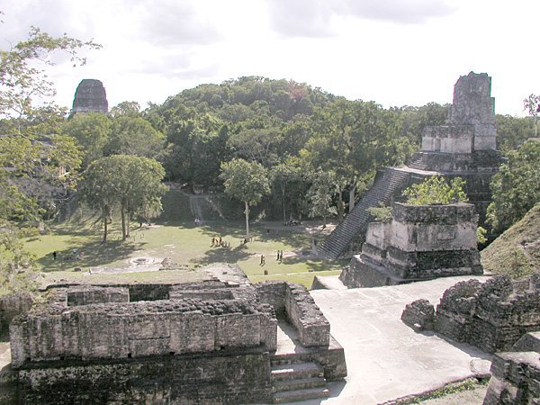
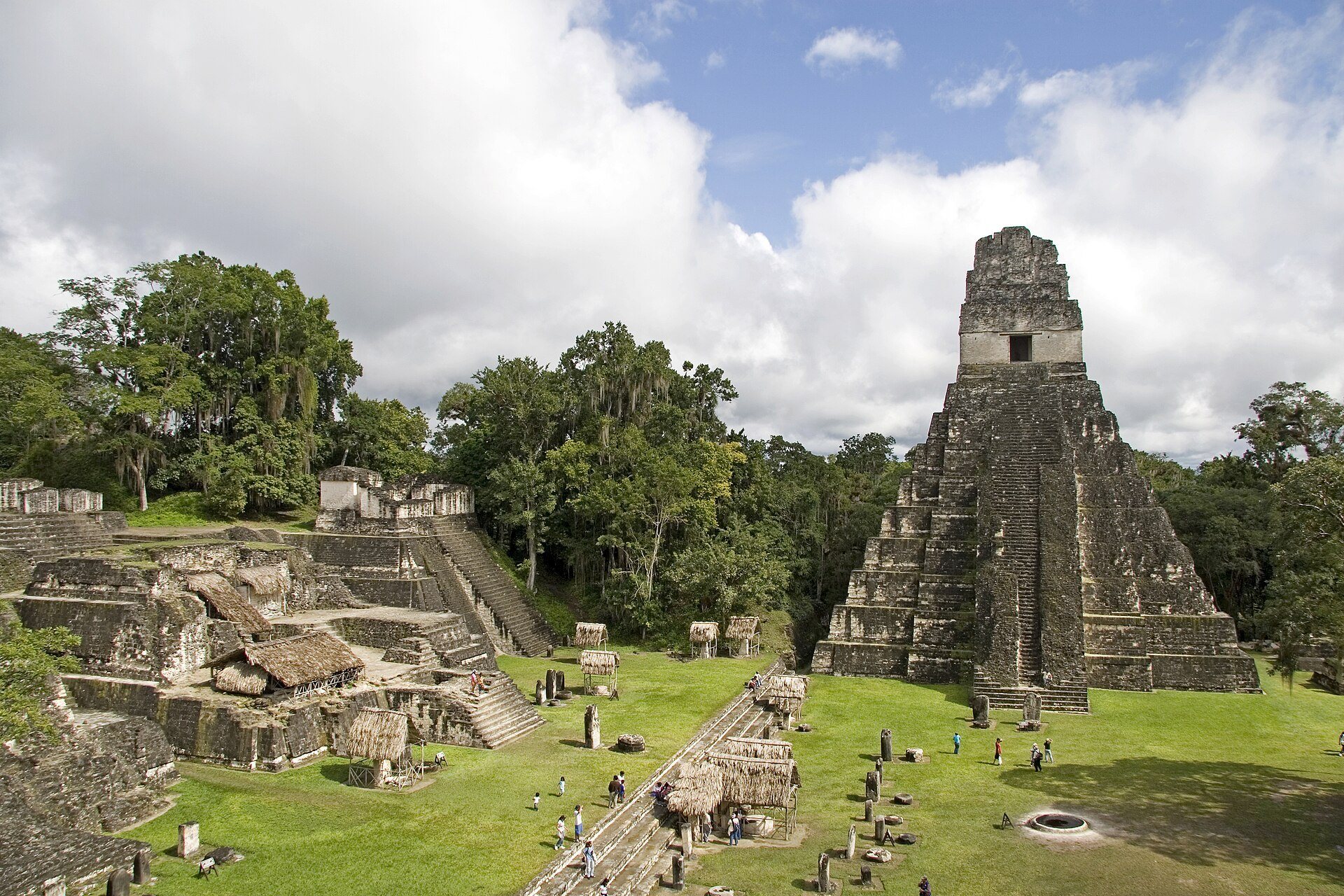
The Great Plaza forms the central architectural space. Temple I stands on its eastern side and Temple II on its western side, with the North Acropolis to the north and the Central Acropolis to the south. Four superimposed white-stucco floors show repeated rebuilding. The earliest dates to approximately 150 BC and the latest to about AD 700.
North Acropolis
The North Acropolis began around 350 BC and developed into a royal funerary complex. Its main platform measures about 100 by 80 meters. Eight temple-pyramids were added during the 6th century, each with a tall roof comb and a stairway flanked by deity masks. By the 9th century, the complex contained 43 stelae and 30 altars, including 18 with hieroglyphic texts and royal portraits. Burials continued there into the Postclassic period.
Central Acropolis
The Central Acropolis is a palace complex immediately south of the Great Plaza. Its buildings surround six courtyards joined by passages and stairs, forming a complex about 215 meters long. The term palace is an archaeological label rather than proof of a single function, since the buildings may have served as royal residences, administrative centers, or both.
Southern and western architectural groups
South Acropolis and Plaza of the Seven Temples
The South Acropolis stands beside Temple V on a basal platform covering more than 20,000 square meters. To its west, the Plaza of the Seven Temples is bordered by a row of nearly identical temples, palaces on its southern and western sides, and an unusual triple ballcourt on its northern side. Structure 5D-96 is the restored central temple on the eastern side of the plaza.
Group G
Group G, south of the Méndez Causeway, is a large Late Classic palace-type complex. Its lower level contains 29 vaulted rooms, with remains of two additional rooms above. A gigantic mask frames its entrance.
Group H and related complexes
Group H is centered on a large plaza north of the Great Plaza and bordered by Late Classic temples. Complex P lies within Group H and contained Stela 20, which was later transferred to Guatemala City’s National Museum of Archaeology and Ethnology. Group 6C-16 was an elite residential complex with stucco masks, murals of ballplayers, relief sculpture, and buildings showing Teotihuacan-related features.
Temples and ceremonial complexes
Lost World complex
The Lost World complex is a major Preclassic ceremonial group arranged around a pyramid and an eastern platform with three temples. By approximately AD 250 to 300, its architecture had acquired features associated with Teotihuacan, and the complex may have served as a royal burial area between approximately AD 250 and 378.
The Lost World Pyramid, Structure 5C-54, rises about 30 meters. It has stairways on all four sides, a flat summit that may have supported a perishable structure, and stucco masks of the sun god. The pyramid reached its final form under Chak Tok Ich’aak in the 4th century AD.
Principal temple-pyramids
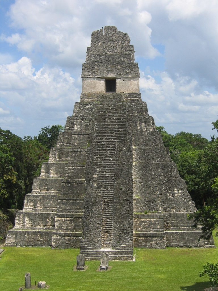
Six principal temple-pyramids are designated Temples I through VI. Temple I, also called the Temple of the Great Jaguar or Temple of Ah Cacao, is a 47-meter funerary pyramid dedicated to Jasaw Chan K’awiil I and completed around AD 740 to 750. Temple II, the Temple of the Masks, is 38 meters high and was built around AD 700.
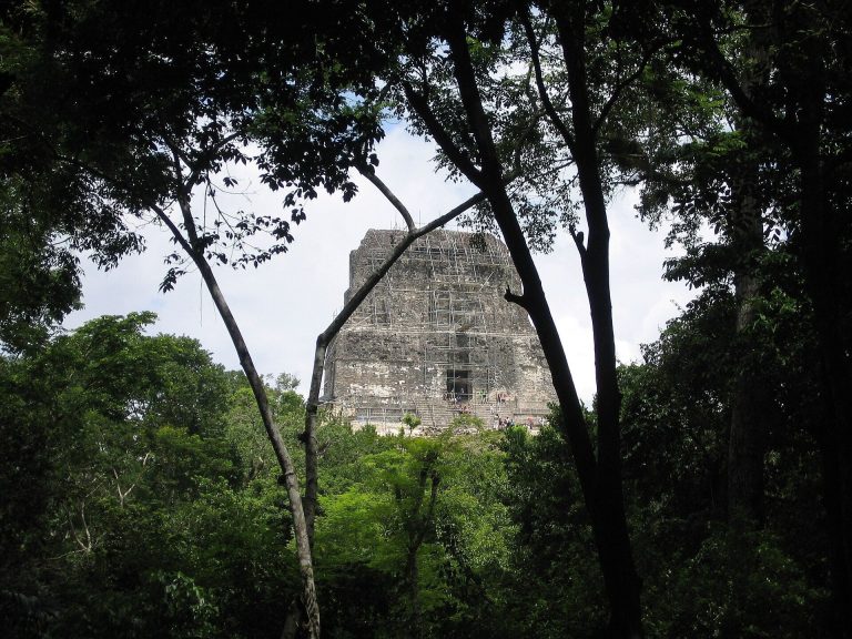
Temple III, the Temple of the Jaguar Priest, reaches approximately 55 meters and may depict the ruler known as Dark Sun in a ritual dance around AD 810. Temple IV, the Temple of the Double-Headed Serpent, rises about 70 meters and is associated with Yik’in Chan K’awiil. Temple V is a 57-meter mortuary pyramid for an unidentified ruler. Temple VI, the Temple of the Inscriptions, was dedicated in AD 766 and bears monumental hieroglyphic panels.
Other ceremonial structures
Tikal contains nine Twin-Pyramid complexes. Each generally has two flat-topped pyramids facing one another along an east-west axis, stairways on all four sides, rows of plain stelae, a carved stela-and-altar pair, and a long vaulted building with one room and nine doorways. These complexes were built at roughly 20-year intervals during the Late Classic. Group Q was built by Yax Nuun Ayiin II in AD 771 to mark the end of the seventeenth k’atun, while Group R dates to AD 790.
Structure 5D-43 is an unusual radial temple with a sloping-panel and vertical-panel profile known as talud-tablero, an architectural arrangement strongly associated with Teotihuacan. Structures 5C-49 and 5C-53 also display Teotihuacan-related forms. The Great Plaza Ballcourt lies between Temple I and the Central Acropolis. The Bat Palace, or Palace of the Windows, stands west of Temple III, while Complex N lies farther west and dates to AD 711.
Monuments, lintels, and burials
Tikal’s wooden lintels were made from sapodilla beams placed above temple doorways. Lintel 3 from Temple IV, now in Basel, Switzerland, portrays Yik’in Chan K’awiil seated on a palanquin. Stone stelae carry royal figures and hieroglyphic texts. Stela 4, dated to AD 396, combines Maya and Teotihuacan imagery, while Stela 6, dated to AD 514, names the Lady of Tikal. Stelae 10 and 12 associate Kaloomte’ B’alam with royal accession, prisoner capture, and year-ending ceremonies involving the Lady of Tikal.
Stela 29 bears the earliest surviving Long Count date from the Maya lowlands, corresponding to AD 292, and is the earliest Tikal monument with the city’s emblem glyph. Stela 31 records Siyaj Chan K’awiil II’s accession and Siyaj K’ak’s arrival at El Perú and Tikal in January AD 378. Stela 39 shows Chak Tok Ich’aak trampling a bound captive. Stela 30 was the first surviving monument raised after the Hiatus, and Stela 11, dedicated by Jasaw Chan K’awiil II in AD 869, was Tikal’s last monument.
Burial 1 contained a fine ceramic bowl whose handle forms a three-dimensional bird’s head and neck. Burial 48 held the remains of Siyaj Chan K’awiil II and two sacrificed adolescents. Burial 85, a Late Preclassic tomb, has been cautiously linked with Yax Ehb Xook. Burial 116 contained Jasaw Chan K’awiil I and rich offerings. Burial 195 preserved impressions of four wooden effigies of K’awiil, a Maya deity associated with royal power, while Burial 196 contained a jade mosaic vessel topped with the head of the Maize God.